jojo762
-
Posts
4,228 -
Joined
-
Last visited
Content Type
Profiles
Blogs
Forums
American Weather
Media Demo
Store
Gallery
Everything posted by jojo762
-
H85 DP's of 20C right now just west of TOP according to mesoanalysis too. Maybe a tad high given that the H85 DP on the 19Z KTOP RAOB was aoa 12.2C and it currently shows it at 17C, but also there appears to be moisture transport of 20m/s, so its not out of the question I suppose... Juicy at and above the surface
-
Ironically the first storms to fire are along the "dryline" in W/SW/NC KS along the northern periphery of the southern plains sub tropical ridge. Instability is pretty impressive generally south of the NE/KS border. But shear is pretty underwhelming attm with only 20-30kts of eff. shear across the area. But that should increase as the main-- but subtle-- shortwave rounds the base of the ridge, increasing shear to 35-45kts. Still is some tornado potential later this evening as a 25-35kt LLJ kicks in around the time that shortwave will kick into the area, especially if there is still a discrete storm or two. Looking pretty linear though in KS already, but doubt that much of that activity will maintain, especially with southward extent due to meager shear. However, even if we were to manage a discrete supercell prior to the MCS... or in front of/away from the MCS... it would still likely be HP given PWAT's of 2-2.5in and unimpressive upper-level winds.
-
The pretty massive MCV over E NE attm is impressive... at least geographically/size speaking. As long as there isn't pestering convection, like there always is in 2015, then today should be pretty good. Main question will be how HP are any supercells that develop going to be and how quickly do they/ do they not form into a messy WF MCS. 06Z 4K NAM shows CI around 23-00z in E NE and almost automatically develops it into a bow-echo by 01Z. Could be a small window in there to get an intense supercell.
-
Potentially localized big day in SE NE/ NE KS today... SPC is mildly excited as well, but there is uncertainty regarding CI later this afternoon/evening due to the massive MCS encompassing much of eastern Nebraska and Northern Kansas attm. An impressive parameter space will likely exist on the warm side of the boundary evidenced by the the 00Z 12NAM forecast sounding below from Falls City, NE at 00z/ Sunday... ALSO... The 06Z D1SWO from SPC... DAY 1 CONVECTIVE OUTLOOK NWS STORM PREDICTION CENTER NORMAN OK 1259 AM CDT SAT AUG 08 2015 VALID 081200Z - 091200Z ...THERE IS A SLGT RISK OF SVR TSTMS LOWER MO VALLEY... ...THERE IS A SLGT RISK OF SVR TSTMS BLACK HILLS AREA... ...THERE IS A SLGT RISK OF SVR TSTMS CNTRL HIGH PLAINS... ...THERE IS A MRGL RISK OF SVR TSTMS N-CNTRL STATES... ...THERE IS A MRGL RISK OF SVR TSTMS ERN GULF COAST STATES... ...SUMMARY... SEVERE STORMS APPEAR MOST LIKELY OVER PARTS OF THE LOWER MISSOURI VALLEY DURING THE LATE AFTERNOON AND EVENING. TORNADOES...VERY LARGE HAIL...AND DAMAGING WINDS WILL BE POSSIBLE. LARGE HAIL AND SEVERE WINDS SHOULD ACCOMPANY A FEW STORM CLUSTERS OVER THE NORTHERN AND CENTRAL HIGH PLAINS IN THE LATE AFTERNOON AND EVENING. ...LOWER MO VALLEY AREA... PRIMARY FORECAST CONCERN IS OVER THE POTENTIAL FOR A SIGNIFICANT TORNADO SETUP ACROSS A LOCALIZED PORTION OF SERN NEB TO SWRN IA WHERE A 10 SIG TOR PROBABILITY WAS CONSIDERED FOR THIS OUTLOOK. BUT WITH PREDICTABILITY RESIDING PREDOMINATELY ON THE MESO-BETA SCALE...WILL DEFER TO LATER OUTLOOKS FOR POSSIBLE DELINEATION OF AN ENHANCED RISK PROBABILITY. ONGOING MCS CENTERED OVER S-CNTRL NEB/N-CNTRL KS SHOULD BE IN A DECAYING STATE AT 12Z THIS MORNING. REMNANT MCV IS PROGGED TO SHIFT E THIS MORNING OVER IA AND THEN DAMPEN OVER THE MIDWEST. GUIDANCE IS HIGHLY CONSISTENT WITH A LACK OF DIURNALLY DRIVEN CONVECTIVE DEVELOPMENT ASSOCIATED WITH THE REMNANT MCV PERHAPS DUE TO THE FEATURE OUTPACING THE BUOYANT MOIST SECTOR CURRENTLY ALONG THE MS RIVER WWD. THE MORE PROBABLE SCENARIO IS FOR RENEWED TSTM DEVELOPMENT LATE AFTERNOON OR EVENING ACROSS PARTS OF THE LOWER MO VALLEY WHERE PRONOUNCED DIFFERENTIAL HEATING IS EXPECTED ON THE SRN EDGE OF RESIDUAL CLOUD COVERAGE/OUTFLOW BOUNDARY FROM THE DECAYING MCS. A RATHER MOISTURE-RICH BOUNDARY LAYER BENEATH A PLUME OF MODERATELY STEEP MID-LEVEL LAPSE RATES WILL RESULT IN A CORRIDOR OF STRONG DESTABILIZATION WITH MLCAPE AOA 2500 J/KG. UNCERTAINTY DOES EXIST OVER THE TIMING OF TSTM INITIATION GIVEN CAPPING CONCERNS WITH LARGELY 700-MB SWLYS MAINTAINING WAA. SOME CAMS SUGGEST TSTMS WILL BE DELAYED UNTIL JUST AFTER SUNSET AS THE LLJ INTENSIFIES AND PROVIDES NECESSARY FORCED ASCENT. OTHER GUIDANCE INDICATES LATE AFTERNOON INITIATION PERHAPS AIDED BY A SUBTLE MID-LEVEL IMPULSE EJECTING FROM THE FOUR CORNERS AREA. SHOULD THIS OCCUR...RELATIVELY STRONG LOW-LEVEL SRH ALONG THE EARLY-DAY OUTFLOW BOUNDARY/RESULTANT EFFECTIVE FRONT COULD FAVOR A COUPLE INTENSE SUPERCELLS /PARTICULARLY GIVEN THAT OVERALL FORCING SHOULD BE MODEST/. A CONDITIONAL RISK FOR VERY LARGE HAIL AND A STRONG TORNADO IS APPARENT. WILL MAINTAIN INHERITED SIGNIFICANT SEVERE PROBABILITIES /DRIVEN BY HAIL/...BUT MESOSCALE PREDICTABILITY IS TOO LOW FOR A LOCALIZED UPGRADE TO ENHANCED RISK PROBABILITIES THIS OUTLOOK. REGARDLESS OF WHEN TSTM INITIATION OCCURS...UPSCALE GROWTH INTO A LATE EVENING MCS SEEMS PROBABLE WITH A DAMAGING WIND RISK MOST LIKELY DURING THE EARLY STAGES OF STORM-SCALE MERGERS UNTIL CONVECTION TENDS TO WEAKEN OVERNIGHT.
-
How does this river not have a flood warning on it? It's at 41.51ft and flood stage is only 26ft, and the record is 44.16... Especially given the amount of "impacts" that have been reached. 40 U.S. Highway 80 will be flooded and closed. Several thousand acres of land will remain flooded for several days. 38 U.S. Highway 271 will is flooded and closed. Expect severe flooding to continue for several more days. 36 Expect moderate to severe flooding with some secondary roadways near the river to be closed. Also homes will be threatened with flooding and preparations should be completed for a major flood. 32 Lowland flooding will continue to slowly decrease over the next several days. 29 Expect lowland flooding to continue with oil field operations curtailed. 26 Expect minor lowland flooding with camps and picnic areas near the river suffering some flooding. http://water.weather.gov/ahps2/hydrograph.php?wfo=shv&gage=gdwt2 EDIT: It would appear basing off of other gauges along the river that this specific gauge malfunctioned.
-
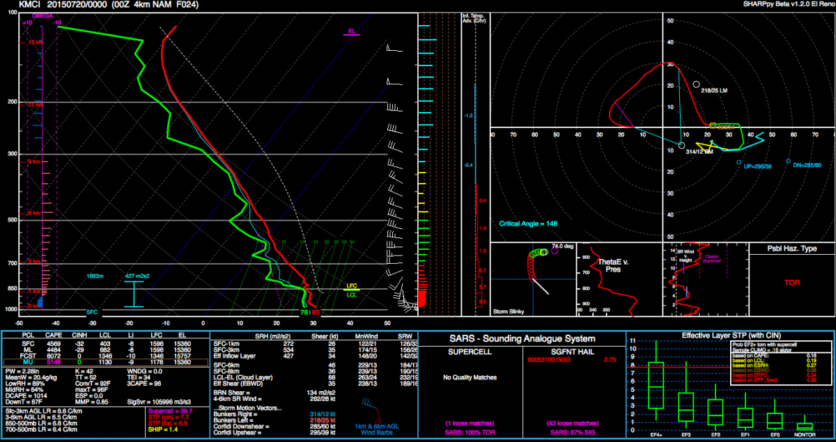
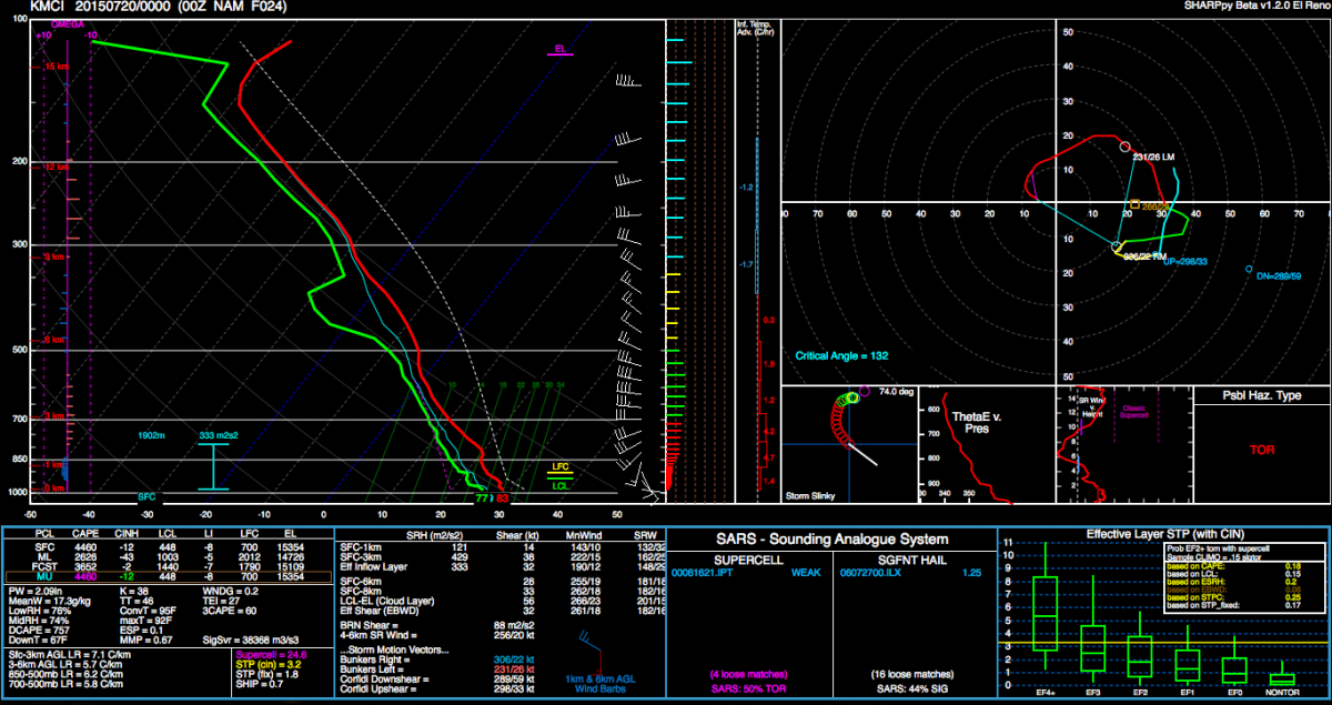
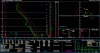
**Could** be a possible sleeper day E/NE/SE KS and areas eastward in WC MO. Both 00Z 4K and 12K NAM solutions show impressive instability building into the area with MUCAPE values of 3000-5000J/KG widespread overlapped by 0-500mb bulk shear of 30-50kts... All with very impressive veering with height leading to elongated curved low-level hodographs (especially along the OFB left over from the mid/early morning MCS) owing to 0-3KM SRH of 300-500m2/s2 along the OFB with 30-40kts of SFC-700mb flow, and especially in the KC metro area. Which is an area that both models pin point as an area of maximized parameter space evidenced by 00Z/Monday forecast soundings from the 4K and 12K NAM for KMCI. The 4K NAM also shows vigorous discrete supercell development (perhaps morphing into a cluster eventually) over this same area, which could lead to a dangerous and unexpected scenario. Then again absolutely nothing could happen, as the 00Z GFS showed no convective development over the area, and the NAM hinted to continuous pestering convection over NE KS, and eventually re-intensifying over EC KS. Will have to reevaluate this as 06Z models come in, and see if the 06Z 4K NAM maintains this scenario as the 18Z and 00Z runs did. Also... Flash flooding is likely to be a concern if any storms do form and persist... as storm motions are likely to be slow and PWAT values are 2-2.4in across the region, which according to SPC Sounding climatology is quite anomalous. As even the record PWAT's from all the 12Z soundings for July 19 is 2.27in and 00z/July 20 is 2.28in. Which could possibly be broken. But, generally the 4K NAM is on a bit of an island attm as far as the tornado-potential goes at least... doesn't mean it could be right though. But at the very least a few severe thunderstorms going up an environment of high-extreme instability and more than sufficient shear would produce large hail and damaging winds. FWIW, last time the 4K NAM showed something like this (and with run to run persistence) a few weeks ago, it nailed it. With Lee Summit and areas just north of the EAX office getting a few tornadoes.

-
And another "large and extremely dangerous tornado" THE NATIONAL WEATHER SERVICE IN ABERDEEN HAS ISSUED A * TORNADO WARNING FOR... NORTHWESTERN GRANT COUNTY IN NORTHEASTERN SOUTH DAKOTA... SOUTHEASTERN DAY COUNTY IN NORTHEASTERN SOUTH DAKOTA... NORTH CENTRAL CODINGTON COUNTY IN NORTHEASTERN SOUTH DAKOTA... SOUTHWESTERN ROBERTS COUNTY IN NORTHEASTERN SOUTH DAKOTA... * UNTIL 830 PM CDT * AT 744 PM CDT...A CONFIRMED LARGE AND EXTREMELY DANGEROUS TORNADO WAS LOCATED NEAR ANTELOPE LAKE...OR NEAR WEBSTER...MOVING SOUTHEAST AT 25 MPH. THIS IS A PARTICULARLY DANGEROUS SITUATION. HAZARD...DAMAGING TORNADO. SOURCE...PUBLIC CONFIRMED TORNADO. PUBLIC REPORTS DEBRIS IN WEBSTER. IMPACT...YOU ARE IN A LIFE THREATENING SITUATION. FLYING DEBRIS MAY BE DEADLY TO THOSE CAUGHT WITHOUT SHELTER. MOBILE HOMES WILL BE DESTROYED. CONSIDERABLE DAMAGE TO HOMES...BUSINESSES AND VEHICLES IS LIKELY AND COMPLETE DESTRUCTION IS POSSIBLE. * THE TORNADO WILL BE NEAR... BLUE DOG LAKE AROUND 750 PM CDT. WAUBAY AROUND 755 PM CDT. BITTER LAKE AROUND 800 PM CDT. ORTLEY AROUND 805 PM CDT. SUMMIT AROUND 820 PM CDT. PRECAUTIONARY/PREPAREDNESS ACTIONS... TO REPEAT...A LARGE...EXTREMELY DANGEROUS AND POTENTIALLY DEADLY TORNADO IS ON THE GROUND. TO PROTECT YOUR LIFE...TAKE COVER NOW! MOVE TO A BASEMENT OR AN INTERIOR ROOM ON THE LOWEST FLOOR OF A STURDY BUILDING. AVOID WINDOWS. IF YOU ARE OUTDOORS...IN A MOBILE HOME...OR IN A VEHICLE...MOVE TO THE CLOSEST SUBSTANTIAL SHELTER AND PROTECT YOURSELF FROM FLYING DEBRIS. && LAT...LON 4523 9751 4540 9745 4533 9692 4506 9703 TIME...MOT...LOC 0044Z 293DEG 24KT 4530 9740 TORNADO...OBSERVED TORNADO DAMAGE THREAT...CONSIDERABLE HAIL...1.25IN
-
...A TORNADO WARNING REMAINS IN EFFECT UNTIL 830 PM CDT FOR EAST CENTRAL DAY AND SOUTHWESTERN ROBERTS COUNTIES... AT 754 PM CDT...A CONFIRMED LARGE AND EXTREMELY DANGEROUS TORNADO WAS LOCATED OVER ENEMY SWIM HOUSING...OR 12 MILES NORTHEAST OF WEBSTER... MOVING SOUTHEAST AT 20 MPH. THIS IS A PARTICULARLY DANGEROUS SITUATION. HAZARD...DAMAGING TORNADO. SOURCE...PUBLIC CONFIRMED TORNADO. IMPACT...YOU ARE IN A LIFE THREATENING SITUATION. FLYING DEBRIS MAY BE DEADLY TO THOSE CAUGHT WITHOUT SHELTER. MOBILE HOMES WILL BE DESTROYED. CONSIDERABLE DAMAGE TO HOMES...BUSINESSES AND VEHICLES IS LIKELY AND COMPLETE DESTRUCTION IS POSSIBLE. THE TORNADO WILL BE NEAR... CAMPBELL SLOUGH AROUND 800 PM CDT. RUDEBUSCH CORNER AROUND 815 PM CDT. PRECAUTIONARY/PREPAREDNESS ACTIONS... TO REPEAT...A LARGE...EXTREMELY DANGEROUS AND POTENTIALLY DEADLY TORNADO IS ON THE GROUND. TO PROTECT YOUR LIFE...TAKE COVER NOW! MOVE TO A BASEMENT OR AN INTERIOR ROOM ON THE LOWEST FLOOR OF A STURDY BUILDING. AVOID WINDOWS. IF YOU ARE OUTDOORS...IN A MOBILE HOME...OR IN A VEHICLE...MOVE TO THE CLOSEST SUBSTANTIAL SHELTER AND PROTECT YOURSELF FROM FLYING DEBRIS. && LAT...LON 4544 9702 4534 9704 4543 9737 4548 9734 TIME...MOT...LOC 0054Z 305DEG 18KT 4544 9730 TORNADO...OBSERVED TORNADO DAMAGE THREAT...CONSIDERABLE HAIL...1.50IN
-
Just from the app on my phone I think the outflow is on the tip of the hook... But I'm not sure.. But it definitely looks north of the boundary at this point. Impressive hook though. Really close to the radar
-
Isolated supercell developed along a boundary (maybe a tad north now of it now) west of Topeka, should be interesting to see if it takes advantage of the impressive parameters in place. 0-3KM CAPE 150-200J/KG, good SFC-vorticity along the boundary, MLCAPE of 3500-4000J/KG, EFF shear of 40-50kts, 0-3KM SRH of ~300m2/s2... STP is 3-5 across NE/E KS. Virtually no CIN left according to mesoanalysis. Localized flooding will be a concern where this lone storm crosses too... Forward speed around 15-25mph. And PWAT's around 2in...
-
Could be a bit of a localized big day across SE NE/NE KS/NW MO/SW IA... Recent High-Rest guidance shows numerous supercells going up in this area, with a somewhat impressive parameter space. 2000-4000J/KG MUCAPE overlapped by ~50kts of 0-500mb bulk shear... 0-3KM EHI's make it in the 6-10 range later this afternoon/evening. 0-3KM SRH makes it into the 450-600m2/s2 range this evening too... 00Z NAM forecast Sounding in SE NE. And another on in Lincoln, NE at 00z, hodographs are superb...
-
In a marginal risk with not even a 2% tornado prob... Just odd.
-
Guess someone died on the Kansas Turnpike (I-35) yesterday SW of Emporia due to flash flooding. ICT said that 4-6.5in of rain fell in about a 1:30-2:00 or so period..
-
Parts of I-35 closed near Emporia, KS... 3-5in fell in 1:30 hours.. THE NATIONAL WEATHER SERVICE IN TOPEKA HAS EXTENDED THE * FLASH FLOOD WARNING FOR... SOUTHERN LYON COUNTY IN EAST CENTRAL KANSAS... * UNTIL 1230 AM CDT SATURDAY * AT 538 PM CDT...COUNTY DISPATCH REPORTED FLASH FLOODING ACROSS THE WARNED AREA. FAST MOVING WATER IS RUNNING OVER INTERSTATE 35 BETWEEN MILE MARKERS 118 AND 119. NORTHBOUND LANES HAVE BEEN CLOSED. UP TO FOUR INCHES OF RAIN HAVE ALREADY FALLEN. FLASH FLOODING IS ALREADY OCCURRING. * SOME LOCATIONS THAT WILL EXPERIENCE FLOODING INCLUDE... EMPORIA...OLPE...HARTFORD AND NEOSHO RAPIDS. THIS INCLUDES KANSAS TURNPIKE BETWEEN MILE MARKERS 117 AND 125.
-
Today looks like another marginal day, but across North Central and Northeast KS possibly extending down into C/SC KS. Could get a few supercells to develop along the WF with damaging winds, some hail, and maybe a tornado due to impressive turning with height, but speed shear is marginal really with 0-6KM Shear progged at AOA 25-35kts across NE KS, and possibly 35-45kts across NC KS... Moderate to strong instability should be built INVOF the warm-front and areas south, with around 2000-3000J/KG MUCAPE with localized maxes along the warm front... Meanwhile a subtle short wave should move into the area around 20Z or so and kick of a round of thunderstorms some of which could pose the severe threats above. FWIW, the 4K NAM (which is a bit of an outlier with this solution compared to SSEO guidance) has an impressive cluster/bow-echo developing across NC KS by 20Z and sustaining till about 03-04Z/Saturday when it has weakened near the KS/MO border. However latest iterations of the HRRR (not that is really that reliable) have shown widespread convection developing as soon as 17-19Z across C KS S/SW'ward into NW/W OK which would probably put more of a lid on the already marginal severe threat, and lead to more of a moderate/heavy rainfall threat given PWAT's of ~2 inches, and the NW/SW orientation of the broken "line." But that seem less probable than the current thinking of isolated/scattered TSTM's/some SVR along the WF, but not out of the question given the ejection of the S/W around 18-21Z.
-
Appears that a pretty impressive bow echo is developing across S KS... And might be trying to develop a book-end vortex, but maybe a tad too early to tell.
-
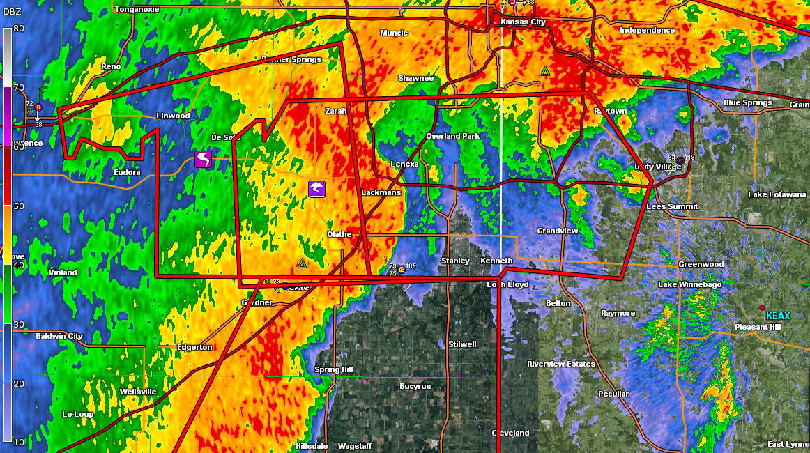
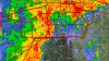
Two pretty obvious curl's on reflectivity. Possible TDS over Lenexa.
-
THE NATIONAL WEATHER SERVICE IN TOPEKA HAS ISSUED A * TORNADO WARNING FOR... CENTRAL JOHNSON COUNTY IN EAST CENTRAL KANSAS... SOUTHWESTERN JACKSON COUNTY IN WEST CENTRAL MISSOURI... * UNTIL 600 PM CDT * AT 536 PM CDT...A SEVERE THUNDERSTORM CAPABLE OF PRODUCING A TORNADO WAS LOCATED OVER OLATHE...MOVING EAST AT 40 MPH. HAZARD...TORNADO. SOURCE...RADAR INDICATED ROTATION. IMPACT...FLYING DEBRIS WILL BE DANGEROUS TO THOSE CAUGHT WITHOUT SHELTER. MOBILE HOMES WILL BE DAMAGED OR DESTROYED. DAMAGE TO ROOFS...WINDOWS AND VEHICLES WILL OCCUR. TREE DAMAGE IS LIKELY. * THIS DANGEROUS STORM WILL BE NEAR... LENEXA AROUND 540 PM CDT. OVERLAND PARK AROUND 545 PM CDT. PRAIRIE VILLAGE...MISSION AND COUNTRYSIDE AROUND 550 PM CDT. LEAWOOD AROUND 555 PM CDT. GRANDVIEW AND RAYMORE AROUND 600 PM CDT.
-
Tornado reported now... rotation on radar has become rather meh now.
-
Strong rotation as well near Eudora, KS... West of Kansas city moving east toward the metro at 40mph. TVS on it. EDIT: Was strong rotation...
-
...A TORNADO WARNING REMAINS IN EFFECT FOR NORTH CENTRAL CASS COUNTY UNTIL 830 PM CDT... AT 807 PM CDT...A CONFIRMED TORNADO WAS LOCATED NEAR PLEASANT HILL... AND MOVING SOUTHEAST AT 15 MPH. HAZARD...DAMAGING TORNADO AND QUARTER SIZE HAIL. SOURCE...WEATHER SPOTTERS CONFIRMED TORNADO. IMPACT...FLYING DEBRIS WILL BE DANGEROUS TO THOSE CAUGHT WITHOUT SHELTER. MOBILE HOMES WILL BE DAMAGED OR DESTROYED. DAMAGE TO ROOFS...WINDOWS AND VEHICLES WILL OCCUR. TREE DAMAGE IS LIKELY. LOCATIONS IMPACTED INCLUDE... EAST LYNNE AND STRASBURG.
-
TOR warned cell also near Columbia, MO EDIT: Also looks like the current supercell NW of the original, TOR warned one, might need a tornado warning looking better and better, and has also had reports of funnel clouds.
-
Seems like EAX might have to take cover... Considering the hook/rotation will go right over them, and close to the radar site soon.
-
Don't have the best GR2A skills yet, but....

-
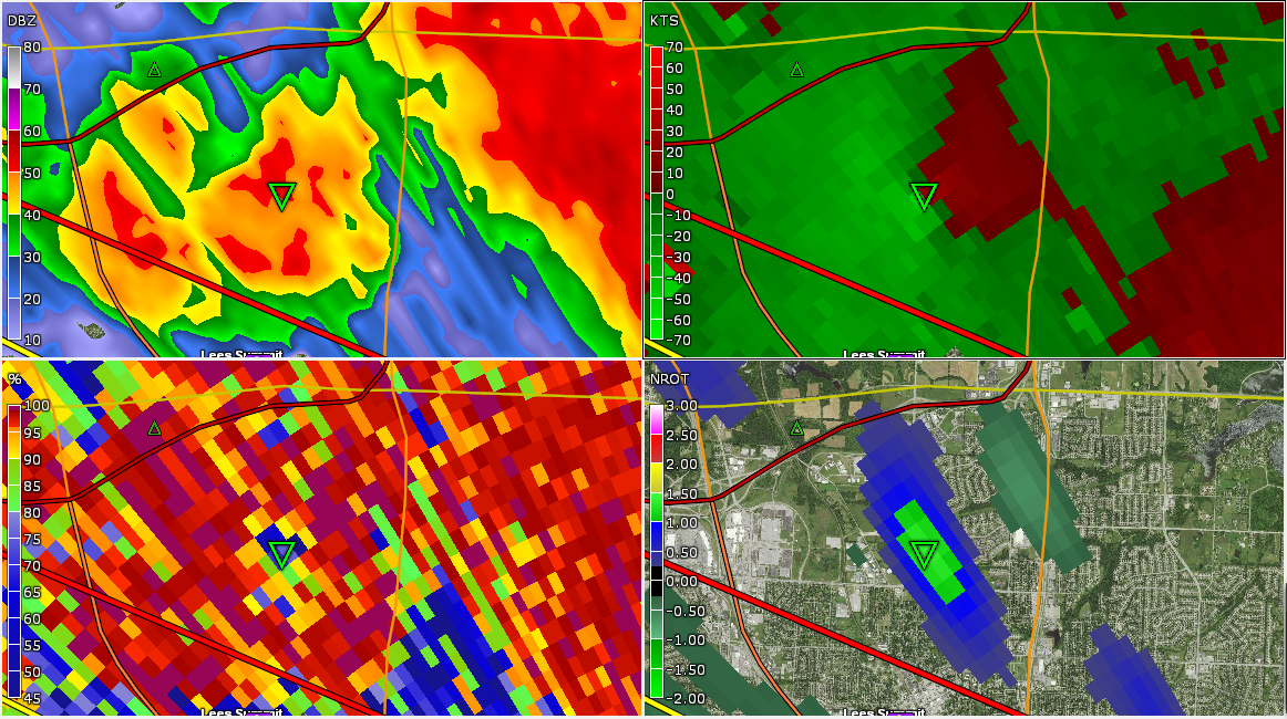
TDS and TVS as well BULLETIN - EAS ACTIVATION REQUESTED TORNADO WARNING NATIONAL WEATHER SERVICE KANSAS CITY/PLEASANT HILL MO 654 PM CDT WED JUL 1 2015 THE NATIONAL WEATHER SERVICE IN PLEASANT HILL HAS ISSUED A * TORNADO WARNING FOR... SOUTHEASTERN JACKSON COUNTY IN WEST CENTRAL MISSOURI... * UNTIL 730 PM CDT * AT 652 PM CDT...A CONFIRMED TORNADO WAS LOCATED NEAR LEE'S SUMMIT...AND MOVING SOUTHEAST AT 20 MPH. HAZARD...DAMAGING TORNADO AND PING PONG BALL SIZE HAIL. SOURCE...WEATHER SPOTTERS CONFIRMED TORNADO. IMPACT...FLYING DEBRIS WILL BE DANGEROUS TO THOSE CAUGHT WITHOUT SHELTER. MOBILE HOMES WILL BE DAMAGED OR DESTROYED. DAMAGE TO ROOFS...WINDOWS AND VEHICLES WILL OCCUR. TREE DAMAGE IS LIKELY. * LOCATIONS IMPACTED INCLUDE... GREENWOOD...LAKE LOTAWANA...LONE JACK AND TARSNEY LAKES.