

MDphotog
-
Posts
204 -
Joined
-
Last visited
Content Type
Profiles
Blogs
Forums
American Weather
Media Demo
Store
Gallery
Posts posted by MDphotog
-
-
2nd round in now. Less lightning, still good amount of rain.
-
So, not sure if I can explain this well enough, but here goes. Is there such a thing as a super gust front or meso-gust front? I like to think I am pretty aware of a standard gust front signature on radar, but I just saw something interesting on College of DuPage's Satellite loop. If you click on the GOES-East Washington DC (Localized Sector) and set it to 96 frames. Up in Eastern Central PA around Pittsburg watch at frame 66 (18:11:17 UTC) to frame 88 (20:06:17 UTC). There is a very large bow arc that appears to shoot off a large cluster of storms and races south east. This is now triggering more storms out in the west. This seems much larger than a typical gust front, or at least that I can recall. Anyone chime in to what I was looking at? Thanks for any help.
-
17 minutes ago, mattie g said:
Interesting that the same thing is happening today as it did yesterday. The electricity in the cell that clipped Burke yesterday was super impressive.
I'm not sure if is normal for up here in Williamsport/Hagerstown or not. We just moved in two weeks ago. Haha. Looks like round two is coming in now.
-
I think I have seen more cloud to ground bolts in this storm than all last year. I approve.
-
 1
1
-
-
30 minutes ago, Kmlwx said:
Complex heading for Boonsboro area is pulsing up now. Warned for 70mph now.
That one was pretty nasty coming through Williamsport. Lot of small/med branches down. Tons of cloud to ground lightning. Still seeing it as it heads East.
-
1
-
-
6 hours ago, Weather Will said:
WB 12Z NAM is wetter through today compared to 6Z.

I'm going to take a gamble here...but I'm thinking this won't verify for us up in Frederick County.
-
Wow, got stuck under one of these slow movers that popped from in Frederick. Heavy rain for 20mins or so, nice bit of thunder and lightning too. Slowed now, had some pretty good street flooding for a bit.
-
Playing chicken with these pulse storms...start the grill or not... Storms popping around me but nothing here yet.
-
43 minutes ago, MN Transplant said:
Don’t take this as gospel, but I don’t think the cicadas get high enough to be seen by radar.
If it can rain frogs, I think a storm could do it.
") Yeah, that was a post in jest. That was an impressive storm that rolled through, all the way to...well I think that cell is still going.
Yeah, that was a post in jest. That was an impressive storm that rolled through, all the way to...well I think that cell is still going.
-
Wow, that developed into a nice beefy line of storms. Congrats to the Central and East crews.
-
1
-
-
9 minutes ago, wxtrix said:
deafening continuous thunder and incredible lightning as the torrential rain has moved east of me.
Yeah I thought that cell was about fizzle out with the gust front showing up, but it looks like it just shrugged it off and is building even more.
-
So that storm coming out of Charlestown WV, gust front or a metric ton of Cicadas being pushed ahead by the wind?
-
3 hours ago, WeatherShak said:

Wondering what’s going on here. And there’s two other USAF tankers in the air nearby that I’ve checked in black.
Interesting. I saw the same thing when the President was addressing Congress a little while back, except it had the call sign Zombe worryingly. My dad thought it might be continuation of government related. Not sure what’s going on with it today.
-
1
-
-
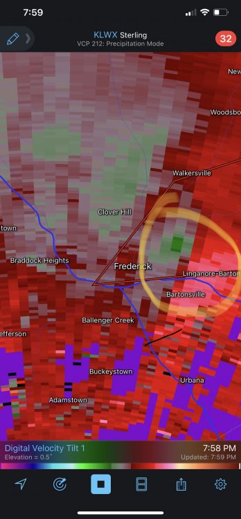
North of Frederick getting some small thunderstorms. Pretty good amounts of Lightning for their size. No hail here though, just rain.
-
Hearing scanner reports of multiple trees/wires down around MD 26 in Frederick County.
-
1 minute ago, Eskimo Joe said:
Another Tornado Warning coming out for Carroll.
That is the same cell right? All the way back to the WV one?
-
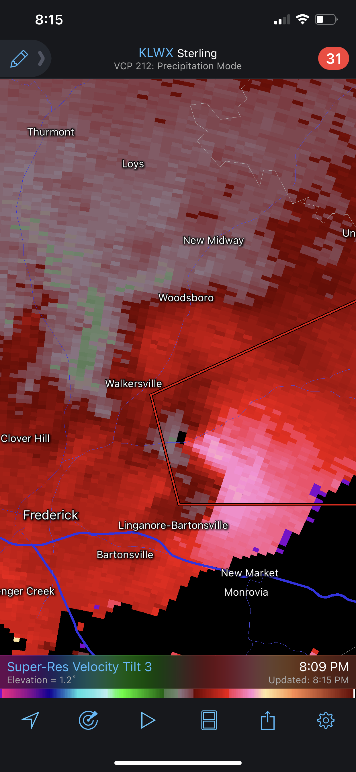
Looks like more strong storms coming into Frederick. Seems like flooding issues are going to be the hazard now.
-
2 minutes ago, Mrs.J said:
Wow

Yeah it even got the hole in the middle a frame or two later. Too close!

-
1 minute ago, Eskimo Joe said:
You're too far north of the circulation in Walkersville...this is hugging I-70
Yeah I see that on the radar now. Worried about my friend down there.
-
4 minutes ago, Mrs.J said:
Closest MDOT traffic cam up on 15 N
https://chart.maryland.gov/video/video.php?feed=ccffd39d00a000e90056fa36c4235c0a
So far nothing really crazy up here. Moderate rain, and not much wind.
-
1
-
-
Just now, yoda said:
BULLETIN - EAS ACTIVATION REQUESTED
Tornado Warning
National Weather Service Baltimore MD/Washington DC
740 PM EDT Mon May 3 2021

The National Weather Service in Sterling Virginia has issued a

* Tornado Warning for...
  Central Frederick County in north central Maryland...

* Until 815 PM EDT.

* At 740 PM EDT, a severe thunderstorm capable of producing a tornado
  was located over Frederick, moving east at 25 mph.

  HAZARD...Tornado.

  SOURCE...Radar indicated rotation.

  IMPACT...For those in the direct path of a tornado touchdown,
           flying debris will be dangerous to those caught without
           shelter. Damage to roofs, siding, and windows may occur.
           Mobile homes may be damaged or destroyed. Tree damage is
           likely.

* This dangerous storm will be near...
  Walkersville, Linganore-Bartonsville and Discovery-Spring Garden
  around 750 PM EDT.

Other locations impacted by this tornadic thunderstorm include
Libertytown and Mount Pleasant.
Weeeeee!!!!
-
1 minute ago, WVclimo said:
It’s rocking pretty good here with some loud thunder and strong gusty winds. Temp has already fallen 10 degrees as the rain begins.
Yeah some of the breezes with these storms are chilly.
-
Nice little storm rolling up the valley for Frederick and North. Lots of good boomers and some pretty good rain.
-
11 minutes ago, Kmlwx said:
It truly becomes just a friendlier, less "misery loves company" group for severe. That thread will probably be dormant for a month or more...For now I've just been occasionally peeking at monthly modeling to see what H5 pattern we might see for the warm months.
To me, I think it has to do with amount of buildup or anticipation of winter storms and the nature of winter storms themselves. For severe storms, I think most of us going in know that on any given chance, some get them, most will not. It is what it is. Plus severe chance isn't something you spend nearly as much time tracking and analyzing (or at least pretend to know how to). Just check on it, "cool there is chance" and move on. It is much less of a time/emotional commitment for most I think.
-
1
-


2021 Mid-Atlantic Severe Weather - General Discussion
in Mid Atlantic
Posted
Didn’t see anything up on Montgomery County Fire Twitter yet, so hopefully nothing too serious. Well, beltway is fubur more than usual. That is not a shock though.
It is so incredible how the atmosphere is ready to pop if the right trigger is applied. That line went from nothing to dangerous in maybe 15mins. This is one of those things that draws me to this “hobby”.