

wawarriors4
-
Posts
1,124 -
Joined
-
Last visited
Content Type
Profiles
Blogs
Forums
American Weather
Media Demo
Store
Gallery
Posts posted by wawarriors4
-
-
8 minutes ago, NorthArlington101 said:
where we want it

The ole Fredericksburg Jack that end up a DC hummer……
its nice to look at tho, always just looking for 2” down here around EZF
RR

-
 2
2
-
 1
1
-
-
On 1/16/2024 at 3:25 PM, wawarriors4 said:
12/11/23- 1.3
1/1/24- T
1/15/24- 2.7
Total: 4.0
12/11/23- 1.3
1/1/24- T
1/15/24- 2.7
1/19/24- 1.6
Total- 5.6
-
It's moderate to bordering on Heavy Snow right now in Spotsylvania, but not really sticking to roads. Very pretty though.
-
5
-
-
1.2"
29 with Stray Flakes.
-
6 minutes ago, StormyClearweather said:
Latest from LWX:

PRECIP ALOFT HAS BEEN NOTED ON REGIONAL 88DS AND GPM MICROWAVE
IMAGER OVER THE PAST 6 HOURS ACROSS NORTH CENTRAL AND NORTHEAST
MARYLAND, BUT NO SFC OBS HAVE SHOWN ANYTHING REACHING THE
GROUND AS LOW-LEVEL DEWPOINT DEPRESSIONS REMAIN AT OR ABOVE 20C
PER 19/00Z IAD SOUNDING. NEW SET OF 18Z GUIDANCE DOES NOT SHOW
ANY APPRECIABLE CHANGES TO SPEAK OF ABOUT FRIDAY'S FORECAST.

STRONG SHORTWAVE-TROUGH AND ASSOCIATED VORT MAX WILL PASS
THROUGH THE AREA AROUND MIDDAY FRI SUPPORTING STRONG LIFT TO
GENERATE SNOW. HOWEVER, THE SYSTEM WILL LACK DEEP MOISTURE TO
MAKE THIS A MAJOR STORM IN ADDITION TO BEING FAIRLY PROGRESSIVE.
BLENDED TPW PRODUCT SHOWS PWAT VALUES GENERALLY LESS THAN 0.4
INCHES WITH NO SIGNIFICANT AREAS OF HIGHER MOISTURE LIKELY TO
ADVECT IN. FOR BIGGER STORMS, TYPICALLY 0.5 INCH PWAT VALUES AND
HIGHER ARE NEEDED UNLESS IS A SUPER COLD AIR MASS. ALL OF THESE
FACTORS, IN ADDITION, LACK OF A CLOSED 850-700 MB CIRCULATION,
SUGGEST WARNING LEVEL SNOW ACCUMULATIONS SEEM UNLIKELY. OVERALL,
THE FORECAST AND SNOW AMOUNTS SEEM ON TRACK AND WILL REMAIN
UNCHANGED TONIGHT. FCST SNOW AMOUNTS ACROSS THE FAR SOUTHERN
AREAS LIKE FREDERICKSBURG VA MAY BE SOMEWHAT OVERDONE DUE TO
LACK OF MID-LEVEL SATURATION WHICH MAY INHIBIT SNOWFALL RATES.
IT STILL LOOKS LIKE THE HEAVIEST ACCUMULATIONS OUTSIDE OF THE
MOUNTAIN AREAS WILL OCCUR ALONG AND NORTH OF THE I-70 CORRIDOR
WITH UP TO A FOOT POSSIBLE ACROSS THE APPALACHIAN REGION.
HEAVIEST ACCUMULATION IS EXPECTED IN THE 13Z-19Z FRI TIME FRAME.
Boo on the part about mid-level saturation around FXBG, but it all seems reasonable. Maybe we’ll get lucky.
-
Stafford County Schools, 2 HR Delay with a reassess at 6:30 AM
Patiently waiting for Spotsylvania County Schools........
32/17
-
1
-
-
33/18
-
2 minutes ago, NorthArlington101 said:


I like the "tongue" of blue that comes down and touches the FXBG area.
-
2
-
-
It's certainly an interesting change of events that has seemed to bring my area (around FXBG) back in the game a bit. I won't fully believe it until Snow is falling, but the trend is there. Cautious optimism for Snow on Snow....
-
2
-
-
12/11/23- 1.3
1/1/24- T
1/15/24- 2.7
Total: 4.0
-
Pretty much stopped here around Fredericksburg, blah
-
1
-
-
Easily the heaviest so far down here around FXBG, right around 2” and coming down nicely, 27 degrees
-
5
-
-
Culpeper and Fauquier Schools Closed if you had them in the 9 leg parlay. Fauquier was first…..
-
4
-
-
27 and Light Snow
-
1 minute ago, H2O said:
Just not doing much here. Radar keeps showing very light returns to my SW. I know I'm being impatient but just stinks to have hours of snow, no accums and people already reporting SN and roads pummeled.
Guess the silver lining is that it IS snowing.
Yeah, feel the same way down here around Fredericksburg.
-
Nothing falling here in downtown Fredericksburg and it’s 33.
Back at the house it’s 28 with Flurries.
-
3 minutes ago, Solution Man said:
We got a good band setting up
Probably some subsidence down here too. Just a few flakes and the sun is actually poking through the clouds….
-
2 minutes ago, BristowWx said:
Where is the short pump jack? C VA cut off is brutal on that
Tell me about it, luckily where I am is still North of the cutoff……for now
-
1
-
-
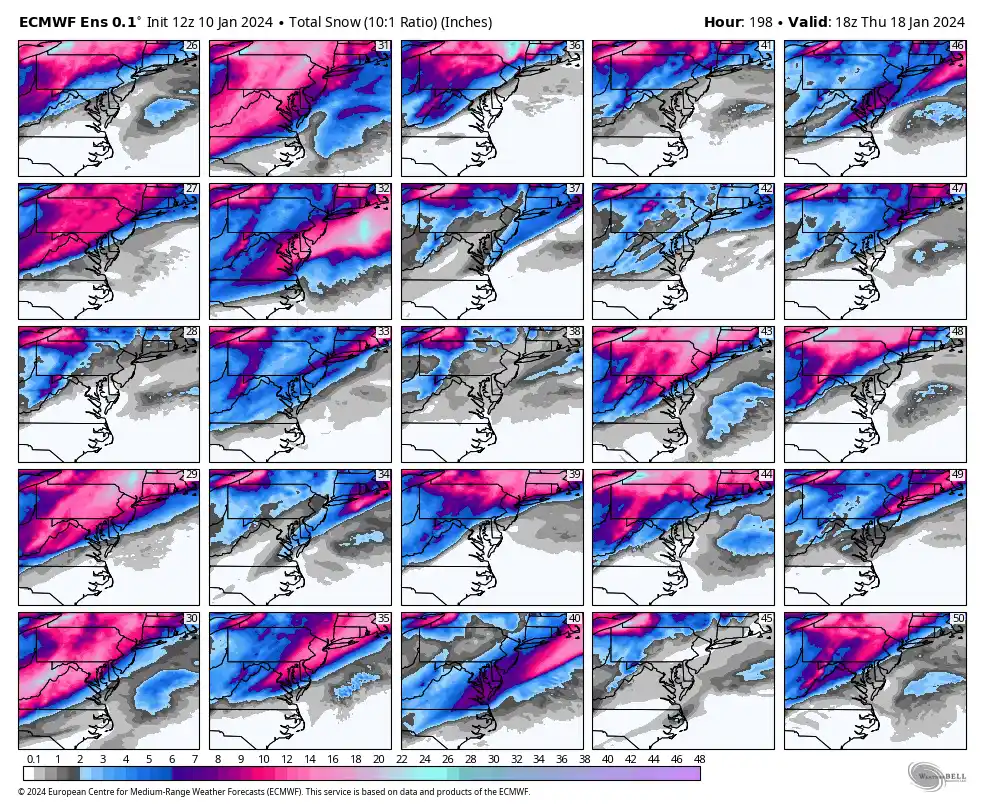
11 minutes ago, aldie 22 said:
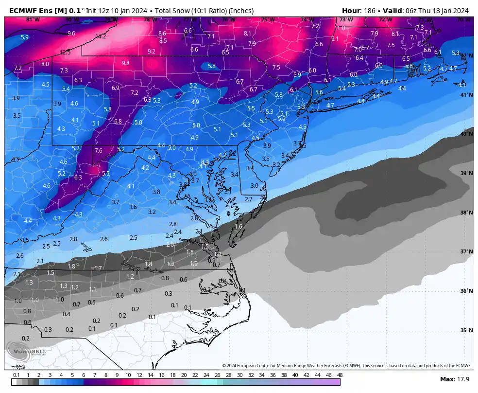
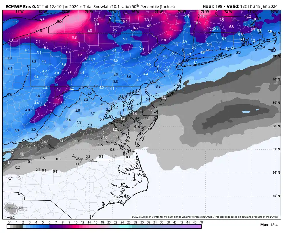
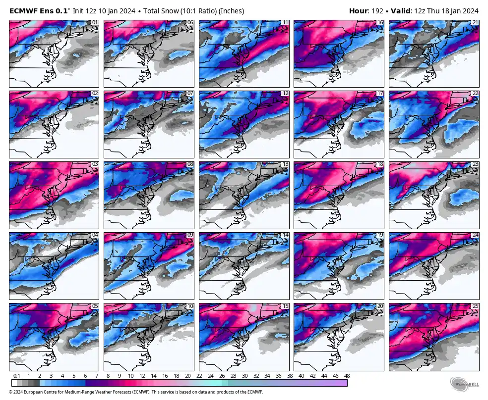
Euro giving the southern crew some love
We usually know how that ends up. Bar is 2”, feel good about that.
-
5
-
-
1 minute ago, WxUSAF said:
I like the way you think
Yeah, except I live 10 miles NE of Fredericksburg,
 but 2” is my bar and that seems doable
-
1
-
-
Just now, WxUSAF said:
Dang, nice run for central VA. Gimme dat.
The Spotsylvania/Fredericksburg bullseye is usually congrats HoCo!
-
2
-
-
-
-
13
-
-
Finished up with 2.86" and the highest wind gust was 44mph when one of the embedded lines came through. Roads all over around FXBG are closed, lots of standing water everywhere.
2024 Severe Weather General Discussion
in Mid Atlantic
Posted
https://x.com/NWSSPC/status/1779973494102720939