

lee59
-
Posts
2,505 -
Joined
-
Last visited
Content Type
Profiles
Blogs
Forums
American Weather
Media Demo
Store
Gallery
Posts posted by lee59
-
-
Central Park will end up with a February average of 40 degrees. It is the only major recording station in the entire area that will end up with a 40 or higher. Also the only station with a seasonal snowfall, so far, below 10 inches.
-
14 minutes ago, Rjay said:
2 days ago
Still had some snow here on Thursday, yesterday took care of it.
-
32 minutes ago, psv88 said:
Nah. The heat island in the 5 Boros has pretty much remained the same since the 1960s. It’s not like there were vasts tracts of open farmland in queens that were developed since 2000…the square mileage of concrete development has probably been nearly identical for the last 50 years.
Yea the heat island has been a factor for years, I just wonder with all the new construction and many new skyscrapers, it may be more pronounced than ever. The fact that Kennedy has colder winters than Central Park and Laguardia may be telling. I don't believe that was the case in the past.
-
Since 2000 the average DJF winter temperature is lower at Kennedy than at LaGuardia and Central Park. Considering Kennedy is right on the Atlantic Ocean and the other 2 are not, I believe it shows how much the heat island affect has taken hold.
-
 1
1
-
-
16 minutes ago, donsutherland1 said:
With little or no additional snowfall likely in New York City through the remainder of February, the probability that Central Park will see its first case of two consecutive winters with less than 10.0" seasonal snowfall has increased. Below are the numbers for select snowfall amounts through February. The highlighted row indicates where Winter 2023-2024 will very likely stand when February concludes.
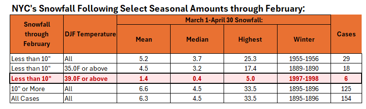
If I am not mistaken only Central Park is below 10 inches. All other city locations are above.
-
3
-
 1
1
-
-
3.75 inches here, maybe 4 with some compacting.
-
About 9 or 10 here this week. About 11 or 12 for the season.
-
3.5 inches of snow here.
-
1
-
-
Got down to 19 degrees here last night.
-
Already dipping below freezing here.
-
About 6 inches of snow here, seems to be a general 4-8 across Long Island.
-
1
-
-
About 4.5 inches here.
-
1
-
-
Snow plows are out in Central Park. Apparently near 3 inches there.
-
1
-
-
Looking at NYS thruway cams, from around Kingston north very little if any snow. Meanwhile not far away to the southeast and southwest numerous inches.
-
1
-
-
Actually had a plow go down my street, been a while.
-
These maps are showing 10-1 ratio, probably would be more like 7-1. So I would adjust accordingly.
-
I think a good call, at this point, for Long Island is a general 3-6 inches.
-
Looks like a potentially good storm track early next week and once again no real cold air to go with it. Meanwhile 26 degrees here this morning.
-
How's this for a forecast--- (high elevations of the Sierra Nevada north of Tahoe)
Snow showers likely, mainly after 2am. The snow could be heavy at times. Patchy fog after 3am. Otherwise, mostly cloudy, with a steady temperature around 22. South wind 6 to 11 mph becoming east 13 to 18 mph in the evening. Winds could gust as high as 21 mph. Chance of precipitation is 70%. Total nighttime snow accumulation of 4 to 8 inches possible.SundaySnow showers. The snow could be heavy at times. Patchy fog before 8am, then areas of fog after 5pm. High near 32. Windy, with an east wind 20 to 30 mph becoming south 36 to 46 mph. Winds could gust as high as 65 mph. Chance of precipitation is 100%. New snow accumulation of 15 to 21 inches possible.Sunday NightSnow showers. The snow could be heavy at times. Areas of fog between 9pm and midnight. Low around 26. Windy, with a south southwest wind 44 to 55 mph, with gusts as high as 75 mph. Chance of precipitation is 100%. New snow accumulation of 14 to 20 inches possible.MondaySnow showers. The snow could be heavy at times. High near 30. Windy, with a south southwest wind 21 to 31 mph, with gusts as high as 43 mph. Chance of precipitation is 90%. New snow accumulation of 8 to 12 inches possible.-
4
-
-
Some might find this interesting in these boring weather times:
https://www.wunderground.com/cat6/US-Snowfall-1900-2019-Decade-Decade-Look
-
2
-
-
10 minutes ago, IrishRob17 said:

From what I read, the average sea ice extent this year is ahead of the 2010s average. Not saying it will stay that way but at least it is a little positive news.
-
1
-
-
Well at least Arctic Sea Ice extent is doing better this year. (relatively speaking)
-
1
-
-
7 minutes ago, Dark Star said:
? Most of any future precip will likely retrograde back from the north?
Yea it is heading east. If it holds it may eventually head northeast and hit eastern New England but will probably just go harmlessly out to sea.
-
March 2024
in New York City Metro
Posted
Did you ever see a forecast like this?
Sierra Nevada north of Tahoe