AfewUniversesBelowNormal
-
Posts
4,753 -
Joined
-
Last visited
Content Type
Profiles
Blogs
Forums
American Weather
Media Demo
Store
Gallery
Everything posted by AfewUniversesBelowNormal
-
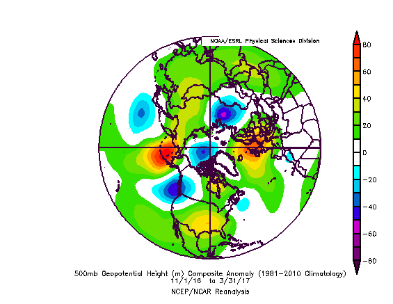
 Another note is that the La Nina in Pacific is setting up more east-based, or subsurface based vs surface. Now with a +500dm+ block in the North Pacific in the next few days, it's starting to move in the direction of more favorable Winter pattern (cold), -NAO/-AO long term pattern Winter. 95-96 is a decent analog.
 -
Good signs happening now. Models bring back -NAO beyond day 10 and the general momentum of pattern is supportive of "-NAO lock" for the Winter.
-
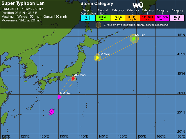
Vera was the strongest typhoon to ever hit Japan, Cat3 https://en.wikipedia.org/wiki/Typhoon_Vera Much different path, this one. Beyond that, 30% of Japans population is at projected landfall in maybe the best angle possible for maximum impact.
.gif.126564fcc3935bb375cee8bda80401aa.gif)
-
I never really expected it to be cool. NAO while negative will probably be mostly transitory, which means less snow. It would have been really nice to have a different Pacific right now, -EPO or GOA ridge all month, then with -QBO loading pattern, something cold and snowy is 5x more likely. As it is now, the tendency for Atlantic blocking will often be in battle with forces to shear it out.
-
The way the whole Northern Hemisphere is moving right now feels like a warm Winter to me. Probably Pacific driven.
-
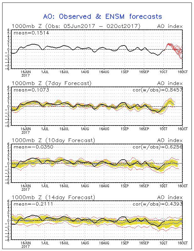
Historically, the inverse OctoberAO-WinterNAO signal ends around October 25, and then there is increasing similarity, peaking around November 20. Pretty text book right here.
.thumb.gif.d97ce6fb7bbdc9f6f4a2265ae09b3078.gif)
-
Hermine shifted 240 degrees in the Gulf. It's early in the season for NHC track
-
re: post
It's just lazy. those things aren't modeled well 5 days in advance vs climatology. They accept average error mark of X and keep doing it
-
Strong La Nina and El Nino historically dominate with a strong Polar vortex, overpowering the -QBO times past, although I don't think this to be true in El Nino in theory. Historically data -1.2 to +1.2 ENSO with -QBO is 60% chance of -AO Winter.
-
QBO-Winter temps correlation is actually weaker than random on 70 years of data. This also applies to with ENSO. re: post above, throw any 6 years together and you'll probably get concentrated anomalies. I get it lure as predictable. QBO has to do with Stratospheric warming, and -QBO generally means more -AO events, although this works better with El Nino.
-
October's AO is 60-65% oppositely correlated to Dec-Feb NAO. Most, maybe all, other months in the year are similarly correlated (maybe one in the Spring was 49%). November is strongest direct correlation. -October/+November is 70%. October is the forecasting stone and it's +AO on models, even where this graph in the long range shows mix.
-
You're right
-
El Nino/-QBO 60% correlated to -NAO La Nina/+QBO 60% correlated to +NAO
-
Interaction signature law of balances states that you can estimate the impact A had on B by seeing what B did to A?
-
Storm is really expanding in size. very symmetrical. back to Cat 4 next 24-48 hours.
-
Becoming more cyclically organized but starting to bias toward the NE side. It's hard to get Cat 5 in this condition. The radar is probably off center or something
-
less weight on Jose, I think. easy model bias identified. Maria is its own beast
-
Check out the SW side of Jose, how it's drying out reaching a calm
-
Only 1 storm didn't hit America, and it was furthest NW of the bunch, soon to be nonanalog. La Nina still being underestimated, I think
-
Around Neutral. I'm using 500mb maps. sometimes Iceland region is considered because that's the northern dipole in SLP. +AO
-
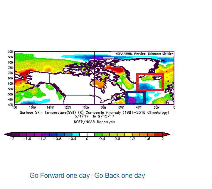
2005 on a site called easternuswx, elaborate research was done with North Atlantic SSTs, showing high lagging predictive value for following Winter's NAO/AO. The correlation factor was higher than 0.4, and there was advantage over decadal cycles. Meaning, it would predict years that reversed the decadal trend. The index was very accurate in predicting the +NAO for the 2005-2006 Winter, and got much attention after a topic called "This will be the warmest Winter on record for the US" (It was 7). Since then the index has performed wonderfully after the fact: 2016-17: Strong - NAO signal/ Weak -NAO Winter .. Yes 2015-16: +NAO signal/ +NAO Winter ... Yes 2014-15: Strong - NAO signal / +NAO Winter ... No 2013-14: Strong +NAO signal / +NAO Winter ... Yes 2012-13: slight -NAO signal / strong -NAO Winter ... Yes 2011-2012 neutral NAO signal / +NAO Winter ... even 2010-2011: Strong -NAO signal/ Strong -NAO Winter ... Strong Yes 2009-2010: Strong -NAO signal / Strong - NAO Winter ... Yes 2008-2009: weak -NAO signal / weak -NAO Winter ... Yes 2007-2008: -NAO signal / +NAO Winter ... No 2006-2007: +NAO signal / weak +NAO Winter ... Yes 2005-2006: strong +NAO signal / +NAO Winter ... Yes 9-1-2 This index as a value forecasting tool is proven high, although the scientific fundamentals are a bit weaker in my opinion. Since so many people have asked me about this in the last few years, I thought it a good idea to make a post. The index is a measurement of May 1 - Sept 30 SSTs in the North Atlantic. It's correlated to following November-March NAO/AO (+6 month lag). The index is a composite of 2 areas in the North Atlantic (blue box - red box). When blue box is cold SSTs, negative NAO Winter. When red box is warm SSTs, negative NAO Winter. For compare, and red box is 65% value of blue box anomaly (so -1 blue +0.65 red is same thing). Visa versa. The index this year is strong -NAO. Top 10-15 negative index of all predictive years going back to 1948 (69).
-
The 500mb pattern is so good to keep it south. Actually, more classic for Gulf coast hurricanes than east coast. I give Maria a 75% chance of hitting Florida or going into the Gulf. Jose remnants less likely to bring it north. (it may not be that strong though unless going really far south)
-
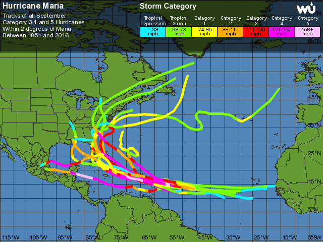
having fun... https://www.wunderground.com/hurricane/atlantic/1999/Hurricane-Jose Analog 1, happened a month later, not as deep. analog 2, westward track from north https://www.wunderground.com/hurricane/atlantic/1998/Major-Hurricane-Georges Hugo, moving west and earlier intensification https://www.wunderground.com/hurricane/atlantic/1989/Major-Hurricane-Hugo earlier intensification https://www.wunderground.com/hurricane/atlantic/1979/Major-Hurricane-David https://www.wunderground.com/hurricane/atlantic/1964/Major-Hurricane-Cleo https://www.wunderground.com/hurricane/atlantic/1963/Hurricane-Edith Best analog: https://www.wunderground.com/hurricane/atlantic/1950/Major-Hurricane-Dog 3 storms since 1935 strengthened rapidly where Maria is expected: Cleo, Edith, Dog (All 7 are ENSO cold cycle times)
-
Maybe if it evolves quickly into a Cat 3/4, a further south track will happen. Nothing in the area at this time of the year has intensified so quickly, moving so far north. Big storms create momentum, and at this is a time of deep cyclones, for some reason, models aren't attuned (example1: Irma went south of Florida entirely, 75% of strong storms do the same thing- go with basic steering patterns vs 500mb influence). I think also there is a Moderate La Nina influence happening right now that is mostly being missed.
-
Has anyone considering plotting 9 planetary +1 moon position in the 360 sky, include angles to each other, versus World weather, also +++ so many days, going back as far as satellites have been plotting data? it would be over ten thousand variables. Could be awesome. I would do it with fast software. You could go forward 1000 years

.gif.963ccda40202cafb681806e619711609.gif)