
.JPG.79118a3ad1baaeec7c8450bdb03170d6.JPG)
BuildingScienceWx
-
Posts
419 -
Joined
-
Last visited
About BuildingScienceWx

- Birthday November 1
Recent Profile Visitors
2,751 profile views


-
.thumb.JPG.2bd630d433431c2d70127e61eb8caf4c.JPG) I would've bet serious amounts of money at terrible odds 24 hours ago that there would be no chance that Dover DE received more digital snow than Worcester in any model run leading up to this event...
I would've bet serious amounts of money at terrible odds 24 hours ago that there would be no chance that Dover DE received more digital snow than Worcester in any model run leading up to this event... -
Your bet with Seymour Snow isn't looking good...
-
Doesn't appear to be much. My place in VT (West Dover) is currently sitting at 29.8F. Precip from here on out is spotty at best.
-
Bethany has a few roads in the northern section of town over 800'. I lost a bidding war to one of the houses at 820'...
-
I thought this was pretty well modeled by the HRRR up until 7am or so when the radar should light up again with the deepening low to our south.
-
I thought it was a decent improvement, but that doesn't mean much considering where we were.
-
1/9-1/10 Now Morphing to Less-Than-Exciting Power Cutter
BuildingScienceWx replied to Torch Tiger's topic in New England
3.86" of rain. "Pack" wiped. -
1/9-1/10 Now Morphing to Less-Than-Exciting Power Cutter
BuildingScienceWx replied to Torch Tiger's topic in New England
Pouring and roaring outside right now. 1.28" in the bucket. -
1/9-1/10 Now Morphing to Less-Than-Exciting Power Cutter
BuildingScienceWx replied to Torch Tiger's topic in New England
This website is always neat to check out during larger storm wind events: https://earth.nullschool.net/#current/wind/surface/level/orthographic=-73.22,38.76,2507/loc=-78.328,32.585 -
1/9-1/10 Now Morphing to Less-Than-Exciting Power Cutter
BuildingScienceWx replied to Torch Tiger's topic in New England
Starting as snow in our area. No mention of that in the forecast. -
January 6-7, 2024 Winter Storm Obs Thread
BuildingScienceWx replied to WxWatcher007's topic in New England
Wrapping up here. Stayed down in CT for the storm. Pedestrian storm around these parts. 4.1" storm total. Good luck up there to my northeast, though looking at the radar I think you'll enjoy your afternoon. -
January 6-7, 2024 Winter Storm Obs Thread
BuildingScienceWx replied to WxWatcher007's topic in New England
2.1". 30.2 / 29.8. Enjoy that band to our north, looks amazing. Not looking promising to meet out WSW criteria at the moment.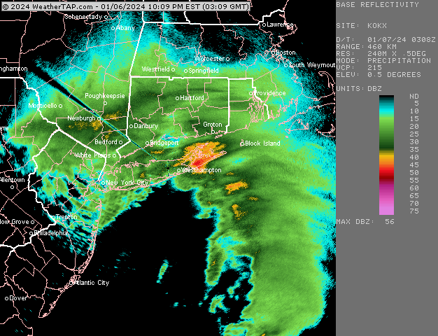
-
January 6-7, 2024 Winter Storm Obs Thread
BuildingScienceWx replied to WxWatcher007's topic in New England
Agreed on the wind. The snow is certainly underperforming here. 1.6" and the temp has increased 1 degree in the last hour. 30.0 / 29.7 -
January 6-7, 2024 Winter Storm Obs Thread
BuildingScienceWx replied to WxWatcher007's topic in New England
1.1". 29.1/28.8. Went through some moderate to heavy bands, snow growth isn't terrible, but it isn't great.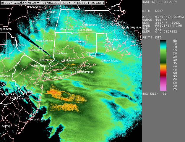
-
January 6-7, 2024 Winter Storm Obs Thread
BuildingScienceWx replied to WxWatcher007's topic in New England
Moderate snow. 0.5". 29.1 / 28.8. 35-40dbz band about to roll through.

