hawkeye_wx
-
Posts
5,925 -
Joined
-
Last visited
Content Type
Profiles
Blogs
Forums
American Weather
Media Demo
Store
Gallery
Everything posted by hawkeye_wx
-
We are currently getting our first light snow of the season as a weak wave moves through ahead of the main system. Regarding the main system tonight, some of the models this morning are a bit wetter and north, so we could get a couple inches.
-
It's looking good for our first snow of the season Saturday night into Sunday morning. We might be able to whiten the ground just a bit if the northern models are right.
-
I still have several pots of flowers outside because it has been so mild (I put them in the garage during cold nights), but it certainly appears my garden season will fully end next week. I need the neighbors' oak tree to start dumping its leaves so I can collect them before the arctic blast arrives.
-
A couple small cells early this morning quickly dropped another 0.37" here. My weekly total is up to 1.98". My October total is 5.14", more than the last three months combined.
-
Today's system performed well for southeast Iowa. One cell produced the heaviest rain I've seen in months, and everything together added up to 1.50". Parts of Iowa, especially out west, experienced a major model bust this week, but, thankfully, today salvaged it for us. For days, models had this system stronger and farther nw, but the last-minute weaker and southeast trend benefitted us.
-
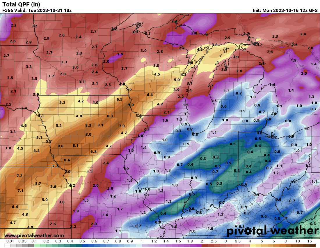
This week is not looking nearly as good as it did a few days ago. The first three waves of rain will be a bust as they miss north and south. The Thursday rain could be ok, but likely not great. The weekend system may end up pretty strung out and south. Models had, unanimously, been predicting widespread 2-3+" across Iowa through the weekend, but many locations in a band through the middle of the state may struggle just to get an inch. 2023 strikes again.
-
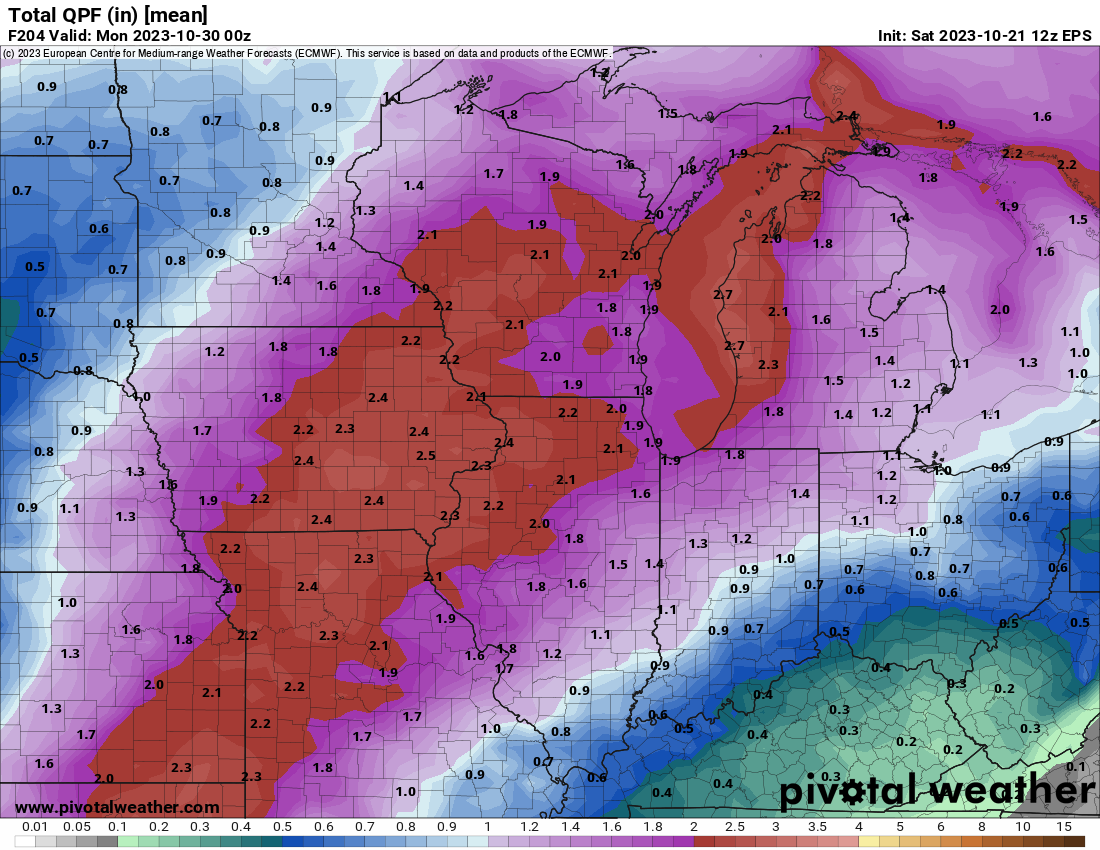
Next week's rain on the EPS. The GEFS and other models are similar. This comes from several rounds of rain, from Monday through next weekend.

-
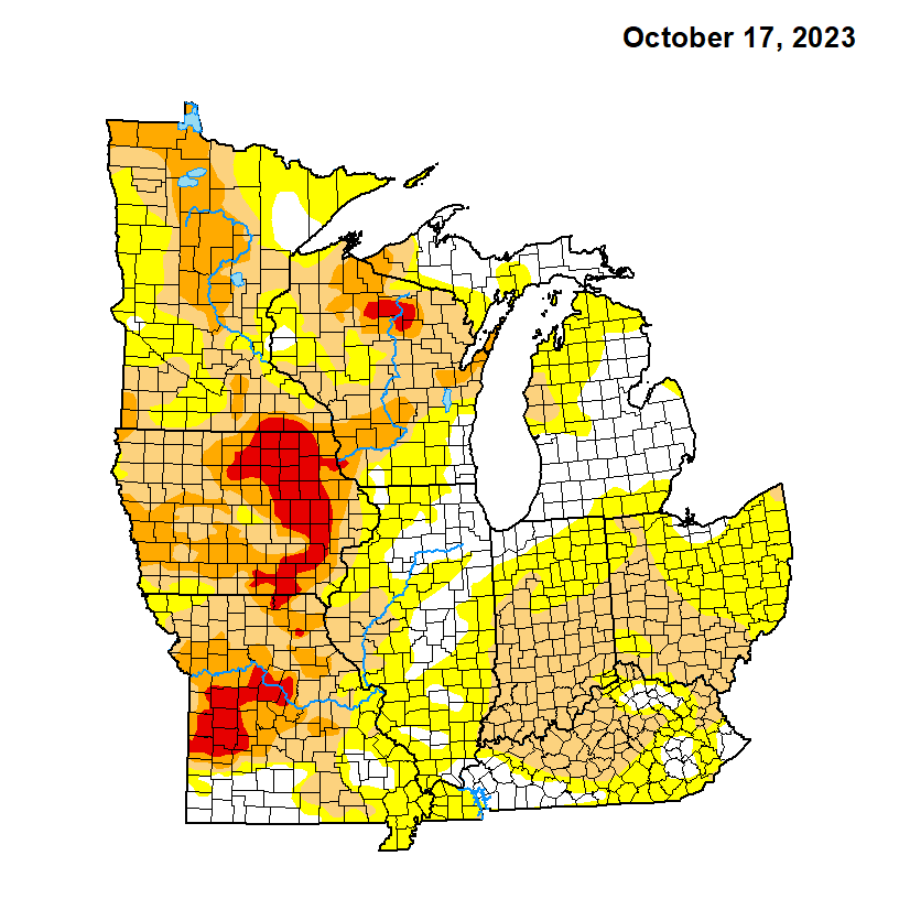
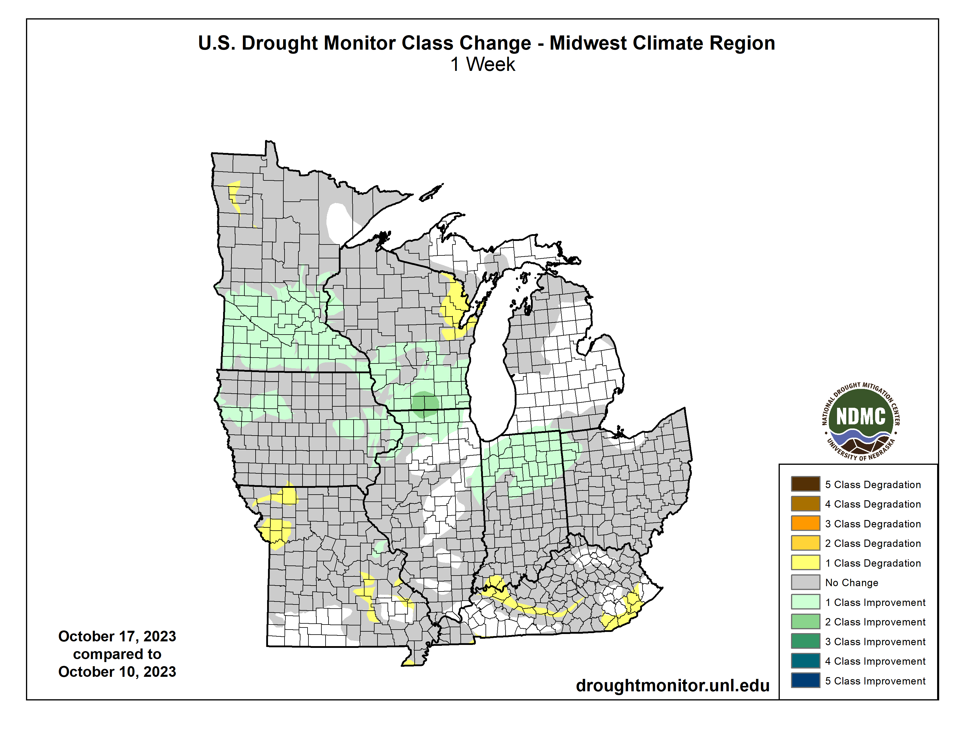
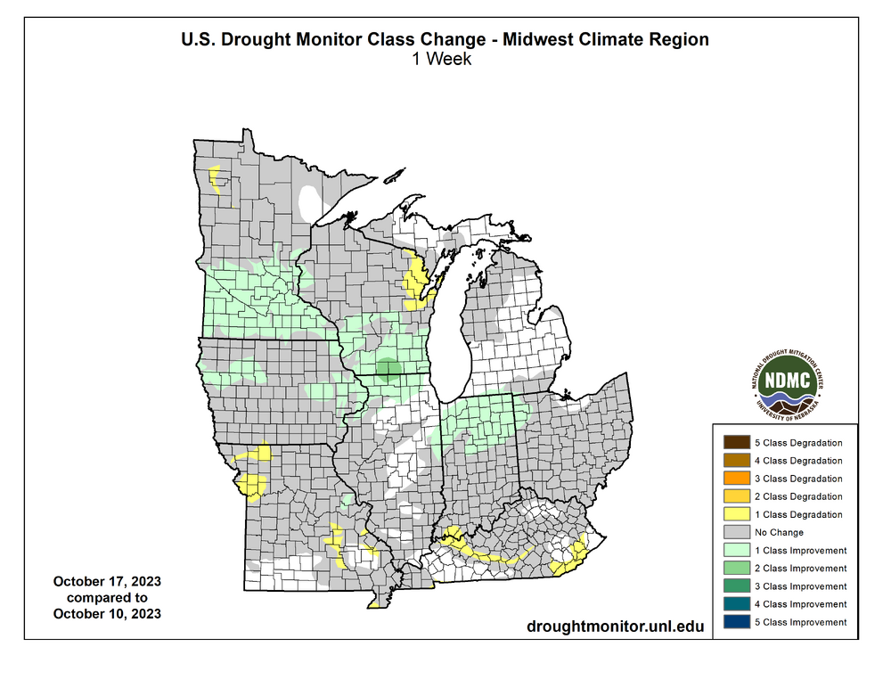
As expected, the latest drought map shows improvement where last week's heavy rain fell. The exceptional drought in the Cedar Rapids area is gone. A couple more good rain events are needed to chip away at the severe drought area.

-
One can dream. 12z GFS.... deep western trough, stalled front, multiple tropical systems getting pulled in.

-
Where can I find that site that has multi-day Cocorahs precip maps?
-
Another 1.17" last evening/night boosted my Wed-Fri total to 3.06". This is, by far, the biggest precip event of 2023. The drought has been so bad, 3.06" easily beats any MONTH since March. Personal stations only a mile west and a few miles north of me got 4.00-4.50". We still have a long way to go to end the drought (still -10" since May), but this is a great start.
-
I'm at 0.58" today (1+" only a mile west of me) and 1.89" since Wednesday. More good rain is moving in now and should total another half to one inch.
-
I only got 0.22" from the cold front this morning. The rain just didn't come together in time for us. However, models show a band of heavy rain developing north of the low this evening as it moves through southeast Iowa. All models have at least one inch here. This system has been a huge bust for southern Iowa. Ottumwa is 15 inches below avg this year and they are getting nothing out of this. For a week models painted 1-3" across the entire state.
-
My total is 1.24". It is unclear how much more rain we will get tomorrow. Models have really delayed the firing along the cold front. Cyclone should get another inch from that Friday morning, but I might not get much. Then, as the low moves through Iowa a secondary defo zone will fire up and drop heavy rain somewhere, but models are all over the place with that. The inch we got was much-needed, but another inch on top of that would be great.
-
This is officially my first 1" rain event since early May. My total so far is about 1.15". There are some 2" totals on the north side of Cedar Rapids.
-

2023 Short/Medium Range Severe Weather Discussion
hawkeye_wx replied to Chicago Storm's topic in Lakes/Ohio Valley
Some potent cells with hail have popped over here. Hail up to 1.50" has been reported. -
A low level jet is expected to fire up the warm front tonight from eastern Iowa through northern Illinois. The question is where, exactly, the heavy band will be. Some models hit Cedar Rapids while some are north.
-
Lidia's pressure is down to 950 mb.
-
The forecast was 35º for a low, but the airport hit 30º and there is a thin layer of ice on my bird bath.
-
Models are flopping around, but the general trend is way north with the strong mid to late week system. The Euro just jumped an entire state north, shifting the heavy rain from Iowa to SD/MN. The heavy defo band now goes through Duluth.
-
Next week's big storm is still flopping around a bit. The GFS was south of Iowa a couple days ago, but now it has jumped way north and dumps most of its rain over SD/MN. The UK is still south. The Canadian and Euro are in between, hitting Iowa hard.
-
It is still several days away, but models are trending better (both op and ensembles) mid to late next week regarding a potential heavy rain system. The current trend is the big southeast Canada/great lakes upper low backs off a bit and allows the western energy to eject farther north. We really need this to happen.
-
We made it! The exceptional drought has expanded over Cedar Rapids. This is officially the worst drought this century. 2012 was worse over a much bigger area, but it has never been this bad in the Cedar Rapids area, specifically.
-
The 00z Euro really digs in the southeast Canada/great lakes upper trough this weekend through next week. The entire 10-day period never gets out of the 50s to low 60s around here. Summer is over.
-
As expected, zero rain here overnight as the line vanished. The next chance that won't pan out is about nine days away. The wet season is waning, but October still averages 3" here. However, at this point it just feels impossible, like we are living in a desert in between mountain ranges.