hawkeye_wx
-
Posts
5,921 -
Joined
-
Last visited
Content Type
Profiles
Blogs
Forums
American Weather
Media Demo
Store
Gallery
Everything posted by hawkeye_wx
-
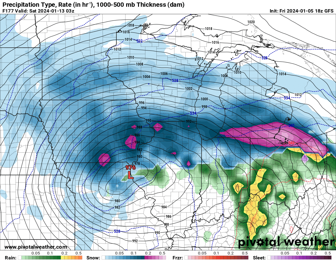
It's probably safe to throw the early NAM runs in the trash. The global models are much farther south with the upper low.
-

Winter 2023/24 Medium/Long Range Discussion
hawkeye_wx replied to Chicago Storm's topic in Lakes/Ohio Valley
The potential of the late-week storm is big. The 18z GFS 500 mb setup is phenomenal and shows what would be the greatest storm on record for Iowa. Cedar Rapids has had its worst flood ever and worst thunderstorm ever in the last fifteen years. It is way past time for a powerful blizzard.
-
Winter 2023/24 Medium/Long Range Discussion
hawkeye_wx replied to Chicago Storm's topic in Lakes/Ohio Valley
Yesterday the Euro had this strong system hitting Minneapolis. This morning it's Oklahoma to St. Louis. Models appear to have very little grasp of this system for now. -
Winter 2023/24 Medium/Long Range Discussion
hawkeye_wx replied to Chicago Storm's topic in Lakes/Ohio Valley
The Tuesday system is looking like it may be a dud for us, but late next week into next weekend looks much more promising. -
I finished with a very solid 1.00" of rain. My December total is 2.01".
-
I picked up a decent 0.32" today. The big system Sun-Wed was looking good for another 2" here, but a westward shift has pushed the heavier rain into central Iowa. I'm hoping for an inch.
-
To be honest, as much as I love heavy snow, this December has been pretty nice. No blowing or back-straining shoveling, no bundling up, can wear Crocs outside, etc. I actually kinda liked yesterday's light rain event. Sure, I'll geek out the next time a big snowstorm approaches, but if this continued all winter, I would not hate it. I guess this is what happens when you approach 50 years old.
-
Yesterday's system put 0.33" in my gauge.
-
You guys have a good memory. I can't remember any weather events before high school (I'm 49).
-
Hit 55º here today. It was very nice and I was able to get more garden prep done. Tonight's rain looks pretty meager, probably just enough to wet the pavement.
-
I recorded 10.5". Sadly, there has not been a single 6-inch snow event, in December + before Xmas, since that 2009 storm.
-
You should watch Eric Snodgrass's daily videos (Nutrien Ag Solutions). He's great. He knows his sh*t and has good presentation skills. I'm not sure how detailed he will get once we start getting big winter storms, but he is based in Illinois so he has a lot of interest in our area/region. Snodgrass YouTube link
-
About an inch of wet snow fell here last night and this morning, so I'm up to 5" this season.
-
Winter 2023/24 Medium/Long Range Discussion
hawkeye_wx replied to Chicago Storm's topic in Lakes/Ohio Valley
Just a day ago models were cutting off a big upper low in the southwest US. Today they are shooting the energy eastward through the midwest. We'll likely see it flop all over the place through mid next week. -
I really don't mind a warm first part of December. I still have garden prep to do and last week's surprise 4" of snow put that on hold. Most of the snow is gone, but I'm waiting for the rest to melt.
-
Today's wave is a bust, snow-wise. It's weak and it's too warm.
-
The deeper-than-expected snow has really cratered the temp early in the week. A few days ago, the early-week highs were going to be in the 30s. Instead, we are struggling to get out of the teens. Tonight we are expecting single digits. We haven't risen above freezing since last Thursday. I still have some garden and garage winter prep to do. It will have to wait til we thaw out.
-
This system exceeded the model predictions. I finished with a real nice 4.1 inches of snow from 0.34" of liquid. The heaviest snow fell in the 3-4am period, when I was asleep, but some decent fluffy stuff lingered after sunrise. Just a couple days ago this was looking like a weak nothingburger, maybe up to an inch in spots.
-
Two consecutive days below freezing, combined with overnight timing, should aid the accumulation.
-
All models today have shifted north and wetter, so DVN has expanded the advisory up through Cedar Rapids. We could get up to 3 inches.
-
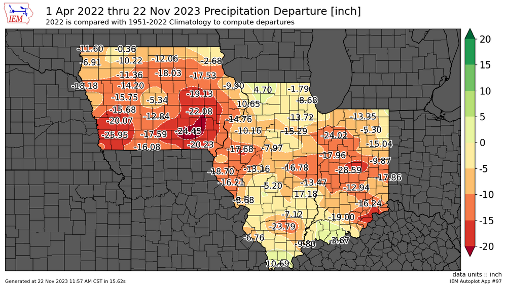
Terry Swails posted this in a recent blog post. Southeast Iowa is now 20-25" of rain below average since April 2022. Thanks to a couple big rain events in northern Illinois last summer, there is a near 30" difference between Ottumwa and Rockford.
-
We are currently getting our first light snow of the season as a weak wave moves through ahead of the main system. Regarding the main system tonight, some of the models this morning are a bit wetter and north, so we could get a couple inches.
-
It's looking good for our first snow of the season Saturday night into Sunday morning. We might be able to whiten the ground just a bit if the northern models are right.
-
I still have several pots of flowers outside because it has been so mild (I put them in the garage during cold nights), but it certainly appears my garden season will fully end next week. I need the neighbors' oak tree to start dumping its leaves so I can collect them before the arctic blast arrives.
-
A couple small cells early this morning quickly dropped another 0.37" here. My weekly total is up to 1.98". My October total is 5.14", more than the last three months combined.