

FLweather
-
Posts
2,419 -
Joined
Content Type
Profiles
Blogs
Forums
American Weather
Media Demo
Store
Gallery
Posts posted by FLweather
-
-
Judging by satellite. The fact it's been wobbling so today.
I honestly would not be shocked if Ida makes landfall west of Mobile Bay right into lower MS.
Especially if it under goes more strengthening since the sun has gone down.
-
 1
1
-
 1
1
-
 9
9
-
-
Looking at WV. West of the keys Sarasota Tampa and the big bend of FL looks as if a low level jet/convergence band setting up.
-
10 minutes ago, Eskimo Joe said:
Going to go out on a limb and say Ida fights pockets of dry air that prevent it from achieving Cat 4 or 5 status. It's running out of time before it begins interacting with the continental airmass. I'm very interested to see if any buoys get close to the center tonight and see what the wave height and winds are. Would give us a clue as to the potential storm surge.
Say what?!
Looking at Visible.. there is a deep SE flow for most of the SE at the surface. Including LA, MS, TX.
Any influx of continental airmass would be coming from the SW of the Storm through Mexico up through the BOC and that's not really happening.
-
 1
1
-
-
Judging by WV Ida's convection waned some over the last few hours. But she is wrapping up.
Not good.
Now that sunset approaches. Give it a few hours for the upper levels to cool off... No telling what might happen.
-
 1
1
-
-
The eye of Ida is expanding over the last few frames. Convection has waned as well from IR and WV.
-
Looks like Ida finally opening up a eye via WV. A small one atm.
Towers continuing to build N,E,S of the center.
-
Via WV... Ida is becoming highly symmetrical around the center and all quadrants.
Very obvious that Ida gaining some steam this morning.
-
8 minutes ago, Iceresistance said:
I did not expect this at all . . . Powerful convective burst over Cuba

Not really shocking.
Considering the LLC coming into a mountain/hill chain... Strong south flow. There will be orographic enhancement.
-
3
-
-
8 minutes ago, turtlehurricane said:
Thank you, I sensed there was some complex interaction going on between TD 9 and the disturbance that crossed Florida last night. Both systems flared up simultaneously, and they seemed to be attached from the beginning.
I think the upper-low feature deepened more than expected, thanks to the plethora of deep convection it was producing, leading to a far weaker steering ridge.
It seems Ida is coupling with the poleward current on the east side of the upper-low, indeed Ida's outflow is spreading north at incredible speeds, and has crossed the Florida Straits in just a few hours. I can actually see Ida's outflow cirrus from my balcony right now.
This divergence will help Ida to quickly intensify, and convective development is biased towards northern semicircle too, both of which are factors that will push Ida north and east of track.
With all due respect.
You're a meteorologist... You should know these things.
Unless getting met degree was on your bucket list of things to do but you have never really practiced that education.
Ya awfully rusty charlie.
But no disrespect intended.
But agree. Darn good outflow to the north and south of the center.
As long as the LLC stays away from land to minimize friction. This storm could look a lot different in the morning. Especially since the upper levels cool off after today's sun.
-
1
-
-
Looking at WV. Not much left of Henri. Probably won't be much left over the next several hours.
Pretty much been fully captured by the H5 trough.
-
Here is the next few to several hours.
Won't be anything left of Henri.
H5 trough absorbing the storm.
Which there is nothing really left of it now.
-
1
-
-
49 minutes ago, Prospero said:
We had one band here in Pinellas County come through today after passing by for many hours offshore; maybe 15 or 20 minutes of sideways rain and winds around 20 mph, but nothing big except the visuals that creates like flooded parking lots and swaying palms that seemed to possibly be exaggerating a little..
Our temperatures around here have been less than the ocean the past two days, so it appears the band came over land and lost its fuel and faded out quickly.
Yeah it looked threatening all day in Clearwater. Then went to a new upcoming job by the hard rock casino.
It held that look for the biggest part of the day. Around Lakeland ran through some sprinkles. Just enough to cut the wipers on.
But considering the orientation I was expecting something over the peninsula. At least with such deep SW flow.
-
1
-
-
Honestly considering the direction of the storm I expected much more squally bands with afternoon heating.
But the outer bands have been minimal down the FL peninsula today.
With such deep SW flow, ECSB is not there. Neither has the meso boundaries.
High clouds have prevailed
-
1
-
-
I'm over here in Tampa on my way to Clearwater. But you can certainly tell there is a storm in the GOM.
Very dark and the bay is choppy.
-
1
-
-
What a eye on Linda. Highly impressive.
-
With the h2 trough over GA and FL. Plus the HP currently over top of Fred.. Alot of divergence available atm coupled with Diurnal max.
Clearly seen on WV as clouds back to the NW with the developing jet.. Fred trying extra hard tonight.
-
What a flare up of convection last couple of hours.
No dry air to really be found on WV of any significance.
H2 trough visible over GA,FL.
With the diurnal convection developing atm and possible further favorable upper level divergence developing... Fred could get his act together tonight.
Outflow looks decent to the North, East and South
-
10 minutes ago, Prospero said:
May I ask?
Have you ever experienced a tropical cyclone (Tropical Storm or Hurricane)?
If not, even a moderate Tropical Storm will be something you'll never forget. The sustained winds, pounding sideways rain, the surf breaking and blowing over seawalls, palm fronds flying in the air, power going out, etc.
For we who live down here in Florida who have homes and businesses that we cannot pack up and run away during a storm, we ride them out. For chasers who are mobile, even the worst hurricanes you can "get out of the way" in a reasonably short notice, even in traffic on bridges.
So you should aim to be in the heart and core of whatever Fred might do, and if two or three hours out it looks really bad (cat 3 or 4), head inland or a few miles north or south. You likely won't be in danger unless you are foolish and ignore the obvious. But you won't need to worry about that with Fred, I am confident. Try to be where it will be the worst, get your money's worth on your trip to Florida. No matter what, chances are you will not be in the exact right place.
That said, even being anywhere in a tropical cyclone is very impressive. You will "feel" it, these storms have a feel that is unique. The awesome power is not like anything else in the world. Watching clouds overhead move quickly, the wind on your face, the palms bending (which they evolved to do), everything is amazing. Enjoy!
Side note on my previous whiny email about not getting rain in Gulfport. We are getting it this time, sideways. Third night of crackling lightning and thunder, a 60 mph gust recorded and mentioned on the local news. (My dad in assisted living a couple miles away just called panicking thinking Fred was here! LOL)
Uh oh, power blinking again. Been a few years since we've lost power, and the past three nights our areas has been out. Debris in the yard which is good as it helps to prepare the trees for a storm IF we get one.
")
I'll be out your way tomorrow working off of McMullen Booth RD and Gulf to Bay.
But coming across SR 60 across the bay... I would be really sketched out if a cat 2 or higher hit that area.. presuming the NE quadrant.
-
1
-
-
25 minutes ago, Prospero said:
Fred's not dead. Maybe beat up a little.
One can make out a little circulation on the IR animation. It may not be directly over the LLC though.

That's not the LLC. Move your arrow to the left over that island.
That's where the LLC is.
That area with your arrow is probably more than likely is the MLC.
-
Wow. Talk about a junky system.
LLC highly displaced from any convection.
Currently over that little island NNW of Haiti.
While convection and upper levels trapped over Hispaniola. I honestly don't see this system getting it's act together. Considering the LLC out running the upper levels.
-
8 minutes ago, Prospero said:
Especially if the center is more on the north side of Hispaniola which it might be.
Part of my frame of reference is when a low fed by monsoon or Gulf moisture hits southwest Colorado and snow piles up very deep on the front range fairly far away from the center of the low. So the convection on the southern side of this island's mountains to me could be just the pile up of moisture and energy being squeezed out by the elevation while the center is on the other side of the mountains.
I AM NOT A MET (disclaimer)
I see what your talking about now.
Good eye.
Most definitely that feature could be SFC. If it is... It's about to be over water again here shortly.
-
1
-
-
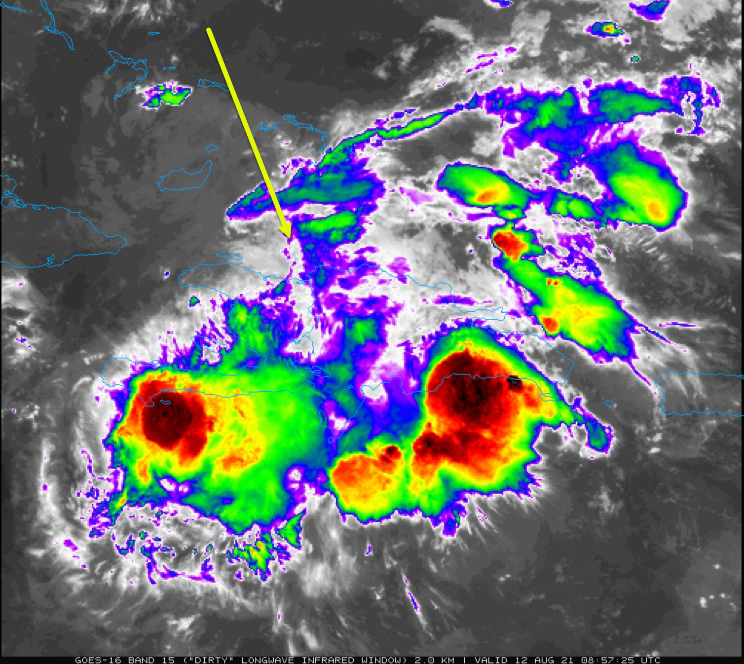
2 minutes ago, SnowenOutThere said:
Looking at that and the storm might be able to ninja it’s way into the bay avoiding the worst of the mountains.
It is.
Not going to run into a brick wall... Mainland Hispaniola.
Going to skim South than probably jump north of there.
-
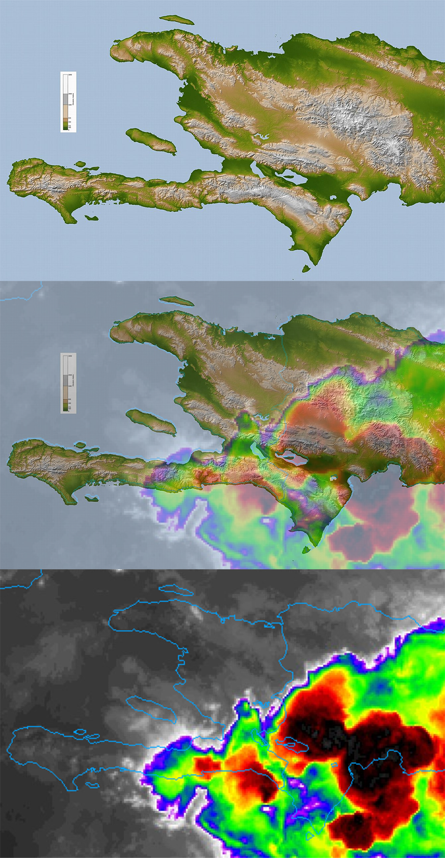
12 minutes ago, Prospero said:
Here's a graphic I just made for myself, not being totally educated on the mountains of the island. The convection is in the valley. But one lesson over and over, and over again the past couple years I have been here is that convection is not always where the center of the storm is. Deceptive way too often.
At this moment I am catching up for the day, yet trying not to fall into the "convection burst" excitement I have typically enjoyed too much. Even seeing an "eye" that seems to want to appear.
")
But the graphic shows the terrain and where the current IR overlays.

Kudos.
-
1
-
-
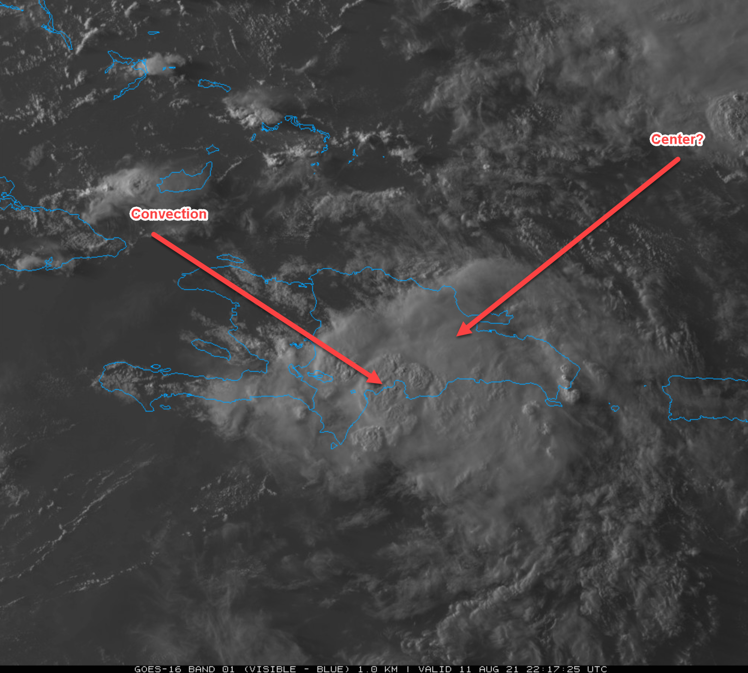
1 minute ago, Prospero said:
OK, can anyone tell us which arrow is closer the whatever is the center?
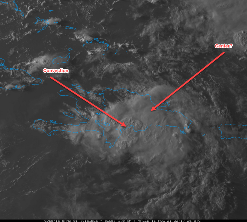
Probably the convection as the SLC scraps and squeezes through 2 valley regions.
Major Hurricane Ida
in Tropical Headquarters
Posted
But probable
Just like everyone saying it's heading to New Orleans.
Models can only do so much. Especially during the fact that you have a TC strengthening.
I can tell you that the current center fix with a strengthening center is already too far east and curving to make landfall in New Orleans.
It's going to be east.