

RogueWaves
-
Posts
2,256 -
Joined
-
Last visited
Content Type
Profiles
Blogs
Forums
American Weather
Media Demo
Store
Gallery
Posts posted by RogueWaves
-
-
Snow on snow (drifts) for me up here. Way to ring in the springtime!

-
 1
1
-
-
On 2/27/2024 at 10:01 PM, michsnowfreak said:
The winter of 1899-00 was crazy. what started as a very lackluster snow season through january (9.4") saw 58" of snow in Feb-Mar, including a snow depth of 26" March 5. While this was going on in southern MI, it was an extremely light winter up north.
Deedler's article stated that in his opinion, the depth likely peaked at 28" sometime in the early hours on the 5th or 6th, but then the SLP curved sharply north running up over KLAN (which didn't exist yet ofc), turning the snowstorm into a +RN event in Detroit dropping the depth by the time they took their official measurements at 7 am.
-
 1
1
-
-
Back when pigs flew
Quote1900, a snowstorm dropped 12.6 inches of snow at Detroit. This was the 7th heaviest snowstorm in Detroit history. It also started a remarkable run of snowstorms that included the 3rd and 4th heaviest snowstorms during the next two weeks in 1900.
-
 1
1
-
-
On 2/3/2024 at 6:06 PM, Lightning said:
How close are you to Mid Michigan College? We have done some road and MTN Biking around there. Nice area!!
I am about 4 miles north.
-
 1
1
-
-
14 hours ago, WestMichigan said:
I never know where you are gong to pop up next. You sure do move around a lot. Welcome back to the GRR forecast area where you can be negelected almost as much as the Battle Creek area.
Not THAT much. I was in Marshall nearly 20 yrs (02-21), then Metro Detroit 2.5 yrs. I could stay here just fine and hopefully will. Middle of the Mitt and basically everything within a few hrs drive (or less).
-
2
-
-
20 hours ago, michsnowfreak said:
When did you move? Was a solid snow month in DTW all things considered.
New Years Eve. Yeah, surprisingly good score for DTW. Big month here as well with 31.7"
-
1
-
-
On 1/30/2024 at 12:51 PM, AWMT30 said:
Well closing with 5.3" of snow here in Canton, Michigan. VERY VERY VERY PLEASED
I guess now that I left Canton, it decided to snow there again. Ofc
-
Solid snow this evening making for another dicey commute. X-way was the worst. Estimating 2-3 inches fell right around 31-32F. Nice to see b4 the warm RN up next. This was a fun stretch considering the ENSO backdrop.
-
3 hours ago, Powerball said:
That's what I arrived home in. Had to stop by the super market and noticed everybody was letting their cars just run and wipers on delay so they didn't have to have a frozen windshield to deal with when they came out. I joined the party and left mine running too. First time for that. So glad I did.
-
1
-
-
1 hour ago, Harry said:
Well for a short bit I felt like I was back east with the heavy snow and big fat flakes..
Hope to score on some fatty's tomorrow/tomorrow evening before the very cold stuff arrives and kills the flake size tomorrow night..
Surprised there is not more talk about the lake effect because it's supposed to go till Sunday at least ( per GRR ) with the winds etc we should see cross state bands that should reach the Detroit area..
APX mentioned we are getting EC style system during this Nino with up to 4"/hr rates with help from Huron. I had 2+/hr here and look to be easily at 8" so far. Backside fluff will likely be the lesser 1/3 of the total, same as with the Tue-Wed system.
-
1 hour ago, SchaumburgStormer said:
NAM caved south. More in line with the euro
Huh?? Not over here.
-
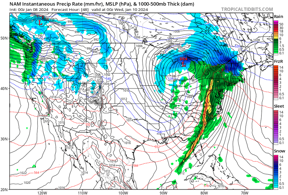
4 hours ago, Imneversatisfied said:
Lastest ECMWF SE shift puts me back into the best snows. Still worried about wind off the lake creating p type issues. Let's see if the next GFS run follows suit. As for slp, pretty remarkable how consistent models have been for a sub 980mb low in the great lakes region for over a week. Now the show really begins.

DTX mentioned that temps aloft may end up 1-2 degrees Celsius lower than expected. It may be just enough to help in some marginal scenarios.
-
9 minutes ago, michsnowfreak said:
It was more historic in the Ohio Valley. definitely a bit of a cold winter here, but snowfall itself was not impressive. There was a decent snowpack.
Perhaps Detroit proper got screwed a bit which seems common with the stronger storms tracking near there, but other areas west in The Mitt were pummeled.
-
2
-
-
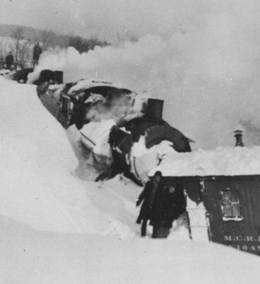
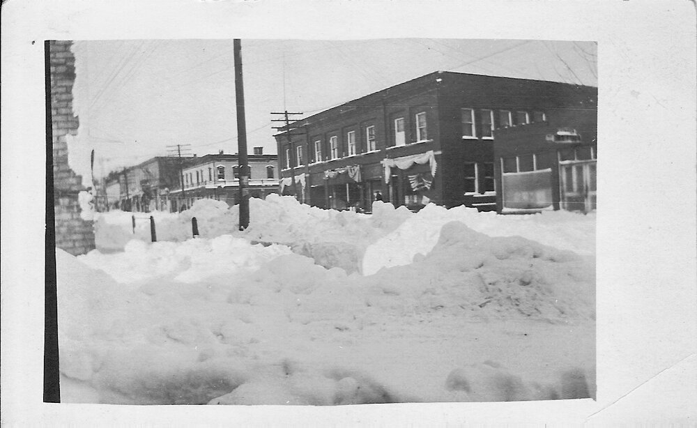
33 minutes ago, michsnowfreak said:
A fierce blizzard. although only 5 inches of snowfall at Detroit temperatures plummeted to −16°.
1917-18 was an historic cold and snowy winter for the OHV/S. Lakes. I think there was a substantial snow pack already when that hit. Much like the 78 bliz, impacts were magnified across SMI and OH. And just like 78, it wasn't forecast to bomb-out to Huron, but to take a more typical path eastward. It also may be one, if not the first storm where rescuing stranded motorists (yes in their state of the art Model T's) was a modern day phenomenon that made newspaper articles.
-
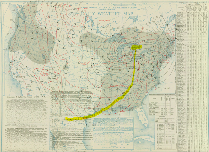
12 hours ago, Roger Smith said:
I looked at all the guidance and wondered if perhaps the eventual solution is a very strong low a bit further east like a Euro track with GFS intensity running up into Lake huron rather than Lake michigan. That would be even more similar to 1-26-1978 and would bring heaviest snow and intense blizzard conditions into Indiana and lower michigan although it would still be an extreme event for IL and WI. Would not be anywhere near 54" of snow for STL, perhaps 10-15", the max snowfalls on my proposed track (at GFS intensity) would be 30-40 inches from about s IL to GRR to n lower michigan. All it takes to shift east is a deeper dive of vorticity into TX and recurve into e/c AR and w KY-s IL then n.n.e., 960 low near LAN instead of GRB.
In weather history, L huron is of course a magnet for deep lows, beside 1-26-78 there was also 11-09-1913, but I suppose if analogs for further west are sought, how about Nov 1, 1991?
Jan 12, 1918 bombed-out from the Gulf states to Huron as well.
-
2
-
1
-
-
19 hours ago, RCNYILWX said:
The CIPS analogs start at hour 132, so the best we can do is CPC 6-10 day analogs. The December 1978 analog had 13" in Chicago the last 4 days of the month.
Edit: Aside from some of the obvious greats, my knowledge of Midwest snowstorms prior to my time here (started in summer 2010) isn't the best. Any other dates stick out on the analog list?
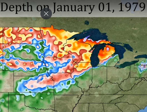
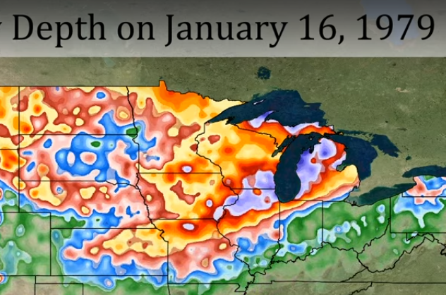
Apparently, the first in that historic series of storms hit right at the end of December '78 as seen by the nice snow cover left on New Years Day 1979. Can't help but notice the similarities with what is happening in this unfolding pattern. The "Blizzard of '79" hit 1/13-14 and was further east so that SEMI was included in the nice accumulations.
-
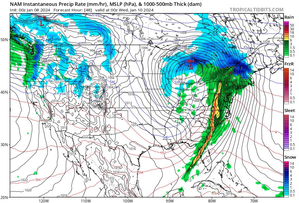
Anyone that can explain this new (to me) phenomenon I bolded, please feel free to enlighten.
GRR
4) Ensemble solutions, particularly the ECWMF Ensemble (ECE),
indicate potential for explosive cyclogenesis as the surface low
tracks toward the Ohio Valley. The ECE mean MSLP has dropped to 980
mb, which would imply that several ensemble member solutions feature
minimum pressures significantly less than that. Not surprisingly, we
are now seeing Shift of Tails (SoT) values in the ECE approaching 2
or greater over parts of Lower Michigan. This means that there are
several ensemble member solutions behaving as extreme outliers
relative to ECE model climatology. This also emphasizes strong
positional sensitivity to the forecast when dealing with what could
be a very deep surface low setting up somewhere.
-
I'm liking this and foresee less extreme wobbles moving forward. Recon input may be helping dial things in sooner.

-
1
-
-
1 hour ago, Chinook said:
What is this purple and pink rectangle at Detroit? A car for the Motor City?
That's the DTW blob of wx BS.
Meanwhile, 16" at my place. Nice!
-
14 hours ago, Harry Perry said:
We are still SO far out - no one should have any expectations yet.
It is nice to finally have something to watch though, and to have weenie maps is pure lust.
Liking where I sit attm
8 minutes ago, Stevo6899 said:It's been years since we've seen a nw trend or a storm actually strengthen to the degree the models are showing. Models have gotten tendencies to over amp storms so anything is on the table, from a sub 980 tracking over chicago to 990 tracking over pittsburgh. Either way this low pressure is impressive on satellite and causing high winds in alaska.
Umm, what was 3/3/23 if not also a strong SLP not going NW last minute?
-
1 hour ago, StormChaser4Life said:
My exact concerns esp with the antecedent temps. Afraid most/all of the front end thump will be rain or mix which will hold back snow amounts some. Looks like dynamic cooling and cooler temps filtering in from nw in the deformation axis will be main if not only player for heavy snow. So we really will need that low to deepen sufficiently to wrap up that deformation band. Regardless could still be a high impact event with blizzard like conditions.
A lot like last March 3rd storm for SEMI
-
2
-
-
20 minutes ago, michsnowfreak said:
This winter is nothing like 2011-12 so far.
Please expand on that
-
For cities not listed
-
1
-
2
-
-
On 12/19/2023 at 7:33 PM, roardog said:
I think the most sleet I’ve ever seen was early April 2003. The previous night was an ice storm while everyone to the south was getting just rain. The next night everyone to the south was getting an ice storm while I was getting buried in sleet. I remember there was at least two or three inches of sleet. It stuck around for a while too even though it was April.
‘83,’03,’07,’16 were all Ninos that had a real wintry period in early April. Will ‘24 join that list?
SWMI's version of that was 12-28, 2015. Looks like odds increase for those events during these Nino's
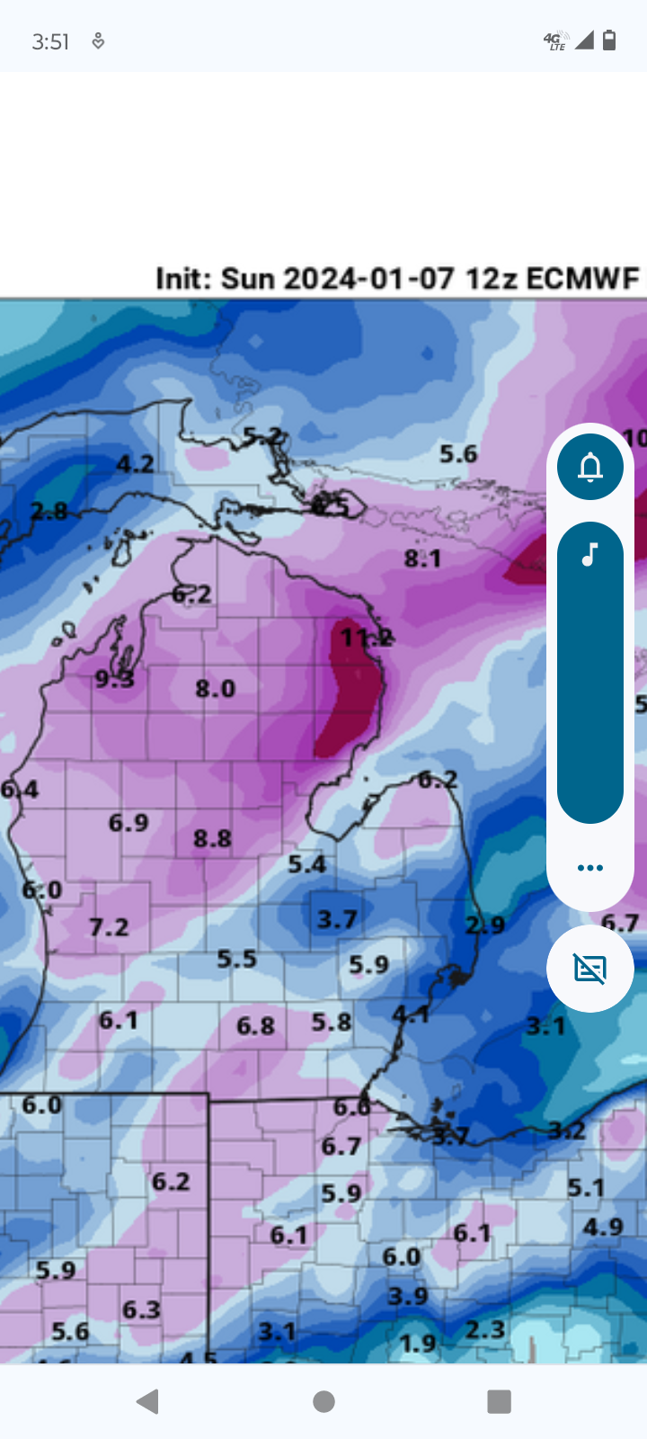

March 2024 General Discussion
in Lakes/Ohio Valley
Posted
It's that guy that rarely reports. I don't think he's on here tbh. Shocking that because I left, Canton out-snowed mby, lol