
NoDoppler4TnySandz
-
Posts
112 -
Joined
-
Last visited
Content Type
Profiles
Blogs
Forums
American Weather
Media Demo
Store
Gallery
Posts posted by NoDoppler4TnySandz
-
-
2.5 - 3" SE Cincy by the river, close to W. Clermont Co line....probably a 6 in total 30-40 miles east of here -- I am sure we all could say that.
-

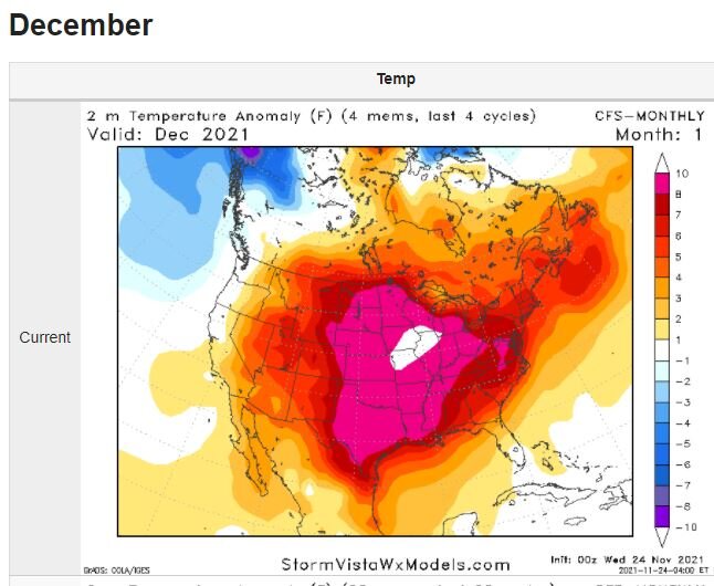
Couldn't get to a post yesterday but have been watching... was going to post about our preferred position given the time to trend NW.... Models inched that way overnight....let's keep it coming in the 12z pkg. May even get Coach more than a dusting up in Darke Co.
-
 1
1
-
 1
1
-
-
45 minutes ago, buckeye said:
If it's not going to snow then I'll gladly take this as option 2
As long as it's dry, DEFINITELY AGREE Buckeye.....load that up at the beginning of the month and swing hard winter the last ten days, even better.
-
1 hour ago, buckeye said:
Looks like the fat lady has approached the microphone for winter 2020-2021. Every indice I've seen is showing a warm signal moving ahead thru March. I might be a little early here but even if we don't see another flake of snow, I'm giving this winter an B+/A-. It's all relative but here are my thoughts,
-Christmas eve/day snow
-Multi-week snow cover
-Avoided insanely cold temps
-Insane block allowed us to avoid cutter city (considering it was a nina winter)
-Yea, I know....what about the sleet storm and what could have been? Oh well, was still our first winterstorm in awhile and was fun to track. Granted, had that been all snow I might have had to go with an A+ .
-Let's not forget, we would have killed for similar stuff the last few winters.....as I said, it's all relative.
Agreed on the summary if the warmth plays out...particularly these two points
-Multi-week snow cover
-Avoided insanely cold temps
-
Cold dry air, suppresses a strung out, meandering L, wobbles and then off the coast for a fish storm.
Still time to get an adjustment -- 50 miles could make a big difference 2>5"; also, any upper level lift could help ring out a lil extra;
Not much qpf up this way
-
7 hours ago, jaf316 said:
I'm sure we won't get the NW shift when we actually need it
Rooting for the NAM...play the hot hand.
Playing with "house money" at this point -- 9.5", 2" (last week M, W-- the fluffy stuff too). Th-Sunday, the base shrunk down to 3.5 - 4(?). Added 1", then six hours of sleet, closed out with a fluffy 1.5" with mood flakes as the sun comes up.
Good 8 day stretch ..... let's close it out with an overperformer!


-
1 hour ago, CoachLB said:
What sleet and freezing rain I got lasted about 30 minutes before going back to snow. 10hrs plowing. I’m going to say ended up with a foot or close to it.
Have a good friend that lives off of Beamsville-Webster -- as he expected....said the wind is HOWLING
-
1 hour ago, A-L-E-K said:

Holy Smokes!!! Picture just kept getting better.
Hooiser wakes up to pound town - sounds like the kind of thing that you wonder, "how long has this been going on".
I feel sorry for the local mets down here --- Twitter is rumbling with complaints..."big miss", "Can't you wait until the day before to spout totals, the grocery was chaotic"
Two things come to mind:
1) these same fools (if they followed the models/other data) would be spouting the loudest clown map available --- the CONSESUS depiction "Never" waivered here in Cincy-- for like 5-6 days. So anyway.....the Mets are being unfairly judged IMO
2) The exception being the NAM !!????? It was the outlier, has been totally off recently, and looked like it was "on crack".... is this the "Blind Squirrel" thing or do you put more money on it this next wave?
-
1
-
-
Radar better fill in that dry slot in Central KY
-
14 minutes ago, pondo1000 said:
Unreal. Effin NAM was onto something!
So true....
-
To be clear, it's coming down, but I am waiting for the 1/4 to 1/2 mile visibilities
-
Afternoon onset is predominately sleet/fine snow pellets -- definitely not the fat dendrite flakes that I was hoping to see; certainly the track of the storm and the deeper low has knocked down our forecast totals down in SE Cincy. --- i would guess 5-7"...going to be hard to get a good measurement...I guess our drifts here won't be as bad as East Central Indiana.
Still expecting a spectacular show at some point this afternoon or evening.
-
5 hours ago, Hoosier said:
Could get into rarefied air depending on how this plays out. The only time Indianapolis had a snow depth of 17"+ was in the last week of January 1978, when it peaked right at 20" on Jan 27-28, 1978.
@StormfanaticInd and @Hoosier
Would never have guessed that, in fact-- struggling to process the fact that it's only been ""once:".
Honestly, I think I would like to see where the official measurement location is....has to be limited by wind.
Then again -- the back to back in a four day period is exceptionally rare.... This past week it has been interesting how much accumulation can sublimate.
-
Can't express how much of relief it is to see that WV icon popping up in the most recent message on the thread preview.
Totals aside--- the winds combined with (what?) 6" over a six hour period = criteria for Blizzard Warning? -- isn't there some standard here?
Have to believe there wouldn't be wide-spread conditions for that criteria... NO?
-
Well the fantasy land of the NAM looks like fun --- pretty good consistency amongst these models
I seem to recall the NAM always running a bit heavy on the QPF....

-
Anyhow -- local tv mets here in town are as bullish on this early week system as I have ever seen (Hope it doesn't send the wagons west).
48+ hours out and on air quotes:
"up to 10 inches"
"at least 6 inches and those totals only go up if there is not mixing"

-
2
-
-
Re: Buckeye -- yeah, just combed through the board via the search tool and see that looks to be the case....it appears to be his choice.
Explains why I didn't see it... (I lose interest in the Spring unless there are signs of a significant severe outbreak-- last year there were other distractions and to that point, I am only here for the weather).
-
31 minutes ago, jbcmh81 said:
What happened to him?
Been wondering the same thing these last couple of days....anyone heard anything? He was always the grand marshal of our side of the sub forum.
-
Looking out the window right now for any flying monkeys... in the words of Jack Buck after Kirk Gibson's homerun in the Worlds Series..."I can't believe what I just saw"
-
1
-
 3
3
-
-
2 minutes ago, NoDoppler4TnySandz said:
Wow -- the 12z GFS is dropping the Crippler for the OV side of the sub fourm; particularly SSW of Louisville down through Arkansas -- they simply aren't equipped for those amounts if verified.
Sill a nice spread the wealth look though.. for most (Sorry Iowa
Chuckster... guessing this would work for you, huh?
-
1
-
-
Wow -- the 12z GFS is dropping the Crippler for the OV side of the sub fourm; particularly SSW of Louisville down through Arkansas -- they simply aren't equipped for those amounts if verified.
Sill a nice spread the wealth look though.. for most (Sorry Iowa
-
1
-
-
46 minutes ago, Gino27 said:
From ILN's AFD:
Heading into Sunday night and Monday, guidance is beginning to show
shortwave activity ejecting out of the central U.S. trough. This
induces weak isentropic lift Sunday night into Monday morning, so
PoPs have been introduced. Thermal profiles look to support mainly
light snow, with some light freezing rain and sleet mixing in for
northeast Kentucky potentially up into the lower Scioto River
valley. NBM thermal fields appear too cold aloft, so blended in NAM
and CONSALL data.
After a brief respite Monday afternoon, the next disturbance arrives
from the southwest Monday night into Tuesday. Once again, snow
should be the main precipitation type. Wouldn`t be surprised to see
a few inches from this system -- though uncertainly remains high on
track/intensity of low pressure. Once again, warm air aloft could
mean some sleet/freezing rain in the southeast.
I didn't know we were just looking at a "few inches"
ILN always plays it that way this far out...the fact that we are still 60+ hours out and they are referencing a few inches is somewhat significant IMO.
A couple of the local mets down here (TV 12 and 19) that I trust as a Met and not just a reader of the tele-prompter were both talking about essentially wintry precip Monday into Tues, Weds, Thur-Fri --- Now I know why the school district sent an email last night saying to make sure the kids had all needed material for online days in case it was needed...My guess is the potential of next week has been shared with the Superintendents.
In the near term...the Saturday system is not that far SE from the I-71 line....if that ends up slightly NW, what is the ripple effect downstream through the week? Perhaps that's the NW tick that the Chicago and Mich crew would like to see? Just thinking out loud.
-
2
-
-
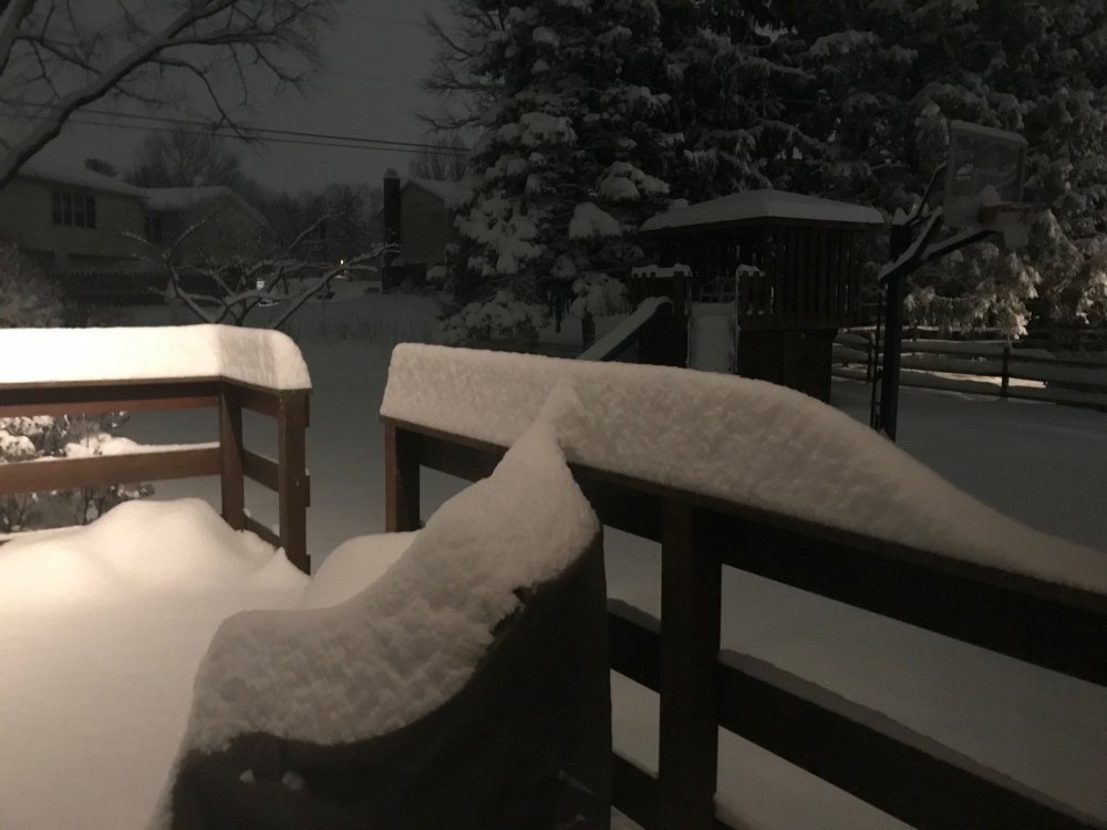
Ended up with 9.5"
NAM seems to be really struggling with the next system compared to the globals...12z GFS just underway.
Greed has taken over! Dare we stack up back to back 3+"--- perhaps a lottery ticket in store if we were to have such luck.
-
3
-
-
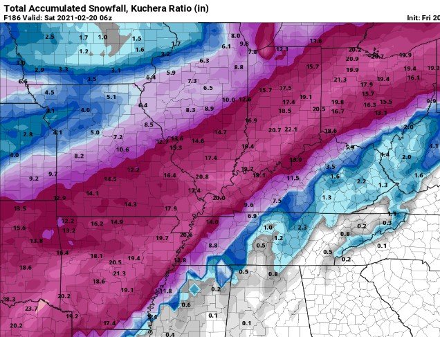
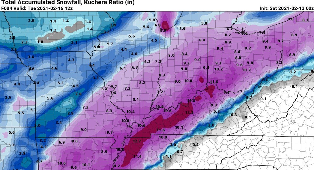
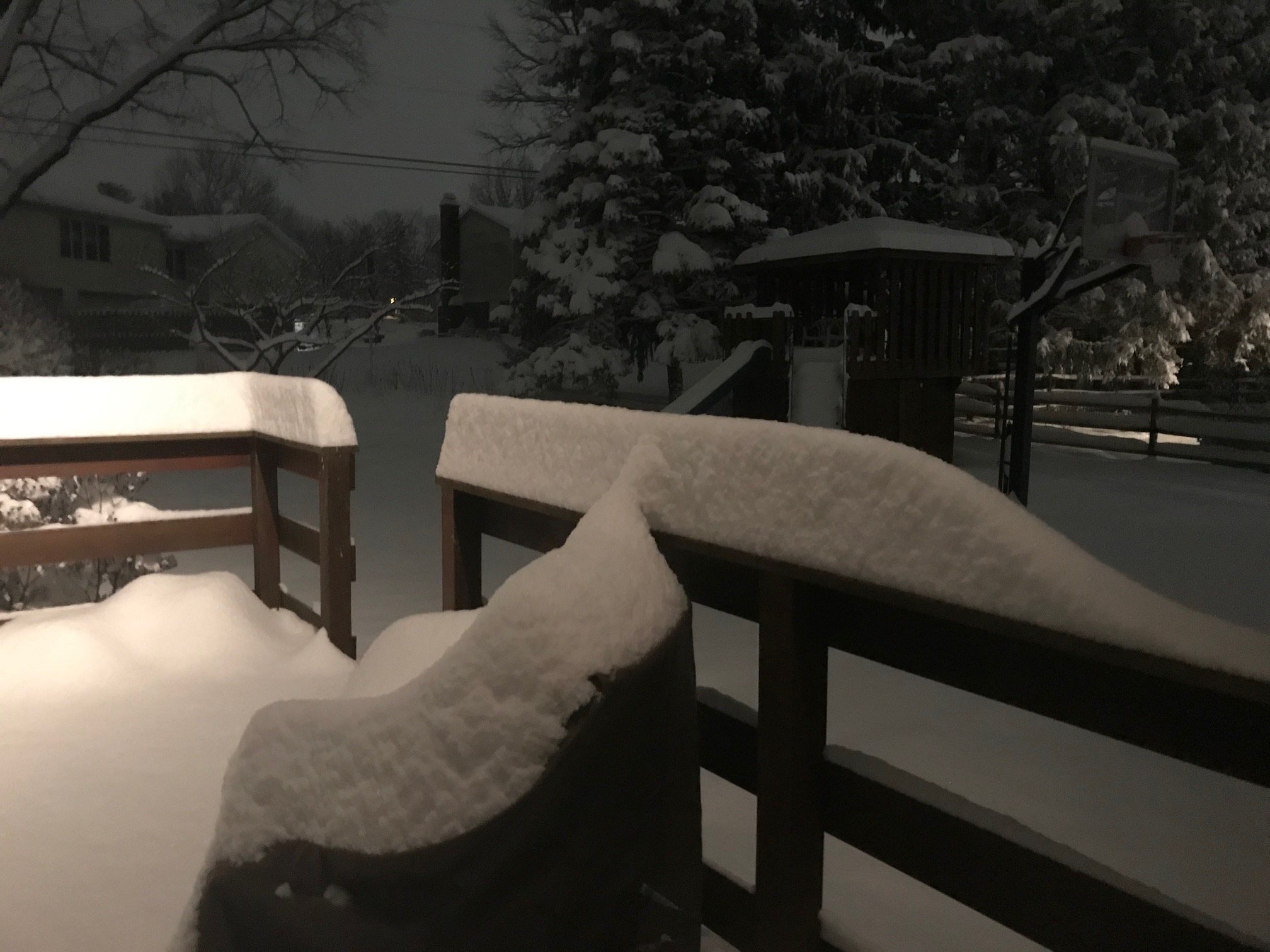
The lack of wind with this system has made for a spectacular scene. Easily have 7" here on the SE side of Cincy.
Year upon year of misses to the NW....finally nice to see an OVER Performer!
-
4
-
Let’s talk weather!
in Lakes/Ohio Valley
Posted
Slowing down the precip shield would be awesome..... GFS has been on the higher side all along...not sure why, I haven't dug into the QPF differences given our history of swing and miss....really have like the trends over the last 2.5 days..... Down here (SE Cincy) 9-1AM hour should be a sight to see....hoping to get into those snow squall warnings with howling wind!!! What do you think... 3" minimum for the constant snow globe for the next 2-3 days? 2" seems like it might break apart and leave a lot of bare spots with the wind.....
I am calling 4-6.....I bet we see a 5-8 stripe from Lawrenceburg NNE through Oxford and Greenville / Versailles (CoachLB!!!)
Holiday Greetings