

Chicago WX
-
Posts
18,285 -
Joined
Content Type
Profiles
Blogs
Forums
American Weather
Media Demo
Store
Gallery
Posts posted by Chicago WX
-
-
4 hours ago, vortex said:
Yeah, idk. Prolly a bit high Bourbonnais COOP is usually pretty conservative
Kankakee County...
Bourbonnais 7.5 in 0700 AM 01/13 COOPKankakee 1.4 WSW 5.8 in 0600 AM 01/13 COCORAHS
St. Anne 4.5 in 0700 AM 01/13 COOP
3 hours ago, King James said:I guess it makes sense: Could have been close to 6 with the early morning stuff and then a couple over night
The 5.8" is my report. Combination of the morning and overnight snowfall. 7.5" in Bourbonnais seems a bit high, but like vortex said, they're usually conservative. Most snowfall observers around here haven't the slightest clue what they're doing.
Anyways, work was a beach today. Westside of IKK had 4-5 foot drifts. Some houses entirely surrounded by those drifts. Quite a challenge for me. And wicked conditions tonight with the snow, wind gusts close to 40 mph, and single digit temps. Arctic fun.
-
 2
2
-
-
24 minutes ago, KeenerWx said:
This morning was briefly exciting, but rain throughout the day has eliminated nearly all snowcover. Unless a miracle happens with passing snow showers overnight, we’ll go into the deep cold with a bare ground. Even so, it’s been fun tracking the storm and watching it evolve over the past several days. Congrats to those who cashed in!
On somewhat of a futility watch - if we don’t get appreciable accumulation in the next two weeks, will be slightly behind the disaster of ‘22-‘23 winter to-date. Nuts.
Woof. We made it out with snow cover, though nothing like what was around this morning. It's a gloppy mess that is about to become a glacier. When the rain hit, it became some of the worst working conditions I've had in quite awhile. In the end, the morning was fantastic...the afternoon was horrific.
-
28 minutes ago, King James said:
Nah we are going to keep over performing. You and ALEK had us at nothing but rain and look at us now
We doing it
We shall see. No matter, event already exceeded my expectations. Knew we’d get some front end action, but didn’t expect this much.

-
2
-
-
3.5" at my 6:00 measurement. Still ripping with good flake size. Only about an hour to go. Temp up to 32º. Latest HRRR and RAP says we're pretty much done after this band swings through, with temps getting into the 40's and then rain for the rest of the event. Hopefully we don't lose all the snow cover, but it's gonna be dicey. Alas, I'm pleased with this mornings snowfall...didn't expect it honestly.
-
3
-
-
Ripping. Went out and measured 2.0" on my board. Temp at 30º. Great start to this one.
")
-
4
-
-
Good old NAM. Here I was about to give it credit after seeing the 18z Euro, and then it does this...
-
2 minutes ago, Radtechwxman said:
0z hrrr is very odd. Have a double barrel strengthening low. Both low centers strengthening. One tracks basically over me and the other well se. It changes over precip from east to west. Gets me in a waa screw hole between lows. Not sure I buy that evolution. Very strange.
All of the models have this feature. Look at the animations a couple of posts above. 18z Euro is a little different, in that it has the western low going farther north, like the NAM has been showing. Regardless, kinda interesting how they all have a changeover moving from east to west, to varying degrees. 18z HRRR was kinda the first show this. And then the trough feature that Joe pointed out.
I've been out of the main show for a couple of days, but it'll be interesting to watch this all unfold.
-
6 hours ago, A-L-E-K said:
Turn it up
-
 1
1
-
-
19 minutes ago, King James said:
GFS about to break my heart. Recent history suggest I’ll be in the rain with you
That's life riding the southern edge of winter storms. Need the buffer zone down by CMI 12-24 hours out, instead of over our heads. Lack of good cold didn't help either. Writing was on the wall a couple of days ago.
Better luck next winter.
-
Toss the RGEM. It was awful with the last storm. Suffers from the same cold/snow bias in marginal systems as other models.
I knew it was gonna get cold after this storm, but looked at my p&c and it has 0 for a high on Tuesday. That's gonna suck with no snow on the ground. At least the standing water in the yards will be skate-able.
-
 1
1
-
-
18z NAM is 0.0" for IKK surrounded on all sides by some accumulation. Perfect.
Though honestly, best part is it and the 3k limit the heavy rain to like 0.50-0.75". Can't take much more rainfall around here. River is high. Yards still with standing water from the last deluge.
EDIT: Eh, NAM dumps close to an inch of rain in the end.

-
1
-
-
-
12z Ukie is pretty far east. Jackpots northern Indiana and SW lower MI. FWIW of course…
12z Canadian models went north/west in their runs.
-
7 minutes ago, KeenerWx said:
Sounds like consensus is to throw out all the models.

That’s typical though, right?
But nah, my contention is throwing away the snowfall output, particularly for this area. GFS always too “cold”. And when you’re on the very southern edge of depicted snow, well you know how that goes 99% of the time. It’s gonna be a cold heavy rain here with a few flakes at the tail end.
Farther north and west, looks good. My thinking for most of NE IL north of I-80 has been 6-10”. Hopefully it overachieves for them.
-
1
-
-
12z GFS snowiest run yet for MBY. But most definitely, tossing the snow output as far as I can. We will be lucky to see a consolation inch at the very end. Looks good though for I-80 on north.
-
Wouldn't trust the HRRR or RAP at this range if my life depended on it.
Euro and GFS have been very consistent. Take them to the bank. Only thing you're seeing as we get closer in time is a refinement of the details. And a much more realistic outcome, i.e. them shaving the marginal edges with snowfall amounts. You're going to need residence time in the defo snows to get anything good. On the outskirts of that, enjoy white rain. Final call for here is 1.0-1.5". Of rain.
-
6 minutes ago, KeenerWx said:
It’s been trending more favorable, if ever so slightly. On the flip side, betting on a marginal set-up is risky. I think you’ll exit with a solid cover at worst (~3”), but have above 50/50 shot of warning level.
Hate being on the fringes. Knew I wasn't going to be in the main snow swath couple of days ago, but just hoping for some scraps at the tail end. Like, cover the grass tips. I have serious doubts that'll happen, based on prior experience with these marginal pieces of crap. But, one can always hope.
-
1
-
-
12 minutes ago, Harry said:
Good seeing you! Hope all has been well!
Time for me to raise the shields to keep this thing se of Ft. Wayne and Jackson! Time for that crap nw of there to end! Keep the mixed/rain crap east of here!
You too Harry. All good here.
And yeah, need to keep this east. 0z Ukie has a great track, good thermals, but is a bit stingy with the snowfall considering the former ingredients.
-
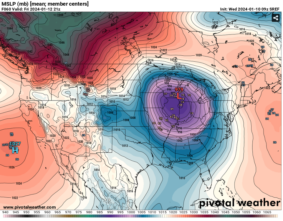
No two storms the same, but the short range meso models (ARW, NSSL, etc) were way too far northwest with the last system at this stage.
Current 0z runs of both, for this upcoming storm, have the slp in and near LAF at 48 hours (971mb ARW, 974mb NSSL).
Probably meaningless, alas...I'm grasping at straws. Just want a little snow cover before the arctic hounds visit.
-
3
-
-
3 minutes ago, Natester said:
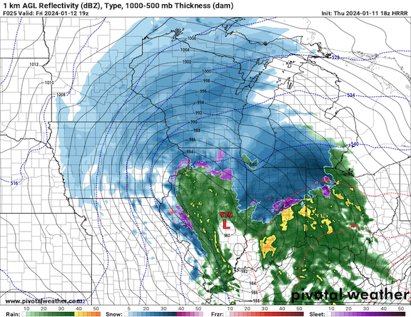
03z RAP takes the low to Chicago/Milwaukee and bombs it out to 965 mb.
Puff, puff, pass
-
1
-
-
19 minutes ago, King James said:
We are the kings of cold steady rain. Never should have moved south of 80
There’s a reason snowfall averages increase the further north you go. Alas, northwest suburbs were crying in the 20-21 and 21-22 winters while we were getting hit good. Sh*t happens…
-
1
-
-
28 minutes ago, A-L-E-K said:

Troll game still on point. Nice to see.
Euro did pretty good with the last storm, 3-4 days out compared to the other guidance. Only problem it has, along with other models, is it’s too generous around the southern/eastern edges of the wintry part of the storm, especially in very marginal air masses. I think I-80 and north in LOT’s CWA stands a good chance at 6-10”. And then obviously up through WI and then MI. IA good for a decent hit of WAA snows. For MBY, it’s a 99% rainer with a few token flakes at the end. Thankfully, this is the final big rainstorm for awhile. I’ll show myself back out the door now…
-
4
-
1
-
-
3 minutes ago, King James said:
Think we’ll get in on round 2?
Sure seems likely.
-
Little closer look. Nothing too exciting I guess, but thought I'd post.

-
2
-


January 13-17 (and beyond?) Cold Wave
in Lakes/Ohio Valley
Posted
My dogs love it. -3 right now. Winds ripping. Snowing. And they’re laying in the backyard in the snow. Have to beg them to come in.