

HighStakes
-
Posts
4,111 -
Joined
-
Last visited
Content Type
Profiles
Blogs
Forums
American Weather
Media Demo
Store
Gallery
Posts posted by HighStakes
-
-
Very light snow has begun.
-
12/11: 3.0
1/6: .8
1/14: .5
Total: 4.3
-
8 minutes ago, DDweatherman said:
Can’t help but think a compromise of the euro and the gfs gives the NW crew 4-5”
 and our DC brethren win too
GFS is really cold for northern crew. Temps never get above mid 20's fwiw.
-
 2
2
-
-
Heavy snow now. Relatively calm winds.
-
3
-
-
Moderate snow.
-
3
-
-
Just now, WxUSAF said:
Euro is 1-2” for metro areas. @CAPEbullseye with 2-3”. It’s actually close to bringing the coastal idea back and does for areas to our north.
At least every model gives us snow. Feeling confident that a complete miss is off the table ( famous last words lol. ) There's still time for minor improvements which would lead to a decent event to kick off the week.
-
3
-
-
4 minutes ago, BlizzardNole said:
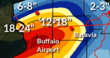
WOW I just looked at the Buffalo forecast and tomorrow's 1 pm game is going to be insane. I didn't know the stadium was south of the city which is in the better lake effect area. P&C has heavy snow with gusts to 45 during the day tomorrow with 16-28 inches total between tonight thru tomorrow night. Will they even play the game there?
Postponed til Monday at 4:30
-
1
-
-
Howling Winds here in the valley.
-
6 minutes ago, MillvilleWx said:
Well, looks like a light event or nothing which has been my fear overall. Was never into the amped idea. No storm or scraper. Ensembles trending SE was a hairbringer. NBM I imagine will follow suit, but 1-2” is very possible. Better coverage for NW of the fall line where temps should stay below 32° on Tuesday.
Agree! Still think there's a much better shot and a light event than a complete miss. I posted last night my gut was a light to moderate event. There's still plenty time to get this to improve back to a moderate event but anything amped is fading fast. Nonetheless still looking forward to next which should be our first real wintry week in 2 years.
-
3
-
-
Quite cold behind the Friday system. The Ravens will finally play a home playoff game in freezing weather. If Buffalo beats Pittsburg which is likely then that game will be ridiculous.
-
Every model now spreads snow over the area. The heaviest stripe has a consistent and similar location on all models just to different degrees on amounts.
-
2
-
-
Nothing wrong with a light to moderate event Tuesday especially with the late week storm looking better.
-
1
-
-
6 minutes ago, stormtracker said:
Oh well...next
We prefer you say FOLKS...
-
5
-
 4
4
-
-
1 minute ago, Heisy said:
I’m honestly shocked the euro did this again tonight after the other guidance. I don’t think I’ve ever seen this honestly
.Me too. I thought for sure it would come back at 0Z.
-
8 minutes ago, Deck Pic said:
That was december 2001. We were at WWBB or maybe weather.com. JB kept promising us vodka cold and I hit 81 on January 30th 2002
7 minutes ago, Ji said:I still remember when Keith Allen said pd 2003 was going to be rain. Ignored your Pittsburgh rule
Sent from my SM-A515U using Tapatalk
I remember reading Gary Gray and his long posts breaking down each model run before PD2. I had just turned 30. 20 years in the blink of an eye!
-
3
-
-
7 minutes ago, Terpeast said:
I looked again, and this new gfs run does seem slower and develops the storm later
Like you said until the cutter is out the way there will be more ebbs and flows. Having the cold available with the arctic boundary really helps us. I just can't see this missing us completely. Gut feelings says moderate storm. Fingers crossed.
-
2
-
-
One thing that I really like seeing is the precipation firmeld is very broad. Lighter snows spread well north and west of the LP center. As of now those of us further north are not fighting a sharp cutoff if the more SE solutions comes to fruition. Not going to take a lot of liquid to produce several inches.
-
1
-
-
5 minutes ago, Terpeast said:
For me, when the gfs and euro trend the same way, it’s a sign. But tomorrow’s cutter still hasn’t grown to full strength and cleared the CONUS yet. That will determine the strength and location of the TPV, and it is still TBD. While I had a moment of frustration with the trends, I get that we should expect a lot of wavering for a couple more days. Especially with this new trailing wave idea that the euro (and gfs?) seems to be picking up on.
And this gfs run while further SE, if that s/w just digs a little more and tilts, we still retain the upside potential.
We’re not out of this yet, but the goal posts are such that we can still whiff.
I disagree about the GFS and Euro trending the same way. This solution by the GFS was totally opposite of the Euro. Tonight's GFS keyed on another feature and was 12 hours slower than its own 18z run. Euro was simply squashed. I actually feel really good on everyone' chances. Just way too early to be overly concerned.
-
2
-
-
I really like this set up. There's a lot to like about this potential if you're expectations are realistic. A moderate snowstorm with a SECS upside is very much alive.
-
12
-
-
@psuhoffmanThe 1/22/87 was one of my favorites. I think you're few years younger than me so I'm not sure how much you remember about the storm and the forecast leading up to it. My best recollection was that it was poorly forecasted. I believe there was a lot of uncertainty right up to game time. Most calls for the Baltimore area was for 2-4 with some 3-6 with a change to rain. Pretty sure schools started out with a 2 hour delay then changed to closed. By mid-morning light snow transitioned into heavy snow. By noon temperatures began falling making it evident there would be no changeover. Snow remained heavy hour after hour. Rates were at least 2 inches an hour at times. There was thunder snow during the afternoon. NWS played catch up all day. 3-6 became 4-8 then 6-12 and finally 12-18. Snow tapered off by evening with totals where I lived 1 mile north of the beltway in Pikesville/Owings Mills in the 16-18 range. BWI was officially 12. Phenomenal storm which for me had scaled down similarities to the 83 storm. 83 was colder and of course had much higher totals but 87 was similar in duration and sustained snowfall intensity rates. Also heck of an arctic shot behind the storm which led to perhaps one of the driest snows I've ever experienced just 3 days later on Superbowl Sunday. That follow-up storm gave me about 6 of cold smoke powder. Our current area was probably fringed a bit lol. with 4 or so. Just to the south and southeast got much heavier amounts. Great little stretch of intense winter that would essentially be it for the winter other than the Feb. 87 wet snow paste job.
-
7
-
 1
1
-
-
2 minutes ago, WxUSAF said:
Yeah, I actually liked the gfs op run verbatim quite a bit. Chances keep coming the whole 16 days.
Our first real chance since Feb. 2015 at sustained "deep winter" if everything comes together with the caveat of it occurring in the heart of winter and extending into our best climo period.
-
4
-
-
7 minutes ago, Deck Pic said:
I believe that was much colder - after the reinforcing shot following storm 1 - but maybe similar?
Here's 96 - super similar....our trough is a little more positively tilted
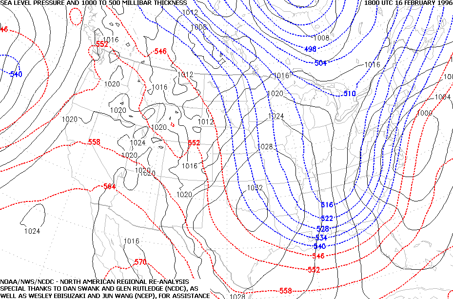
How about the early Feb. 96 storm. Maybe some similarities with that one also. Regardless I'm just happy to see legit cold across the region.
-
3 minutes ago, Deck Pic said:
Kuchera vs 10:1
We could def get 12:1 overall...with some 15:1....if the storm even happens or exists
This reminds me of one of the Feb 96 storms....I think the 2nd.....2/16/96
Also reminds me of a scaled down version of 1/25-26/87. That was a cold storm as well.
-
1
-
-
Nice to finally see that cold will not be the problem if the event materializes.
Jan 15-16 Storm Thread 3: Obs and Disco
in Mid Atlantic
Posted
GFS has northern MD in the single digits Wednesday morning and barely gets out of the teens for highs.