outflow
-
Posts
290 -
Joined
-
Last visited
Content Type
Profiles
Blogs
Forums
American Weather
Media Demo
Store
Gallery
Everything posted by outflow
-
2022 Short/Medium Range Severe Weather Discussion
outflow replied to Chicago Storm's topic in Lakes/Ohio Valley
Now that the lakes are near or at there warmest I wouldn't mind some unseasonably cool temps for maybe a couple waterspout days. -
We get the Ohio version instead. "Referring to Spartan in case someone didn't get the reference"
-
Winds will die quickly as soon as daytime mixing stops
-
2022 Short/Medium Range Severe Weather Discussion
outflow replied to Chicago Storm's topic in Lakes/Ohio Valley
Updated to 44 injuries -
2022 Short/Medium Range Severe Weather Discussion
outflow replied to Chicago Storm's topic in Lakes/Ohio Valley
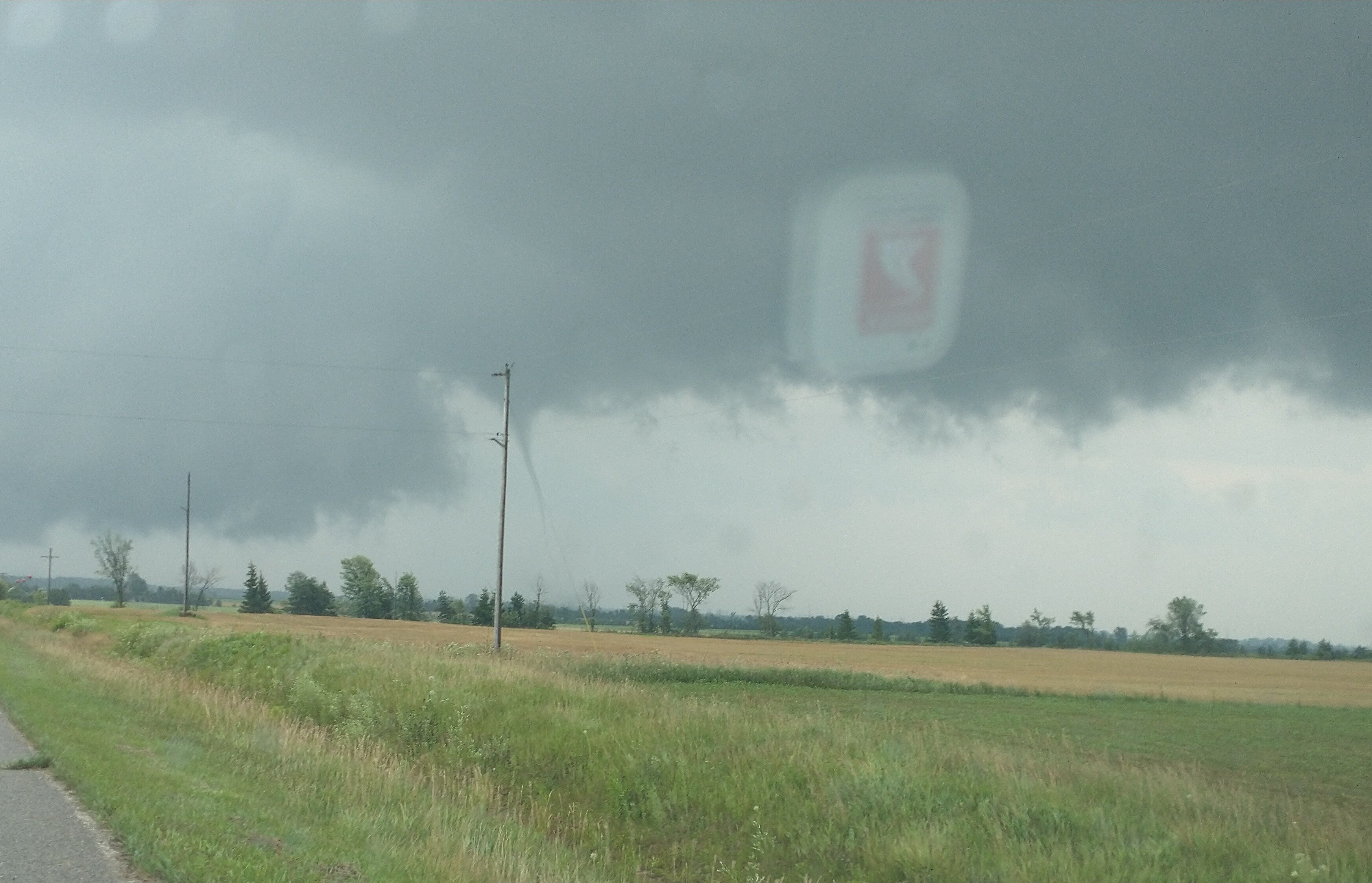
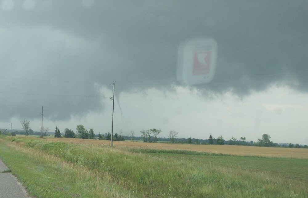
If it is rated an ef3, damage looks like ef2-3 will be the rating, it would be the first ef or f3 or higher tornado in the Gaylord forecast area 31 years and first in the entire state of Michigan in 10 years -
2022 Short/Medium Range Severe Weather Discussion
outflow replied to Chicago Storm's topic in Lakes/Ohio Valley
One dead and 23 with injuries. 1st death from a tornado in Michigan in 12 years https://www.wnem.com/2022/05/21/least-1-dead-23-hurt-northern-michigan-tornado/ -
2022 Short/Medium Range Severe Weather Discussion
outflow replied to Chicago Storm's topic in Lakes/Ohio Valley
Gaylord is more heavily residential east and se of i75 so it missed the most densely populated area of town to the northwest -
2022 Short/Medium Range Severe Weather Discussion
outflow replied to Chicago Storm's topic in Lakes/Ohio Valley
Multiple injuries some trapped per scanner -
2022 Short/Medium Range Severe Weather Discussion
outflow replied to Chicago Storm's topic in Lakes/Ohio Valley
This is/was a big tornado cc drop is large not good -
2022 Short/Medium Range Severe Weather Discussion
outflow replied to Chicago Storm's topic in Lakes/Ohio Valley
Hope that the elevated stuff in Wisconsin can survive the night and lay an outflow boundary somewhere toward the us10 area that something could fire and latch on too. Once you get north as others have said it's all hills/trees and a very spotty road network. Chances it happens are not high but it's better then trying to work up north. Or wait for a better day. -
RIP harbor springs mi Heavy Snow and Windy 25°F -4°C Humidity 96% Wind Speed SW 44 G 101 mph Barometer 29.43 in Dewpoint 24°F (-4°C) Visibility 0.50 mi Wind Chill 5°F (-15°C) Last update 18 Feb 9:55 pm EST
-
There is a set of trails that run in eastern sanilac county/se Huron county over here in the thumb, I don't ride so no idea what they are like but I see the maps every once/while hanging in a couple local sporting goods shops
-
I'm surprised you have any healthy ash trees left down there. The emerald ash borer wiped out almost all of them in Michigan in the past 10 years.
-
Did you notice the second tornado/waterspout that occurred to the nw of the main tornado? Around the time the above tornado was roping out, I looked to the north from m25 and could see a second funnel and thin condesation funnel about 3 miles nnw. The funnel went behind the treeline so I couldn't get a good look to see if/where it was on the ground at. I found a video online that appears to show the second tornado/spout I seen. https://m.facebook.com/groups/147834125298027/permalink/4161742787240454/?anchor_composer=false
-
https://www.facebook.com/564090982/videos/260458999220451/ link to video from todays port austin tornado. not the greatest thing in the world recording with my phone but for a michigan tornado not hidden in rain/grunge ill take it.
-
Btw this touched down less then a mile from where last months ef2 hit. As it roped out
-
It was on the ground for about 5 miles missed pretty much any structures minus one barn it destroyed. I have more pictures and video just need to figure out how to post the video since I hate technology
-
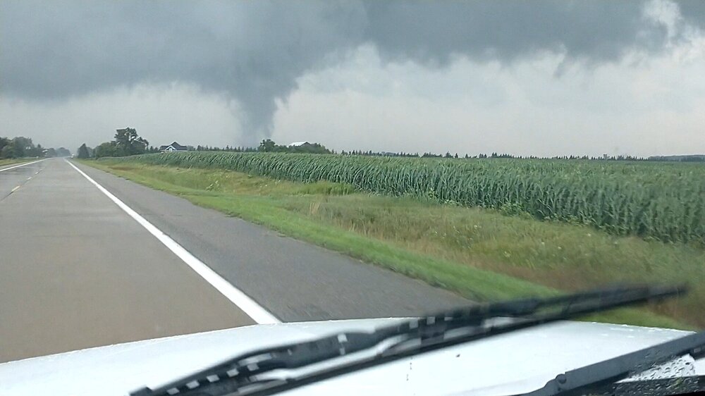
Port Austin mi tornado ef2 with 120 mph winds
-
6 non life threatening injuries. Damage pictures look like high end ef1 type damage. https://m.facebook.com/story/graphql_permalink/?graphql_id=UzpfSTgzMDQwMjkyNTU4OjEwMTU5MTU5MDM4MzQ3NTU5 We got Very lucky up here. There wasn't a warning for this and based on a similar storm I was following about 8 miles west right before this touched down there was little or no lightning. There was a festival going on in downtown port Austin proper called porchfest where a bunch of bands play music on the larger open porch/front yards of homes in town and people walk place to place. Another 3/4 of a mile north would have taken it through the center of town with lots of people in the open and no real idea of how bad it would get. It could have been a pretty bad situation. Btw anyone have the radar loop from around 5-6pm for around the upper thumb of mi? I have radarscope but don't have the yearly subscription for archived products. The storm I was on moved onshore south of caseville with a ground scraping lowering and a decent radar dig but moved offshore without producing. Im curious what the storm by port Austin looked like since I didn't see anything of note before looking away from my phone to drive home.
-
Port Austin mi 15 miles north of me got bit by an unwarned tornado earlier. Reports of some possible injuries. I'll have to go tomorrow to see if I can get any pictures
-
-1.15
-
You would think with that type of swing something interesting would have had to have occurred in that two week span but zzzzzzz
-
Central Nebraska, north Platte?, At 285 days is unbelievable, they are only 5 days ahead of Marquette.
-
https://www.kbtx.com/2021/04/19/new-strain-of-covid-19-identified-by-texas-am-researchers/
-
A local hospital in Sandusky mi who doesn't have an icu had to transfer covid patients to Toledo Ohio for care as the nearest place able to take them. Sandusky is about 90 miles north of Detroit so and about 60-70 miles from Saginaw/Flint so from them to have to go to Toledo to find open bed shows how bad the situation is up here right now https://www.wnem.com/news/increase-in-covid-19-cases-making-it-hard-for-thumb-region-hospitals-to-provide-adequate/article_400aa316-9e2a-11eb-a5d1-83e481510428.html?fbclid=IwAR1uj9tKxyecXoU7pcxVF7B5t3Cr_MwbyBc48WBNnuleT8Ly1Yl59S_Kvfo