

Hvward
-
Posts
3,417 -
Joined
-
Last visited
Content Type
Profiles
Blogs
Forums
American Weather
Media Demo
Store
Gallery
Posts posted by Hvward
-
-
Looks like we have around 3” in Alexander, not going out there right now to measure ha. One of the best northwest flows I can remember.
-
 7
7
-
-
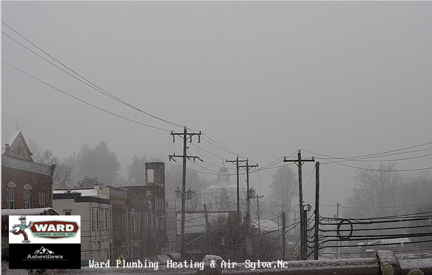
Getting hammered here in Alexander, already around a half inch or so in broad daylight. These are the northwest flows we missed, I forgot what it was like to just have a mega swath of moisture give all of Buncombe snowfall for a few hours. Roads are starting to get covered as WNC said.
-
10
-
-
Got some nice NWF coming down here right now in Alexander. We have already picked up a dusting. Great rates.
-
4
-
-
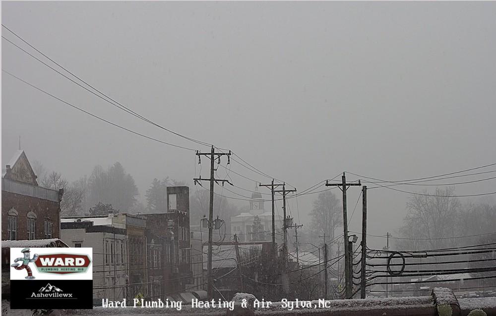
Sylva getting plastered on the live cam.
https://www.ashevillewx.com/ward-plumbing-hvac-sylva-nc-cam
-
7
-
-
Hoping you're right, Hvward. But, it's funny just how different things can be across parts of Asheville. I'm at 2110' and 41.6 degrees.
Yeah I am in the northern part of Buncombe, we seem to be getting a bit of that arctic air to filter in down the French Broad.-
3
-
-
Feels like we were down big but are pulling a miracle second half comeback. I am down to 35.8, models had me at 42 right now and there is still a good bit of precip to pull through the area.
-
8
-
-
Flurries showing up on one of my Maggie Valley cams.
-
8
-
-
18z Nam 3km expanded the southern periphery of moisture. Has many around WNC getting snow showers around 8-9pm tonight. Models are clearly struggling with what the moisture is going to do when it hits the mountains.
-
4
-
-
Thanks everyone I’ll be live at 6pm.
-
3
-
-
Are you doing a video/map today?
Sent from my SM-S908U using Tapatalk
Yeah sometime this evening. Trying to get my thoughts together and see what the radar shows. Sometimes I wish I could just enjoy it and just watch the window haha.-
6
-
-
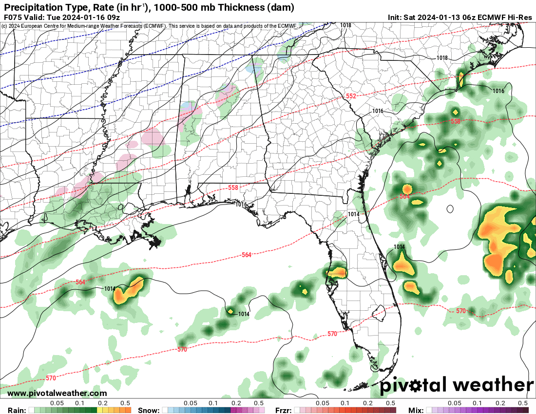
Lots of moisture in Northern Mississippi developing right now. HRRR doesn’t show anything over Tupelo for another 4 hours but mping is showing frozen precip.
-
9
-
-
One thing I am noticing on the 6z Euro is the idea of the stream staying intact for a longer duration. Check out the banding that is showing Tuesday morning now across parts of AL, MS, & GA. Looking back at the past several Euro runs this is by far the most moisture being shown across those areas in that time frame. Also shows it as frozen. That SW directional flow would still support the fire hose into WNC.
-
2
-
 1
1
-
-
We could see a very high end Northwest Flow event on Friday and into Saturday if we have a low bomb out over the Great Lakes. With the ULL as well that looks awesome. This would be the type to bring Downtown Asheville an inch or two if it verifies.
Obviously this did not verify. Admittedly I think I was a bit over zealous. The low trended a bit more north, but I think we get better flow into Asheville when the low bombs out on the coast. Hoping to see some good backside flow with this next system late Tuesday.-
3
-
-
Trend is our friend this morning. 6z Euro looks great. I could see Asheville getting 3"-6" if trends continue.
-
12
-
-
23 minutes ago, Buckethead said:
I just went back and read the thread. The Nam/navgem led the way on that one. Gfs and euro had nothing for us 2 days before the event.
Sent from my SM-S908U using Tapatalk
Haha yep the Navgem, its one shining moment. I think I posted it several time. The southern periphery of the moisture was really under modeled in Dec 2017 and it ended up being much more than models showed. There was much less of a southern component though from my memory. Hopefully short range models begin to give us a better idea here soon.
-
1
-
1
-
-
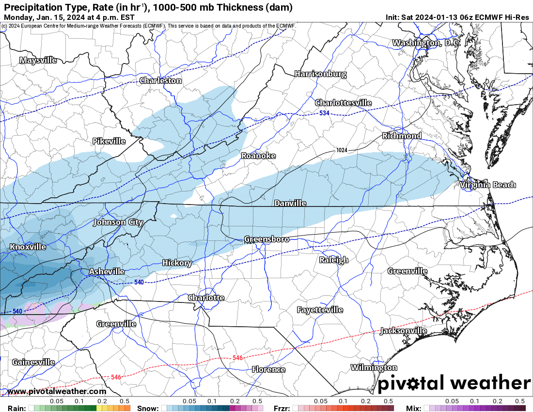
Has it ever happened where Gatlinburg got a foot of snow and Asheville got nothing? This one just isn't making sense to me. That initial baroclinic leaf just stops at the line? The skew T shows a pretty saturated column but the downsloping in the lower levels dries it out. The skew T still shows snow is the p type though. I have more questions than answers right now on this one.
-
9
-
-
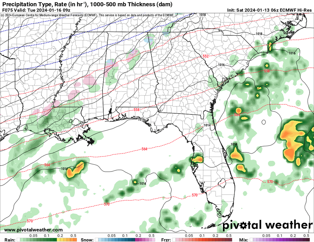
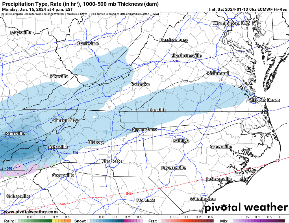
Models always struggle with overrunning precip here. I go back to the Dec 2017 storm where a stream of moisture setup similar to what the Euro shows now. We got 9". Honestly... looking at the skew T, moisture is in the snow growth zone per 12z Euro from early Monday through Tuesday around Asheville. Temp barely goes above freezing as well during that time period. You can clearly see the models struggling with this, but I am giving WNC pretty good odds right now to see snow accumulation of some kind Monday and into Tuesday.
-
7
-
-
We could see a very high end Northwest Flow event on Friday and into Saturday if we have a low bomb out over the Great Lakes. With the ULL as well that looks awesome. This would be the type to bring Downtown Asheville an inch or two if it verifies.
-
11
-
 1
1
-
-
The pattern setting up for Mon/Tues of next week has moisture and cold, two things we haven't been able to line up yet this season. I just looked back at the last 10 runs of the GFS and at this range, I would take any of those setups this far out. Magic can happen here in WNC with patterns like this. Euro also has a very nice look now, but looking back at the past several runs, it has been all over the place. Now it is showing something similar to the GFS. At this range, this is a pattern we should all like. Setups similar to this have worked out many times in the past for us. Looking forward to coming home from Puerto Rico and tracking this beast. Full disclosure I was really pulling for the last system to turn into a dud since I was going to be out of town lol.
-
21
-
1
-
-
Amped up and no strong high pressure to provide cold air has me concerned. Saturday could still happen but the trend is a stronger warm nose today. Euro Ensemble still looks good, but we have seen that miss as well before.
-
4
-
-
Just popping in to say this ULL is our first real chance of the season. Someone could get hammered very quickly.
-
8
-
-
Some snow showers possible this afternoon along the border and then it looks like some convective snow showers will be possible tomorrow afternoon around WNC. Above 3500' could pick up a couple of inches here. Winter isn't dead just yet. Temps look to drop into the teens for some Tuesday morning. Thats going to just about do in any buds around. Doesn't matter if they have frost protection or not.
-
6
-
-
Are we gonna get dopped again by the models? I feel like Charlie Brown..
-
1
-
 1
1
-
-
Nam starting to pick up on the deformation band. I still think snowfall accumulation is possible. Look at all of that moisture on the Gulf Coast that is projected to move through the area.
-
5
-
2023-2024 Fall/Winter Mountain Thread
in Southeastern States
Posted
This morning around Asheville it seems if you drive up the right hill you switch to snow.