

oconeexman
-
Posts
2,043 -
Joined
-
Last visited
Content Type
Profiles
Blogs
Forums
American Weather
Media Demo
Store
Gallery
Posts posted by oconeexman
-
-
9 minutes ago, burrel2 said:
I'll go ahead and cash out with the dusting the Hrrr and NAM are showing for the upstate. Can't complain if we get a nice little band to swing through and drop a coating across the upstate and NC foothills/piedmont
Yes I had resided to maybe some flurries and I'd be ok with that. Still have snow in parts of my yard even after the rain. But now I'm thinking a solid dusting up here is a real possibility. Nonetheless almost the whole state will see winter weather...thats pretty dam cool!
-
 4
4
-
-
Finally all snow!!
-
4
-
-
1 minute ago, lilj4425 said:
Ground starting to cover here near Mauldin. Coming down heavy. All snow.
Blue turd for the win! Congrats
-
1
-
 1
1
-
-
40 minutes ago, NEGa said:
The snow is really picking up here. The deck is starting to turn white.
Painful watching this rain/snow not being all snow! Temp finally dropping 35
-
7 minutes ago, NEGa said:
The snow is really picking up here. The deck is starting to turn white.
Told u this one is gonna be good for you! Congrats
-
1
-
-
Full on mix now..moderate
-
1
-
-
Light rain/snow mix
-
Light snow here..baby flakes
36/31
-
3
-
-
-
Just now, NEGa said:
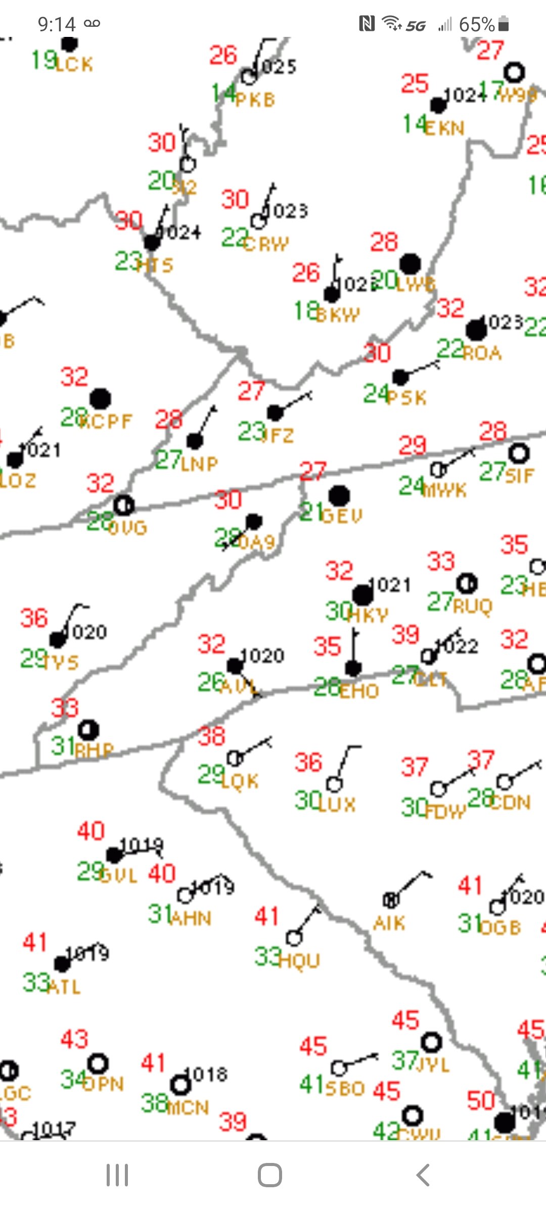
Current temp 36 with a dew point of 29. What I am really liking is the wedge is coming in and it’s obvious lol. There is quite a ne wind right now. Usually when a storm is a complete bust I don’t notice the wind before hand. This morning it is quite noticeable yay
My sentiment exactly. Up to 39 with thick cloud deck and stout ne breeze. Obvious cad rolling in at the perfect time.
-
1
-
-
Incoming wedge

-
2
-
-
5 minutes ago, Amos83 said:
best site to track dew points?
-
1
-
-
36/31 ene8-10mph
-
1
-
-
7 minutes ago, franklin NCwx said:
No 18z euro update?
-
7 minutes ago, burrel2 said:
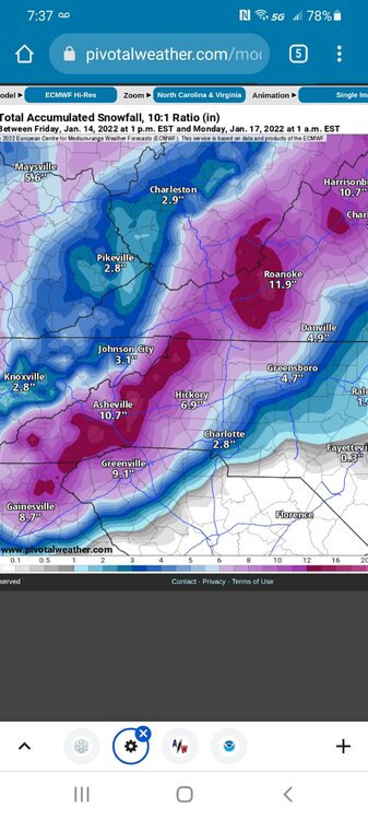
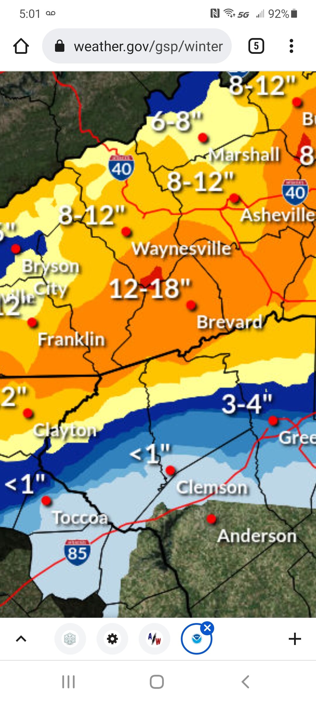
Literally no model has trended towards less snow in southern oconee/pickens county in the last 24 hours. All of them other than the GFS are showing accumulating snow with the frontal band. The hi-res models that have come in to range look great for this area... and NWS GSP cuts totals to 0? lmao
They did this last time I got 4+"..lol
-
3
-
 1
1
-
-
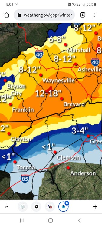
Gsp on que drops totals here after warning.
-
1
-
1
-
 1
1
-
-
Let's see what the 12z nam does here. I expect some minor changes.
-
10 minutes ago, buckeyefan1 said:


As the euro has steadily forecasted extreme upstate and extreme ne ga are in for a major here. Sw Nc will get pummeled for sure. Still time for adjustments and they will impact alot of folks good and bad. The latest trend is important imo of a south jog of the primary and track. Looking forward to today's changes!
-
5
-
-
Just now, burrel2 said:
Honestly, cmc is great for the western upstate. Front end 4-8 inch thump followed by sleet with temps around 25.
I thought that's what I saw. I'm all in so far...we may fail in the end but I'm still pumped for our area. I get the changeover is more likely to occur but if I can watch that much snow fall and accumulate I'd be perfectly fine.
-
Am I missing something? "Sleetfest even for the mountains"
-
2
-
1
-
-
5 minutes ago, LiQuiDBuD said:
Mass suicide in the main thread right now. Glad to be able to join all you mountain folks right here!
Sent from my Pixel 6 Pro using Tapatalk
Yep on both sites...obviously highly populated with central nc folks. Last storm I never had a shot so I sat on the sideline and cheered on and admired the video and pics.
For nw sc and ne ga which are mountainous so hopefully I'm allowed to post with you fellas, I firmly believe and have seen the gradient before where we stayed mostly snow with a transition to sleet turning back to snow. The temp profiles look great early on and possibly could lock in if some precip moves in earlier than modeled.
-
1
-
1
-
-
3 hours ago, burrel2 said:
I’m trying to remain happy here… all models showing 1-2 inch liquid for the upstate and worst case it will be a raging sleet storm with temps in the mid 20s. It’s been a long time since we've experienced that. I still think there’s a 50/50 chance we get significant snow accumulations on the front end as well. Can’t complain about that at this point!
At this point I'm starting to wonder about that finger of precip that's not showing up yet and could that be all snow and help nw sc and ne ga out a bit? Possibly help us stay snow a little longer before the changeover.
-
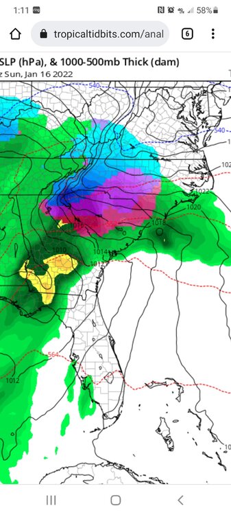
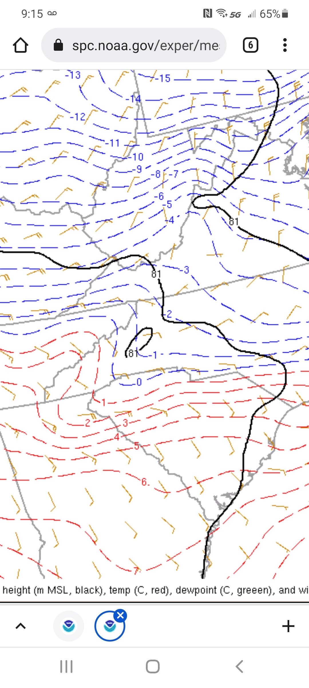
We are in desperate need of some blocking and CAD..or at least me and Ne Ga folks!
-
2
-
-


Mid to Long Range Discussion ~ 2022
in Southeastern States
Posted
Icon coming in colder but still a little too warm. But we know the warm bias it has esp in a CAD situation. Gonna be some model watching fun over the next week at least
Sent from my SM-G986U using Tapatalk