

kayman
-
Posts
544 -
Joined
-
Last visited
Content Type
Profiles
Blogs
Forums
American Weather
Media Demo
Store
Gallery
Posts posted by kayman
-
-
Central Alabama supercell is still producing a TDS with debris ball on the CC from BMX radar
Severe Weather Statement
National Weather Service Birmingham AL
1111 PM CDT Tue Apr 2 2024
ALC021-030430-
/O.CON.KBMX.TO.W.0003.000000T0000Z-240403T0430Z/
Chilton AL-
1111 PM CDT Tue Apr 2 2024
...A TORNADO WARNING REMAINS IN EFFECT UNTIL 1130 PM CDT FOR EAST
CENTRAL CHILTON COUNTY...
At 1111 PM CDT, a confirmed tornado was located near Higgins Ferry
Park, or 10 miles east of Clanton, moving east at 50 mph.
HAZARD...Damaging tornado.
SOURCE...Radar confirmed tornado.
IMPACT...Flying debris will be dangerous to those caught without
shelter. Mobile homes will be damaged or destroyed. Damage
to roofs, windows, and vehicles will occur. Tree damage is
likely.
Locations impacted include...
Higgins Ferry Park, Mitchell Lake, and Mitchell Dam.
PRECAUTIONARY/PREPAREDNESS ACTIONS...
To repeat, a tornado is on the ground. TAKE COVER NOW! Move to a
basement or an interior room on the lowest floor of a sturdy
building. Avoid windows. If you are outdoors, in a mobile home, or in
a vehicle, move to the closest substantial shelter and protect
yourself from flying debris.
&&
LAT...LON 3275 8649 3284 8654 3287 8646 3286 8645
3283 8646 3282 8646 3280 8644 3279 8641
3277 8641 3276 8639
TIME...MOT...LOC 0411Z 252DEG 43KT 3281 8645
TORNADO...OBSERVED
MAX HAIL SIZE...<.75 IN
$$
40/Sizemore
-
The prior TDS supercell that went through Conyers in Rockdale County appears to be cycling at the moment but it's still has a strong low-level circulation. Those in southern Walton County towards Monroe needs to be watching this closely.
-
Also the storm hitting the South side of Greater Birmingham is also intensifying as well! It's set to cross I-65 in moments with a strong TDS as well!
-
1 minute ago, SluggerWx said:
Huge debris signature in that Conyers cell.
Sent from my Pixel 6 using Tapatalk
Yes it is hitting the downtown area of Conyers right now!
-
Confirmed TDS with the same supercell on the Southside of the Greater Birmingham area again
Tornado Warning
Severe Weather Statement
National Weather Service Birmingham AL
1052 PM CDT Tue Apr 2 2024
ALC001-021-030430-
/O.CON.KBMX.TO.W.0003.000000T0000Z-240403T0430Z/
Autauga AL-Chilton AL-
1052 PM CDT Tue Apr 2 2024
...A TORNADO WARNING REMAINS IN EFFECT UNTIL 1130 PM CDT FOR
NORTHEASTERN AUTAUGA AND SOUTHEASTERN CHILTON COUNTIES...
At 1052 PM CDT, a confirmed tornado was located over Pooles
Crossroads, or 8 miles southwest of Clanton, moving east at 50 mph.
HAZARD...Damaging tornado.
SOURCE...Radar confirmed tornado.
IMPACT...Flying debris will be dangerous to those caught without
shelter. Mobile homes will be damaged or destroyed. Damage
to roofs, windows, and vehicles will occur. Tree damage is
likely.
Locations impacted include...
Clanton, Marbury, Higgins Ferry Park, Verbena, Pooles Crossroads,
Mitchell Lake, Cooper, and Mitchell Dam.
PRECAUTIONARY/PREPAREDNESS ACTIONS...
To repeat, a tornado is on the ground. TAKE COVER NOW! Move to a
basement or an interior room on the lowest floor of a sturdy
building. Avoid windows. If you are outdoors, in a mobile home, or in
a vehicle, move to the closest substantial shelter and protect
yourself from flying debris.
&&
LAT...LON 3269 8675 3276 8677 3287 8646 3286 8645
3283 8646 3282 8646 3280 8644 3279 8641
3277 8641 3275 8638 3275 8641 3269 8641
TIME...MOT...LOC 0352Z 252DEG 44KT 3273 8671
TORNADO...OBSERVED
MAX HAIL SIZE...<.75 IN
$$
40/Sizemore
-
Confirmed TDS over Rockdale County in the eastern suburbs of Metro Atlanta headed directly for Conyers
Severe Weather Statement
Severe Weather Statement
National Weather Service Peachtree City GA
1155 PM EDT Tue Apr 2 2024
GAC247-030430-
/O.CON.KFFC.TO.W.0002.000000T0000Z-240403T0430Z/
Rockdale GA-
1155 PM EDT Tue Apr 2 2024
...A TORNADO WARNING REMAINS IN EFFECT UNTIL 1230 AM EDT FOR
NORTHEASTERN ROCKDALE COUNTY...
At 1154 PM EDT, a confirmed tornado was located over Lakeview
Estates, or over Conyers, moving northeast at 35 mph.
HAZARD...Damaging tornado.
SOURCE...Radar confirmed tornado.
IMPACT...Flying debris will be dangerous to those caught without
shelter. Mobile homes will be damaged or destroyed. Damage
to roofs, windows, and vehicles will occur. Tree damage is
likely.
Locations impacted include...
Conyers, Lakeview Estates, Georgia International Horse Park, and
Milstead.
PRECAUTIONARY/PREPAREDNESS ACTIONS...
To repeat, a tornado is on the ground. TAKE COVER NOW! Move to a
basement or an interior room on the lowest floor of a sturdy
building. Avoid windows. If you are outdoors, in a mobile home, or in
a vehicle, move to the closest substantial shelter and protect
yourself from flying debris.
&&
LAT...LON 3364 8406 3368 8409 3371 8407 3376 8402
3373 8394 3367 8393
TIME...MOT...LOC 0354Z 245DEG 29KT 3368 8404
TORNADO...OBSERVED
MAX HAIL SIZE...<.75 IN
$$
-
Severe Weather Statement
National Weather Service Birmingham AL
1032 PM CDT Tue Apr 2 2024
ALC021-047-030400-
/O.CON.KBMX.TO.W.0002.000000T0000Z-240403T0400Z/
Chilton AL-Dallas AL-
1032 PM CDT Tue Apr 2 2024
...A TORNADO WARNING REMAINS IN EFFECT UNTIL 1100 PM CDT FOR
SOUTHWESTERN CHILTON AND NORTHEASTERN DALLAS COUNTIES...
At 1032 PM CDT, a confirmed tornado was located near Parnell, or 10
miles north of Valley Grande, moving east at 50 mph.
HAZARD...Damaging tornado.
SOURCE...Radar confirmed tornado.
IMPACT...Flying debris will be dangerous to those caught without
shelter. Mobile homes will be damaged or destroyed. Damage
to roofs, windows, and vehicles will occur. Tree damage is
likely.
Locations impacted include...
Plantersville.
PRECAUTIONARY/PREPAREDNESS ACTIONS...
To repeat, a tornado is on the ground. TAKE COVER NOW! Move to a
basement or an interior room on the lowest floor of a sturdy
building. Avoid windows. If you are outdoors, in a mobile home, or in
a vehicle, move to the closest substantial shelter and protect
yourself from flying debris.
&&
LAT...LON 3260 8704 3262 8705 3264 8705 3266 8703
3270 8703 3275 8693 3266 8691 3266 8692
3264 8692 3263 8691 3261 8691
TIME...MOT...LOC 0332Z 251DEG 44KT 3267 8698
TORNADO...OBSERVED
MAX HAIL SIZE...<.75 IN
$$
40/Sizemore
-
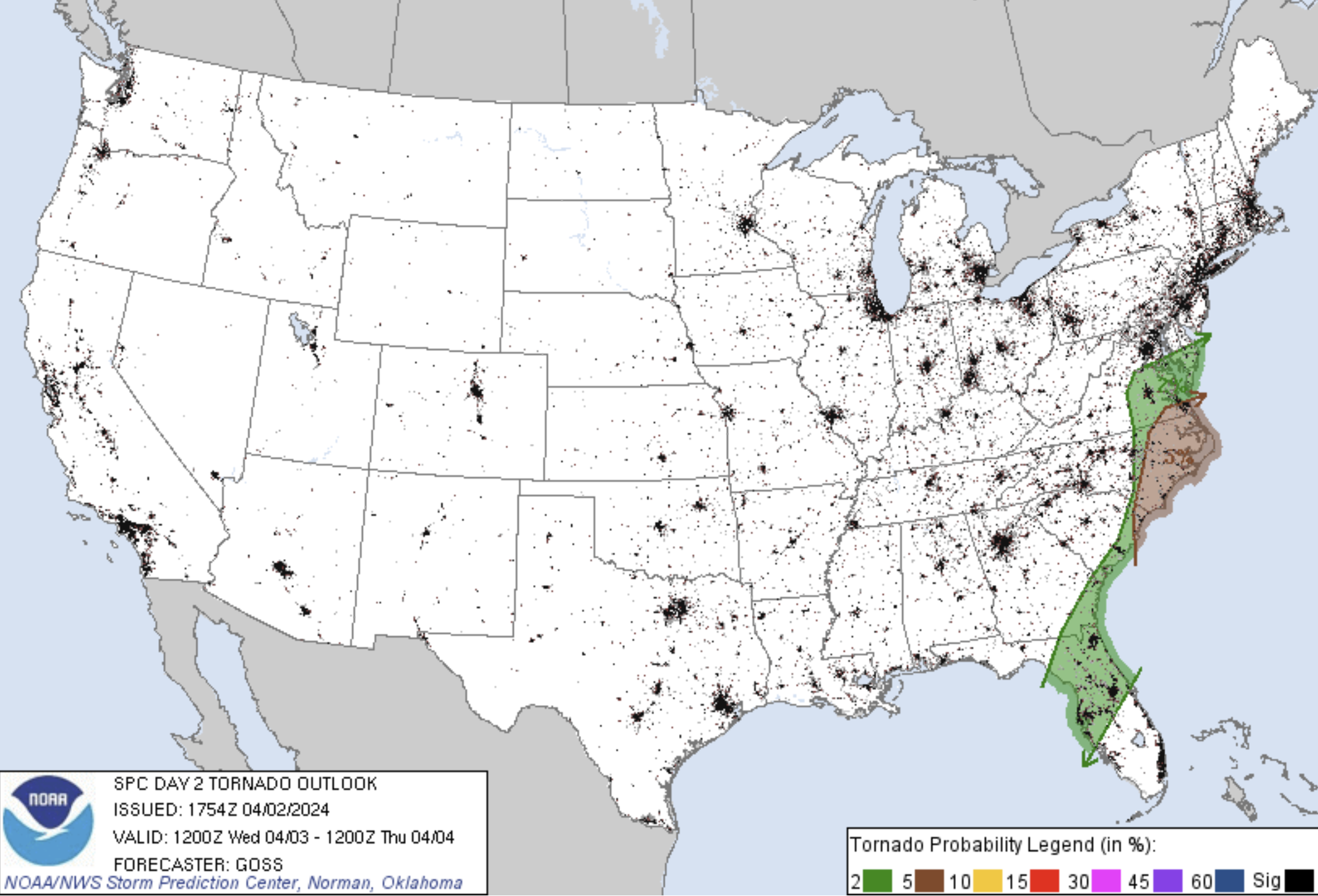
26 minutes ago, GaWx said:
They’ve just increased the tornado threat level somewhat for tomorrow for E NC/far SE VA/far NE SC from 2-5% to 5-10%.
Thanks and I will be amending it
-
 1
1
-
 1
1
-
-
1 hour ago, GaWx said:
Regarding just GA/NC/SC/FL:
Look out for potential tornadoes tonight in much of GA, especially W portion, as well as in the W portions of NC/SC/N FL. The overall threat is higher than it appeared on Sunday when I last posted about this.
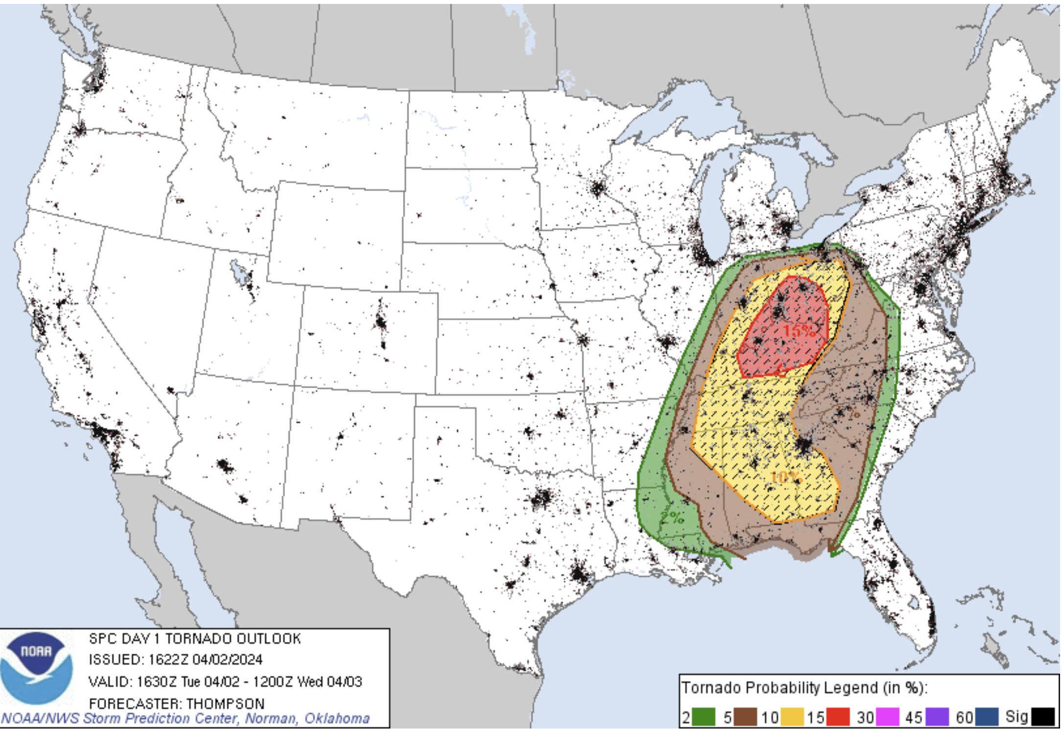
Eastern AL/western GA overnight...
   In response to the amplifying midlevel trough/deepening cyclone over
   the MS/OH Valleys, deep-layer flow and low-level moisture advection
   will increase tonight across AL/GA.  A surge of upper 60s
   boundary-layer dewpoints and strengthening low-level shear both
   appear supportive of supercells/tornadoes overnight in a broken band
   ahead of the synoptic cold front.  An isolated strong tornado or two
   will be possible.

There's a thread for it where all of the storms and potential tornadoes related to this event should be posted:
-
1
-
1
-
-
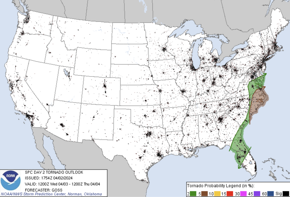
Secondary tornado threat on 04/03 for the Virginia Tidewaters including the Hampton Roads (Norfolk, Virginia Beach, Portsmouth, Hampton, and Newport News) metro, Greater Richmond, The Triangle (Raleigh-Durham-Chapel Hill), Fayetteville, the NC Outer Banks in North Carolina, Myrtle Beach, Charleston, Jacksonville, Savannah, and Greater Orlando and the Tampa Bay area in Florida.
-

Well, it's the first significant threat of severe weather for the regional forum coverage for the 2024 season. This looks to be a late day and potential nocturnal event so let's get to posting here versus the random observations thread.
Major population areas within the tornado threat includes Greater Birmingham, Metro Atlanta, Metro Charlotte, Greenville-Spartanburg-Anderson, and the Piedmont Triad area (Winston-Salem, Greensboro, High Point), and Columbia.
-
There is a boatload of supercells coming off the Atlantic into Southeastern NC near Wilmington. These storms need to be watched very closely over the next few hours because the instability is increasing in that region
-
1 hour ago, kvegas-wx said:
Catawba Cty tornado crossed I40. Panovich tweeted 1 dead, 2 critical. Sad.
I feel like the inability to pick up these type of quick spin-ups is the NexRad Level II radar void in coverage in the Charlotte Metropolitan area counties including Catawba County and the counties areas west of Winston-Salem right outside of Metropolitan Charlotte near Wilkesboro. This is like the third time a quick spin up has been below the RAH, GSP, & CAE NWS radar scans thus no Tornado Warning issued prior to the storm.
-
1
-
-
-
-
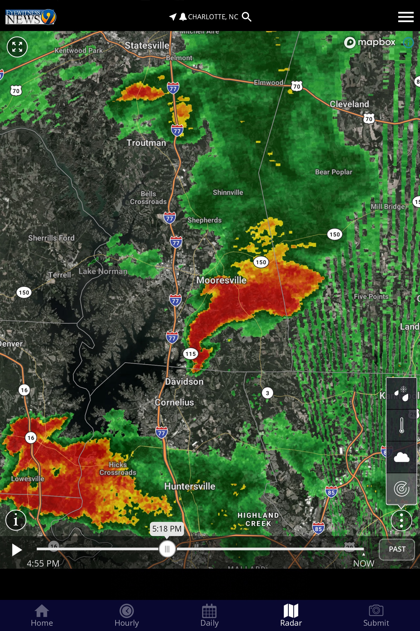
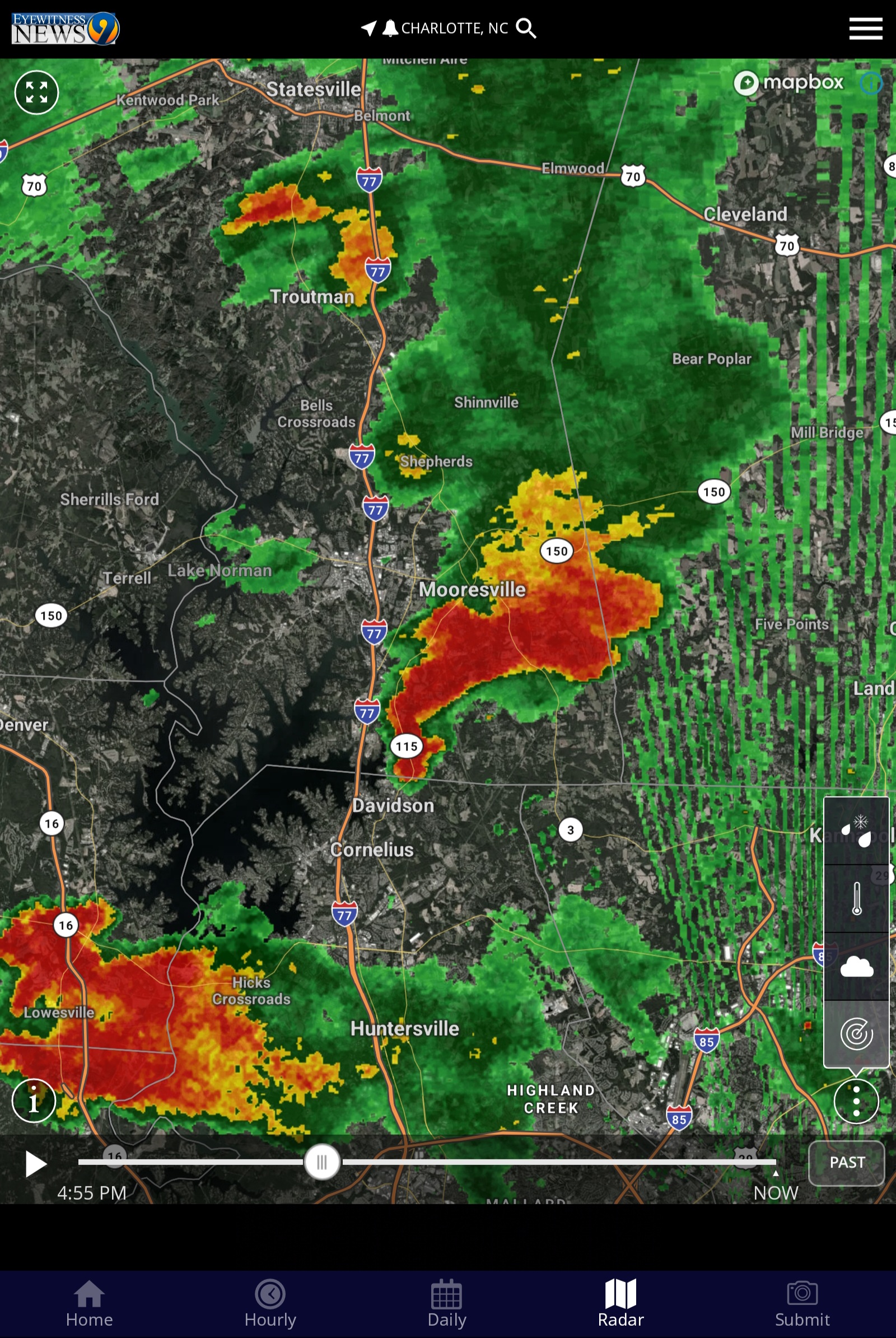
Likely tornado on the ground in Iredell County near Mooresville
-
2 significant tornadoes were spun in West Palm Beach and Virginia Beach yesterday yet nothing about either nor the severe weather threats in the Southeast subforum. Can we please reconfigure the line up of geography from that Southeast subforum retitled to only eastern North Carolina as the most posters seem to not post relevant anything except snow and bizarre IMBY observations in that particular area? We need a more centrally located subforum for the all forms weather across the South outside of the Triangle and Eastern parts of North Carolina.
-
 1
1
-
-
Columbia is in its path
-
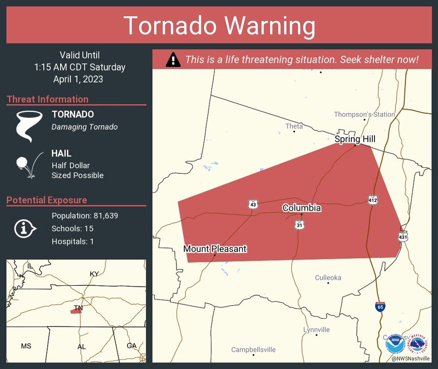
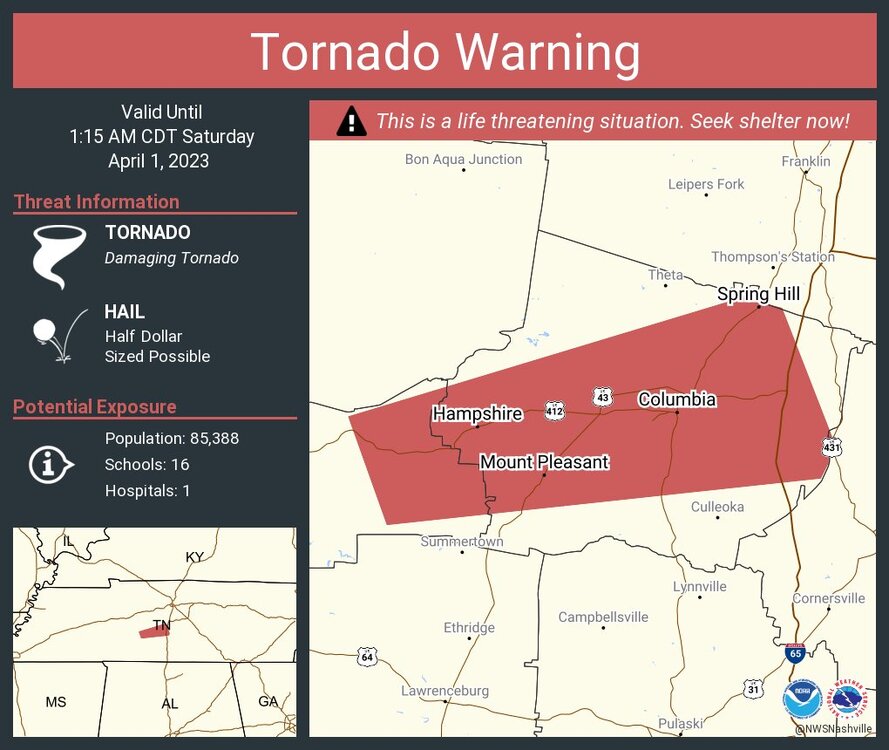
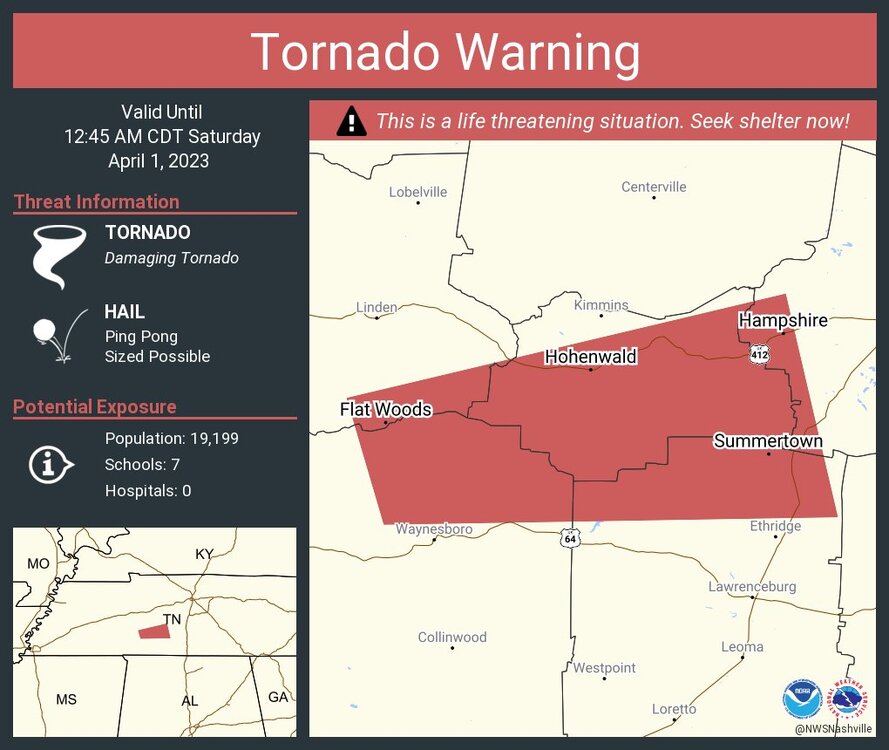
1 minute ago, cheese007 said:
Tornado Warning MSC057-081-117-141-145-010630- /O.NEW.KMEG.TO.W.0063.230401T0546Z-230401T0630Z/ BULLETIN - EAS ACTIVATION REQUESTED Tornado Warning National Weather Service Memphis TN 1246 AM CDT Sat Apr 1 2023 The National Weather Service in Memphis has issued a * Tornado Warning for... Southeastern Union County in northeastern Mississippi... Northwestern Itawamba County in northeastern Mississippi... Northern Lee County in northeastern Mississippi... Southwestern Tishomingo County in northeastern Mississippi... Southern Prentiss County in northeastern Mississippi... * Until 130 AM CDT. * At 1246 AM CDT, a severe thunderstorm capable of producing a tornado was located near Blair, or 10 miles east of New Albany, moving east at 50 mph. HAZARD...Tornado and quarter size hail. SOURCE...Radar indicated rotation. IMPACT...Flying debris will be dangerous to those caught without shelter. Mobile homes will be damaged or destroyed. Damage to roofs, windows, and vehicles will occur. Tree damage is likely. * Locations impacted include... Baldwyn, Saltillo, Guntown, Burton, Wheeler, Pratts Friendship, Blair, Marietta, Blue Springs, Thrasher, Jericho, Branyan, Ellistown, Kirkville, Jug Fork, Hobo Station, Chapelville, Moores Mill, Alpine and Corrona. PRECAUTIONARY/PREPAREDNESS ACTIONS... TAKE COVER NOW! Move to a storm shelter or an interior room on the lowest floor of a sturdy building. Avoid windows. If you are outdoors, in a mobile home, or in a vehicle, move to the closest substantial shelter and protect yourself from flying debris. && LAT...LON 3440 8890 3451 8893 3466 8832 3446 8827 TIME...MOT...LOC 0546Z 257DEG 43KT 3447 8883 TORNADO...RADAR INDICATED MAX HAIL SIZE...1.00 IN $$
These cells are creeping further south and eastward in their tornado warnings
-
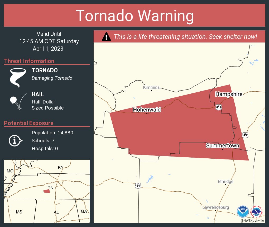
1 minute ago, kayman said:

It's headed towards Columbia, TN in Murray County
-
-
-
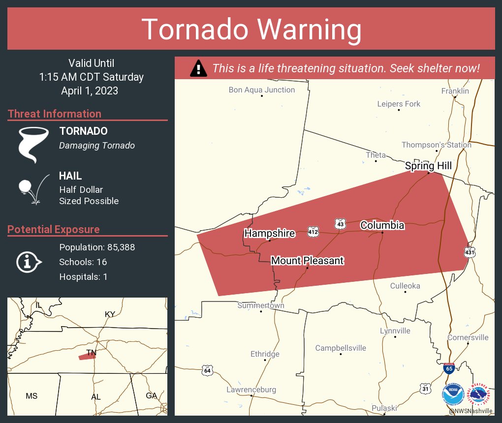
Also the storms headed towards Nashville are now stronger with tornado warnings as well
-
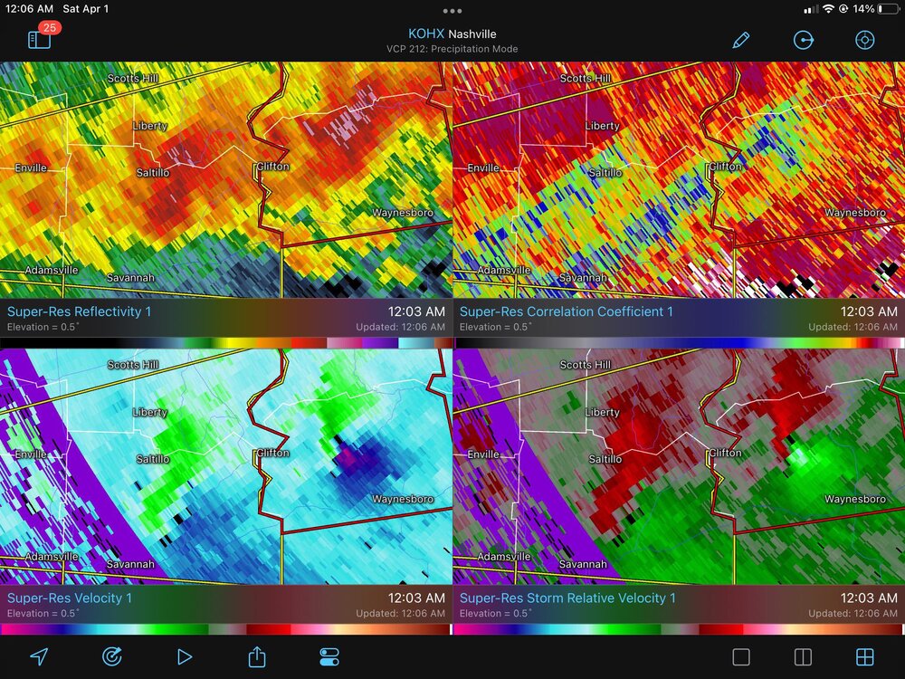
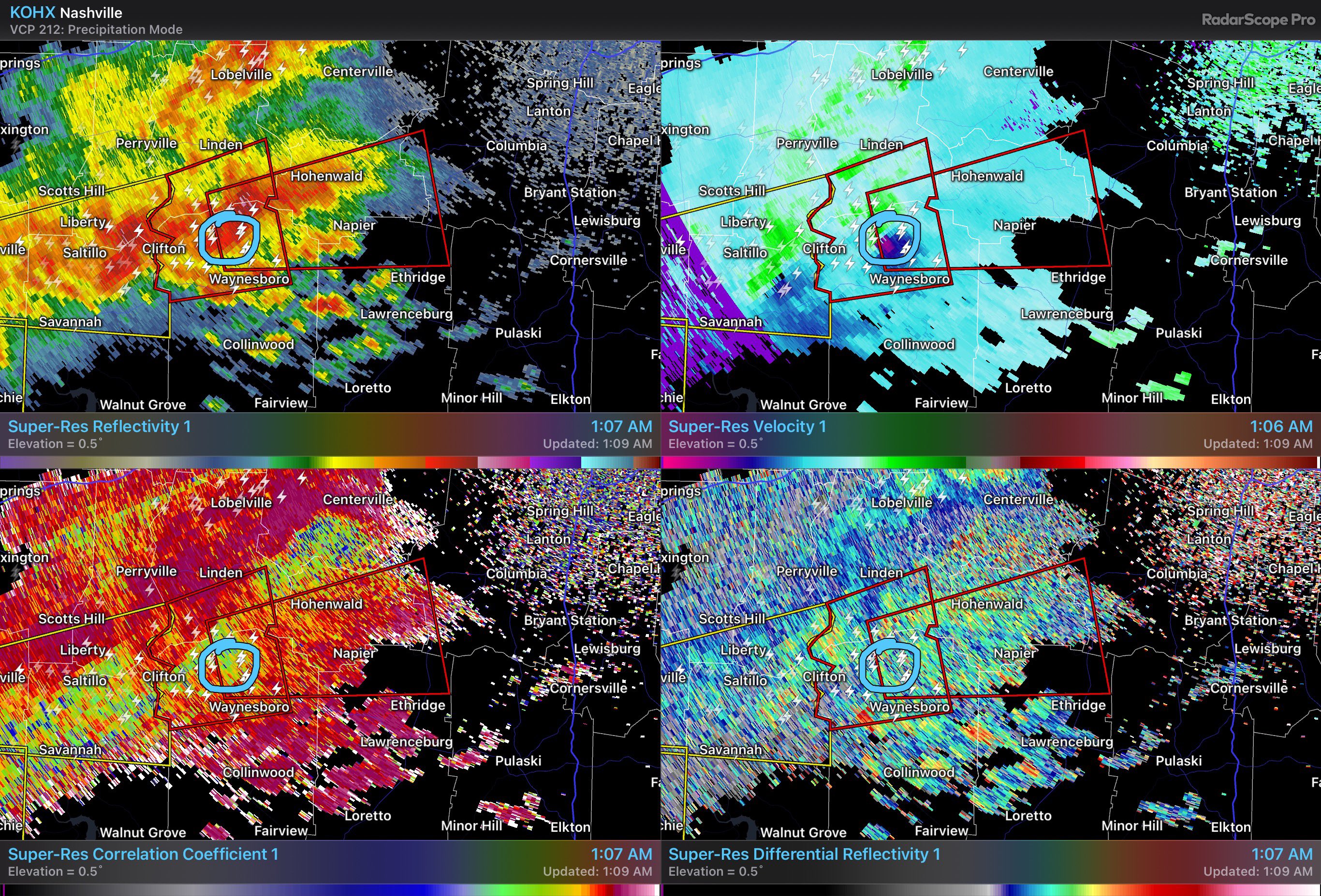
1 minute ago, kayman said:
A large wedge tornado with this storm


Severe Threat 04-02 through 04-03
in Southeastern States
Posted
On GA supercell is tightening up again, likely a TDS is incoming as it approaches Monroe.
GA posters pls advise...