

New England Storm
-
Posts
602 -
Joined
-
Last visited
Content Type
Profiles
Blogs
Forums
American Weather
Media Demo
Store
Gallery
Posts posted by New England Storm
-
-
22 minutes ago, dendrite said:
July 2002 is the last one I remember similar to this, but that had more smoke in the low levels.
I remember that one, the smoke was lower and looked like smoke, vs today with it's hazy sky
-
All I really wanted was rain, all I get is meh and maybe wind
-
Well, some thunder- no rain yet.... Hopefully I get some rain out of this
-
Starting to get windy in Quincy, had a few gusts in the past 30 minutes, made the office take notice
-
Well- if no snow at least we can torch.

-
 1
1
-
-
Saw a load of CG from today's storms in Qunicy Mass, best storm in years for me. Driving home was a bit of a challenge. An hour and thirty minutes for a 20-mile trip.
-
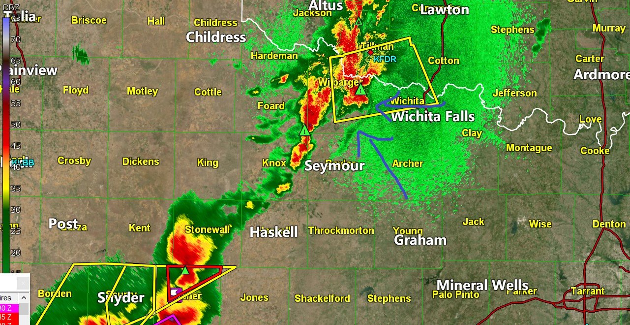
3 minutes ago, NorthArlington101 said:
Storm NW of Wichita Falls is wrapping up and has a pretty untapped (and presumably still stellar) environment to work with.
I dont know- I think it looks kind of outflow-y

-
2 hours ago, NJwx85 said:
Ignore the guidance at your own peril. That massive warmup, if it does come looks transient.
Yeah, I remember hearing a tv met say that the end of May should trend warmer, followed by going back to near normal for early June.
-
I think a poster said that this could be counted as a two day outbreak due to less than 6 hours between tornado touchdowns which means we could be seeing 179 reports of tornado touchdowns
-
Looks like we have the storms in Tn are also becoming dangerous
ULLETIN - EAS ACTIVATION REQUESTED
TORNADO WARNING
NATIONAL WEATHER SERVICE MORRISTOWN TN
917 PM EDT WED APR 27 2011
THE NATIONAL WEATHER SERVICE IN MORRISTOWN HAS ISSUED A
* TORNADO WARNING FOR...
BLOUNT COUNTY IN EAST TENNESSEE...
LOUDON COUNTY IN EAST TENNESSEE...
NORTHERN MCMINN COUNTY IN EAST TENNESSEE...
MONROE COUNTY IN EAST TENNESSEE...
* UNTIL 1000 PM EDT
* AT 913 PM EDT...TRAINED WEATHER SPOTTERS REPORTED A TORNADO 5 MILES
NORTHEAST OF ETOWAH...OR 8 MILES SOUTHEAST OF ATHENS. DOPPLER RADAR
SHOWED THIS TORNADO MOVING NORTHEAST AT 65 MPH.
* LOCATIONS IN THE WARNING INCLUDE...
SWEETWATER...MADISONVILLE...LOUDON...LENOIR CITY...MARYVILLE...
ALCOA...EAGLETON VILLAGE...CITICO...PHILADELPHIA...TARIFFVILLE...
VONORE...CITICO BEACH...GREENBACK...TALASSEE...FRIENDSVILLE...
CLOVER HILL...HAPPY VALLEY...CADES COVE...WALLAND AND TOWNSEND.
PRECAUTIONARY/PREPAREDNESS ACTIONS...
-
Looks like a 2nd rotation west of Tuscaloosa again
Oh god thats not good. That thing is crazy strong srv mode
-
http://www.foxalabamalive.com/
you can see the tornado on the ground Tuscaloosa
omg it is getting larger.
Death of DroughtStein Discussion
in New England
Posted
2.09- not bad!