Trent
-
Posts
2,813 -
Joined
-
Last visited
Content Type
Profiles
Blogs
Forums
American Weather
Media Demo
Store
Gallery
Everything posted by Trent
-
Picked up a half inch of lake effect fluff overnight. As is often the case with east coast bombs, they tend to provide great lake effect set ups for Cleveland. Such a shame that Lake Erie is mostly frozen over, could have been a great event. I noticed that CLE only reported 0.1" of snow yesterday, that would be nearly impossible. The problem wih ASOS in light snow is that the heated snow melters will almost always evaporate the liquid equivalent of these events. I think they just saw the 0.01" that registered as liquid equivalent one hour and marked down a tenth of an inch of snow without much thought.
-
CLE has a partial PNS out for cocorahs 24 hr reports. So for just the clipper part that started yesterday afternoon you've got about 1-2" for the shoreline, 2-4" from about 480 south to Akron, and then a few 5-6" reports in the far south CLE CWA. It was very windy and snow was sugar so I'd expect to see some varied snowfall totals. Quite a bit of drifting going on.
-
Nickels and dimes for sure. Model QPF for this event was extremely overdone and kudos to CLE for taking output and cutting it down. Had about 1.5" of snow, which is sad considering it snowed for about 19 hours straight with visibilities less than 2 miles for most of the time with temperatures hovering around 20. It's always difficult to get long duration synoptic snows here, but when we do just can't get the moisture to work out. Many models were showing a stripe of 0.75" liquid equivalent in the US30 corridor, doesn't look like half that fell. CLE still sitting at average for the season in terms of snow but should start running a deficit soon.
-
I was surprised that the official forecast is only for an inch tonight. NAM, GFS, and Euro all suggest around 3" with much more to the south. With a tendency for these storms to bust low, can't blame a more conservative snowfall total forecast. There will certainly be a tight gradient with this storm. Hopefully we get a little bit of a NW bump overnight.
-
And the GFS paints a very interesting scenario over the next few days as the storm up the east coast develops. Shows 6-10" for much of northeast Ohio over 48 hours. It seems the storm throws quite a bit of moisture back over Ohio and combined with lake enhancement puts down some appreciable accumulations for interior locations closer to the PA border. It'll be interesting to see how this unfolds.
-
QPF amounts were decent yesterday, ratios were not as we hovered around freezing. The little spike in temps in the afternoon allowed for some foggy drizzle that resulted in some compaction. We are nickel and diming our way at normal. Interestingly, this year only has 3" less than last year on the same date. It really doesn't feel like 33" of snow has fallen this winter.
-
CLE reporting heavy snow with an inch in the last hour. Looks like they've had 2 inches so far. The easterly winds with downsloping has really eroded some of the snow as it pushes northeast. If one were to look at the radar since this started, you'd have though the west side would be pushing 4-5" already. Must have been a lot of dry air aloft.
-
Bands have set up nicely on the west side. Flake size seems a bit disappointing thus far and radar looks more impressive than in actuality. Perhaps things will improve in a bit as better returns slide in. I think 2" seems reasonable at this point, especially for areas around Lorain County.
-
I was driving on the Shoreway and it looked like all the ice was gone outside of the typical shore ice. Winds/thaw must have broken it up or pushed it out into the central lakeshore. I'm curious what the visible satellite will look like, it wouldn't shock me if the ice that had formed this past week was quite thin. Temperatures this week don't look as cold as originally forecasted, so perhaps we can keep the central basin somewhat ice free a little bit longer.
-
That's kind of funny. I can't imagine there are many meteorologists that don't find snowfall exciting. It's hard to believe that a degreed meteorologist would prefer 38 and rain over snow in January. I think 95%+ of this board would find 30s and rain the most miserable kind of weather out there.
-
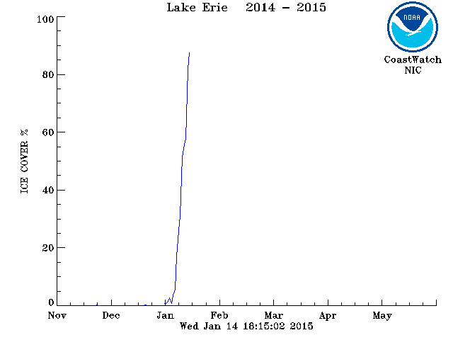
Here is a graph showing Lake Erie ice cover percentages. As you can see, we pretty much went from zero to completely ice covered in a matter of days:
-
Many stations across north central Ohio were in the -10 to -20 range. Just looking at some personal weather stations around Port Clinton, several dipped to near -10, so that -14 doesn't seem unreasonable. Lake Erie near there is likely frozen solid for several feet. Its warming effect is likely quite muted.
-
Visible satellite shows the ice coverage quite nicely this morning, basically Erie, PA and points westward are ice covered. Just 1 degree shy of a record low this morning, but I did notice many inland locales dipped in the -12 to -20 range under ideal radiational cooling conditions. Looking at the Great Lakes Snowfall totals thread, there hasn't been a season that has had as much snow up to this point in the past 2 decades that hasn't had at least 50 inches on the season. I think that bodes well, however ice coverage is alarming. How much enhancement can we possibly get with the ice cover extent? With several more cold nights ahead and next week looking cold as well, the ice is probably here through early March. Last February and March we were fortunate enough to be in an active pattern despite the lack of LES, getting grazed in every direction by storms without a direct hit. Hopefully we'll be as lucky this year, except with a bullseye storm this go around.
-
CLE at 30.3" for the season is still 4.7" above the average for the date. Looks like a boring week ahead, so that total should fall back to around normal before the next threat approaches. The lake will be solid by the end of the week, it's a shame we couldn't have cashed in more from lake effect during December and January.
-
Figures this would be a decent hit! I was gone for the weekend and just got home and completely missed this storm here. It appears I had about 5". I'm surprised this wasn't an advisory. Models were pretty much locked in on a 4-6" event for a good 2 days out across the northern tier of counties. Considering all the other advisories issued this winter for non-events, this was definitely the best synoptic snow of the season.
-
I'd say that I'm not really surprised at today's bust. The wind today was so relentless that it looks like there's actually less snow on the ground than yesterday, before the inch of fluff fell overnight. While not gospel, the hi-res models are pretty good indicators. If none of them are showing any major accumulations, then one shouldn't expect a broad brush of 4-8" and 6-10" that was forecasted. I think the signs had started developing 36 hours prior that this wasn't going to be a big event, but after a week of things looking good, it's hard to back down from that kind of forecast. Perhaps, had last night's band been slower, sitting over areas for 2-3 hours, instead of 20-30 minutes, then accumulations might have just barely hit the low end of the forecast. The best snow producers for CLE are the old fashioned enhancement events, where wave after wave of snow rotates in off Erie. I think the last classic event was back at the end of February 2010. As for this season, I think our best of winter already peaked in mid November. It will probably be hard to top that week for the second half of winter.
-
If the NWS can issue polygon warnings for specific areas for thunderstorms, tornados, and floods, there's no reason not to do it with winter storms and lake effect. I think it would help leaps and bounds for Northeast Ohio and NW PA to be able to have this level of warning compared to the "summer" type events. Particularly in population dense areas of Cleveland it would be nice if the NWS could just add a polygon that included the fringe areas as needed instead of warning a million plus people and setting off a media frenzy. The back side to this is that it puts way more pressure on accuracy. It's not always easy to tell where a band will set up,
-
The Lake Huron connection band should prove to be quite impressive. It'll be interesting to see what kind of totals come out of it. For the rest of northern Ohio, I still think storm totals are way too aggressive. Lorain County is under an advisory for 4-8", unless a significant band develops there, that's going to bust hard. The snow maps out of CLE are showing 12"+ amounts in the eastern suburbs of Cuyahoga, I find it very hard to believe the 271 corridor is getting 10" today. Perhaps we'll be surprised, but I just haven't liked the way this was setting up since yesterday.
-
Well that band collapsed pretty quickly as it passed through. I only had 1" of snow from it, not surprising. Hopefully the east side did better overnight. Looking at radar I'm guessing maybe 2-3" for the eastern burbs? I guess we now wait to see what develops with the NW flow, but I'm doubtful lakeshore and western areas are coming in anywhere close to the 4" minimum in the advisory.
-
I've been feeling quite pessimistic regarding this lake event. None of the BUF HiRes models show anything terribly noteworthy for the next 36 hours and the NMM and ARW aren't showing a great deal either. Not that these models are the be all end all with snow forecasting, but I'd feel more comfortable if one of these models was sniffing out larger 0.5"+ liquid equivalent totals in the traditional snow belt areas of NE Ohio. I'm hoping this is another case where the hires models aren't picking up on something. Regardless the morning commute on Wednesday should be rough, so any warnings and advisories will probably verify based on travel impact.
-
Had about an inch, as expected. CLE had 0.09" inches liquid equivalent on the metar, but climate report shows only 0.04". That seems to happen quite a bit. Very odd to see the metar totals reduced in snow events, normally they under report and need to be beefed up. CLE is being too aggressive with snow totals tomorrow in my opinion, particularly for lake shore areas. I'll be shocked if more than 3" falls near the lake from downtown and points west. But as always with lake effect, anything can happen.
-
CLE's snow map for hours 36-42 looks similar to what I mentioned before - a far east and far west side band. CLE also mentions the Huron connection in their discussion below. It seems that whenever a Huron connection develops, it's harder for this band to make it any further west than Ashtabula County. Then you tend to get that "secondary" smaller band just far away from the primary band that develops from Lorain southeastward. In between the two, you really miss out on the good stuff. I'm hoping that doesn't play out like that with this event as it misses most. HIGHER RESOLUTION MODELS ARE INDICATING A DOMINANT LAKE HURON BAND EXTENDING ACROSS LAKE ERIE INTO NE OHIO. EXACT PLACEMENT IS HARD TO DETERMINE AT THIS TIME ALTHOUGH ASHTABULA COUNTIES LOOKS LIKE THE MAIN AREA. AREAS OUTSIDE OF THIS BAND MAY ONLY SEE ADVISORY LEVEL SNOWS.
-
Wow. They definitely aren't going conservative with totals even when you factor in 2" of clipper snows overnight. We're still a good 30 hours out, so lots of time for fine tuning the parameters. I'm sure lake effect watches will go out soon
-
It'll be interesting to see if Wednesday unfolds with several small bands, a single band, or a general blob of snow. Many times with a NW flow, the orographic lift really sets off the snow along and south of 480. However, there also tends to be one of those narrow bands that develops through Lorain County down to around Strongsville and then Northern Medina through Richfield and Northern Summit. Similarly another tends to form through Lake County and into Geauga. I've seen these situations in the past where the bands don't move much and if you're under them you do great, but if you're between bands, you might escape the event without much. There'll probably be a lot of now casting on Wednesday. It's unfortunate the clipper has trended less impressive run after run, that would have made a great base.
-
BKL surging with downsloping. Up to 55 there. There's a tight temp gradient between Toledo and Sandusky. I noticed that some places around Sandusky rose from the mid 30s to low 50s in a matter of minutes in the past hour when the warm front pushed through and winds shifted. Hopefully that continues to push a bit more towards Toledo overnight.