

metalicwx366
-
Posts
7,071 -
Joined
-
Last visited
Content Type
Profiles
Blogs
Forums
American Weather
Media Demo
Store
Gallery
Everything posted by metalicwx366
-
Yeah, I’m hoping we get a big Lake (Sea) Effect snow event here this year. Usually favors the areas south of us, but we can cash in sometimes. Japan is a beast when it comes to Sea effect snow. They receive insane amounts of snowfall.
-
Yeah lol. 3 years in Hawaii was nice with the trade winds where it’s almost always windy. Other than that, weather was lame with a few fun events thrown in there.
-
It’s quiet in here. I haven’t been on much in the last year either. So excited to see snow this year in Korea.
-
Onwards to Korea in a few months.
-

Mid to Long Term Discussion 2019
metalicwx366 replied to Upstate Tiger's topic in Southeastern States
I thought this was pretty cool to see in NWS Jacksonville discussion. “Mainly dry conditions were occurring across interior southeast Georgia, and only a few hundredths of an inch are possible in this region tonight. The radar this evening was showing enhanced reflectivities across the Suwannee River basin and Alachua County, but this is due to bright banding. Bright banding is relatively rare in our area, and this is due to snow melting as it is falling aloft, with a film of water on the melting snowflake causing the radar to see it as a giant raindrop or small hail. By the time it reaches the surface, the precip is just a cold rain. The radar, however, will overestimate precipitation in the bright banding areas, so will have to rely on observations.” -
Crazy rainfall event ongoing down there. Been raining nonstop since Saturday night. Waycross has gotten like 9 inches of rain so far. Lots of street flooding pictures I’ve seen today.
-
Lol they just gave the all clear here. Now everyone is returning all their water and other supplies they bought.
-
Yep, radar starting to fill in slowly. 0Z GFS and HRRR still showing the potential of some significant rainfall with a heavy band of rain that sets up over the area tomorrow. Sort of reminds me of Darby from 2016 when we got significant flash flooding after the system passed when flow turned southerly.
-
What kinda winds are you seeing there? We just gusted up to 40MPH. Rain we are getting currently still associated with wet trades.
-
No. Not one band of rain associated with Lane has made it up here without falling apart.
-
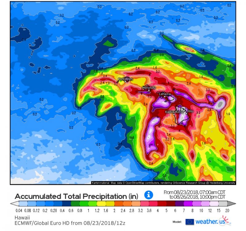
Yeah I’m pretty much done with it now. Any significant rain won’t happen till tomorrow late morning or afternoon looks like. Been one hell of a storm for Big Island and Maui rainfall wise though. Insane rainfall totals over there.
-
Yeah, but we probably aren’t going to see anything on the leeward side lol. 0.04 so far. Decent winds here though. Need quite a bit more to reach those 8-12 inches of rain.
-
Yeah it’s finally raining here.
-
Lol the 0Z CMC keeps this storm well to the south of us. Models still can’t agree when we are 24 hours from potential landfall. Just had a gust up to 38MPH otherwise nothing too crazy right now.
-
That’s what I was saying earlier. The models don’t really show any significant rain for a while. Where are you at getting SE winds? Still NE here and definitely picking up.
-
I’m seriously having doubts about that 8-12 inches of rain here. Especially if this thing tracks towards Maui/Big Island. We stay on the dry NW side. Darby we didn’t get any rainfall until after the storm passed when the flow became southerly.
-
Here are the rainfall totals through Sunday. About 5-7 inches of rain for us.
-
Nah, I have to disagree with this. This was earlier this year from 3-5 inches of rain in a couple of hours.
-
Nope. Takes it basically on the same path as the latest GFS and GALWEM model runs. So much uncertainty/model disagreement 24 hours out from the event. We basically just went with the westward track and discounted all the models that show this getting sucked up into the big island or Maui,
-
My phone just sounded off really loudly. Didn’t even receive a notification.
-
I’m right outside the Hickam AFB. Trying to go storm chasing?
-
Shhh.... No you didn’t.
-
So busy here at work. Dealing with Lane, and the other two typhoons hitting Korea and Japan all on the same day. So glad I don’t work Friday and Saturday. Friends at JTWC also can’t catch a break. They aren’t taking chances here especially considering what happened at Guam with typhoon Maria last month.
-
The panic has already started here. We are in TCCOR 4 which means there is the potential for destructive winds within 96 hours. It disseminates to the entire installation, so people are already out and about getting supplies, water , and the usual.
-
So much hype here for Hurricane Hector. This happens everytime. It’s clear it won’t hit us unless we get some dramatic northward shift, but all the news channels are hyping up a hurricane hit.


