

RodneyS
-
Posts
1,254 -
Joined
-
Last visited
Content Type
Profiles
Blogs
Forums
American Weather
Media Demo
Store
Gallery
Posts posted by RodneyS
-
-
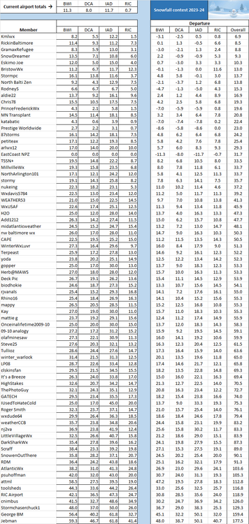
April showers have arrived in the Mid-Atlantic, but it is rather obvious that they will not produce any measurable snow. So, it is time to award the 2023-24 Championship Trophy to Kmlwx. He was the second entrant on the day that the contest opened on 11-1-2023, but his "shot in the dark" hit the bullseye, as he accurately forecast not only another quiet snow season in the Mid-Atlantic, but also nailed the wide disparity between the snow total at Richmond and BWI/Dulles. RickinBaltimore would have walked away with the trophy if RIC were excluded, but he labored under the illusion that the airport is still located in Virginia, having missed the news that it was recently relocated to Richmond County, Georgia . . . Okay, that's an April Fool's joke, but it does seem that way regarding snow.
So, congratulations to Kmlwx, and the rest of us will try again this November.

-
 8
8
-
 1
1
-
-
On 2/29/2024 at 6:38 PM, RodneyS said:
Precipitation at DCA slowed way down in February, coming in at only 1.41 inches, which made it the 22nd driest of 154 Februaries in DC history. However, the meteorological winter total at DCA was 13.72 inches, making it the 12th wettest in DC history.
Precipitation at DCA rebounded in March to 4.89 inches, making it the 26th wettest in DC history. Moreover, December 2023-March 2024 precipitation at DCA totaled 18.61 inches, making it the 10th wettest in DC history and the wettest since 1993-1994, which totaled 21.31 (4th). The wettest December-March is 1890-91, which totaled 23.21.
-
3
-
-
On 3/20/2023 at 9:07 PM, RodneyS said:
The 2022-23 astronomical winter (December 21-March 20) and composite winter (December 1-March 20) at DCA followed suit, with each also coming as the third warmest in DC history. The former averaged 44.8 degrees, behind only 2011-12 at 45.9 and 2019-20 at 45.5. The latter averaged 44.3 degrees, behind only 2011-12 at 45.6 and 2019-20 at 44.6.
The 2023-24 astronomical and composite winters were each warmer than last season at DCA. The former displaced last season as the third warmest in DC history, averaging 45.2 degrees; while the latter displaced 2019-20 as the second warmest in DC history, averaging 45.1 degrees.
-
2
-
-
44 minutes ago, GramaxRefugee said:
At this time of year, a heavy snow would be melted in a few days anyway. Winning Glory Never Melts.
However....2.5 inches at RIC, with a little bit at IAD would suit me fine.
You need at least 0.2 inches at IAD to pass RickinBaltimore, and 1.3 inches there would pull you within 0.3 of Kmlwx. If the latter happens, an inch at RIC could do it for you. I think 1.3 at IAD is much more likely than 1.0 at RIC, but you never know.
-
2
-
-
23 minutes ago, Kmlwx said:
I'm torn on whether to root for a last minute freak snowstorm that makes me lose....or if I should just hope for the win at this point.
I hope to have that dilemma next March.

-
1
-
-
1 hour ago, Kmlwx said:
I had not been checking the thread - I thought for sure I would be out after the little snow event. Goes to show you weather is a lot of guesswork...my entry was a total shot in the dark.
Nice shot - especially in foreseeing the large gap between RIC and the other three airports.
Day-by-day, the clock is ticking in your favor.
-
17 hours ago, RodneyS said:
Precipitation at DCA slowed way down in February, coming in at only 1.41 inches, which made it the 22nd driest of 154 Februaries in DC history. However, the meteorological winter total at DCA was 13.72 inches, making it the 12th wettest in DC history.
While precipitation slowed at DCA in February, the warmth continued, with an average temperature of 44.4 degrees -- 7th warmest February in DC history. That brought the meteorological winter average to 43.2 degrees -- also 7th warmest in DC history. So, the 2023-24 DCA meteorological winter is easy to summarize -- warm and wet.
-
1
-
2
-
-
DCA _ NYC _ BOS __ ORD _ ATL _ IAH __ DEN _ PHX _ SEA
1.6 2.5 2.5 1.3 0.4 1.3 -0.5 -1.5 -2.1
-
1
-
-
On 1/31/2024 at 6:36 PM, RodneyS said:
The precipitation slowed at DCA over the past three weeks, but still managed an additional 2.62 inches, to bring January precipitation there to 5.88 inches, good enough for the 7th-most in DC history. Moreover, the December-January total is now 12.31 inches, which is the most to start a meteorological winter in 87 years. That December 1936-January 1937 produced 13.06 inches in DC, and the only December-January to exceed that was way back in 1881-82, which recorded 13.21 inches.
Precipitation at DCA slowed way down in February, coming in at only 1.41 inches, which made it the 22nd driest of 154 Februaries in DC history. However, the meteorological winter total at DCA was 13.72 inches, making it the 12th wettest in DC history.
-
On 2/28/2024 at 3:14 PM, Rhino16 said:
So... I downloaded some ERA5 Reanalysis data, 80 years worth from 1945-2024, found the average temperatures and then found the change in average temperature between the 2 40 year periods. I then plotted it and these are the results for both days. There's definitely something happening around our part of the country and north on the 13th... what exactly, I don't know.
Excellent.
 I'm delighted that you are extending my analysis to include additional areas.
-
1
-
-
1 hour ago, southmdwatcher said:
January 25, 2000, is the greatest surprise snow event in the last 40 years. My memory is that we and the whole Northeast had a busted major storm/blizzard. After the busted blizzard, the weather was fine, but there was an outbreak of thunderstorms across the Southeast on the 24th. The weather forecast was still not indicating snow for the Mid Atlantic. However, THE sign was friends of mine from Charlotte NC, calling me early that afternoon on January 25, 2000, saying they were supposed to be 50 degrees with a few showers, and it was snowing heavily, with major accumulation. Radar continued to show the snow moving more northward than northeast. Our forecast was for a few flurries in DC and maybe minor accumulations up to an inch east of DC. Well, early evening the TV's all belted out the Winter Storm Warning's with accumulations of 8 to 12 inches and we still beat that. Still as amazing and surprising as that event was, PD1 on February 19, 1979, absolutely slammed that overnight.
The Tuesday, January 25, 2000 snowstorm was a big surprise . . . until a new model run around 9:30 PM Monday evening. I remember Channel 5 (DC) meteorologist Sue Palka leading the 10 PM News that evening with the major update to the forecast. However, the Office of Personnel Management was not sure whether to believe the update, and so initially ordered the Federal Government to open. Wisely, they reversed themselves around 7 AM on Tuesday and shut it down. DCA received 9.3 inches that day and IAD received 10.3 inches.
-
1
-
-
12 hours ago, MDstorm said:
I was a youngster when that storm occurred. However, I distinctly remember that on Feb 17th (24-36 hours before the storm even began), AccuWeather was the first to see the possible magnitude of this storm. The NWS and most private forecasters were not making a big deal about the storm. Channel 11, which used AccuWeather at that time came on the air on the evening of Feb 17 and reported a "storm" dropping in from the Ohio Valley looked to explosively re-develop off the NC coast and result in a major snowstorm. The following morning (Sunday), everyone's favorite met, Joe Bastardi, was on the radio and was quite emphatic about the huge potential of that storm (he did nail that one,
). There was one private forecaster on the now defunct WCAO radio station who said during the morning of Feb 18th that he was not overly impressed with the storm, but later came back on in the afternoon and stated that he was stunned by the latest information that he had seen and he was all in for a big storm. (I don't think that it was the RAP or HRRRRRR  ). Anyway, with up to 4 inches of cold powder per hour for a few hours, the snow piled up to historic levels and I had over a week off of school.
I agree with you about AccuWeather, but I wasn't aware of its forecast until after the storm, when it began to receive favorable publlcity about its call.
-
2 hours ago, dailylurker said:
Is this the one where it was almost 70 degrees the next day?
No, but there was a significant warmup over several days with lots of rain, and the snow at DCA was gone in about a week. Here are the DCA minimum and maximum temperature readings, precipitation (and snow for the two days of the storm), and ground snow measurements, beginning with the day the storm started:
2-18-79: 6 and 15; 0.21 (4.7 snow); 6
2-19-79: 12 and 36; 1.16 (14.0 snow); 18
2-20-79: 10 and 40; 0; 22
2-21-79: 27 and 43; 0.07; 17
2-22-79: 33 and 56; 0; 12
2-23-79: 35 and 44; 0.20; 7
2-24-79: 38 and 45; 1.67; 4
2-25-79: 39 and 45; 1.12; 1
2-26-79: 38 and 41; 0.09; 0
-
1
-
1
-
-
7 hours ago, RickinBaltimore said:
See we just need a southern snowfall now...
You don't even need that if you get the 0.1 inch you need to nail BWI and the 1.3 inches you need to nail DCA.
-
This article notes that Delaware received nearly 25 inches. https://vlab.noaa.gov/web/nws-heritage/-/unpredictable-the-president-s-day-storm-of-1979#:~:text=By Monday%2C February 19%2C snow,blocked%2C impassable even to snowplows.
What was memorable about that Sunday prior to the storm was the extreme cold -- the temperature ranges were 6 to 15 at DCA and -14 to 8 at IAD.
-
1
-
-
For those of us of a certain age, the answer to the question of "your most memorable snowstorm" is a no-brainer. Nothing comes close to this one because it was so unexpected, as detailed here: How the surprise President’s Day snowstorm of 1979 advanced forecasting - The Washington Post. When I went to bed on the evening of Sunday, February 18, 1979 (February had the same calendar that year as in 2024), I expected to wake up to a coating of 2-3 inches. Instead, when I woke up on Presidents' Day, I literally could not see my car! What was equally extraordinary is that people in the Reston neighborhood where I lived came out en masse that morning to take it all in, and everyone was in an upbeat mood. No one could quite believe that we had received that much snow (officially 18.7 inches at Reagan National Airport -- the most in DC since the January 27-29, 1922 Knickerbocker Storm), when little had been forecast.
Since then, there have been larger storms in the Maryland and Virginia suburbs, but none compare to this one for emotional impact.
-
6
-
-
This Presidents Day weekend storm did not quite live up to billing, but did produce 2.2 inches at BWI, 0.1 at DCA, and 1.1 at IAD. That enabled RickinBaltimore to move into second place behind Kmlwx. A very competitive leaderboard, but will the Mid-Atlantic receive any more snow this season?

-
2
-
1
-
-
Somewhere along the way, IAD's snow total for January was revised upward by 0.2 inches, and today IAD added another 0.6 inches. Those changes move SnowDreamer and RickinBaltimore into stronger contention, while eliminating me.
 Kmlwx and GramaxRefugee are still the Top Two and both benefited from no measurable snow today at BWI and DCA.
-
3
-
-
On 1/10/2024 at 3:30 PM, RodneyS said:
Interesting note from the Capital Weather Gang: "The 2.24 inches at Reagan National Airport, 1.76 inches at Dulles International Airport, and 2.62 inches at Baltimore-Washington International Marshall Airport were all record amounts for the date. That brings Washington’s total rainfall to 9.69 inches since Dec. 1, well past the previous high of 7.56 inches during the same period in 1901-1902, according to Capital Weather Gang’s Ian Livingston." See https://www.washingtonpost.com/weather/2024/01/10/dc-storm-flooding-record-rainfall
The precipitation slowed at DCA over the past three weeks, but still managed an additional 2.62 inches, to bring January precipitation there to 5.88 inches, good enough for the 7th-most in DC history. Moreover, the December-January total is now 12.31 inches, which is the most to start a meteorological winter in 87 years. That December 1936-January 1937 produced 13.06 inches in DC, and the only December-January to exceed that was way back in 1881-82, which recorded 13.21 inches.
-
1
-
1
-
-
DCA _ NYC _ BOS __ ORD _ ATL _ IAH __ DEN _ PHX _ SEA
0.3 1.9 1.0 3.5 0.0 1.8 0.8 -1.3 -0.2
-
11 hours ago, RodneyS said:
My research indicates that January is the only month in DC history where the two highest temperatures of a month have fallen on the same day. Here is the complete list:
I have updated the list to add the lowest and second lowest temperatures of each month in DC. Note how -- while record high temperatures have occurred more frequently in recent years -- they encompass essentially the entire period of record (1872-2024). On the other hand, with a few exceptions, record low temperatures occurred almost entirely in the old days.
January: Highest -- 26th of 2024 (80); second highest -- 26th of 1950 (79)
January: Lowest -- 1st of 1881 (-14); second lowest -- 14th of 1912 (-13)
February: Highest -- 25th of 1930 (84); second highest -- (tie) 21st of 2018 and 28th of 1948 (82)
February: Lowest -- 11th of 1899 (-15); second lowest -- 10th of 1899 (-8)
March: Highest -- 23rd of 1907 (93); second highest -- 29th of 1907 (92)
March: Lowest -- 4th of 1873 (4); second lowest -- 5th of 1872 (5)
April: Highest -- (tie) 17th of 2002, 18th of 1976, 23rd of 1960, and 27th of 1915 (95)
April: Lowest -- 1st of 1923 (15); second lowest -- 19th of 1912 (22)
May: Highest -- 31st of 1991 (99); second highest -- 30th of 1991 (98)
May: Lowest -- 11th of 1906 (33); second lowest -- (tie) 9th of 1947 and 1st of 1876 (34)
June: Highest -- 29th of 2012 (104); second highest -- (tie) 9th of 2011 and 9th of 1874 (102)
June: Lowest -- 2nd of 1897 (43); second lowest -- (tie) 1st of 1938, 1st of 1930, 11th of 1913, 9th of 1913, 9th of 1912, 3rd of 1910, 9th of 1891 (45)
July: Highest -- 20th of 1930 (106); second highest -- (tie) 7th of 2012 and 10th of 1936 (105)
July: Lowest -- (tie) 4th of 1933, 4th of 1907, 31st of 1895 (52)
August: Highest -- 6th of 1918 (106); second highest -- 17th of 1997 (105)
August: Lowest -- (tie) 29th of 1986, 31st of 1934, and 24th of 1890 (49)
September: Highest -- 7th of 1881 (104); second highest -- 2nd of 1980 (101)
September: Lowest -- 23rd of 1904 (36); second lowest -- (tie) 30th of 1912 and 26th of 1879 (38)
October: Highest -- 2nd of 2018 (98); second highest -- 5th of 1941 (96)
October: Lowest -- (tie) 31st of 1917, 31st of 1893, 30th of 1873 (26)
November: Highest -- 1st of 1974 (86); second highest -- 2nd of 1971 (85)
November: Lowest -- 30th of 1929 (11); second lowest -- (tie) 23rd of 1880 and 22nd of 1880 (12)
December: Highest -- 7th of 1998 (79); second highest -- 6th of 1998 (78)
December: Lowest -- 31st of 1880 (-13); second lowest -- 30th of 1880 (-7)
-
2
-
-
On 1/27/2024 at 12:54 PM, MN Transplant said:
Rodney, I wonder how many times the top two temperatures for a month have happened on the same date. We had that oddity yesterday with 1/26/50 previously being the high for the month.
My research indicates that January is the only month in DC history where the two highest temperatures of a month have fallen on the same day. Here is the complete list:
January: Highest -- 26th of 2024 (80); second highest -- 26th of 1950 (79)
February: Highest -- 25th of 1930 (84); second highest (tie) -- 21st of 2018 and 28th of 1948 (82)
March: Highest -- 23rd of 1907 (93); second highest -- 29th of 1907 (92)
April: Highest -- (tie) 17th of 2002, 18th of 1976, 23rd of 1960, and 27th of 1915 (95)
May: Highest -- 31st of 1991 (99); second highest -- 30th of 1991 (98)
June: Highest -- 29th of 2012 (104); second highest (tie) -- 9th of 2011 and 9th of 1874 (102)
July: Highest -- 20th of 1930 (106); second highest (tie) -- 7th of 2012 and 10th of 1936 (105)
August: Highest -- 6th of 1918 (106); second highest -- 17th of 1997 (105)
September: Highest -- 7th of 1881 (104); second highest -- 2nd of 1980 (101)
October: Highest -- 2nd of 2018 (98); second highest -- 5th of 1941 (96)
November: Highest -- 1st of 1974 (86); second highest -- 2nd of 1971 (85)
December: Highest -- 7th of 1998 (79); second highest -- 6th of 1998 (78)
-
2
-
-
Today, January 26, 2024, Reagan National Airport shattered the DC record for the earliest 80-degree reading of the year by 26 days. DCA reached exactly 80 today, and the previous record-holder was February 21st (2018), which reached 82. Similarly, while Dulles International Airport fell a degree short of 80 today, it shattered the IAD record for the earliest 79-degree reading of the year by 26 days. Again, the previous record-holder was February 21, 2018, which reached 80 at IAD.
-
When I initiated this thread 11 years ago today, I wrote, regarding officially-reported DC temperatures for two days in January: "January 13th has gone from being the coldest January day at 33.3 degrees on average during 1872-1983 to the warmest January day at 40.3 degrees on average during 1984-2013 -- an increase of 7.0 degrees. January 21st has been the mirror image of January 13th -- going from the second warmest January day at 36.8 degrees on average during 1872-1983 to the coldest day of the year at 32.1 degrees on average during 1984-2013 -- a decrease of 4.7 degrees."So what has happened during the last 11 years? Essentially, a repeat of 1984-2013, but with slightly warmer temperatures for the two days. January 13th this year at DCA averaged 44.5 degrees, to bring the 2014-2024 average for that day to 41.5 -- 1.2 degrees warmer than 1984-2013. January 21st this year at DCA averaged 27.5 degrees, to bring the 2014-2024 average for that day to 33.6 -- 1.5 degrees warmer than 1984-2013.Thus, instead of January 13th and January 21st temperatures at DCA each regressing to the mean January 13-21 temperature over the past 11 years, which would be likely if the prior 30 years had been a statistical aberration, January 13th has continued to be abnormally warm, while January 21st has continued to be abnormally cold. That suggests that this "thaw-freeze" situation in DC is caused by a repeating weather phenomenon, likely relating to warming temperatures worldwide. But what is the specific mechanism that is responsible for this phenomenon?
-
5
-
1
-


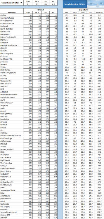
April 2024 temperature forecast contest
in Weather Forecasting and Discussion
Posted
DCA _ NYC _ BOS __ ORD _ ATL _ IAH __ DEN _ PHX _ SEA
-0.3 1.1 0.9 -0.1 -0.2 1.1 0.6 -1.9 -0.2