jpeters3
-
Posts
736 -
Joined
-
Last visited
Content Type
Profiles
Blogs
Forums
American Weather
Media Demo
Store
Gallery
Everything posted by jpeters3
-
Rainfall totals like this probably happen there once a year (Hilo is one of the rainiest cities in the US). Hopefully this means the soil/infrastructure/ground substructure can handle what's to come...
-
Correction, this run has landfall on Lanai and then Molokai as Major.
-
This is kind of an ignorant post. The big island is the second most populated island, with over 100,000 people. Though HNL is the most populated island, there is still plenty of population and infrastructure on Maui and the Big Island. The central and SW coasts of Maui and the western coast of the Big Island are particularly vulnerable.
-
Yep. You can see the southeasterly shear blowing cloud tops toward the NNE in the lower-left part of the AVN loop.
-
I'll bet CPHC is a bit more used to relying on DT/ADT numbers than NHC (at least for the atlantic). ADT numbers are still ~ 130 kt, which is probably why they are staying conservative. Regardless of the official intensity, the actual intensity is what it is. Their decision is a bit questionable, but the official forecast has no impact on what the actual intensity is.
-
Ugh. You're right. That's probably an unfavorable scenario. Can't really win at this point.
-
Ugh! Given the unfavorable wobble over Dominica, maybe we'll get a favorable wobble offshore (or westward) upon landfall away from San Juan and population. A guy can hope...
-
HMON pressures are not reliable. HMON predicted something like 857 mb over the FL keys with Irma, which didn't even come close to happening.
-
Yeah - the average wind from ~ 900 hPa to ~ 920 hPa was greater than 160 kts. Pretty incredible.
-
That's still pretty spectacular, given that it was the SW eyewall. And it hit the surface at 921 hPa, which suggests to me that the center might have gone below 909.
-
Does this graphic show 10s average or gust?
-
I don't typically use this site, but is this forreal? 168 kt at surface?
-
Agree. I for one appreciate the Raw T updates (they save me from having to go look them up myself!)
-
This sort of discussion is probably better left to seismologists, and not weather weenies like us.
-
Some degree of low-cloud cover is common, even among the most intense hurricanes. This probably because subsidence cannot penetrate into the boundary layer, so you get a thermal structure with a warm moist boundary layer, and a warm cap a few km up. Below that cap, shallow convection is possible.
-
I noticed this with Andrew, where the eyewall "ring" on radar actually looked like it fit inside the eye visible in infrared imagery.
-
Recon is currently entering the outer circulation
-
For the sake of comparison, Patricia had a raw T of 8.3 after its bout of rapid intensification, with 190 kt (current storm is up to 7.3). Your estimate could actually be realistic.
-
This post is ignorant and uncalled for. This storm is clearly rapidly intensifying (rather than simply fluctuating to a temporary high T value).
-
Raw T to 7.1. That's higher than it ever was for Wilma.
-
Fortunately, preparations for a 115 kt storm are pretty much the same as those for a 130-140 kt storm (which is probably closer to reality). GTF away from low-lying areas, take shelter from debris.
-
Regardless of the advisory intensity, the storm's actual intensity is what it is - and Dominica is about to feel the full brunt of it. Was really hoping this storm could threat the needle between islands :-( 2003 census puts the population at 71,727.
-
Raw T is up to 6.9 right now. Given the satellite presentation, I wouldn't be surprised if we have a borderline cat 5 on our hands, and after what was probably a very rapid deepening. Wilma experienced a very similarly rapid jump in raw T to 7.0 (below is from Wilma) 5OCT18 221500 4.6 983.0/ +5.8 / 79.6 4.6 4.6 4.6 4.6 NO LIMIT OFF -67.86 -71.70 UNIFRM N/A 16.73 81.55 SPRL 2005OCT18 224500 4.6 983.0/ +5.8 / 79.6 4.6 4.6 4.7 4.7 NO LIMIT OFF -68.36 -72.47 UNIFRM N/A 16.76 81.60 SPRL 2005OCT18 231500 4.7 981.2/ +5.8 / 82.2 4.7 4.7 5.1 5.9 0.5T/hour OFF -57.56 -75.92 EYE/OB N/A 16.69 81.64 SPRL 2005OCT18 234500 4.7 981.2/ +5.8 / 82.2 4.7 4.7 5.1 6.0 0.5T/hour OFF -66.26 -77.70 EYE/OB N/A 16.73 81.68 SPRL 2005OCT19 001500 4.8 979.5/ +5.9 / 84.8 4.8 4.8 5.2 6.0 0.5T/hour OFF -65.36 -79.40 EYE/OB N/A 16.66 81.73 SPRL 2005OCT19 004500 4.9 977.7/ +5.9 / 87.4 4.9 4.9 5.2 6.0 0.5T/hour OFF -64.96 -79.99 EYE/OB N/A 16.59 81.77 SPRL 2005OCT19 011500 5.0 975.9/ +5.9 / 90.0 5.0 5.0 5.3 6.0 0.5T/hour OFF -65.36 -80.42 EYE/OB N/A 16.63 81.81 SPRL 2005OCT19 014500 5.1 973.9/ +5.9 / 92.4 5.0 5.1 5.4 6.0 0.5T/hour OFF -57.26 -80.64 EYE/OB N/A 16.66 81.86 SPRL 2005OCT19 021500 5.2 971.8/ +5.8 / 94.8 5.1 5.2 5.5 6.5 0.5T/hour OFF -52.96 -81.04 EYE/OB N/A 16.69 81.80 SPRL 2005OCT19 031500 5.4 967.8/ +5.8 / 99.6 5.2 5.4 5.6 6.5 0.5T/hour OFF -34.96 -81.24 EYE/OB N/A 16.76 81.87 SPRL 2005OCT19 034500 5.4 967.7/ +5.7 / 99.6 5.3 5.4 5.7 7.0 0.5T/hour OFF -7.96 -81.37 EYE/R N/A 16.87 81.82 SPRL
-
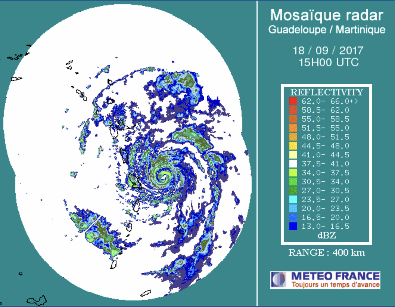
Looks like concentric eyewalls may be forming on the Martinique radar. Hoping this can thread the needle between Martinique and Dominica...

-
Shear associated with the upper trough to the system's west.