Jonbo
-
Posts
586 -
Joined
-
Last visited
Content Type
Profiles
Blogs
Forums
American Weather
Media Demo
Store
Gallery
Everything posted by Jonbo
-
Report finalized and no major changes to the preliminary ratings. Rotation that went right over my place before touchdown confirmed EF0. I'm ok with that
-
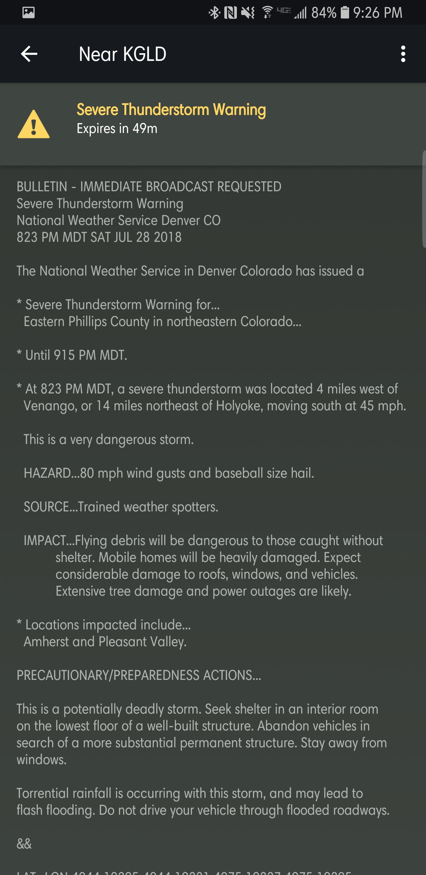
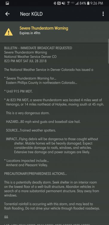
Yikes. Spotter confirmed 80mph gusts and baseballs.
-
2" hail and 70mph gusts (nws estimate) bearing head on for Oshkosh, NE edit: New warning 3" hail and 70mph gusts. Very dangerous storm wording added. That cell is going insane edit2: Now 80mph gusts and baseball size hail. Lordy
-
Still preliminary but should be updated sometime soon here. https://www.weather.gov/dmx/20180719_Tornadoes Appears my video of the rotation going overhead was moments before the report ENE of Ankeny, forwarded it to DMX. Didn't think it was going to drop that quickly or I would've followed it sooner. Pella got extremely lucky, EF2-3 damage would've been over practically all of town if it the track was only 1-2 miles back to the west.
-
I noticed this while initially chasing it. When it was by Bondurant, I had to detour and saw a lot of areas rotating looking north on the backside. Wonder if my phone caught them. Nerve wracking day for me regardless. Rotation on the Bondurant storm blew up literally over my place (video here) Absurd video someone took from the same road my dad uses to get to work. https://m.facebook.com/story.php?story_fbid=734468023559973&id=100009903462169 My video of the other Bondurant tornado hitting a farm. Further back from the much closer one posted. https://mobile.twitter.com/JonBothe/status/1020042249336500226 Edit: Marshalltown and Pella tornadoes rated preliminary EF3, Bondurant low EF2 but mostly EF0-1.
-
Thanks. I was considering following it but headache combined with adrenaline rush was too much to do more than the Bondurant one. My dad was still at work in Marshalltown when it hit. Barely grazed work but he was on the edge and heard the freight train.
-
Preliminary low EF2 on the second Bondurant tornado (the one that clipped town). Preliminary EF3 on the Marshalltown and Pella tornadoes.
-
I think this was a case of models and obs showed some uncertainty until the last minute. Thankfully NWS DMX stayed on top of things when it rapidly escalated... I certainly wasn't prepared to chase with 2% probs until it was a mile east of home.
-
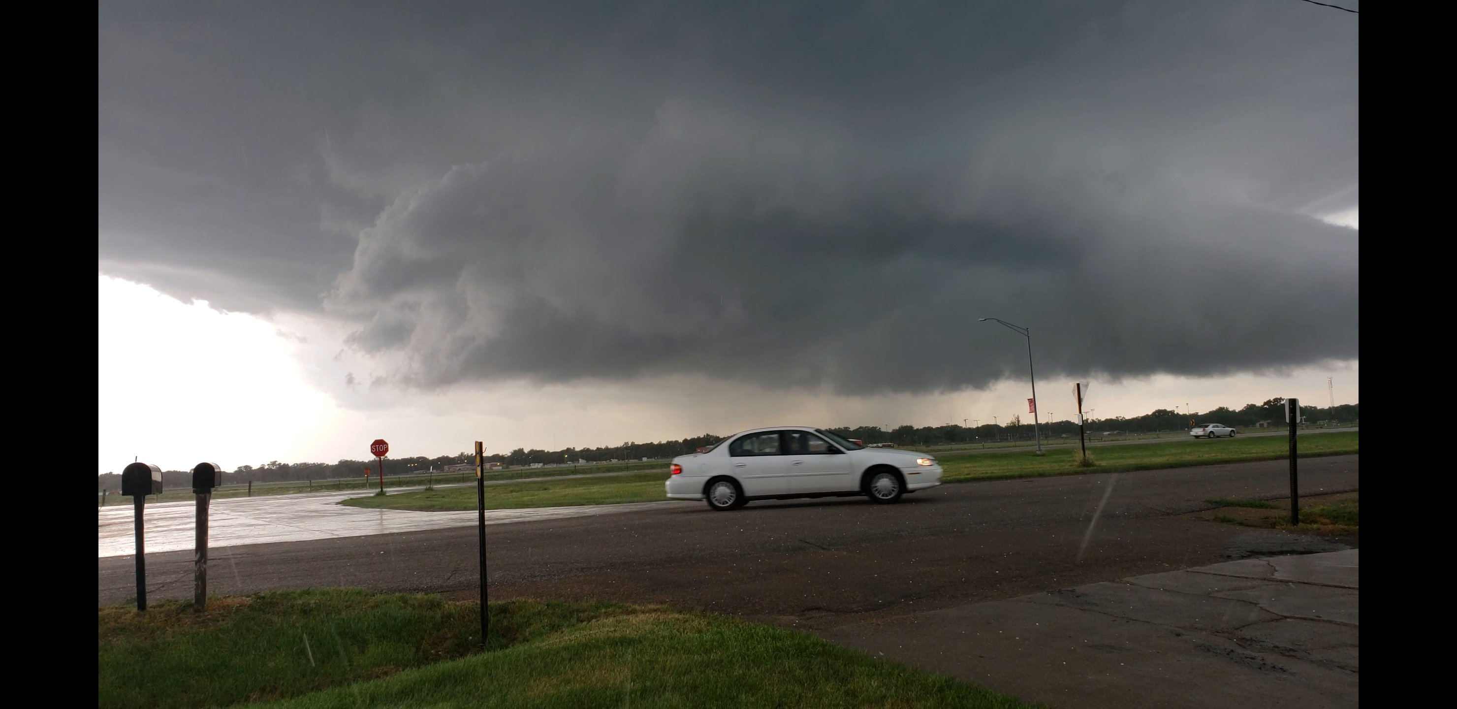
Saw one of them, picture from video capture. Even managed to capture it on video about 15 minutes prior when it was rotating high up pretty strong over my place.
-
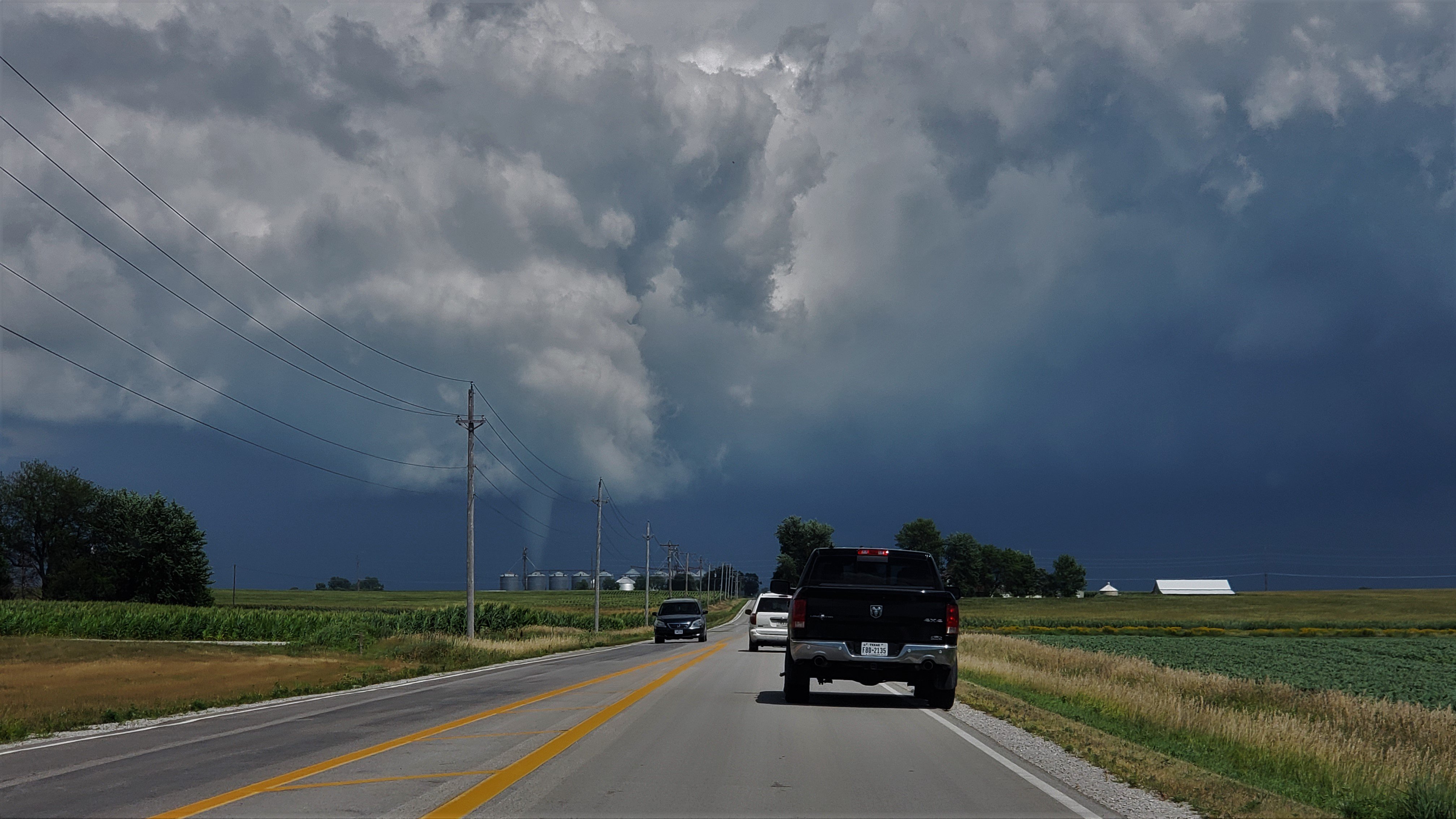
Crazy day in Iowa with multiple tornadoes on the ground, tornado emergency for Marshalltown and a tornado no more than a mile or 2 from my parents place. Saw some of it from the backside with debris. https://www.facebook.com/tj.phillips.71/videos/10155841304052736/ edit: Catastrophic damage reported in Marshalltown.
-
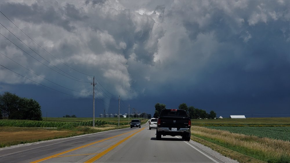
Agreed. I've chased so many storms that had incredible wall clouds spinning but nothing would come down or all the way down. Every. Single. Time. Pictures come out great but it's frustrating still. Amazes me models get consistent on something big or a big day and poof, little to nothing.
-
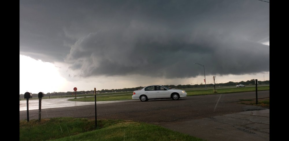
Fremont storm I was watching was ready to be mean and thankfully failed, would've devastated Fremont. The Louisville short lived wedge kinda reminded me of El Reno and even Fremont storm. Huge low scraping wall clouds but not a comparatively extreme tornado within it due to the downgrade from ef5 to ef3. Wonder how similar atmosphere yesterday around Omaha looked before El Reno. Some difference was there
-
Central/Western Medium-Long Range Discussion
Jonbo replied to andyhb's topic in Central/Western States
GFS going a bit bonkers.
-
MO/KS/AR/OK 2019-2020 Winter Wonderland Discussion
Jonbo replied to JoMo's topic in Central/Western States
How about that Marginal severe weather risk for Monday? Winter won't take over without a fight i guess. -
EF-2 tornado hit Tulsa very early this morning. http://ktul.com/news/local/nws-confirms-tornado-in-midtown
-
Wild hail storm here earlier. Baseball and near softball size in Omaha from pictures on social media. Core went just north of me but I had a lot of ping pong to golf ball size fall for 5+ minutes. These had already melted a fair amount from the rain before I could safely go out and grab some to freeze.
-
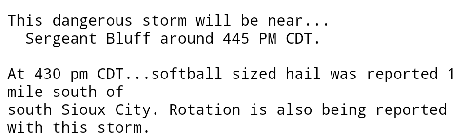
Softball size hail reported south Sioux City, IA. Warnings currently for baseball size and 60mph gusts.
-
I'm rushing to get my phone factory reset and hope it fixes problems taking pictures (my only camera for the moment) and other things. Seems I won't have to go very far if today pans out as expected around here.
-
There was an incredible hail storm in Hinton, IA on Saturday. Warning, you may want to lower your volume before hitting play. It is extremely loud
-
This is a radar image to keep for being Christmas day in Nebraska. Some spots are severe warned at times but still an amazing sight for this time of the year. Giphy compressed it hard, unfortunately.
-
This evening was much more exciting than I expected. Rope tornado/waterspout on Lake Manawa just a few miles away from where I live currently (Council Bluffs) so I bolted out and got to watch what I'm considering my first in-person tornado. People who live near the lake also mention fish being found in their yards, unsurprisingly. Pics from the driveway before I left and recorded the rest on video. Few videos also from Facebook https://www.facebook.com/wowt6news/videos/10154351752682086/ https://www.facebook.com/kenny.neelon/videos/10154509112459430/ https://www.facebook.com/leopoldo.willox/videos/10210163062983199/
-
MD for essentially 3 counties? That seems unusual
-
OFB's galore around/west of Omaha. Interested to see if this impacts the anticipated severe weather tomorrow.
-
Fairly rare October tornado today in NW IA near Hospers. Took on a wedge shape at one point.
-
Storm just east of Omaha looks the best chance at some semi discrete cell action and it's in a prime spot.