OHweather
-
Posts
4,887 -
Joined
-
Last visited
Content Type
Profiles
Blogs
Forums
American Weather
Media Demo
Store
Gallery
Everything posted by OHweather
-
Looking at the 12z NAM and recent RAP runs, they now bring the winds around to a solid WNW direction tonight. Granted, moisture depth and inversion heights are very marginal. The 0z ARW and NMM again spit out a quarter to half inch of QPF under any banding across the Snowbelt, but that may be a bit high. There could be an ok burst this evening with the wrap around snow showers that drops up to an inch, and then we see where any bands set up. I could see locations like 422 doing OK if the latest NAM and RAP are right about the winds. Moisture depth and inversion heights are pretty marginal (inversions around 7k feet and moisture up to 4-5k feet) so you'd have to get under a band for a little while to see more than an inch or two.
-
I'd imagine they got enough rain and will see enough wind to disperse the ice starting to form, although a warmer push of air would've been nice there too.
-
Looking at their forecast graphics, they have temps quickly rising into the lower 50's tonight, but have lower 40's right about now (which is several degrees too cool) which is where that low comes from. Cincinnati is pushing 60, so I wonder if we can get like 57 or 58 as a pre-dawn high tomorrow.
-
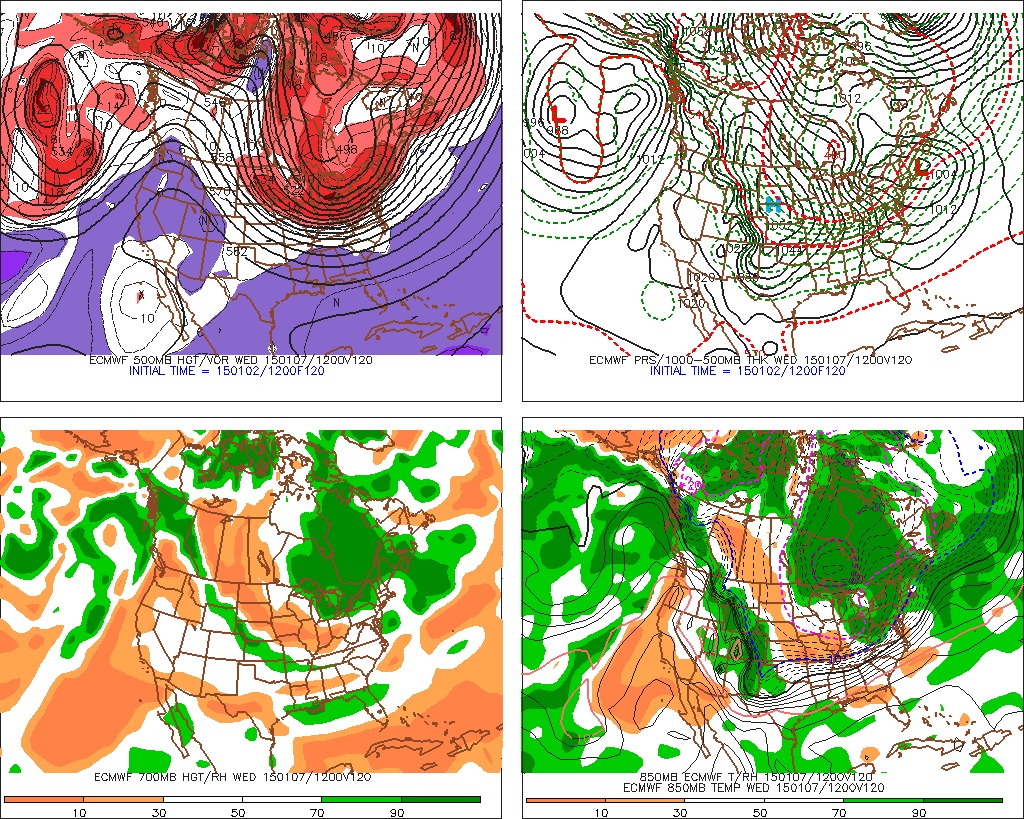
It looks like tomorrow evening the remaining deform snow moves through. It won't be much, but some lake enhancement should occur in a WNW flow as the deform moves through so I think most of us in the Snowbelt will get an inch or two tomorrow evening. Later tomorrow night pure LES takes over. The parameters are similar to Tuesday night. There might be a little more instability, but moisture depth and inversion heights are similar. The NAM shows just a slightly north of due west wind which would keep things probably north of 322 up towards Chardon, while the GFS would be WNW enough to get the better snow as far SW as the 480 corridor out into Solon and probably even where I am. The Euro is in between. Regardless, it looks like a mainly light "event" Sunday night into Monday...1-2" from the deform/lake enhancement Sunday evening, and then another 1-3" wherever the lake effect sets up. The GFS brought the clipper back north a little bit, with the 0z Euro and 12z GFS both showing .2-.3" of QPF across northern Ohio. Ratios will be decent with the clipper, probably close to 20:1. That does imply a 4-6" snowfall, however the snow will be quick hitting and omega looks modest in the DGZ, so I'm thinking more of a 2-4" with the clipper. Behind the clipper the flow looks WNW with increasing moisture and instability Tuesday night, with the GFS and Euro both showing a surface trough dropping across the lake Wednesday morning. This may support a primary single band from northern Lorain and Cuyahoga points east that drops south on Wednesday, with a multi-band setup taking hold in a NW flow by Wednesday afternoon. The instability and equilibrium heights progged by the GFS are more impressive than any of the November events for Wednesday and Wednesday night with impressive moisture depth to over 10k feet. My one concern is the GFS shows very dry dew points at CLE which may hurt us with a NW flow, however the GFS is going to under-do heat and moisture flux off of the Great Lakes, so I imagine that as the NAM gets in range it will look better with the low level moisture. If we get into range and the NAM does show higher dew points, I'd imagine that the eye-popping parameters and also conditioning from Lake Michigan would allow decent snows to continue in the NW flow Wednesday afternoon into Wednesday night. It will be cold enough by Wednesdy afternoon to stunt snow growth somewhat, so ratios might be held to 15-20:1 outside of any intense bands. The winds start going west on Thursday and eventually southwest by Thursday evening which should push the lake effect up the eastern lakeshore. So, it looks like a little snow Sunday evening through Monday...a general light snow with the clipper on Tuesday...a very good setup for lake effect Wednesday...with the lake effect winding down Thursday. Sounds fun to me at least...
-
This would be ideal...very cold WNW flow with deep synoptic moisture, with us still in a cyclonic flow. I will forgive the last few weeks if something like this pans out.
-
Just glancing on my phone, the GFS and Euro appear to get cold enough for some lake enhanced by Sunday evening with a NW flow too before true LES starts on Monday.
-
Yeah, it would be nice to be rewarded for our mild December by a January LES event. The lake will probably start to freeze next week. The GFS, Euro and Canadian all agree on how cold it will be more or less but differ on the clipper and how much moisture will be around. If we keep a more WNW flow we'd be able to get away with a drier airmass due to a longer fetch. As always, lots of details to work out, but a deep trough with very cold air sitting just to our north for days is a good look for decent LES.
-
The 12z Euro would be a long duration W-NW flow event starting Monday through Thursday with a clipper thrown in Tuesday. The airmass is bitterly cold with 850mb temps below -20C except for Tuesday when the clipper goes by. As long as there's some moisture which there should be with any little shortwaves that go by it'd be a great setup. The rain this weekend should ensure the western basin is open.
-
I saw that, but every model appears to show NW at some point, maybe SW for brief periods ahead of any clippers. Euro was especially fun looking in terms of possible lake effect.
-
Evidently, you can now download radar data from COD's website, save it, and upload it elsewhere. Pretty cool! Anyways, you can see the issue with last night's lake effect. The winds never stopped shifting, so the bands kept moving. Rates weren't heavy enough to add up to much without a steady-state band. Cloud tops actually got to 6-8k feet at CLE through the night so they got right up to the inversion height, but limited moisture depth couldn't be overcome due to the shifting winds.
-
It looks like the Chardon cam shows maybe 3" on the ground. Looking at the long radar loop on COD's website, the bands just took too long to get their act together last night. It looks like northern Geauga, parts of Lake and Ashtabula will end up with around 3" give or take due to a brief period of decent snows this morning, but probably not quite as much as I thought. Got 0.2" here. All three models get really cold by the middle of next week at the latest. With the PV sitting just to our north and Lake Erie not frozen, this could be our best opportunity yet. It has almost a week to change though so I'll reserve my excitement until we get to the weekend at least.
-
There's been an uptick along 422 in the last hour and the "band" extends back to the western basin. I'd expect the band to shift north some and intensify as well as the diurnal snow showers inland weaken and convergence increases along the shoreline as the winds back a little bit later this evening.
-
Drove through a half decent burst in Solon. The flakes were big and fluffy, if a band does set up later it won't be hard to rack up a few inches with that snow growth. Most of the BUF WRFs do show a band tonight although with mainly light snow. The NMM and ARW both show a quarter to half inch of liquid from NE Cuyahoga east through northern Geauga and the rest of the Snowbelt. So I feel the parameters and hi-res models support a 2-5" snow if a band forms. I feel like some kind of band will form tonight, although with only a small northerly component to the wind it might get stuck along the 322 corridor, which is just a bit too far north for most of us. I'm not expecting much here but our Chagrin and South Russel posters may be in the game, but it'll be close for them.
-
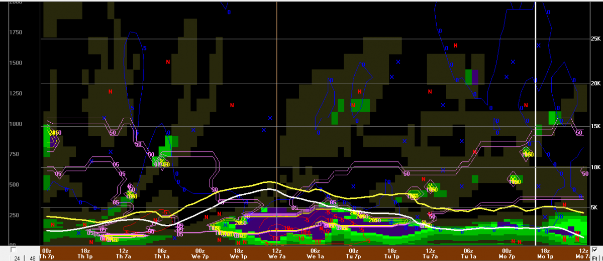
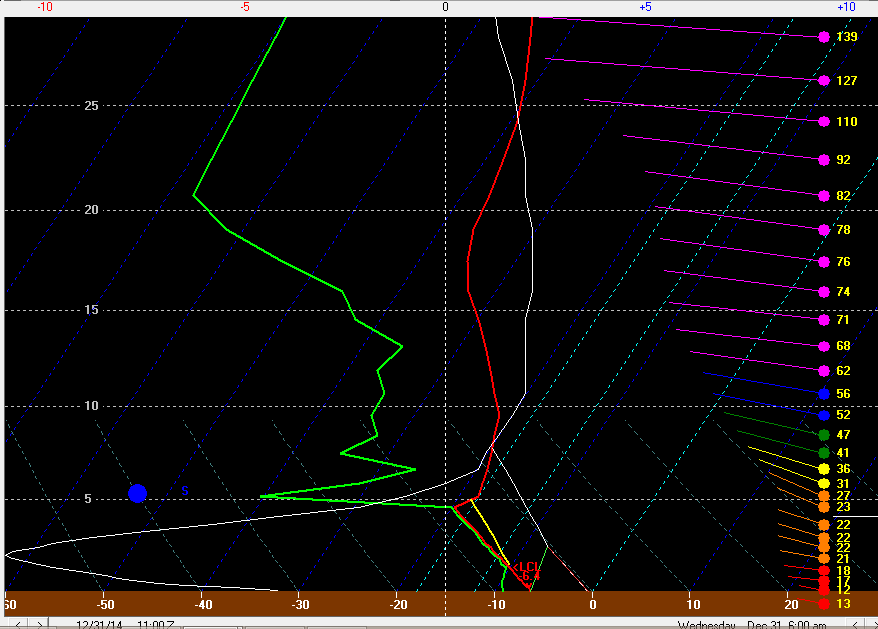
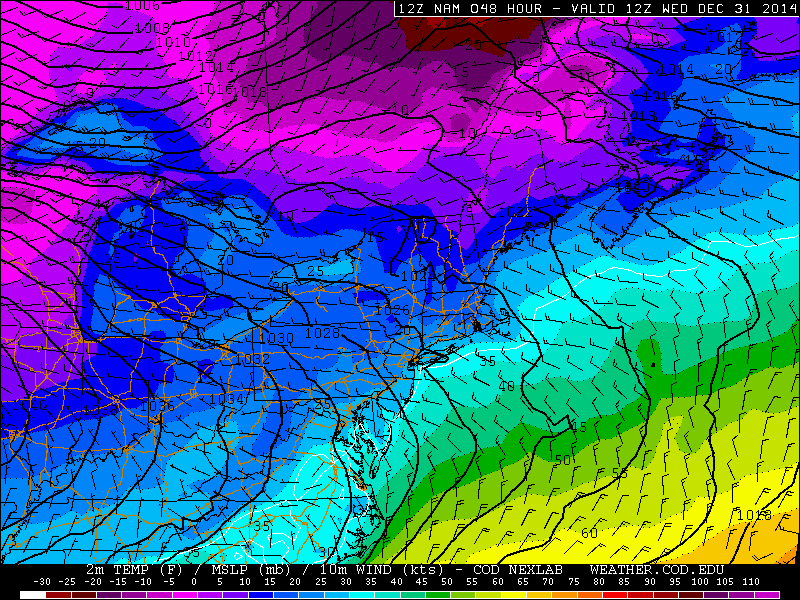
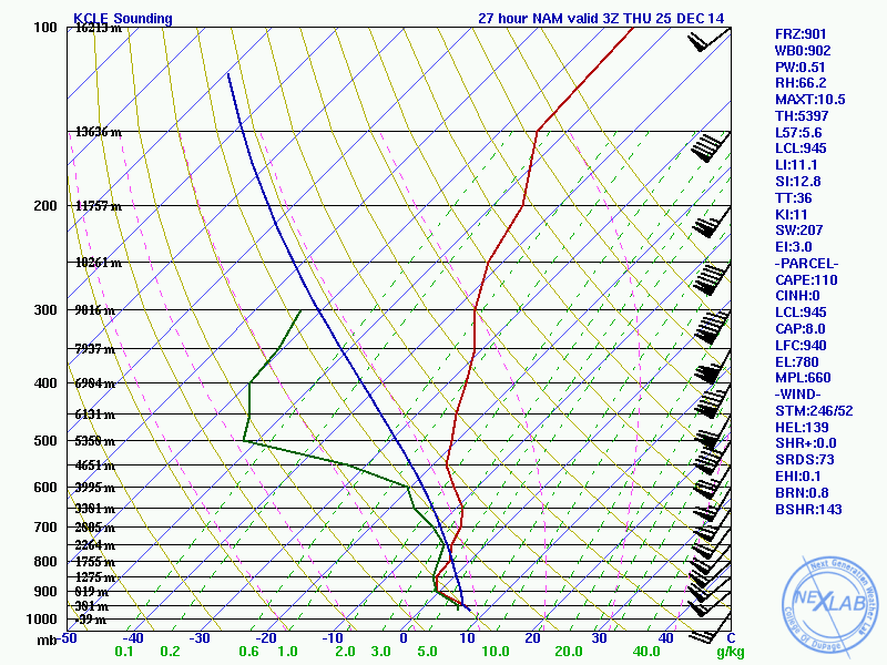
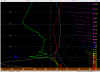
It looks like some lake effect will finally occur here over the next couple of days. It may affect Cleveland's currently 3rd least snowy December depending on where any banding sets up. A weak shortwave will move through northern Ohio tomorrow morning, with some increase in mid-level moisture. Instability will be pretty marginal, with lake to 850mb temp differentials tomorrow of 15-17C (increasing towards evening) and equilibrium levels of 6-7k feet, however, forecast soundings do show moisture below the EL so I do think there should be just enough moisture and instability for light snow showers tomorrow. With a short fetch with NW winds and such marginal conditions I don't expect more than an inch through tomorrow afternoon, but it will be nice to see a few flakes around (I saw a couple of snow grains yesterday, but that's about it) For tomorrow night conditions get more interesting, and a band could setup and produce plowable amounts of snow for some of us. Mid-level temps will cool several degrees with lake to 850mb temp differentials of around -20C tomorrow night into early Wednesday. The NAM shows equilibrium levels rising to around 7k feet or a bit better tomorrow night into Wednesday morning, with good moisture to about 6k feet. The NAM in BUFKIT gives 300-500 J/KB of lake induced CAPE for CLE, which is moderate. The winds will be well aligned from the WNW tomorrow night into Wednesday morning before going more SW by noon Wednesday. The lake effect parameters support moderate snow rates, with a good portion of lake induced CAPE on the BUFKIT forecast soundings lying in the dendrite growth zone, which may promote the more common fluffy LES ratios we're used to. Surface high pressure will be building in from the SW with colder air temps inland which tends to support convergence near the lakeshore, and the NAM does appear to show a lake aggrigate trough downwind of both lakes MI and Erie which may also help support convergence along the central lakeshore tomorrow night. Given the potential for moderate snow under any banding tomorrow night with good ratios, and what appears to be some potential for a band to set up for several hours from northern Lorain County east through a good chunk of Cuyahoga and into Geauga, I could see a 2-4" or if a persistent band sets up possibly up to 5" snow event. This is way more than any outlets are mentioning at this time, but I believe the parameters support this potential, especially if a band can setup for several hours tomorrow night. If there's no band we'd probably see more of a 1-3" type scenario play out. The 12z NMM and ARW both did produce over a quarter inch of QPF across parts of Cuyahoga and Geauga Counties through 7AM Wednesday with a band still continuing at the end of the run, so there is some model support for this idea. "BUFKIT graph" for CLE using the NAM. The yellow line is equilibrium level, the white line is lake induced CAPE (CAPE values are on the left). The purple and yellow outlined area represent the snow growth zone. Note how good lift (the red contours) and moisture do get into the snow growth zone tomorrow night, which coincides with half decent lake induced CAPE and EL's: A more traditional skew-t off of BUFKIT for 6AM Wednesday: You can see the NAM trying to show some convergence near the lakeshore in the wind barbs, and also note the modest kink in the isobars near the southern lakeshore of Lake Erie and also just downwind of Lake MI at 7AM Wednesday:
-
Hopefully everyone had a nice Christmas. Didn't realize quite how bad this December has been historically.
-
The winds are underperforming by a good 10-15MPH, likely due to the low ending up several MB weaker and a good bit east of where it was modeled last night. A severe thunderstorm warning was issued for Cuyahoga and CLE gusted to 54MPH with the line. I was in Solon and saw a whopping one flash of lightning and gusts probably close to 50 with the line. Behind the line, the peak gusts with the synoptic winds were generally 40-50MPH looking through METARs from this evening, but are already essentially subsiding below advisory criteria. The squall line was kind of cool but overall not as exciting as I was expecting, which is probably a good thing with it being Christmas Eve. Hopefully we can at least get some decorative flurries Christmas morning.
-
Very turbulant Christmas Eve coming up for the area. I still think that the CLE record high of 65 will be in some jeopardy if we can get a little sun during the afternoon which is possible, although we may ultimately fall a bit short. There will be the potential for a squall line of low topped convection to develop along the cold front during the late afternoon in SW Ohio and move through Cleveland around 7PM give or take. Models spit out a little bit of CAPE although the squall line would be driven by forcing with the cold front. There will be a deep layer of 50-60 knot winds just above the ground when the front moves through, and I think models may be underdoing surface temps by a few degrees ahead of the front, which would add a smidgen more instability. It won't be hard for convective showers/possibly storms to bring down wind gusts in excess of 60MPH. The SPC day 2 outlook had most of Ohio outlined in a "marginal risk", and I think an upgrade to the old school slight risk may be in order in following day 1 outlooks if a squall line looks to develop. The 3z RAP appears to show enough low level turning for perhaps some spin-up tornadoes through late afternoon if a squall line can develop in western Ohio. I am impressed with the synoptic wind potential behind the front in western Ohio and also for areas within 20-30 miles or so of Lake Erie. Looking at soundings from the 0z GFS and NAM, both models show pretty good mixing to about 850mb where there will be 60-65 knot winds during the evening hours. In addition, strong cold air advection (sinking air) and good pressure rises (about 2mb an hour for a time during the evening) also support strong winds. I think the potential exists for several hours of gusts into the 50's behind the front with some of the highest gusts possibly pushing 65MPH for brief periods of time. I'd expect CLE to upgrade their current high wind watch to a warning, and issue either an advisory or perhaps warning for the rest of their CWA at some point. I think the synoptic winds behind the front have the potential to cause more issues for more people, although it would be "cool" to see severe thunderstorm warnings on Christmas Eve, so we'll see if the severe threat along the front can pan out too. Next week, the GFS and Euro both suggest cold enough air for good LES for the first time in nearly a month with W to NW winds. There may also be some risk for synoptic snow Sunday or Monday due to a wave of low pressure riding to our south. With a strong ridge developing over western North America all the way into Alaska this weekend into next week with the polar vortex finally becoming entrenched over Canada, this cold shot may not be a mirage, but still time for things to change on the models. I'll weenie out about all the wind first before worrying about the snow, lol
-
You are correct. I'd almost be surprised if CLE doesn't crack 60 for at least a few hours on Wednesday. I believe the record is 65 which might be doable if we get some sun like some models are suggesting.
-
CLE ended up issuing a winter weather advisory for the freezing drizzle...I heard it got pretty bad on some of the highways and parts of 480 were closed for a time. There was definitely freezing drizzle out here for a few hours but everything was pretty well treated. There's a half decent W-E band slowly sagging south across the metro right now, but the snow is pretty sand like so it's not accumulating efficiently. Encouraging trends on the 0z model runs for wraparound snow potential on Christmas Eve into Christmas day but that has a long ways to go.
-
It's been snowing very lightly essentially non-stop for a little over 24 hours here now...have racked up a whopping 0.2" in that timeframe.
-
Looks like we'll get a couple days of light lake effect snow showers starting tomorrow and possibly extending into Friday. Instability is weak and inversions don't get much above 850mb, although there is good moisture beneath the inversion, so we will probably whiten the ground in the Snowbelt by Friday but not much more. I'm somewhat worried about freezing drizzle at times with the moisture/instability not getting above the -10C isotherm on the soundings for a good portion of the "event." We'll see what next week brings. Even if the synoptic storm on the models misses us, it should get colder for some better lake effect on the backside depending on the wind direction.
-
We should have synoptic storms to track over the last 10 days of the month, whether they actually hit us with snow vs miss to the east or cut too far to the west remain to be seen. The GFS and Euro ensembles are showing a chilly look after Christmas, so we'll see if that can get the LES machine cranking. I'm hoping for an active next 4 weeks either way.
-
Devastating tornado strikes Joplin, Missouri
OHweather replied to Hoosier's topic in Weather Forecasting and Discussion
Actually, based on the image Cyclone posted, they were in fact lucky, with houses leveled immediately to their NW. This is a dumb arguement, Cyclone did a lot of work trying to find where these videos were shot which as a reader is extremely helpful. He was also correct that the tornado bending ESE before lifting caused it to track over the house that particular video was filmed at. He was also correct in stating that if they were not hit by the tornado when it was in its weakening stages that their house may have suffered much more damage, and that perhaps they could have been injured/killed. Based on the image Cyclone has already posted, the tornado was without a doubt weakening when it struck their location: Edit: Evidently I'm wrong.
-
Devastating tornado strikes Joplin, Missouri
OHweather replied to Hoosier's topic in Weather Forecasting and Discussion
Cyclone is correct in that the tornado was weakening rather quickly at the location that particular video was filmed at, it had already weakened from an EF-5 to EF-4 and was well on its way to an EF-2 at the time. Either way the tornado was done doing its worst damage. That does make a big difference which is why they were "lucky" the tornado hit them while it was weakening and on its way to lifting.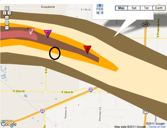
-
Historic Tornado Outbreak April 27, 2011
OHweather replied to CUmet's topic in Weather Forecasting and Discussion
I have some relatives who live in Atlanta and have a weekend house up near Sky View/Dillard. Any tornado, if it was on the ground went close to their house. They'll be up there Friday and evaluate any damage at that time.