Bubbler86
-
Posts
24,809 -
Joined
-
Last visited
Content Type
Profiles
Blogs
Forums
American Weather
Media Demo
Store
Gallery
Everything posted by Bubbler86
-
My chance is arriving here shortly.
-
Graupel counts as snow from what I understand. Similar to sleet.
-
Your mid Feb no snow streak is over.
-
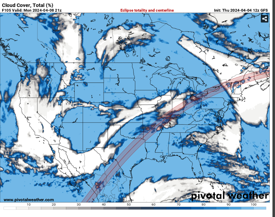
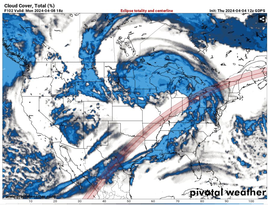
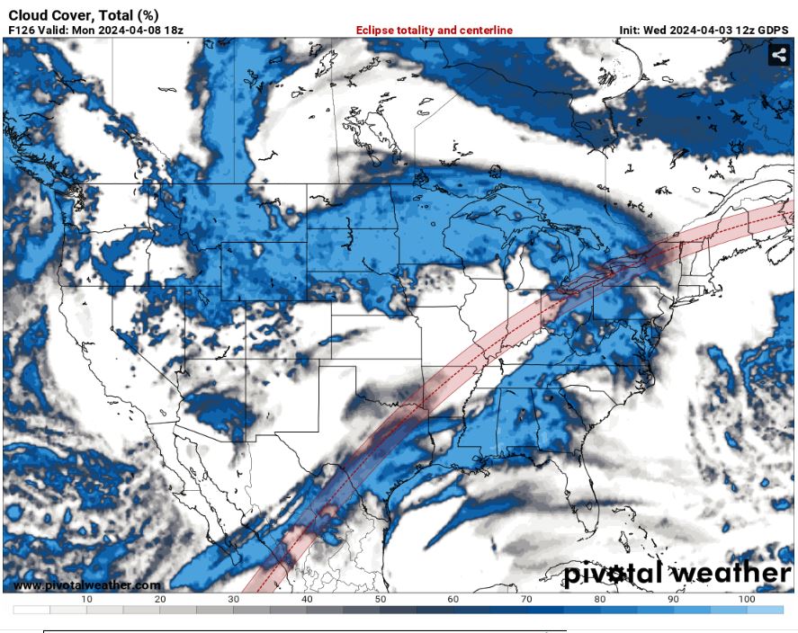
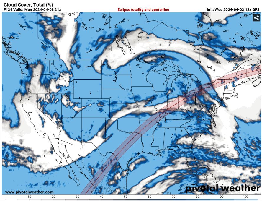
It continues to look not at all ideal for the eclipse (in our area.)
-
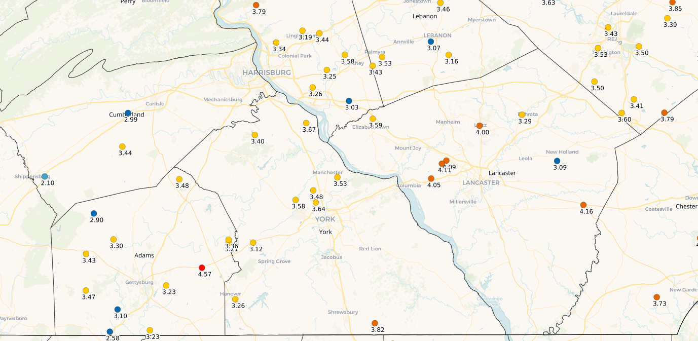
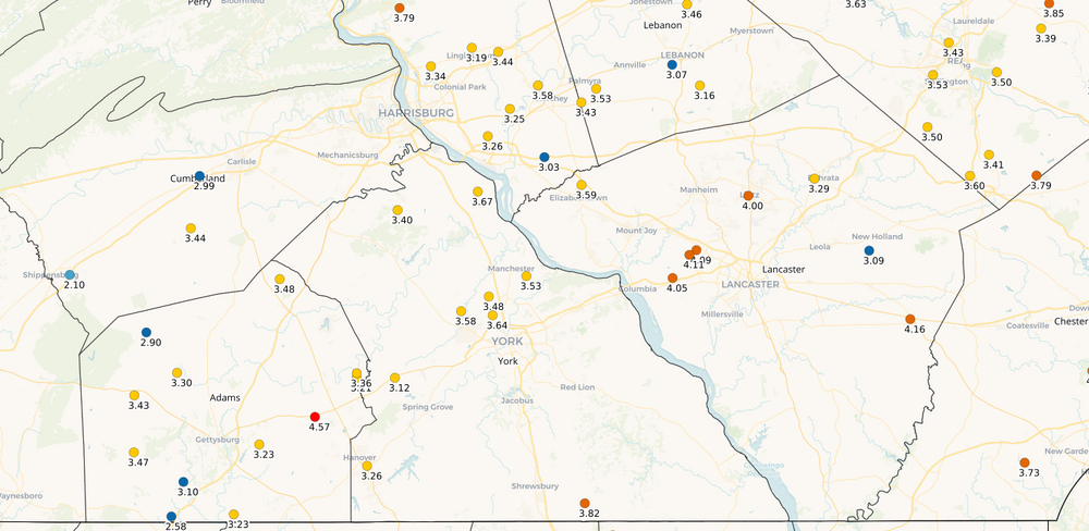
On the point of your comment toward my question, in the central and southern LSV area, every NWS total is about .5 to .75" below almost the entire suite of reported figures on here (using the closest station to each report.) It was not just your area; it was central and southern LSV wide. If you take off CXY (though their yearly total is pretty consistent with the others) I would have thought most reports would have been between 3 and 3.75" while almost all were between 3.75" and 4.5". Not often that every NWS station is below every local report. Here is the updated COCO for compare though this has a flaw if the 7AM reporting is correct as it would include 7 hours of potential rain since midnight. The gauge differences could explain it but that goes right back to questioning all measurements then. People who use manual gauges also face the issue of being there to watch live and deal with evap. LNS: 3.72----14.61 MDT: 3.23----15.37 THV: 3.11----14.11
-
NWS totals for Mon-Wed and yearly beside. Pretty much everyone is above normal on yearly precip at this point. My yearly is about 12.5 and I was fairly even with the central LSV until these last 3 days. LNS: 3.72----14.61 MDT: 3.23----15.37 THV: 3.11----14.11 CXY: 2.80----14.12 HGR: 2.09----11.45
-
33 this Am with some light roof frost. No 20's over this way though.
-
This next band is congealing nicely on the HRRR for yet more rain in the east LSV. Maybe the first snowflakes of the week over this way.
-
3" since Sat AM and 2.25" from Mon-Wed here is current total. 72 hours matched fairly well fairly with the NWS totals as of 10:30AM for a fellow observer just to my North. Minimal rain since lunchtime. Latest Public Information Statement: 000 NOUS41 KCTP 031504 PNSCTP PAZ004>006-010>012-017>019-024>028-033>037-041-042-045-046-049>053-056>059- 063>066-040304- Public Information Statement National Weather Service State College PA 1104 AM EDT Wed Apr 3 2024 ...72-HOUR PRECIPITATION REPORTS... Location Amount Time/Date Provider ...Pennsylvania... ...Adams County... Shippensburg 2.64 in 1016 AM 04/03 CWOP Biglerville 2.56 in 0730 AM 04/03 COOP ...Bedford County... Bedford Airport 2.43 in 1015 AM 04/03 AWOS 0.6 NE Blue Knob State Park 2.40 in 1000 AM 04/03 COOP 0.9 S Saxton 2.30 in 1015 AM 04/03 COOP ...Blair County... Blair Helibase 4.11 in 1016 AM 04/03 RAWS 4 NNE Williamsburg 3.95 in 1025 AM 04/03 AWS Tyrone 3.60 in 1015 AM 04/03 COOP Williamsburg 3.22 in 0715 AM 04/03 COOP 2 NNW Altoona 3.09 in 1030 AM 04/03 AWS Altoona 2.86 in 1015 AM 04/03 CWOP ...Cambria County... Johnstown Airport 4.17 in 0954 AM 04/03 ASOS EBEP1 3.15 in 1015 AM 04/03 HADS ...Centre County... Philipsburg 3.69 in 0800 AM 04/03 COOP Bear Knob 3.68 in 0949 AM 04/03 RAWS State College 3.67 in 0800 AM 04/03 COOP Stormstown 3.63 in 1015 AM 04/03 CWOP 2 SW State College 3.42 in 1015 AM 04/03 CWOP State College 3.31 in 1015 AM 04/03 CWOP Bellefonte 3.08 in 1030 AM 04/03 CWOP AccuWeather HQ 2.84 in 1015 AM 04/03 CWOP Pa Portable No. 1 2.70 in 0959 AM 04/03 RAWS Pennsylvania Furnace 2.53 in 0948 AM 04/03 CWOP Garden Hollow 2.51 in 1008 AM 04/03 RAWS ...Clearfield County... Grampian 4.31 in 0800 AM 04/03 COOP Kennedy Preserve 2.88 in 1008 AM 04/03 RAWS Dubois 2 S 2.86 in 0545 AM 04/03 COOP Clearfield Airport 2.79 in 1001 AM 04/03 ASOS ...Clinton County... Coffin Rock 2.74 in 1016 AM 04/03 RAWS ...Columbia County... Bloomsburg 2.24 in 1025 AM 04/03 CWOP Berwick 2.22 in 1030 AM 04/03 AWS BLOOMSBURG 2.10 in 1015 AM 04/03 CWOP ...Cumberland County... Carlisle 3.13 in 0700 AM 04/03 COOP Tumbling Run 3.02 in 0949 AM 04/03 RAWS Wormleysburg 2.86 in 1029 AM 04/03 AWS Pine Grove Furnace 2.80 in 0800 AM 04/03 COOP 1 SSE Carlisle 2.54 in 1030 AM 04/03 AWS 2 SSE Mechanicsburg 2.30 in 1035 AM 04/03 AWS 1 N Enola 2.24 in 1030 AM 04/03 AWS Newville 2.07 in 1030 AM 04/03 AWS ...Dauphin County... Hershey 2.91 in 1015 AM 04/03 CWOP 1 NE Hummelstown 2.86 in 1030 AM 04/03 AWS Manda Gap 2.74 in 1018 AM 04/03 RAWS Harrisburg Intl Airport 2.60 in 1032 AM 04/03 ASOS Hummelstown 2.54 in 1030 AM 04/03 AWS 1.3 N Elizabethville 2.50 in 1000 AM 04/03 COOP 1.0 NE Lemoyne 2.33 in 1000 AM 04/03 HADS Halifax 2.24 in 1015 AM 04/03 CWOP ...Franklin County... Mercersburg 2.94 in 1029 AM 04/03 AWS Willow Hill 2.88 in 1029 AM 04/03 AWS Greencastle 2.60 in 1015 AM 04/03 CWOP Mont Alto 2.57 in 1030 AM 04/03 AWS 1 NE Rouzerville 2.30 in 1030 AM 04/03 AWS ...Fulton County... Forney Trail 3.28 in 0949 AM 04/03 RAWS Mcconnellsburg 2.20 in 1000 AM 04/03 COOP Mcconnellsburg 2.00 in 1020 AM 04/03 CWOP ...Juniata County... Mifflintown 2.55 in 1029 AM 04/03 AWS Perulack 2.20 in 1015 AM 04/03 COOP ...Lancaster County... Pequea 3.03 in 1015 AM 04/03 CWOP 2 ENE Willow Street 2.78 in 1030 AM 04/03 AWS Manheim 2.68 in 1015 AM 04/03 CWOP Millersville 2.55 in 1035 AM 04/03 AWS Mount Joy 2.52 in 1015 AM 04/03 CWOP Millersville 1 S 2.47 in 0800 AM 04/03 COOP Holtwood 2.36 in 0800 AM 04/03 COOP Lancaster 2.35 in 0800 AM 04/03 COOP Abington 2.35 in 1015 AM 04/03 CWOP Safe Harbor 2.32 in 0800 AM 04/03 COOP Ephrata 2.31 in 1020 AM 04/03 CWOP 2 NW Gap 2.27 in 1030 AM 04/03 AWS Ephrata 2.26 in 1015 AM 04/03 CWOP 1 WNW Lancaster 2.25 in 1030 AM 04/03 AWS Lancaster Airport 2.19 in 1006 AM 04/03 ASOS Manheim 2.19 in 1030 AM 04/03 AWS 2.1 SE New Holland 2.08 in 1200 AM 04/03 COOP Elizabethtown 2.02 in 1030 AM 04/03 AWS Terre Hill 2.00 in 0752 AM 04/03 AWS ...Lebanon County... Cornwall 3.09 in 1030 AM 04/03 AWS Indiantown Run 2.76 in 1013 AM 04/03 RAWS Hershey 2.56 in 1015 AM 04/03 CWOP Muir Airfield Ft. Indiantown 2.21 in 0955 AM 04/03 AWOS 2 E Sand Hill 2.03 in 1030 AM 04/03 AWS ...Lycoming County... Duboistown 2.47 in 1027 AM 04/03 CWOP Williamsport Airport 2.07 in 0954 AM 04/03 ASOS Slate Run 2.00 in 1015 AM 04/03 COOP ...Mifflin County... 2 SSW Alfarata 3.87 in 1025 AM 04/03 AWS Chestnut Springs 3.84 in 0951 AM 04/03 RAWS Lewistown 3.11 in 0600 AM 04/03 COOP Lewistown 2.67 in 1030 AM 04/03 AWS Milroy 2.40 in 1000 AM 04/03 COOP ...Northumberland County... 0.6 SW Sunbury 2.40 in 0700 AM 04/03 COOP Wolf Pond 2.26 in 1008 AM 04/03 RAWS Milton 2.18 in 1030 AM 04/03 AWS Trevorton 2.14 in 1034 AM 04/03 AWS Ferndale 2.13 in 1030 AM 04/03 AWS ...Perry County... Big Knob 3.16 in 1008 AM 04/03 RAWS 2 SSE Duncannon 2.25 in 1030 AM 04/03 AWS 1.9 S Shermansdale 2.18 in 1015 AM 04/03 COOP ...Schuylkill County... Pottsville 2.84 in 1035 AM 04/03 AWS 1.9 N Hometown 2.50 in 1015 AM 04/03 COOP Bears Head 2.47 in 1008 AM 04/03 RAWS Landingville 2.41 in 0930 AM 04/03 HADS 1.4 N Mahanoy City 2.14 in 0700 AM 04/03 COOP ...Snyder County... Selinsgrove 2.49 in 0700 AM 04/03 COOP Selinsgrove 2.25 in 1007 AM 04/03 ASOS ...Somerset County... Confluence 1 SW 4.12 in 0800 AM 04/03 COOP Somerset 4.04 in 0800 AM 04/03 COOP Hidden Valley 4.04 in 0800 AM 04/03 COOP 0.9 S Somerset 3.99 in 0945 AM 04/03 HADS Somerset 3.92 in 1015 AM 04/03 CWOP Glencoe 1 E 3.87 in 0800 AM 04/03 COOP MYDP1 3.40 in 0930 AM 04/03 HADS 0.6 NW Central City 3.16 in 0945 AM 04/03 HADS Claysville 2.86 in 1015 AM 04/03 CWOP Meyersdale 2.57 in 1026 AM 04/03 CWOP JOHNSTOWN 2.30 in 1030 AM 04/03 CWOP 2.0 SW Casselman 2.08 in 0930 AM 04/03 HADS ...Tioga County... Old Mountain 2.30 in 1016 AM 04/03 RAWS ...Union County... 3 NW Penns Creek 3.09 in 1030 AM 04/03 AWS Lewisburg 2.23 in 1030 AM 04/03 AWS ...York County... 2 E Codorus 3.16 in 1025 AM 04/03 AWS York 2.89 in 1015 AM 04/03 CWOP 2 SSW York 2.61 in 1035 AM 04/03 AWS York Airport 2.58 in 1021 AM 04/03 ASOS Fawn Grove 2.56 in 1030 AM 04/03 AWS THOMASVILLE 2.29 in 1009 AM 04/03 CWOP Capitol City Airport 2.24 in 0956 AM 04/03 ASOS &&
-
Not sure the water freezes too much...would not be below freezing long based on progs. But people who have plants outside may want to think about it.
-
Could see some upper 20's tonight in the colder areas.
-
I was not sure of that, they seemed a bit low. PS @Mount Joy Snowman thoughts on why all the NWS sites are seemingly lower than almost all the readings here?
-
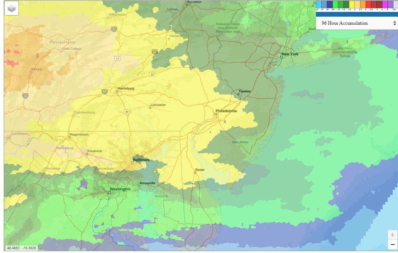
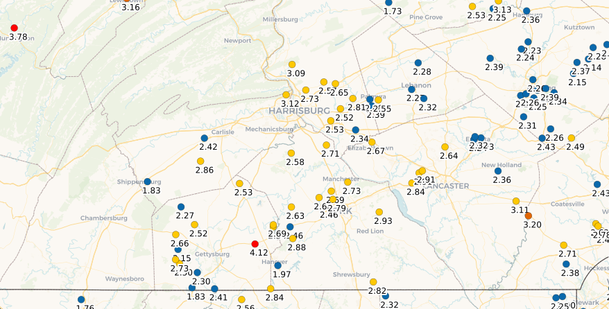
Here is Coco but unsure how up to date these maps are on the day. I know they are updated from yesterday but unsure if they are right up to the min. There is one 4 banger in there. This is April 1-3.
-
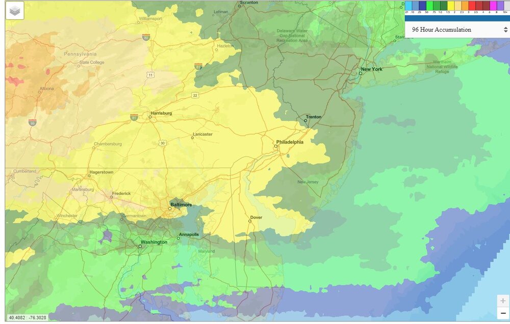
We had dropped watching this site but here is radar estimated. Lower than NWS even. I am not sure anyone cares about ups and downs of local totals as the cells can make large differences in short distances, but the NWS are the ones that will go in the record book and unless I am not seeing something right, they are basically 2.5 to 3.5" across the board for Mon-Wed. LNS is around 3.4 it seems. THV is 3.07.
-
Others have had totals similar to yours but the NWS sites are all coming in lower. The 3.04 is adding up the 5MIN obs today using the 6 hour totals and then adding the first two hours of today...and tacking that on to the official totals for Mon and Tue. CXY across the river is only at 2.7" it seems (Mon-Wed.)
-
MDT just cracked 3" for Mon-Wed at 3.04".
-
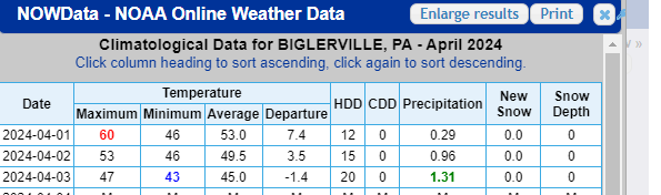
My low totals have me wondering a bit but HGR is close to matching and I just looked up this Biglerville ob with totals updated to current apparently. Similar to my totals.
-
I had 56 but not that high!
-
Yea, not much there anymore. The low coming from our SW is not packing the punch it was a few days ago on models.
-
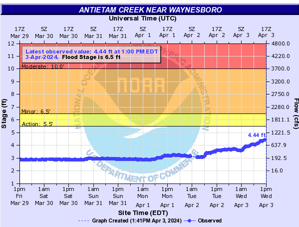
You are going to have a shot to double me and that includes Saturday as to mine Down here it has just been a normal rainy 5 days. The local creek is up 1.5 feet but still 2 feet under minor flood.
-
-
Let's get as many people watching the 90% as possible so the eye doctors can get some work in the books?
-
I think the major rains are about over for you and I (pending something tomorrow). Sun keeps coming out here. Maybe one of those renegade small cells still hits you?
-
-
Nooners. Just had a shower bringing me up to about 2" for the work week. 41 degrees.