frd
-
Posts
5,699 -
Joined
-
Last visited
Content Type
Profiles
Blogs
Forums
American Weather
Media Demo
Store
Gallery
Posts posted by frd
-
-
5 minutes ago, WxUSAF said:
Measured 3” exactly on the snowboard. Based on the radar loop, that’s not bad. Unfortunately this event gave us a half rug pull at the final hour.
Seeing reports of 14 inches in East Central PA.
-
-
29 minutes ago, psuhoffman said:
For the 6 th year in a row the weeklies sucked. LR Models can not predict HL events, nor the NAM stae, modeling can not predict the AO or the NAO far in advance. Modeling may be able to handle the warm seasons, but when cold is forecasted best to not believe it. This winter was the final straw.
-
 1
1
-
-
Crazy
BAMWx must be happy.
-
 1
1
-
-
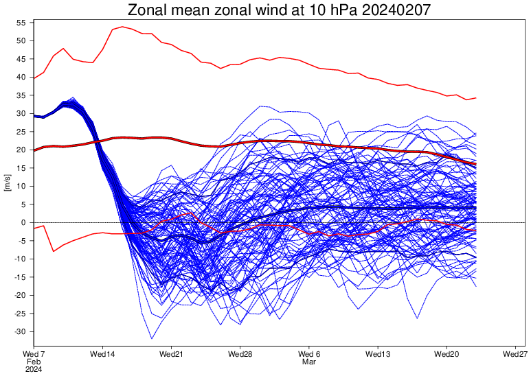
Looking at the data on Stratobserve there seems to be some changes going on mid to late month.
These changes may cause the long range ensembles to improve in the next few days to colder and snowier scenarios for our area.
Will be interesing to monitor.
-
 2
2
-
-
-
2 minutes ago, psuhoffman said:
Gfs even links the ser with the high latitude ridge again.
Been an occurrence ever since the Atlantic started to warm. The Atlantic is very warm and the Pac is warm as well.
-
31 minutes ago, MillvilleWx said:
I really like the period from the last full week of Feb through mid-March. We’ve scored in that time frame before. I think expectations for the lowlands should be tempered (I know you know lol), but the climo favored areas with elevation and/or latitude should be keen on watching what’s coming down the pike.
It would be a bummer with the end of the month pattern not to score an all snow event for my area and @CAPE . But, I get it. Even @psuhoffman mentioned some frustrations with temps. I will remain optimistic.
Hopefully things get active ( snowy ) and you can offer your valued insights.
-
 1
1
-
-
-
6 minutes ago, RedSky said:
Ugly GfS run i will pretend I never saw. Atmospheric river 2.0 hits California.
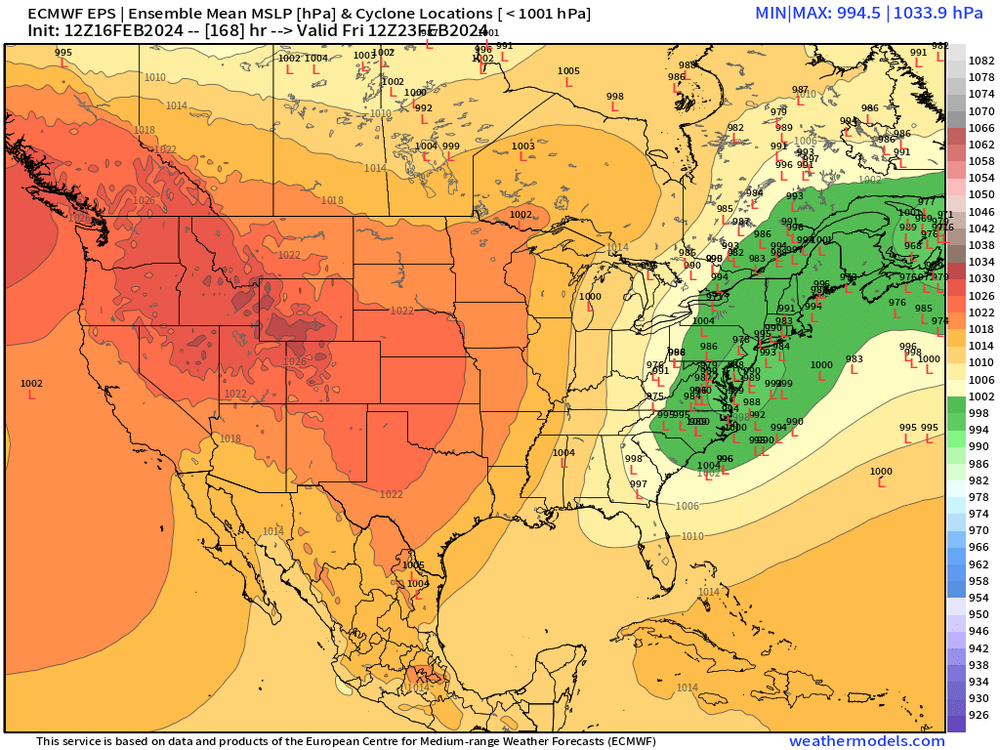
Wow, a 1057 mb High over Eastern Canada and rain here . i will call it an OP at range and its the GFS
-
 1
1
-
-
10 minutes ago, Paleocene said:
Does anybody have a link to a quick explainer for how SSW impacts things at other levels of the atmosphere? My eyes glaze over at 10mb zonal winds, but if I had any idea how this impacted the charts I do kind of understand thanks to this board (250mb, 500mb, 850mb, surface), it would really help. Thx!
https://eos.org/features/how-sudden-stratospheric-warming-affects-the-whole-atmosphere
-
 1
1
-
-
-
-
-
SOI - 39 today. Very impressive
-
 1
1
-
-
-
14 minutes ago, psuhoffman said:
That said if we do the timing of possible waves and project that we have at least until March 10 before climo starts to become a big problem, starting with Feb 14 we should have at a minimum 5 waves to track and maybe as many as 7.
You are not concerned with the anomalously displaced STJ ? You anticipate this to change later in the month?
I am thinking the massive - SOI tanking changes things up later. Just wondering .
-
-
10 minutes ago, brooklynwx99 said:
the weeklies are absolutely ridiculous. there are too many frames by themselves that are pure weenie fuel
here is just the 25th by itself
XXX Porn. Might really be the best weeklies ever, I mean ever. March might set snowfall records in the Mid Atlantic.
-
 1
1
-
 1
1
-
-
34 minutes ago, CAPE said:
^More in agreement with the signal for frozen to our north on the GEFS. With no semblance of HP up north and a marginal airmass, it all hinges on a significant piece of northern stream energy running out in front at the right time to flatten the flow/create confluence. Didn't happen this run.
When do you think is the first legit chance of a accumulating snow for the lowlands?
-
6 minutes ago, CAPE said:
Last few runs of the GEFS look less impressive in the NA compared to the EPS and GEPS towards PD. No idea what it means or if it even matters at this juncture. The overall idea across guidance is still on track.
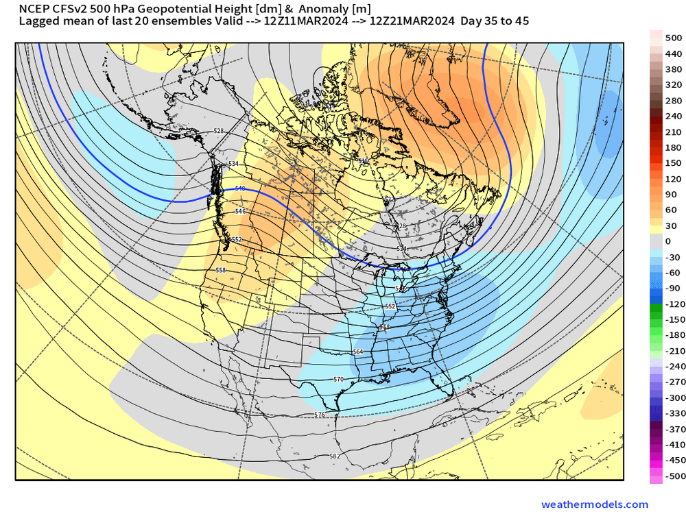
Yes, I saw that and I was reading Tip's thoughts in the New england forum where he mentioned he believes the + PNA longevity might be brief. Hard to say for sure what eventually happens in the Pac. The Greenland Block and the - AO look legit.
-
-
-


Late Feb/March Medium/Long Range Discussion
in Mid Atlantic
Posted
It's over. Really, talk about upcoming hurricane season. Atlantic Ocean is very warm already.