

EasternLI
-
Posts
3,361 -
Joined
-
Last visited
Content Type
Profiles
Blogs
Forums
American Weather
Media Demo
Store
Gallery
Posts posted by EasternLI
-
-
Then the gfs spits this out after I said that of course. Clown range here, but the interesting thing about this, the eps has a couple clusters that show something similar to this too. May be nothing, but worth a mention I think.
.thumb.png.9afeb5346861609f86b80e7bdab4ca98.png)
-
 3
3
-
-
Just starting today and going ahead, the ssw will now be included in the initial conditions on modeling. So it will be interesting to see what changes, if anything, as that becomes the case now. There's evidence available that suggests this makes a noticeable difference with predictability of how they play out. I'm not saying to expect anything crazy, just that this is a point where potential changes could occur on modeling. Or not lol.
-
3
-
-
1 hour ago, snowman19 said:
Had to drop in to agree with you on that. The Niña system is still in full effect. Also, I’m not so sure the SSWE is going to be all that effective either. This event is nothing like 2018, it’s a displacement event, adding to the uncertainty and there’s destructive interference from the +QBO and -AAM, serving to delay and convolute everything. If there’s even any tropospheric response it may not happen until the 2nd week of March. This tweet chain does a great job of explaining what’s going onYeah, I've been saying it's not really impressive looking.... The latest gfs cross sections suggest this is not making much progress downward. Best to wait until it's underway and then see what models are doing, though. But it just looks uninspiring to me so far.
.thumb.png.8526cb1265f989a3dd429a52804de14f.png)
-
5
-
-
Toss that MJO idea to the moon. Not happening. It's not going to be effective....
-
2
-
-
25 minutes ago, SnowGoose69 said:
Neutral ENSO winters which occur near the solar max historically are very bad for some reason...there has been many theories as to why...most likely its that the AO/NAO simply average strongly positive in those years but it may also be that without the La Nina/El Nino you lose some ability to get pronounced ridging or troughing in some locations so the pattern has a tendency to be more zonal and the bad AO/NAO amplify that issue
Weaker walker circulation is just not good, maybe. We want some amplitude, but too much isn't good either. It's interesting to think about.
-
2
-
-
21 minutes ago, SnowGoose69 said:
There is next to no chance its strong. I'd say there is a better chance of neutral ENSO next winter than a strong Nino
I like a weak to moderate modoki el nino next year. We're following EOF2 from the following paper fairly well. Which leads to that. I agree neutral isn't off the table just yet. Whatever it is, it is not similar to EOF1. Which leads to the east based classic events.
Leading modes of tropical Pacific subsurface ocean temperature and associations with two types of El Nino-
1
-
 1
1
-
-
2 hours ago, EastonSN+ said:
Yeah, I learned that I never want to witness a triple dip la Nina ever again.
Yes, this is usually my rule of thumb with that. It's funny too, I thought this winter would suck back in August. Then the blocking became a possibility and I reconsidered everything lol. Because blocking is what you look for in la Nina if it's going to be any good. That was an interesting development. It failed, sometimes they do. Is what it is.
1 hour ago, EastonSN+ said:Please correct me if I am mistaken but I believe the following is best enso state to worst:
Weak El Nino
Moderate El Nino
Weak la nina
Neutral
Moderate la Nina
Strong El Nino
Strong la nina
Swap neutral and moderate la nina with each other and I agree. Neutral sucks, too strong in either direction does too. Just a very basic guideline. Many other variables to consider.
-
2
-
2
-
-
It does look like the ssw is going to actually go off. Meeting the technical wind reversal definition. In addition to the eps, the GEFS is now 100% for the past few runs now. Will be interesting to see how/if it works with the troposphere following this. Be curious to see some cross sections on what is happening once this gets underway. Never can be certain with these things but worth keeping tabs on. It's something to watch at least. Hope everyone enjoys this very nice mild Friday on tap.
.png.a0f4b36ca9d9236342b2ea87dd04c1f6.png)
-
1
-
-
13 minutes ago, EastonSN+ said:
IMO getting out of this 3 year la Nina will work wonders in so many ways.
Well, it can't get much worse

I don't hate la nina. Some of them can be good. This one just has it all wrong lol. Tired of it though, I welcome a change.
-
2
-
1
-
-
4 minutes ago, EastonSN+ said:
Annnnnd of course the wave dies again in 7.
We have a legit shot at lowest historical snowfall.
Good to get it out of the way! Prolly won't see a winter this bad again in our lifetimes.

Here's a great example of why extreme caution is always needed with those charts. If we look at what is actually occurring on the model. We can see the MJO wave moving right along. However, we can also see the warm pool convection associated with la nina never fades away enough as this is occurring. This renders the whole thing less effective. This is the destructive interference we sometimes mention. We'd really want something strong enough to fully disrupt that in order for more meaningful changes. Something we just haven't seen much this year. So that forecast crashing into the COD is really trying to say it's retaining its dominance in spite of the MJO. Which is a problem for us this year. That positioning right there is the anchor for a western trough. So we end up stuck with that as much as we are. Now, let's shift that thing closer to the central Pacific next year hopefully. Then you get a western ridge instead.
.thumb.png.234b6f282dede72c10aca3503999a151.png)
-
1
-
4
-
-
Not sold yet on a technical ssw even occurring. Some warming, sure, but the gefs seems to have backed down on wind reversal today at 00z. Plus, the 06z run now only has 60% of the members on board with it. So it's still possible it doesn't even occur this time either. I realize the eps weeklies were bullish yesterday. However, I'd prefer to see total agreement. Not going the other direction. Especially as we're getting inside of day 10 now. You'd really want to see a strong event too in hopes of impacting where it matters. This is just uninspiring so far IMO. I also agree with the sentiment that even if one should occur, it doesn't necessarily have to matter for us. This is always the case and should be baked into any thinking about this topic any year.
.png.a817651b5dc7eb02eb00357b34b5fa68.png)
-
3
-
-
The purpose of the long range pattern discussions is not to identify any individual storm systems. I personally think it's a misinterpretation to think of it in that way. You can get snow events in a bad pattern. Nobody has said that can't happen. I certainly haven't. The thing is, favorable longwave patterns offer an easier path to accomplish the certain combinations of synoptic features we're all in search of. That is the reason why they are often discussed. Not to identify anything specific. At least it shouldn't be. It's simply an attempt to identify windows where it's easier to find something specific. It's really two separate things, in my view.
-
3
-
-
0F IMBY currently. That's impressive here on CAA. Usually that happens with rad cooling here. Yesterdays hrrr did alright locally here. Euro too.
-
2
-
-
-1F at the Southold mesonet.
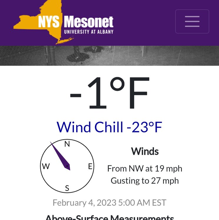
-
1
-
-
9 minutes ago, LongBeachSurfFreak said:
That’s epic! Computer or influenced?
Found it just like that on the 12z eps today
-
1
-
-
Some fitting symbolism there. Good job e20...
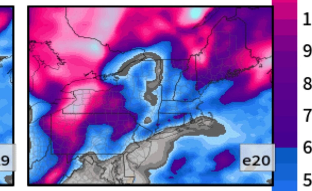
-
1
-
 4
4
-
-
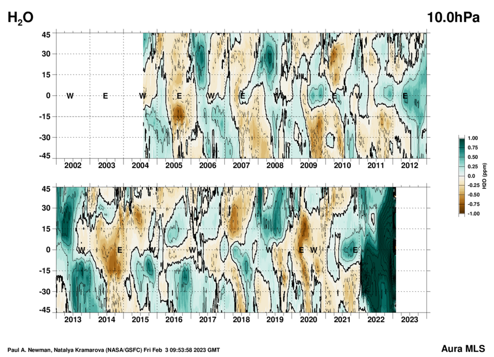
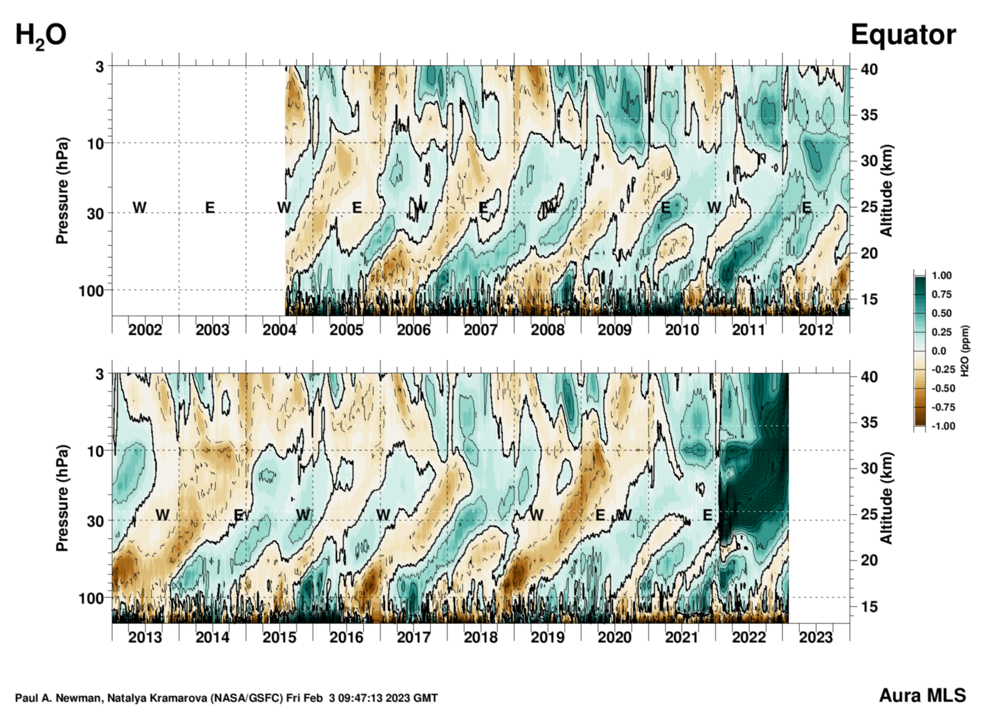
Speaking of the water vapor from the volcano. The nasa site is nice for checking on that. Looks like it has spread into the NH. While working it's way higher in altitude slowly. Looks like that is still continuing also. I have no idea what occurs due to this? It's clearly much larger than anything else on those charts.
https://acd-ext.gsfc.nasa.gov/Data_services/met/qbo/qbo.html#merrau

-
2
-
-
1 hour ago, 40/70 Benchmark said:
I don't really care, at this point. It's too late for any changes to matter, anyway.
There is actually something interesting about those conditions. Not for this season, but next year. Perhaps quite interesting, but that's TBD. I was curious about the state of the Pacific. So I re-read the following paper over the weekend. Then decided to check the state of affairs. If you look at the status of the sub surface. Plus, the forecast 850 winds. It was a little surprising to me, to discover it's a pretty damn good match to EOF2 from this paper. EOF2 is one of the leading modes of modoki el nino. EOF1 would be the classic east based variety. It's nothing like that one so far. Found that to be pretty interesting. Thought perhaps you would too.
Leading modes of tropical Pacific subsurface ocean temperature and associations with two types of El Niño
-
3
-
-
Woodchuck is just another name for groundhog. I like groundchuck though lol
-
1
-
-
26 minutes ago, Volcanic Winter said:
I know the time to surface expression of a SSW varies, but assuming it happens as some models depict, when is its impact likely to be felt?
Would really be a shame to have it for mid March and beyond, but of course that keeps the trend of luck falling the wrong way this year.
And yes, no guarantee it even happens just like the previous failed attempt.
It's still something that's really being figured out in the research sector. General idea currently is that the stronger it is the faster it would happen. But it's variable and sometimes there are no surface effects at all. Other times, it happens very quickly. This a topic that is still being studied. Only recently has a slightly better understanding of this begun to take shape. As far as I'm aware.
-
Worth mentioning that the strat is still trending. With 61% of gefs members on the 00z now having a ssw. Which is higher than I ever saw at any point during this last attempt. Just an observation this morning.
.png.cd2cae1b477361456ae32d21ad7f2d16.png)
-
1
-
1
-
-
8 minutes ago, brooklynwx99 said:
the reason why Ninas usually suck here is because there is constructive interference with the MJO in phases 4, 5, and 6, which is why it always ends up getting warm in those phases. there is destructive interference in the "good phases" of Zones 7, 8, and 1, which is why the waves almost always collapse before they make it there, and they usually don't do much if they do
we just can't expect much from Ninas here. they almost always lead to ridging, and it takes anomalous -NAO blocking to beat it down, as seen in 2010-11 and this December... unfortunately, we couldn't cash in this year
Ninos are great because there is actually constructive interference in those "good phases" due to tropical forcing that's farther east... this ties into the Aleutian Low that's normally featured in Nino winters. this leads to cold usually getting dumped into the Plains and E US instead of the Rockies
we should see a change once we get a solid Nino, which has a good shot of happening next year, definitely the one after
Pretty much, yeah. That's a good way to explain it. I'd just add, the reason why la nina is often better in early winter. Is because la nina phases can be ok in early winter. Because wavelengths are different. But later winter, forget about it. I'm interested about next year. QBOE is on deck also.
-
1
-
-
8 minutes ago, vegan_edible said:
do you think there is there a chance of some type of quad la nina next year? sounds like hell
That is extremely unlikely. Enso neutral is still a possibility. El nino is favored. However we just can't be certain of anything just yet. Easily get burned at this time of year making assumptions with enso. That much I'm certain of.
-
1
-
-
1 minute ago, LibertyBell said:
What causes the barrier?
I'd have to read up on that. I have a hunch but I'm not sure. I'm not even sure if that's known. I'm going to look into this.
-
1
-
.png.9d3ffbf529ae480ceef5a9936e5b2e60.png)
.png.25c1381ea0daf37cf611d94415c83fbd.png)
.png.111b687e503f4719d3c833d2f0002904.png)


February 2023
in New York City Metro
Posted
Yeah, 65 here too. It feels glorious, ngl.