

KokomoWX
-
Posts
1,546 -
Joined
-
Last visited
Content Type
Profiles
Blogs
Forums
American Weather
Media Demo
Store
Gallery
Posts posted by KokomoWX
-
-
6 hours ago, frostfern said:
Is anyone planning on chasing? There is a cap bust risk with this kind of setup.
Reed Timmer is bring the Dominator 3 to chase. Every time he has come to Northern Indiana, we bust hard.

-
 1
1
-
-
Yesterday was a surprise over performing system. Widespread 4-6" reports. Half of my seasonal snowfall came yesterday. Spring returns quickly with near 60 by mid week.
-
 1
1
-
-
Today has been an unexpected over performer for Kokomo and south. I really was not expecting anything beyond a heavy dusting on grass with the pavement being wet. We have 2-3" and it was falling pretty good around 10-11:30. My work (school) called for an early dismissal. Sadly project will for me to stay all day or possible even late. The forecast calls for near 60 by mid to late next week.
-
2
-
-
48 minutes ago, DaveNay said:
Is it just me, or does the intensity and duration of the cold seems to be easing back a bit in the models?
I attributed some of it to the lack of snow cover. Almost every deep cold event I can remember included a snowpack and not bare ground.
-
29 minutes ago, IMADreamer said:
The last two storms missed a county north, the Tuesday storm is going to be a few counties south but we get all of the cold. Nothing worse than sub zero on bare ground. It's just dumb. Starting to think I may never have a real winter again.
Same. This morning, I managed a wee but of slushy stuff before the rain washed it all away.
-
Well this figures...
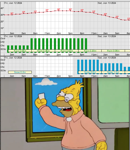
Hydrologic Outlook National Weather Service Indianapolis IN 309 PM EST Wed Jan 10 2024 …Heavy Rainfall Expected over Central Indiana Friday… An active weather pattern this week will bring a second round of heavy rainfall on Friday. Current forecast totals for Friday of around one to two inches across central Indiana with locally higher amounts will bring additional river rises after the responses from early week rains of 1 to 1.5 inches. Area river and stream levels have been very low up to this point due to ongoing drought, but this round of heavy rainfall Friday could bring many river locations to action stage, which will mean faster flows and higher stages than have been seen in quite some time. While widespread flooding is not currently expected, some smaller, faster responding streams and even a few spots along the Wabash could see minor flooding develop depending on rainfall rates and where the heaviest rain falls. Stay weather aware and monitor for any possible flood watches or warnings going into and through the weekend.-
 1
1
-
-
I hate this world.
-
9 minutes ago, IWXwx said:
Yet another miss for Northeast Indiana upcoming, especially if the King reigns. More rain and the bad thing about this one is that it will be followed by a barren arctic tundra for days on end.
I feel like a permanent resident in this forum. Misses NW or south have been a reoccurring theme.

-
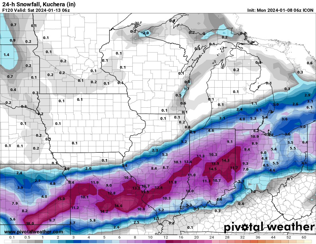
My money is on the ICON. It has been pretty locked on a very favorable track for MBY.
.thumb.png.3b7b1350931a4d384b27474d10eb01e6.png)
-
1
-
1
-
 2
2
-
-
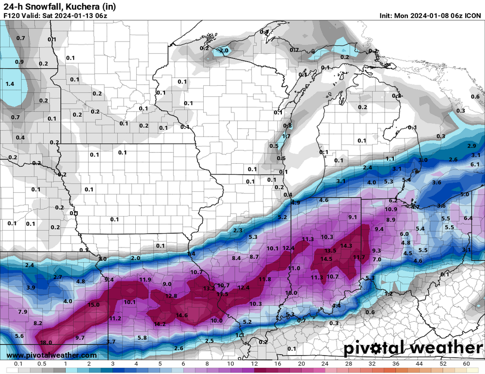
Temperatures will be marginal at best for some parts of the 1/8-1/10 storm IMBY (north central Indiana and south towards Indy). Both the GFS and ECMWF show any single digit and teens are 8+ days away which are always skeptical given past history of forecasted cold which tempers as we draw closer.

-
I know the models are showing a lot of potential in the next couple of weeks but I'm already confident I'll be on the side of cold rain and disappointment. I figured I'd get started early with my prediction.
-
Bah Humbug!

-
1
-
-
Indy NWS shared some news stories of the doppler radar installation.
-
On 9/8/2023 at 6:41 PM, cyclone77 said:
If the new Euro is correct another few weeks of waiting for rain are in order.
This weekend I am planting 37,000 square feet of grass. I need a half inch of rain every day for about three weeks or I'm going to be doing a lot of watering. Sigh.
-
NWS Indy Radar Loop
-
1
-
 1
1
-
-
-
1 hour ago, Jackstraw said:
I respect your posts RS but the 74 Big Dog? Oh my you have my ears definitely perked sir!

That day started with an earthquake in Indiana and the local radio station (WILO-AM Frankfort) was talking about that and then boom!
-
I’ve been watching this discussion. While I’m further East in Indiana, I’ll be in Indy with a couple of thousand students for a concert band and orchestra festival performing this weekend. Hopefully things settle down come later in the day.
Also, the largest show for the trucking industry is happening in Louisville. There are hundreds of show semis worth hundreds of thousands of dollars each sitting outside. Yikes.
. -
After heavy rain all day, it has become snow. Sigh.
.-
1
-
-
1 hour ago, SolidIcewx said:
It was near record warm yesterday (Indy did set a record) and model shenanigans be damned I want no part of this.
-
Radar indicated rotation on two storm north/northeast of Indianapolis prompted some warnings. No actual sightings.
-
From the IND AFD: Questions surround precipitation type as well as total liquid /
flood potential. Appreciable snow/icing on the front end of the
system does not appear likely...as long as the overall pattern`s
northern stream stays retracted and unconnected to this strong
southern wave, with the polar air, if anything retreating into
Ontario as the event starts in Indiana...which should discourage any
sub-freezing temperatures to start. -
1 hour ago, sbnwx85 said:
Just posted about that in the medium/long range thread. Trying to reel it in for us. It's probably our last hope before "spring".
Pass.
-
1
-
-
8 hours ago, MDScienceTeacher said:
Concerned downwind citizen here. Is everything okay in Ohio and the surrounding area? Based on what I am seeing, it seems like there is some sort of major environmental catastrophe happening in East Palestine.. Like someone f-ed up really bad.
If it werent for the aliens, I would think it would be major news.. but for some reason, none of the main stream outlets are covering it.
Longer and longer trains with no regard on where the hazardous cars are placed. What could go wrong. At least stockholders are making bank.
-
1
-
.png.b5b42aab1f27c9bd40f74d3d8468ddcd.png)

Spring 2024 Medium/Long Range Discussion
in Lakes/Ohio Valley
Posted
The GFS has been brutal with cloud cover.