wxmanmitch
-
Posts
2,087 -
Joined
-
Last visited
Content Type
Profiles
Blogs
Forums
American Weather
Media Demo
Store
Gallery
Everything posted by wxmanmitch
-
20° F and overcast. I think I see a tiny little under the radar snowflake from time to time too. I had a minimum temperature of -7° F yesterday, which was the coldest since last winter. I had a cheap midnight high of 7° F though since the arctic boundary didn't reach my location until around 2 AM. The daytime high was -3° F despite full sunshine. I had 3.4" of lake effect snow with 0.2" LE Sunday night through Monday night. Total snow depth is 6". While it's not much, it's a full on Currier and Ives winter scene out there with snow and ice on the trees. So much better than that garbage pattern we had December into the first week of this month with rain, freezing rain, fog, and mud. Saturday's arctic shot is the real deal, and I fully expect double digit negatives here Saturday AM for the first time since MLK Day 2019. It doesn't look like there will be a cheap above zero midnight highs either as this boundary comes in late Friday. The Sunday night and Monday storm appears be our first significant synoptic snowstorm. While it may take a track over or west of us, the storm could occlude off to the SW of us, which in essence cuts off the warm air from the low center. Although a track like this would usually be the kiss of death, not this time. Worse case scenario it could be a good front end dump followed by a dryslot with some light snow or mix. Also, an occluded storm to the SW of us could result in a nice firehouse LLJ from the E or ESE, plastering the Greens and their eastern slope with a solid 12"+ storm while the western slopes get shadowed with strong downslope winds. All of this assumes and early capture by the 500 mb low as much of the guidance currently depicts, but if that doesn't happen, the storm will probably take a more traditional coastal storm track along or just off of the shoreline. This could put us in the midlevel deformation zone with a storm that hopefully doesn't occlude as fast. Either way, there's finally some legit hope for us snow lovers in what has been a lean winter so far in NNE.
-
I had 1.7" as of 4 pm, most of it from midday. I haven't measured since then, but I've probably gotten a few tenths more since then. The best of the streamer was a bit north of me. Currently light snow and 8° F.
-
0.5" of sleet, 0.1" ice accretion, 0.48" LE. Dodged a bullet here as a lot of the precipitation was sleet instead of freezing rain. I think upslope cooling associated with the SW winds resulted in my spot having a colder p-type than many of the surrounding areas. The only non-upslope wind direction here is NE.
-
Full on scalp fest right now, 22° F. This is one of the only times I'm actually happy to be getting sleet as it would otherwise be freezing rain. Not sure how long I'll stay sleet with the WAA ongoing aloft though.
-
Happy New Year! Here are the final weather numbers for 2021 at my location 5 miles NW of Readsboro, VT (2,230' elevation): Average Temperature: 43.3° F High Temperature: 83.0° F (6/29) Low Temperature: -7.7° F (1/29) Total Precipitation: 70.40" Total Snowfall: 117.1" It was another mild and wet year with somewhat below normal snowfall. The rainfall was collected with a Stratus rain gauge.
-
Total bustogenesis! 1.2" of snow before change to sleet occurred around 3:30 pm. Straight freezing rain now at 30° F, after a 5 pm low of 25° F. Water is dripping off the roof and freezing so everything is going to be an ice rink. This storm verified about 50-60 miles north of forecast as I was expecting 4-6" of snow and sleet. I was hoping this one would work out because we have nothing else in the offing. This may well be one of those ratter winters...
-
Just an of a storm here. 1.2" of snow before sleet changeover at 3:30 pm, which was sooner than even the warmest of the guidance had forecast. Light freezing rain now and everything is crusted over. Just awful. I really hate these storms when it's 25° F and sleet here while it's 33° F and snow in the Merrimack Valley. I was expecting 4-6" of snow and sleet, but that wound up about 50-60 miles north of me. Total bustogenesis!
-
I just had a glimpse of a large, healthy bull moose on the side of the road in front of the house. Unfortunately, by the time I had grabbed my phone it had disappeared back into the patch of dense spruce/fir woods from whence it came. I drove around looking for it, but no such luck in finding it again. This was my first moose sighting in the almost 4 years I've lived here. I'll keep my eyes peeled in the hopes that I'll see it again... There's about 2-3" of crusty snow in the protected areas, but bare ground elsewhere. Snow coverage is about 50%. Almost no melting today despite a high of 41° F. Dew points in the low 20s and solar minimum FTW.
-
A nice little event. 6" OTG total since there's ~2" of old, hard stuff underneath. Gotta take what you can get in a crummy pattern and savior the moment. FYI, I planted that white oak in 2018 and it was 3'. It's now 6'.
-

December 2021 Obs/Disco...Dreaming of a White-Weenie Xmas
wxmanmitch replied to 40/70 Benchmark's topic in New England
I hope we get a pattern change soon as this weather is awful, just awful. I am always a fan of the underdog, and in this era of rapid global warming, that underdog is colder than normal weather. This is precisely why I always root for it, even in the spring and summer when most people don't want it. Well, that and the fact that I also have a strong dislike for warm, humid weather. Unfortunately, rooting for team colder than normal in this day and age often feels like rooting for the Patriots in Super Bowl XX. -
In light of bandwidth limitations on my end and on here, it's much easier for me to link photos from my Twitter than to upload onto AmWx. That said, I expect things will be large green and brown by dusk tomorrow. Maybe I'll get some snow behind the front if I'm lucky as it is something the mesos have been suggesting for a few runs now.
-
I will on my Twitter. Is there some way to link my tweets on here?
-
It'll probably be upper 40s, low 50s with similar dew points. This upcoming cutter is quite strong and should mix out the CAD around here.
-
Still have a crusty 5-6" of snow pack that survived yesterday's "torch". In addition to the 8.0" of upslope from last Friday and 1-2" from the multitude of weak clippers, I had 3.1" of WAA snow early yesterday AM before rotting in CAD fog in the high 30s all day so the melting was slow. Even Woodford reached 43° F when I was only 38° F. I didn't mix out until the thunderstorm in the evening. It went from a calm fog to a sudden freight train from the W and NW with rain, pea sized hail, and graupel. It ended as some wet snow, yielding a 1/2" of small hail, graupel, and wet (now frozen) snow. Season snow total is 18.5". Not a bad start. Too bad Monday's stronger cutter probably wipes out what is a nice solid base for the snow mobilers and cross country skiers.
-
December 2021 Obs/Disco...Dreaming of a White-Weenie Xmas
wxmanmitch replied to 40/70 Benchmark's topic in New England
3.1" of snow here overnight from the warm front. Dense fog and 36° F here now, while the west slope is already torching into the high 40s. If we can avoid a net loss with this, I'll consider it a win. -
December 2021 Obs/Disco...Dreaming of a White-Weenie Xmas
wxmanmitch replied to 40/70 Benchmark's topic in New England
November stats for my location: Average Temperature: 32.6° F High Temperature: 58.2° F (11/18) Low Temperature: 11.2° F (11/28) Total Precipitation: 3.61" Total Snowfall: 14.1" Finally a month that breaks the streak of warm, wet months... -
11/26-11/27 Rain Ending as Snow Obs/Disco
wxmanmitch replied to 40/70 Benchmark's topic in New England
8.0" of dense, windblown snow here and measurements were all over the place, but ranged between 6-10". Snow growth was poor to mediocre here. Woodford was very similar and reported 8.5" earlier. It was a strange event with the heaviest totals along the NY-22 corridor and on the Rensselaer Plateau due to low Froude numbers and the primary upslope snow cloud being just east of the Hudson River. The most reported on ALY's PNS was 13.5" 3 N of Austerlitz, NY, but I did see an unofficial 18.5" report on Facebook at 1,500-1,600' in Taborton, NY, which I think may be legit based on the photos, location, and radar imagery in that area. They were probably puking dendrites for hours on end out there. Pittsfield, MA (~8-9") had more than 2K in Savoy, MA (5.5"). This event was similar in some ways to the 11/20/16 NWFE, but this one was a little more blocked and not as long lasting. -
80° F/64° F here. High of 81° F, which is my 4th 80°+ F day already this warm season. It's hot, but not terrible in the shade since there's a breeze and the dews are still tolerable. Deer flies are nothing short of awful though as I must've had no less than 8 or 10 of them swirling around me while mowing earlier. Black flies and mosquitoes pretty much non-existent midday, but they come out in abundance around 5-5:30 pm, making for what I call the Holy Trinity of biting insects: deer flies, black flies, and mosquitoes. Alas, such is the price one must pay for being in a spot that likely averages around 12 feet of snowfall per winter...
-
There was no accumulation at my spot, not even on my white snow board. Dover tends to cool a little more efficiently on a NE flow than I do, which may explain the difference.
-
I wasn't here in 2013, but I do think it must've snowed here then as it did up on the mountain summits.
-
Rain and snow mix here, 36.0° F. I've had periods of wet flakes mixed in during the heavier bouts of precipitation since around 1 AM. This is the latest trace of snow I've ever observed in my lifetime. Amazing stuff!
-
While I need/want some rain for newly planted grass seed, too much at once is worse than none at all since you can water. That said, does anyone have tips for minimizing or preventing erosion and grass seed wash-away from heavy rain? NAM nails my location with a torrential squall line around 7-8 PM tomorrow and I have a whole bunch of loose top soil and grass seed that I don't want to lose. Ugh...
-
High end category 3 black fly conditions, category 5 pollen. Between the two, it's damn near impossible to be outside right now. Can we just skip to September please?
-
The Official, Unofficially Licensed Winter 20/21 Wrap-Up Thread
wxmanmitch replied to Cold Miser's topic in New England
137.8" season total, grade: C. It wasn't a terrible winter, but it wasn't good either. Highlights: A nice mid-December storm even though the jackpot as about 30-40 miles north of here, elevation storm in mid-January followed by a week of upslope snow showers, a month straight of subfreezing temperatures (1/16 to 2/16), and a decent wind driven snowstorm in early February. Max snow depth of 32" in late February. No torch rainy cutters after the Christmas one. Problems: Christmas cutter, boring early January, and a snowless March and early April. No blockbuster/historic storms here either. -
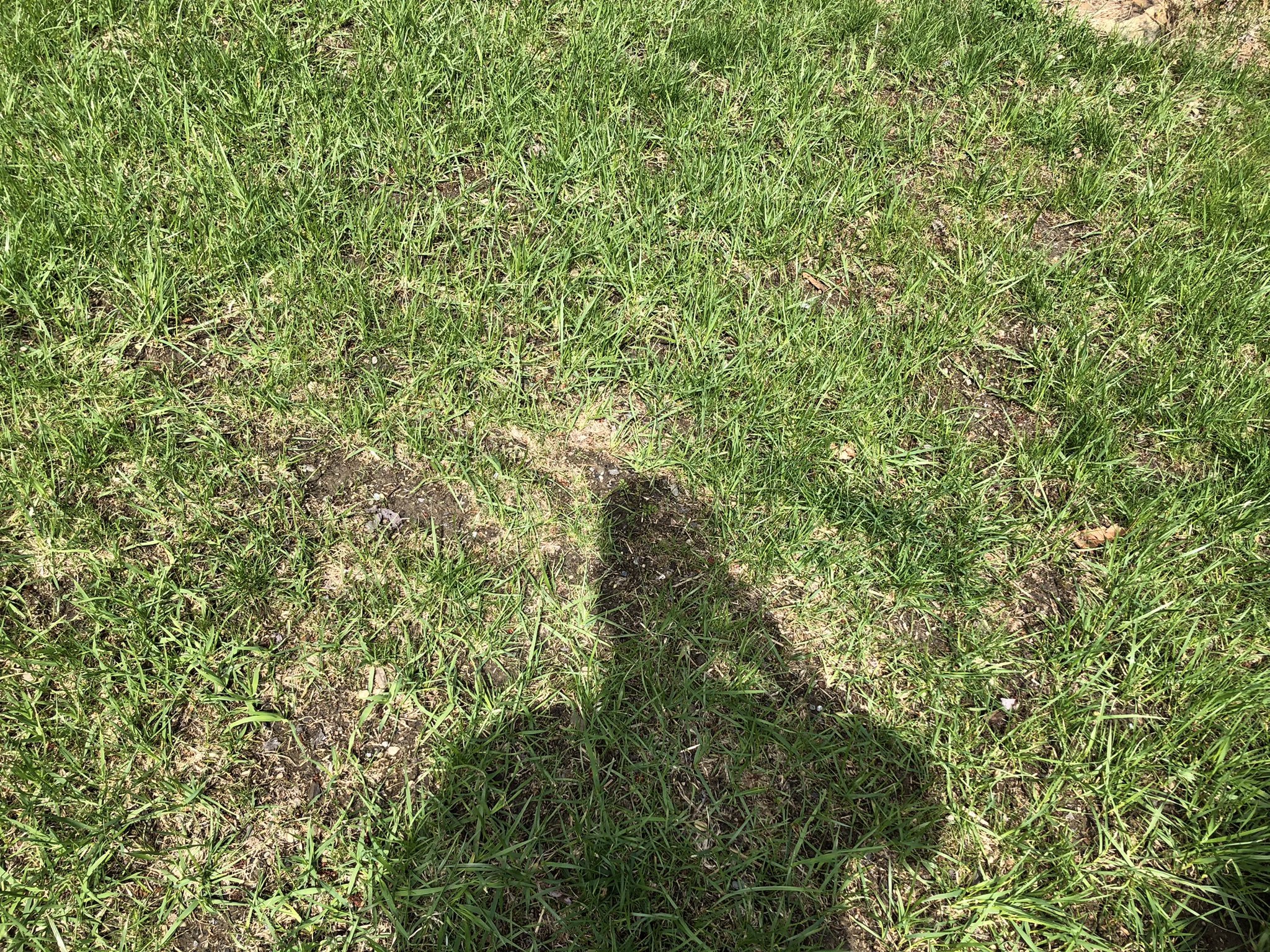
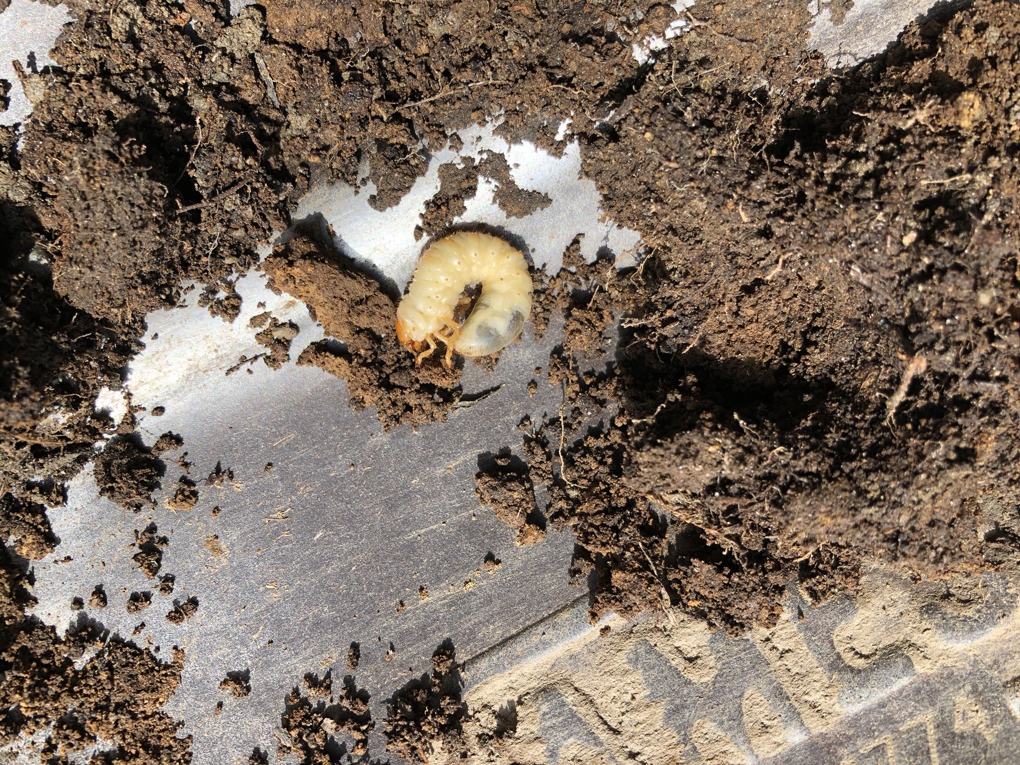
Went to investigate an area of thin grass and discovered this when I put a shovel in it. What's the best grub control and when should it be applied?