

dan11295
-
Posts
3,038 -
Joined
-
Last visited
Content Type
Profiles
Blogs
Forums
American Weather
Media Demo
Store
Gallery
Posts posted by dan11295
-
-
10 minutes ago, WxWatcher007 said:
Wheeeee

Congrats to the thriving moss imby.
Looks like a solid advisory level event for SE sections
-
 2
2
-
-
Not ready to bite on seeing warning snows here north of the pike yet. Along the pike seems very possible esp with the late bump back north.
-
Crazy how far off that is from NAM/GFS with 24 hours until start time
-
Just now, CoastalWx said:
GFS really nails HFD to BOS and NW with decent fronto I think.
Yea you def think that corridor does better than what the clown maps show.
-
Time to see what the 12z Goofus does. I am guessing it stays pretty far south like 6z
-
4 minutes ago, ORH_wxman said:
Funny how the Reggie QPF is so paltry again outside of SE MA but the H7 fronto is in the roughly same spot as NAM
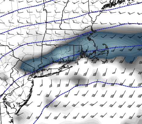
Not sure how you end up with <4" along the Pike with that setup
-
 1
1
-
-
You just don't want any more southern shifts if you are in the ORH-BOS corridor. Trends needs to stop at 12z otherwise you risk being north of the cutoff.
-
Portland was at 13.08' as of 10:48. High tide at noon. 1/10 peak was 13.84'. All the erosion that has previously occurred is really going to worsen the situation.
-
1
-
-
Just measured 3" of paste here at 5 am
-
I am selling 12"+ here tbh. Am worried even here ratios will be cut down tonight. Would really need the CCB to get going in time and everything not to be too far north to make that a reality in metrowest Boston.
-
Have to be very vary of poor ratios, etc. on the thump esp in ESNE.
-
From the MEMA outage map the south shore in particular has taken a bit of a beating. Cluster of 10+ towns all 50%+ out. 285k outages now. Not a bust.
-
260k outages in MA
-
what are the winds like in line in RI?
-
6 minutes ago, Amped said:
Surprised this is fading from the news so quickly. The damage keeps looking worse and worse as pictures come in.
Not in U.S., general lack or info and other new big stories are dominating the news cycle.
-
-
Has to be some of the worst high rise damage I have seen from a tropical cyclone
-
Looking at area weather stations, at least 10 are reporting 5-6"+ in Brooklyn now.
-
1
-
-
Yea this is really more of a NYC metro event. 4-5" in part of Brookyln so far per radar and multiple personal weather stations.
-
Medicanes have always been in this strange spot when it comes whether or not to recognize them as "tropical cyclones"/how to classify them and who should be responsible to monitoring etc. This is due to a few reasons.
1. Temperatures in the Mediterranean have historically been too cold (i.e. <28C) to allow typical warm core TC development. Some times these storms have formed well outside of the typical June-November window for Northern Hemisphere TC development. These two factors are certainly a historical reason that haven't been classified and tracked as such. Although with better analysis tools its clear many of these storms are warm core cyclones. Daniel would have certainly been named if it had occurred in the Atlantic.
2. These storms have generally been weak, really never turn into warm core hurricanes (probably due to SST limitations). With a couple exceptions have not caused notable damage or loss of life.
3 They are very infrequent.
As far as who would be responsible for tracking, the NHC doesn't make sense, as they will never effect US landmasses in any way. A European body makes much better sense.
-
1
-
-
Tbh we really don't need this. Rain from a tropical system would cause major problems right now. never mind the wind.
-
1
-
-
Just now, ineedsnow said:
those totals start september 10th.. most areas around here had a good amount of rain yesterday
Ah ok, yea i know they had some downpours there already. So everything was already very saturated.
-
Does look like the BOX radar estimates at running a bit high. highest rain gauges in the Leominster area i see that look to be accurate are in the 7-7.5" range.
-
BULLETIN - EAS ACTIVATION REQUESTED
Flash Flood Warning
National Weather Service Boston/Norton MA
722 PM EDT Mon Sep 11 2023

...FLASH FLOOD EMERGENCY FOR LEOMINSTER...

The National Weather Service in Norton has issued a

* Flash Flood Warning for...
  Northeastern Worcester County in central Massachusetts...

* Until 1030 PM EDT.

* At 722 PM EDT, emergency management reported thunderstorms
  producing heavy rain in Leominster, roadways being washed out and
  flood waters entering homes and business. Between 3 and 5 inches
  of rain have fallen. The expected rainfall rate is 2 to 4 inches
  in 1 hour. Additional rainfall amounts of 1 to 3 inches are
  possible in the warned area. Flash flooding is ongoing or expected
  to begin shortly.

  This is a FLASH FLOOD EMERGENCY for Leominster. This is a
  PARTICULARLY DANGEROUS SITUATION. SEEK HIGHER GROUND NOW!

  HAZARD...Life threatening flash flooding. Thunderstorms
           producing flash flooding.

  SOURCE...Emergency management reported.

  IMPACT...This is a PARTICULARLY DANGEROUS SITUATION. SEEK
           HIGHER GROUND NOW! Life threatening flash flooding of
           low water crossings, small creeks and streams, urban
           areas, highways, streets and underpasses.

* Some locations that will experience flash flooding include...
  Leominster, Fitchburg, Lunenburg, Lancaster, Sterling,
  Westminster, Shirley and Princeton.

The Congrats Dendrite Deck Destroyer 3/23-3/25 obs discussion
in New England
Posted
I think I am selling the 6" in Boston though