Jackstraw
-
Posts
2,268 -
Joined
-
Last visited
Content Type
Profiles
Blogs
Forums
American Weather
Media Demo
Store
Gallery
Everything posted by Jackstraw
-
Looking a little "Derechoish" on radar.
-
Starting to get some notches on that IA line, one of them warned now.
-
Cool storms to watch. They blew up around Kokomo in like 20 minutes. Alittle more shear up here and it could've gotten very interesting. Really nice radar depiction of the southern flank of the N IN line encountering the outflow from the SE IN storms that rolled through a few hours ago. Muncie has been getting pummeled with nearly 5 inches of rain in the last 2 or 3 hours under that boundary. (Time Sensitive link) http://weather.cod.edu/satrad/nexrad/index.php?type=IND-N0Q-1-24
-
Still hazy here but dews are definitely on the uptick. I'll be out running some errands around 2 so hopefully I can catch something along the warm front. Radars around the area have been cool to watch with these little vortices spinning around the main low. http://weather.cod.edu/satrad/nexrad/index.php?type=ILX-N0Q-1-24
-
The one to the north by Marshalltown starting to rev up.
-

2018 Short to Medium Range Severe Thread
Jackstraw replied to tornadohunter's topic in Lakes/Ohio Valley
If that ridge was just centered 150 miles east it would be game on. -
Spring/Summer 2018 Banter and Complaint Office
Jackstraw replied to IWXwx's topic in Lakes/Ohio Valley
I'm 2 miles from IWX's AFD. I don't know how many times I check the P&C to my north just inside their AFD area and the forecasts are different than just inside IND's. Usually not by much but occasionally there's a decent spread. And sometimes it just seems like they're betting with each other. For instance, IWX has Friday as the hottest day at 95 2 miles to my north with Saturday at 93 and IND has us at 92 on Friday and 94 on Saturday for this mini heatwave. Sometimes I wonder if the occasional beer isn't on the line or some season long bragging rights lol. Boring weather brings about boring posts -
2018 Short to Medium Range Severe Thread
Jackstraw replied to tornadohunter's topic in Lakes/Ohio Valley
Yes, this stubborn pattern has got to go. If we can get some decent shear tomorrow maybe we can get something to sneak in before you leave! Good luck to you. Hope you'll still post your thoughts around here from time to time. Always enjoyed your insight! -
19/10/4 June 2/1/0 July 3/1/1 August 4/2/1 September 8/4/2 October 2/2/0 November 0/0/0
-
Well Ryan said google it lol. https://en.wikipedia.org/wiki/List_of_Arabian_Peninsula_tropical_cyclones That would be an amazing sight especially just after landfall. I wonder if there is plant/animal(not necessarily multi cell) life in the area that lays dormant until such an event happens.
-
Spring/Summer 2018 Banter and Complaint Office
Jackstraw replied to IWXwx's topic in Lakes/Ohio Valley
Been the curse all Spring if Spring is what you want to call it lol. -
Spring/Summer 2018 Banter and Complaint Office
Jackstraw replied to IWXwx's topic in Lakes/Ohio Valley
What is this cold liquidy substance falling from the sky? I think it's an alien invasion or its been so long I can't remember! The whishy washy front is right over us. I was 2 miles to my south at friends and his thermometer said it was 74 degrees. Drove home 2 miles north not 5minutes later and it was 61. You could tell the marked difference in the air mass, dews, temps etc. Pretty freaky. Only in the Midwest lol. -
2018 Short to Medium Range Severe Thread
Jackstraw replied to tornadohunter's topic in Lakes/Ohio Valley
Day 4-8 Convective Outlook NWS Storm Prediction Center Norman OK 0354 AM CDT Sun Apr 08 2018 Valid 111200Z - 161200Z ...DISCUSSION... The primary feature of interest during the extended period will be a deep/amplified mid-level trough that will reach the central US by D6/Fri. As it does so, strengthening west/southwesterly flow aloft will transport steep lapse rates over much of the southern/central Plains. Meanwhile, a robust low-level mass response will feature a narrow corridor of enhanced poleward theta-e transport, generally from eastern Texas to the lower Missouri Valley. As a dry line and cold front accelerate east across the region, low/mid-level ascent is forecast to strengthen sufficiently to overcome convective inhibition and promote thunderstorms from eastern Texas to parts of the Midwest through Friday night. While medium-range guidance continues to exhibit run-to-run variability with regards to the amplitude/timing of the trough, most deterministic/ensemble guidance suggest strong/severe thunderstorms will be most likely from eastern Texas to the Ozarks and Mid-South Friday afternoon through the overnight. Within this corridor, vigorous low/mid-level wind fields should overlap adequate surface-based buoyancy, such that all severe hazards may be possible with maturing convection. Therefore, a 15-percent probability has been introduced with this forecast cycle. Further refinements of this area (with some potential for a northward expansion) will likely be needed in future updates. The trough will advance further east through D7/Sat-D8/Sun, with pockets of strong/severe convection potentially persisting across areas from the Ohio Valley south to the Gulf Coast. Despite this potential, uncertainties regarding availability of adequate instability, the eastward evolution of the trough, and subsequent timing/placement of stronger convection remain too high to introduce probabilities beyond D6/Fri. ..Picca.. 04/08/2018 -
weather Top 4 sites to see the weather
Jackstraw replied to jackchoune's topic in Weather Forecasting and Discussion
Thread needs deleted. Malware. -
Spring/Summer 2018 Banter and Complaint Office
Jackstraw replied to IWXwx's topic in Lakes/Ohio Valley
Stop it already!!!!.thumb.png.b678635024d197fc1fc7152ceed35d8c.png)
-
Spring/Summer 2018 Banter and Complaint Office
Jackstraw replied to IWXwx's topic in Lakes/Ohio Valley
Seriously?..... Tonight Showers, mainly after 8pm. Low around 45. South wind 15 to 18 mph, with gusts as high as 29 mph. Chance of precipitation is 90%. New precipitation amounts between a half and three quarters of an inch possible. Tuesday Showers. High near 56. South southwest wind 15 to 17 mph, with gusts as high as 29 mph. Chance of precipitation is 100%. New precipitation amounts between a half and three quarters of an inch possible. Tuesday Night Showers. Low around 45. South southwest wind 5 to 8 mph becoming north after midnight. Chance of precipitation is 100%. New precipitation amounts between a quarter and half of an inch possible. Wednesday A 30 percent chance of showers before 2pm. Cloudy, with a high near 59. North northeast wind around 6 mph becoming light and variable. Wednesday Night A 40 percent chance of showers, mainly after 2am. Mostly cloudy, with a low around 44. Light west northwest wind. Thursday Showers likely, mainly between 8am and 2pm. Mostly cloudy, with a high near 55. Chance of precipitation is 60%. New precipitation amounts between a quarter and half of an inch possible. Thursday Night A 50 percent chance of showers. Mostly cloudy, with a low around 36. Friday A 40 percent chance of showers. Partly sunny, with a high near 48. Friday Night A 40 percent chance of showers before 2am. Partly cloudy, with a low around 31. Saturday A 30 percent chance of showers, mainly after 2pm. Mostly sunny, with a high near 50. Saturday Night A 40 percent chance of showers. Mostly cloudy, with a low around 33. Sunday A 30 percent chance of showers. Partly sunny, with a high near 51. Sunday Night A 30 percent chance of showers. Mostly cloudy, with a low around 34. Monday Showers likely. Mostly cloudy, with a high near 49. Chance of precipitation is 60%. -
Spring/Summer 2018 Banter and Complaint Office
Jackstraw replied to IWXwx's topic in Lakes/Ohio Valley
^The pattern we're in is hell bent on making my winter miserable so why not ruin Spring with snow -
-
-
The August 21, 2017 Great American Eclipse
Jackstraw replied to ice1972's topic in Weather Forecasting and Discussion
We packed a tent and coolers and headed out Saturday morning with an idea but no plan. I had been watching the forecast and far western KY kept improving. Finally chose to go "somewhere" East of the Shawnee National Forest in IL across the river in KY for a few reasons. It was fairly close for us to drive, 300 or 400 miles. The forecast was giving us a better than 80% chance of no clouds. There's really nothing in that area but hills, farm land and little KY towns pretty spaced apart . There's only a couple of places to cross the Ohio to get into that area and they're about 50 miles apart. So I figured fairly remote, if the clouds role in to the NW in the center of the Carbondale madness, the 2 bridges are going to bottleneck the crazies trying to make a mad dash to find the sun, then that area would be a perfect place to enjoy it and not have the crowds or madness. Military strategy, we had a good defense in that area lol. Question was where to camp? Not knowing the area very well and unbeknownst to me, my girl got on FB and started searching for some folks in that area. Lo and behold she started up a conversation with a wonderful couple who had a big plot of wooded land right in the general area we were targeting.. After she spoke with them on the phone and turned on her charm they said we could camp there under the condition it was just us. They were really concerned about their property and the hype of the tons of people flowing into the Carbondale Hopkinsville corridor. We assured them it was just us and we would gladly pay and take care of their property like it was our own. Still hesitant they wouldn't tell us exactly where it was at, they just said call when we cross the Ohio. When my girl told me I said hey, we either got a place to camp or we're gonna be on one of those real life mystery crime documentary's! So we headed out and along the way we planned our escape for after the eclipse kind of making notes for escape routes if we got stuck in traffic. Regardless it all worked out great when we got down there, the folks were awesomely gracious and we all hit it off and had a blast. Come to find out they wanted to experience it in a similar manner as we did. Alone and reflective with someone you care about. I had targeted the area south of Morganfield KY and thats where we ended up. about 5 miles from the center line. The trip back wasn't bad. It really paid off taking some time to plan escape routes. We didn't spend more than 10 miles on any road with an "I" in front on the way back. Hardest parts of the trip home were the Ohio and Wabash river crossings, definitely bottle necked at both. But as soon as we crossed we hit the secondary's and the thirdendary's and even fourthendaiy's lol. Think storm chasing experience helped, the escape plans, plus two of us sharing the navigating and driving was a plus. It truly was an awe inspiring experience, well worth the minor headaches here and there on the road. I really can't add much more than what other's have already said about the actual event other than as awesome as it was, it was truly humbling at the same time. Really put's you in your place in this vast universe. Oh, and during totality , seeing it in person the pure 3 dimensional view really stood out. Pictures and video cannot reproduce that. Amazing! Besides the Eclipse we really did meet some great new friends and hope to spend some time with them again soon and repay their hospitality. Truly wonderful and memorable all around. -
Just got home about 30 min ago. Filled the tank this morning and we bolted about 30 min. after totality. 5.5 down 7 hours back. Maybe 10 miles on any road with an "I" in front on the way back. Hardest part of the trip home were the Ohio and Wabash river crossings, definitely bottle necked at both. But as soon as we crossed we hit the secondary's and the thirdendary's and even fourthendaiy's lol. Think storm chasing experience helped plus two of us sharing the navigating and driving was a plus. Any way awe inspiring experience, well worth the headaches here and there. Really can't add much more than what other's have already said other than as awesome as it was, it was truly humbling at the same time. Really put's you in your place in this vast universe. Oh, and during totality , seeing it in person the pure 3 dimensional view really stood out. Pictures and video cannot reproduce that. Amazing! Hope everyone gets home safe!
-
Wow, I want more. Wow
-
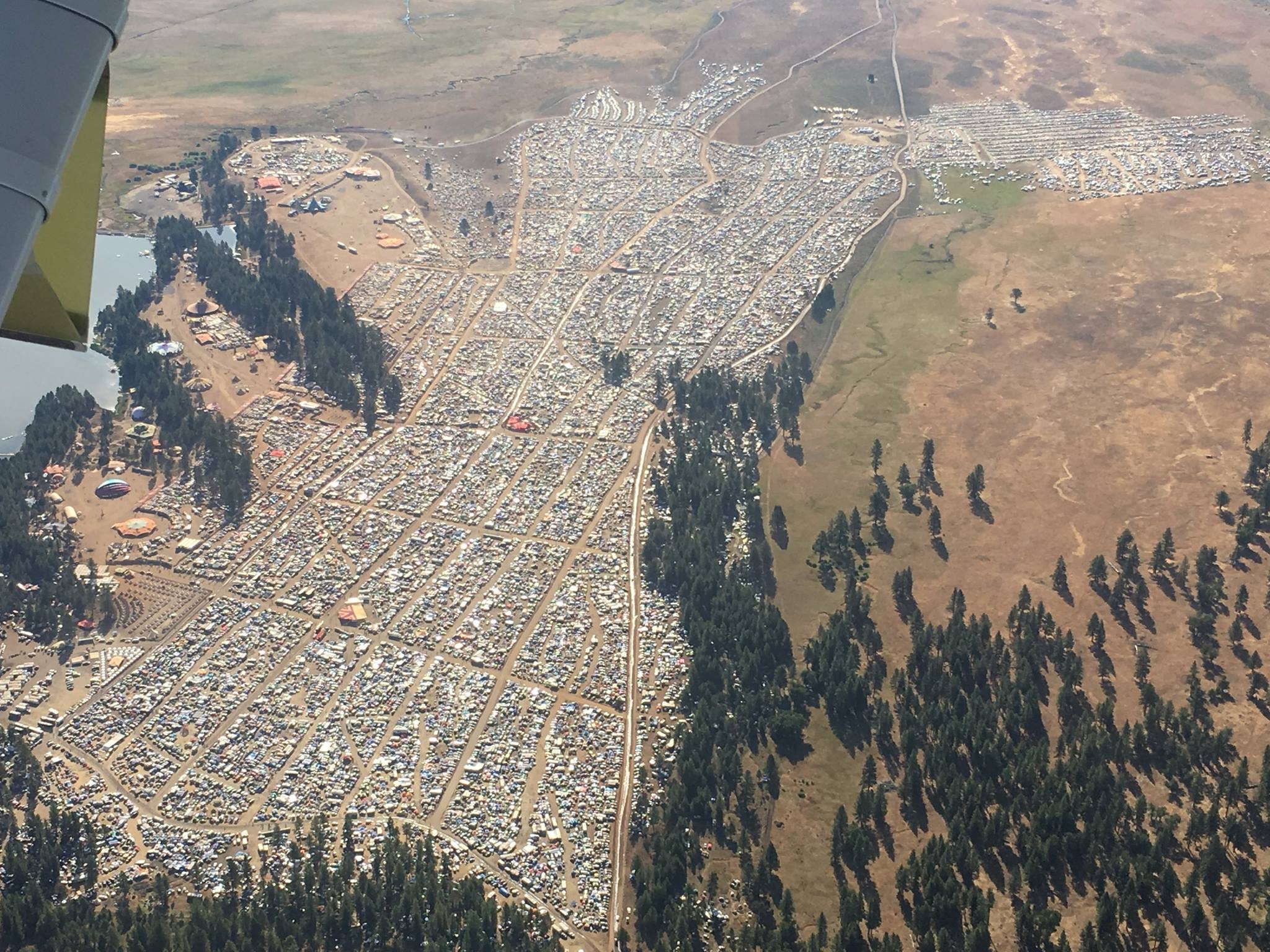
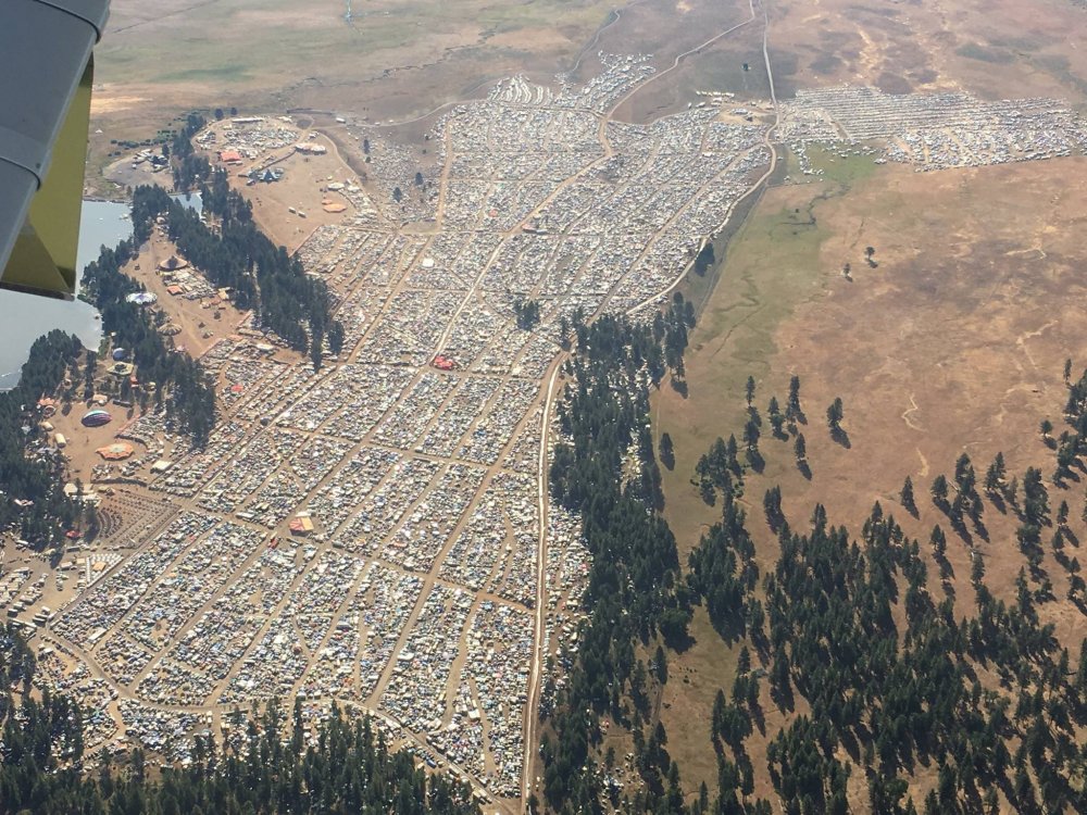
This is about 20 miles from my friends house outside Bend Oregon on Staurday. He said there are 4 of these tent cities set up outside of town and this is the smallest!
-
Found a wonderful couple on FB that let us camp on their property in western KY. Been out and about and there's not much happening around here, well, because there is nothing around here! Literally in the middle of nowhere which is nice. Barely have cell service. Just leaving Mantle Rock Preserve after a morning a walk. Heading back to break camp and drive around the hills for awhile. I'm sandwiched between 133 and 135 near Lola about 3 miles from totality. Forecast is about as good as you can get for here atm. I'm not going to get into the crowds to my SE or NW so if it happens here it happens
-
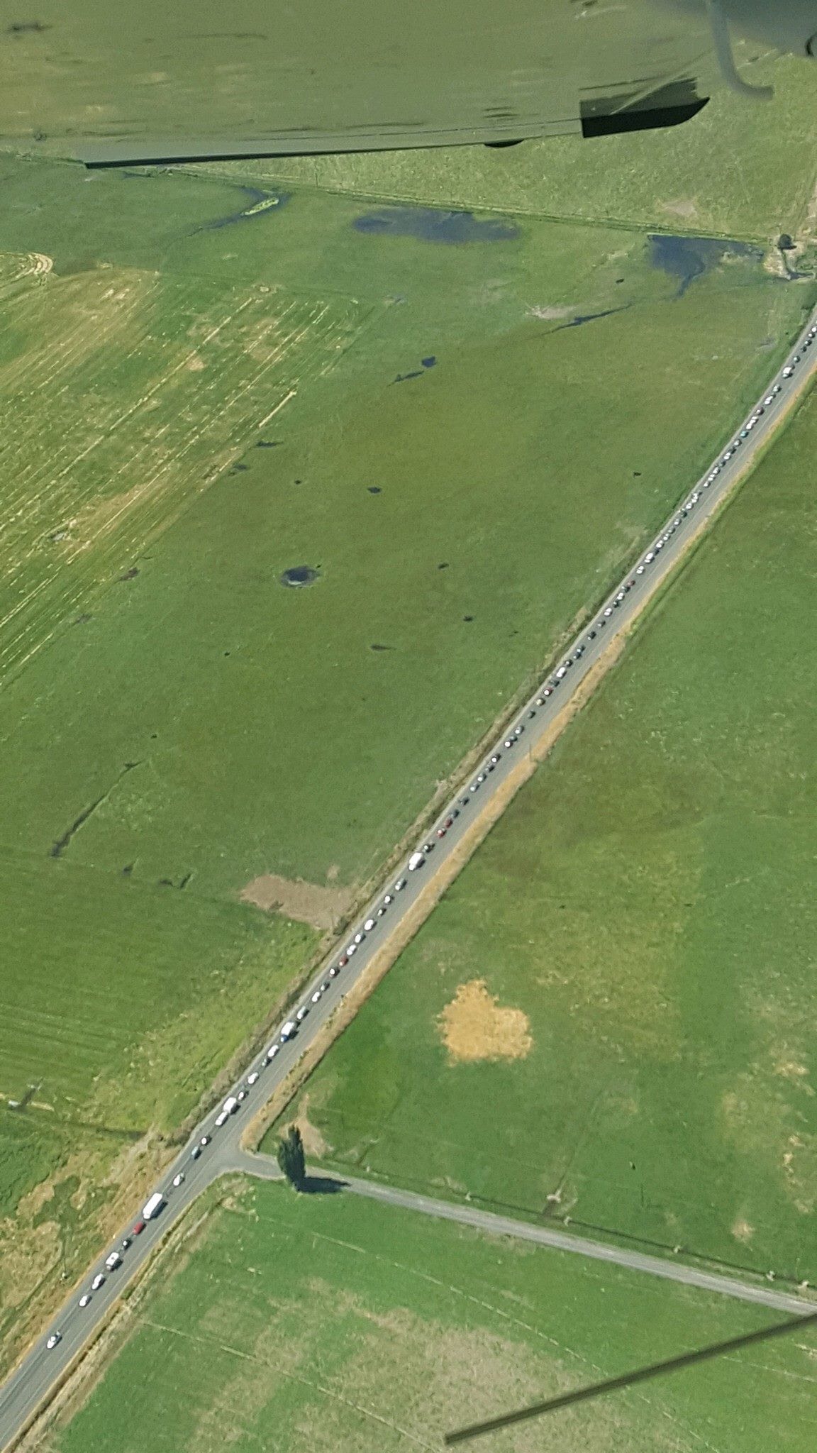
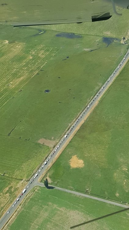
Friend of mine lives just outside of Bend Oreogon sent me this. Said traffic was at a dead stop for 15 miles. He said he had to wait 30 minutes in line for fuel and some of the gas stations are running out of gas....


.png.2d29ddac524c83f72eae263d3eb9be6b.png)