

Jackstraw
-
Posts
2,268 -
Joined
-
Last visited
Content Type
Profiles
Blogs
Forums
American Weather
Media Demo
Store
Gallery
Posts posted by Jackstraw
-
-
Yay my whole area is getting a tornado watch too. Was feeling left out

-
Nice 10 second 65mph sustained with that globular cluster that just went through.
Not one lightning strike. Started having SE coastal living flashbacks lol
-
 1
1
-
 1
1
-
-
1 minute ago, sbnwx85 said:
It’s certainly odd getting most of the severe weather of the day in the morning. A cell to my southwest went warned for ping pong ball size hail. At this point I think we may get some spin ups along the squall line but I don’t know that we’ll get an outbreak. It felt nice to let the dogs out in shorts and a tshirt.
You dress up your dogs?

-
8
-
-
50 minutes ago, A-L-E-K said:
It's your moment michigan
Hey, I'm in that box too. Too hell with Jupiters magno rings Quantum entanglement is forecasting a big dog here. My fishing reel looks like Phyllis Diller's hair and I'm sick of messing with it.

-
Oh, I caught 12 crappie so stormsa comin' lol. Just hope I'm not frying flying fish over the wee houurs of the morning

-
 1
1
-
-
1 minute ago, SolidIcewx said:
That’s a hell of a clash
Yeah its right along the dry line. We were getting a crazy dry line Friday in E Kansas also. That one Friday was a TX flying tumbleweed dryline, we don't see those that strong and defined up here often.
-
Im goin' fishin'. If they're bitin' the storms a comin' lol.
-
6
-
-
9 minutes ago, sbnwx85 said:
All eyes are on today but I'm getting more and more concerned about tomorrow's potential. I haven't seen this kind of wording used by this NWS office in a long time.

Part of the reason is until Friday we've had crap for even garden variety storms in the spring for the last 3 or 4 years. I mean seriously, our March-June thunderstorm season has sucked horribly. We're not used to it anymore lol.
-
1
-
-
Starting to see a line of agitated cumulus forming from ILX towards the triple point near Omaha along the warm front. 80/65 running into 55/45. Not the best moisture feed but it's still not bad. Some pre-frontal cells trying to go in MO
-
1
-
-
2 hours ago, hawkeye_wx said:
I just realized the core of this powerful storm is hitting Cyclone's house as I type. He's probably getting golfball to baseball size hail right now. He may be at work, though. I hope he doesn't get too much damage.
Hope he brought his helmet to work
-
1
-
-
4 hours ago, Roger Smith said:
Perhaps obvious but there seems to be high potential for this outbreak to continue most of the night 4th-5th across IL, IN, w OH and s MI, pause slightly and redevelop in OH-KY-TN on Wed 5th..It doesn't look a lot different from 4-4-74 to me. (the dynamics with this one are somewhat further north)
I respect your posts RS but the 74 Big Dog? Oh my you have my ears definitely perked sir!

-
6 minutes ago, weatherbo said:
A few more pics as the sun tries to make an appearance. Sitting with just under 4' otg.
Is it okay to root for Spring now?
.thumb.jpg.749c3c97459d6a9a1ef3ead63f78230e.jpg)
.thumb.jpg.57a31628bfb4937a289059241dc4b93f.jpg)

I barely had 10 inches this year. I hate you lol

-
4
-
-
Trey over at Convective Chronicles did a nice little video about a possible trend between a super (>2years) La Nina to El Nino transition during the early Spring months and an uptick (actually more normal) in tornado outbreaks in tornado ally and the Ohio valley in his tornado forecast for this Spring. We've been in a pretty boring dry spell for even simple pop up severe weather around here the past few years.
After yesterday and the outlook next week its definitely looking more interesting this year than the massive boredom the last few years around here. While long range fantasy land is showing the cold/snow hanging on in the northern Plains and northern Great Lakes there are continued signals of good quality airmass divergence and favorable storm track zones along those boundaries from the plains through the lower Great Lakes and the Mid Mississippi/Ohio Valley's. The South cant have it all all the time and I'd bet they'd like a break. JMO

-
4
-
1
-
-
Man seems like an unusual increase in long duration tornadic systems this year so far. This is like the 3rd or 4th continually producing tornados for 24hrs or more. At least seems like it, too tired to check.
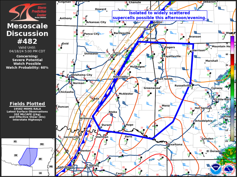
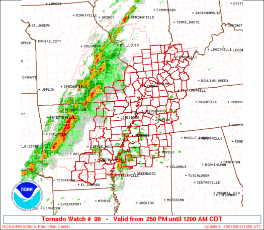
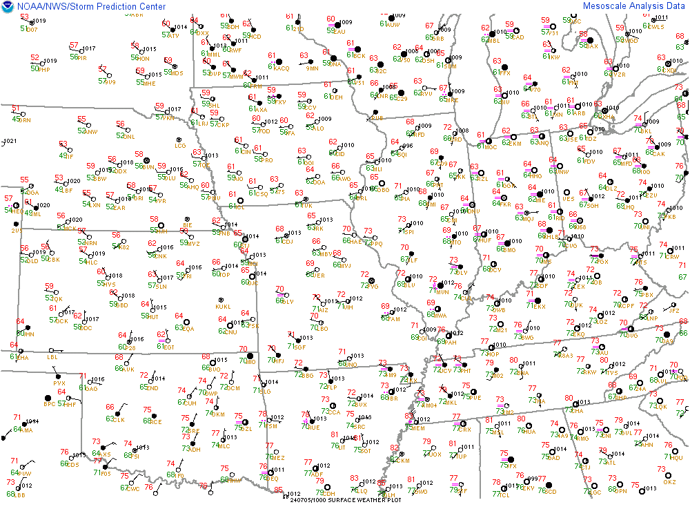
 Mesoscale Discussion 0424
   NWS Storm Prediction Center Norman OK
   0113 AM CDT Sat Apr 01 2023

   Areas affected...Middle Tennessee...northeastern Mississippi...and
   northwestern Alabama

   Concerning...Tornado Watch 101...

   Valid 010613Z - 010745Z

   The severe weather threat for Tornado Watch 101 continues.

   SUMMARY...Severe storms -- capable of producing damaging winds and
   tornadoes -- continue moving eastward across the Tennessee Valley
   area.

   DISCUSSION...Latest radar loop shows a band of storms moving across
   Middle Tennessee and northeastern Mississippi at this time, with
   several embedded severe/rotating storms.  Along with risk for wind
   gusts in the 60 to 70 MPH range, a few storms appear to be either
   currently tornadic, or capable of producing a tornado in the near
   term.

   Two of these supercells -- one now moving into southern Prentiss
   County in northeastern Mississippi and the other crossing central
   Pontotoc County in northeastern Mississippi -- both appear to have
   produced tornadoes within the past 15 to 30 minutes.

   Given the degree of shear indicated by KGWX and KHTX WSR-88d VWPs,
   and mixed-layer CAPE in the 1000 to 1500 J/kg range, the environment
   downstream from the ongoing storms remains favorable to support a
   continuation of risk through the remainder of WW 101, and
   potentially farther east still -- which may require new/downstream
   WW issuance into eastern Tennessee.
-
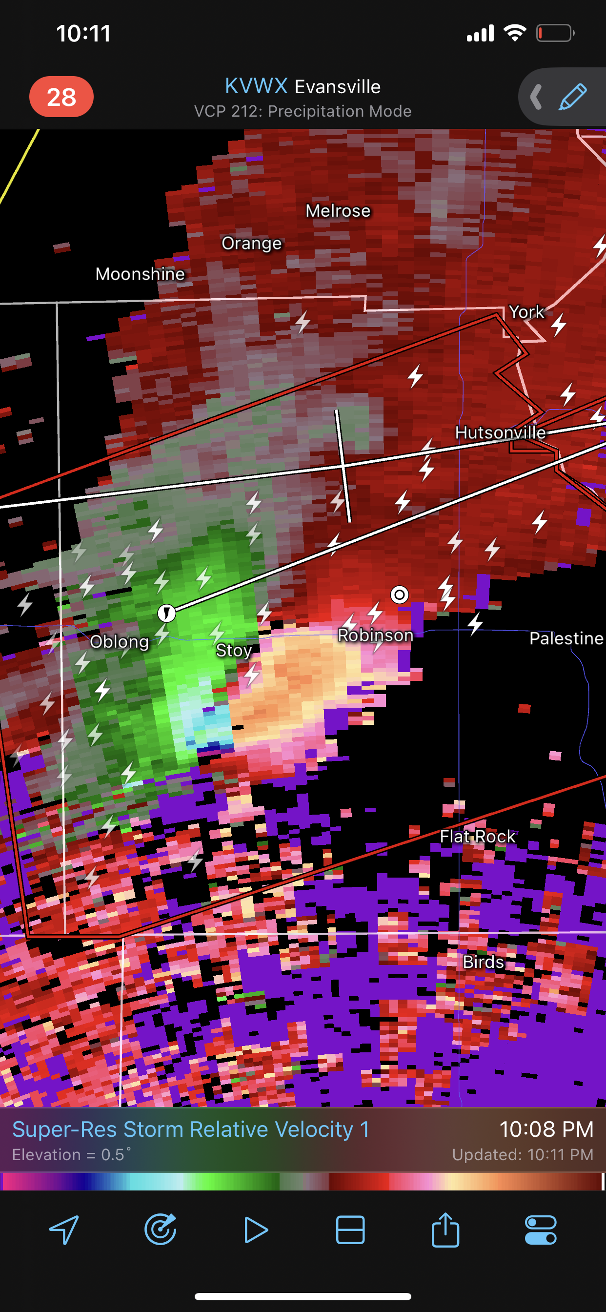
1 minute ago, Chinook said:
It looks like this is it... the debris may be recent or perhaps wafting north into the storm
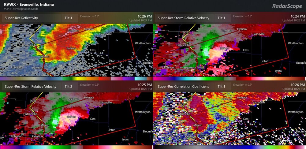
It may have been right before that or right after. I was getting pissed because my phone wouldnt screenshot it but It was a huge nearly perfectly round ball. I was on KIND's radar too I think.
-
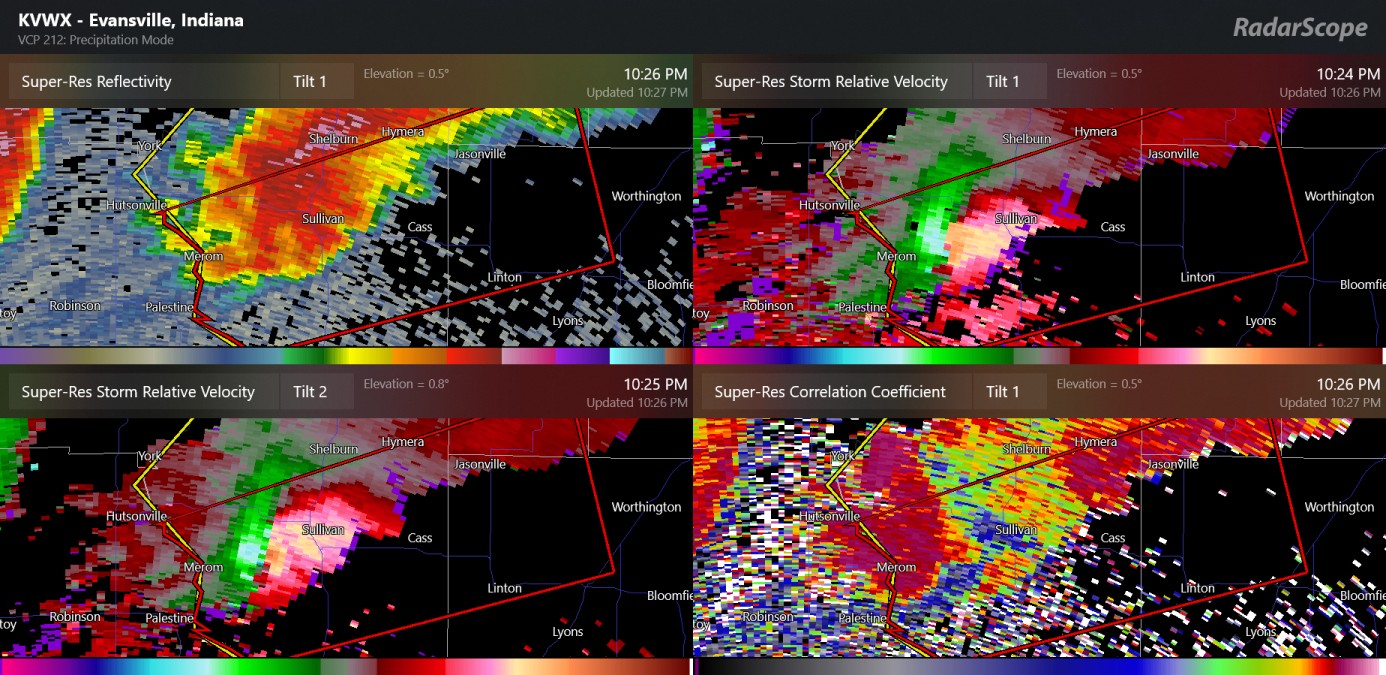
46 minutes ago, andyhb said:
Sullivan tornado had debris evident at 29k feet from KLOT after it struck town. Was likely violent. Initial reports are not good.
Wish I had a screenshot of the debris ball when it happened. I swear I've never seen one that big and it lingered in the storm for nearly an hour. It was insane. There's not much emergency infrastructure in that area. That area of SW IN is one of the poorest areas in the country.
Edit: I go fishing and camping around that area a lot. Know it pretty well.
-
That SW IN cell is getting ready to move into some decently populated areas like Martinsville. Cookie cutter subdivisions from hell around there
-
8 minutes ago, andyhb said:
Sullivan IN just took a direct hit. TDS exploded.
That was one of the biggest debris balls Ive ever seen
-
10 minutes ago, miller.b.time said:
This is just insane.
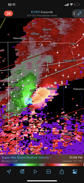
Big debris ball on that thing
-
Mack Daddy Mfer right there...
-
Wow pretty amazing system...
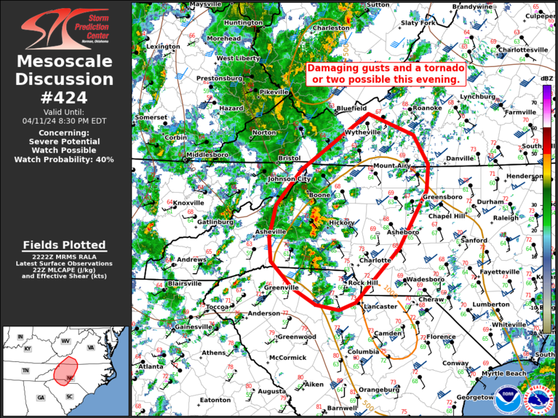
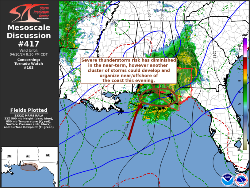
 Mesoscale Discussion 0417
   NWS Storm Prediction Center Norman OK
   0754 PM CDT Fri Mar 31 2023

   Areas affected...Northern and Eastern Illinois...Southeast
   Wisconsin...Western Indiana...Far Southwestern Lake Michigan

   Concerning...Tornado Watch 96...

   Valid 010054Z - 010300Z

   The severe weather threat for Tornado Watch 96 continues.

   SUMMARY...A threat of tornadoes, wind damage and large hail will
   continue across much of WW 96 over the next 2 to 3 hours. Parts of
   WW 96 may need to be extended in time, beyond the 03Z expiration.

   DISCUSSION...The latest radar imagery from Chicago shows a line of
   severe storms moving eastward at nearly 70 knots across northern
   Illinois. This line is located within the nose of a 500 mb jet,
   which is creating very strong large-scale ascent across central and
   northern Illinois. This combined with about 75 knots of deep-layer
   shear, evident on the Chicago WSR-88D VWP, will be very favorable
   for severe storms. In addition, RAP forecast soundings near Chicago
   increase 0-3 km storm-relative helicity into the 300-350 m2/s2 range
   by 02Z. This suggests that the tornado threat will continue early
   this evening as the line approaches the western Chicago Metro.
   Tornadoes will be most likely with supercells embedded in the line,
   and with rotating elements associated with short bowing line
   segments. As the line moves eastward into the Chicago and Milwaukee
   metro areas, wind speeds could reach as high as 80 knots along the
   leading edge of the line.

   To the south, other more discrete storms are located to the east of
   Lincoln, Illinois. This area is just to the north of an 850 mb jet.
   For this reason, a tornado threat will likely be maintained with
   these storms. A widespread wind-damage threat will also be likely
   with the stronger cells, especially if a nearly continuous line
   segment can organize.

   ..Broyles.. 04/01/2023
-
Sorry if already posted
-
Insane warm dry line kicking in from the SW ahead of the front, 78/16in eastern KS
-
1
-
-
Man the radar dried up like a Stephen Wright stand up routine. It didn't just move out, it vanished. Pretty crazy.
-
2
-

.jpg.6e0dd6dad5d3176f7fd8c9b0645c5e9c.jpg)
.jpg.15a56ce56590a33ae0d5fd1659442162.jpg)

Spring 2023 Medium/Long Range Discussion
in Lakes/Ohio Valley
Posted
Hell its 87-88 in KY and OH now. Thats pretty stout for the first week of April. Especially OH