

moneypitmike
-
Posts
29,868 -
Joined
-
Last visited
Content Type
Profiles
Blogs
Forums
American Weather
Media Demo
Store
Gallery
Posts posted by moneypitmike
-
-
Is rgem next? If whatever comes out next reverts to a hit, I’ll be on board. I guess right now we have the nam(s) and icon.
-
2 minutes ago, ORH_wxman said:
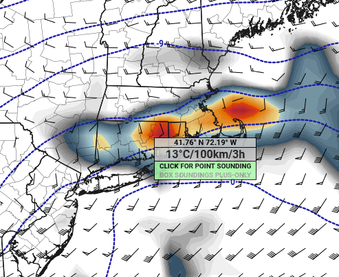
Agreed....QPF is very useful, though even that can be iffy at times, but QPF is an order of magnitude better than snow maps. When it comes to coastals, give me some good Mid-level maps with fronto and a few soundings....the QPF map can then be used with those other variables to get a more accurate picture of the potential snowfall.
Be that as it may, the nam and 3k clowns sure are purdy this morning.
-
 1
1
-
-
4 minutes ago, ORH_wxman said:
This is poundtown look at H7
Bump that a little more.
-
1
-
-
Last night I joke a Trenton jack.
-
36 minutes ago, ineedsnow said:
amazing how all the models suck
-
1
-
 2
2
-
-
2 minutes ago, Damage In Tolland said:
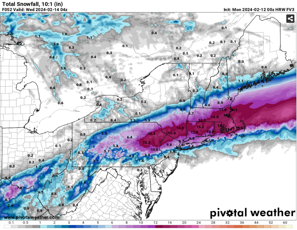
That 00z HREF is an absolute crushjob pike south . Impressive
At the rate this is going, it'll be an 84-South job at 12z.
-
1
-
-
5 minutes ago, joey2002 said:
BOX isn’t buying the trend apparently or they’re just going with the HREF
They might want to coordinate their map with their AFD.
A significant Winter Storm impacts southern New England through
Tuesday. The latest suite of guidance has trended further to the
south, but this quick hitter is expected to bring a large area of 6-
12" of snow . Localized totals over a foot are possible from
northern CT, RI, along and south of the MA Turnpike given the trend
southward. This is where there could be some snow banding as
indicated by HREF snowband probs. Still have uncertainty on the
northwestern extent of precip along with snow amounts and ptypes
along with snow accums across Cape Cod and the Islands.......
......
There is some concern in the snowfall
totals realized as there could be a tight NWly precip gradient the
UKMET, GEM and NAM indicate. These areas will have much better SLRs,
so these issues could be overcome. Due to this uncertainty have left
up the Winter Storm Watch for now.
-
2
-
-
-
I'm selling the 10-16" that BOX has in m y p/c
-
-
-
-
2 minutes ago, Ginx snewx said:
No it's better in warm environments
I have no idea when to use that vs 10:1
-
2 minutes ago, JKEisMan said:
HREF should be interesting later tonight. The individual ensemble members are coming in pretty zonked, e.g.
Was just about to post I'd like a helping of the FV3.
-
-
-
I'm still pretty sure a snow day is in order on Tuesday.
-
6 minutes ago, 40/70 Benchmark said:
Lots of spiking based on clown maps.

Lots of dread as well.
How funny is it they're making a remake of Twister. lol
-
-
8 minutes ago, RUNNAWAYICEBERG said:
We needed a day like today to be confident. We know our climo here and how these trends inside 72hrs so today was clutch.
48 hours to continue trending. Trenton bound.
")
-
The Canadiens might have been right all along.
-
 2
2
-
-
37 minutes ago, RDRY said:
Everything trending away from a central/northern Berks hit.
28 minutes ago, RDRY said:It's uncanny. The second the NWS went to a Winter Storm Warning for the southern Berks, the next round of models dropped totals in half. They couldn't have waited one more hour to commit?
-
1
-
 1
1
-
-
1 minute ago, RDRY said:
Everything trending away from a central/northern Berks hit.
are people congratulating MVY yet?
-
thanks for having me put down the toaster.


Following a Miller A/B hybrid type coastal potential, Feb 13th ... As yet untapped potential and a higher ceiling with this one
in New England
Posted
Model mayhem continues while only 20 hours out, and most of mass straddles a range between paltry and major. Goodness.