

snywx
-
Posts
10,049 -
Joined
-
Last visited
Content Type
Profiles
Blogs
Forums
American Weather
Media Demo
Store
Gallery
Posts posted by snywx
-
-
2 hours ago, CPcantmeasuresnow said:
1.4 inches of snow here. Somewhat unexpected this morning. Plow actually woke me up at 6 am.
I was stuck at 29.3 inches for the season for so long I gave up any hope of reaching 30. Now that that's accomplished I can officially give this Winter the D- it so rightfully deserves.2 hr delay here for the kids.. About 1.5” here
-
This is wild right now
33 w/ heavy snow falling
coating on all surfaces
-
 3
3
-
-
51 for a peak gust here
-
Beautiful morning here
53 w/lots of sunshine
-
1
-
-
1 hour ago, the_other_guy said:
You need to be in striking range of normal to date right?
Yeah one more big one and I’m right there. From my records in 21 yrs I avg 54.8.
-
1
-
-
2.4" here
35.8" ytd for the season
-
1
-
-
2.4" here
35.8" ytd
-
2
-
-
26/14 here
whatever falls here will be pure powder.
-
Even up here we are now looking at 2-3". IMBY we arent far from where we should be in terms of ytd snowfall. Approaching 40" after this with another 4-6 weeks to go
-
2
-
-
2 minutes ago, Stormlover74 said:
My understanding was the severe weather or lack thereof down south threw everything out of whack regarding placement of the low but I'm sure someone can explain it better
But the placement of heavier snow ended up staying N. All modeling at the last minute shifted all the goods further south. For the Euro to shift the way it did is a rarity especially inside of 24 hrs.
-
To be fair outside of the UKMET & GGEM, modeling was pretty consistent & spot on till all hell broke loose 24 hrs prior to the event. The 12-14" that fell here in Orange county was modeled for quite a while till 12z yesterday. Was it ingestion of bad info that led to every single model to fail so close to the event? I mean up until game time every single piece of guidance had mby receiving 1-2".
I believe the HREF was the only piece of guidance that continued to show 10"+ up here
-
Whats funny is that the final amounts throughout the area seem consistent with what was modeled 36 hrs ago lol
-
5
-
-
23 minutes ago, CPcantmeasuresnow said:
12.7 here for my final.
Most of Orange County NY was around a foot.
Looks like 12-14" throughout. Areas from Port jervis to Warwick on the Orange/Sussex border were 14-15"
-
3
-
-
8 minutes ago, HVSnowLover said:
About 5-6 inches here I'd say. Amazing looking at some of the reports north of here. Euro was awful.
A general 12-14" fell throughout Orange county
-
4
-
-
Storm is done here. Back edge is hauling east
13.1" final
33.4" season year to date
-
7
-
-
1 minute ago, Nibor said:

That back edge is beautiful.
Heavy snow too..
Im currently in it. Should clear out within the next 30 mins
-
2
-
-
12.4" otg
Moderate snow falling.
Looks to be ending by 11am
-
4
-
-
29° w/ moderate snow
12.4" otg
additional 1-2" is doable before the sun comes out
-
6
-
-
30 mins ago
Middletown NY
-
8
-
-
3 minutes ago, IrishRob17 said:
Son sent a photo of 12" over in Milford, waiting on a measurement from my brother at home.
11.2" otg here
-
2
-
-
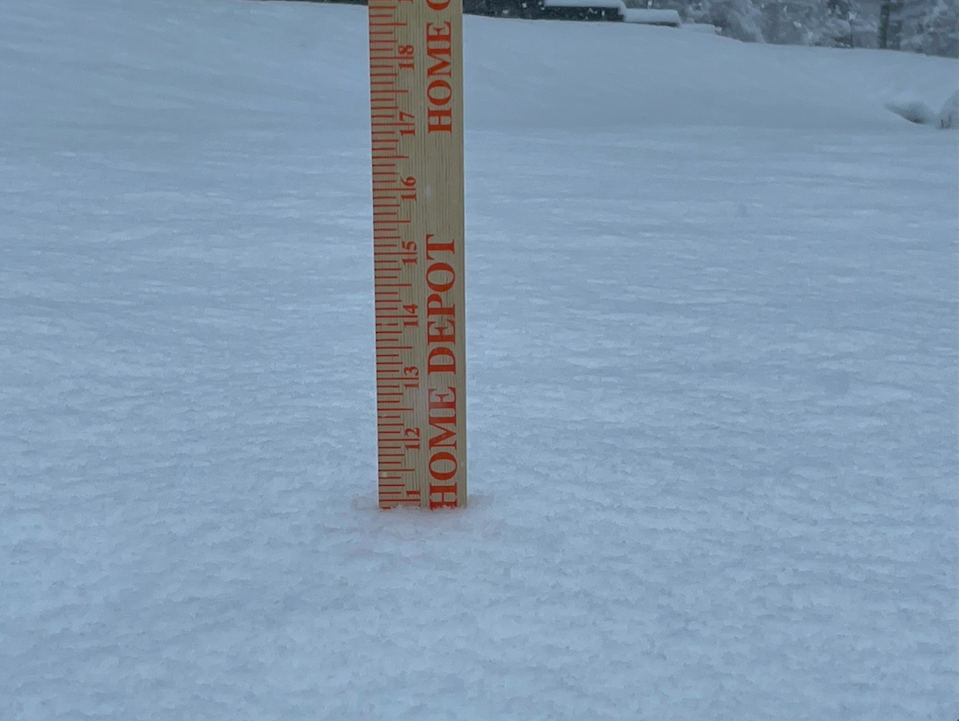
29° w/ Heavy Snow
11.2" otg
( Picked up 6" in 3 hrs )
-
6
-
-
Snowing even harder now lol..
15"+ is def a legit possibility in these parts
-
4
-
-
Should be over a foot within the next hour. What a fail by every single computer model
10.2" otg
-
1
-
-
29° w/ Heavy Snow
10.2" otg
Middletown NY
-
5
-
ECLIPSE CHASING!!!!
in New York City Metro
Posted
The real question is.. how many coats will you be wearing