

OceanStWx
-
Posts
19,758 -
Joined
-
Last visited
Content Type
Profiles
Blogs
Forums
American Weather
Media Demo
Store
Gallery
Posts posted by OceanStWx
-
-
As someone who has never experienced totality, I'm sure it looks the same way just before totality arrives, but seeing the eclipse shadow pass JUST to our north was pretty cool in its own right.
We took the kids out of school and drove as far north as my in-laws (99.12%), but we weren't about to trap ourselves in the car with them in the traffic to the north. Dark enough to see Venus and Jupiter, the kids got a kick out of it.
-
 2
2
-
-
2 minutes ago, dendrite said:
Early feel map
Who started early on happy hour near AFN?
-
9 minutes ago, CoastalWx said:
Ryan in WEHA didn't feel it either. Weird some did some did not.
Was he just coming home from last night?
-
 1
1
-
-
1 minute ago, weatherwiz said:
The magnitude estimates are all over the palce right now...
I'll stick with what USGS goes with. They will revise as they get more data too.
-
1
-
-
1 minute ago, tamarack said:
Much different character, too. Dry cold pow with temps one might expect in a January blizzard - numerous low max records were set. Down at NYC it was the most wintry April snowstorm in their 155-year POR. (Embarrassing for the mets at CAR as well. Like almost everyone, they expected a sharp right turn OTS and were forecasting cold/windy/flurries. Instead, they got 26.3", at the time their biggest on record.)
At that time WSO CON forecast for all of NH, WSO PWM had everything south of a Jackman to Danforth line, and WSO CAR had the rest.
-
1
-
-
2 minutes ago, dryslot said:
I just submitted my report online, Tried calling last night and again this morning, Not surprised you have no phones, Thers carnage everywhere.
Yeah, we're down hard here. It's been the easiest morning after a snowstorm I've ever had.

-
1
-
-
7 minutes ago, Ginx snewx said:
Somebody do some research but maybe biggest overall geographically April snowstorm in NNE recorded history?


1982 wasn't bad. Little lighter for BTV, much bigger for SNE.
-
1
-
-
4 minutes ago, Ginx snewx said:
Hate to do this but the whole setup was so so familiar to me I didn't understand the angst about after 12 Z. But great job
I just wasn't convinced the dry slot would saturate as well as it did. Models started getting a better handle of it 00z the night before for at least a few hours of deformation banding, but when that DGZ is dry I get worried about forecasting big totals. I think we did a really good job of keeping the QPF but knocking the ratios way down so we didn't have some obscene widespread 24+ forecast sneak out the door.
-
2
-
-
2 minutes ago, tunafish said:
You know, that almost gets me to the Gorham line. I could do that.
The differences can be stark, in any direction, across town, for sure. I do worry sometimes about continuity of records given my location compared to the previous observer. But I think if you were to compare my CoCoRaHS observations from 2018-2021, I'd be pretty close to the official obs (at least statistically).
Once in a while there'll be a season (or big event) where the difference is statistically significant, and that stinks, but what can you do?
The reality is that the previous observer was probably equally far from PWM, just on the cold side. I haven't been down to the peninsula today, but I'm guessing they have less snow downtown that I do.
-
1
-
-
4 minutes ago, CoastalWx said:
I thought you guys did a good job. I was wondering about 10" at MHT, but looks like it will be near that? I think yesterday's and lasts night snow helped...I had my doubts about the snow yesterday and last night. Very difficult storm, but when you advect cold from the ENE....it's a unique setup for sure.
I was having a real hard time buying an additional 6" after 12z for a lot of locations yesterday, but it is looking like it is going be pretty widespread.
-
2
-
-
Just now, wx2fish said:
My cousin lives in MHT and said another 2-3" last night after 18z. Hes a few miles north of the airport with a little more elevation but said atleast 8" otg
WMUR also reporting 9.5 storm total.
-
3 minutes ago, HoarfrostHubb said:
I saw Portland had an official Blizzard?
Nah. It's a pretty common mistake that I make all the time. I think Charlie found 3 consecutive obs of blizzard conditions (if you forego the "less than" 1/4 mile bit). But 3 consecutive obs is actually only 2 hours of time. You need 3 hours, so it's really 4 consecutive obs.
-
3
-
-
1 minute ago, tunafish said:
And give up my obs duties? Never!
But seriously this is a deep, internal conflict I have. I LOVE doing the obs, but I hate that I'm 10-15 miles away from a much better weenie spot.
Just stay within 5 miles or so of the Jetport.

It is amazing the difference across town. The previous observer was in North Deering (not far from where I am).
-
2
-
-
2 minutes ago, Ginx snewx said:
Chris already told you it was an estimate. Stop breaking ball's
We couldn't reach them at 18z, but the METAR had a 6 inch snow depth. Based on their previous report we estimated 4.4" additional snow to reach that 6" depth. It could be 5.5" depth rounded up, so maybe you could take that down to 3.9", but it's still a snowfall of 5.5" plus whatever fell after 18z.
-
1
-
-
6 minutes ago, jbenedet said:
Bad forecasts need bad measurements.

Listen, no snow forecast is ever going to be perfect in all locations, but this is going to be a pretty great forecast for a difficult April storm. We'll see what the map looks like later today (though our phones are down, so we may have to delay until we can talk to all the Coops, etc), but I think it's going to look pretty good compared to even our Tuesday maps.
-
3
-
 1
1
-
-
6 minutes ago, tunafish said:
PWM obs
00z - 0.7"
nada at 05z
12z - 0.4"
Event total is 8.0" which includes a total of 2.80" liquid - both rain and snow. Depth is 5"
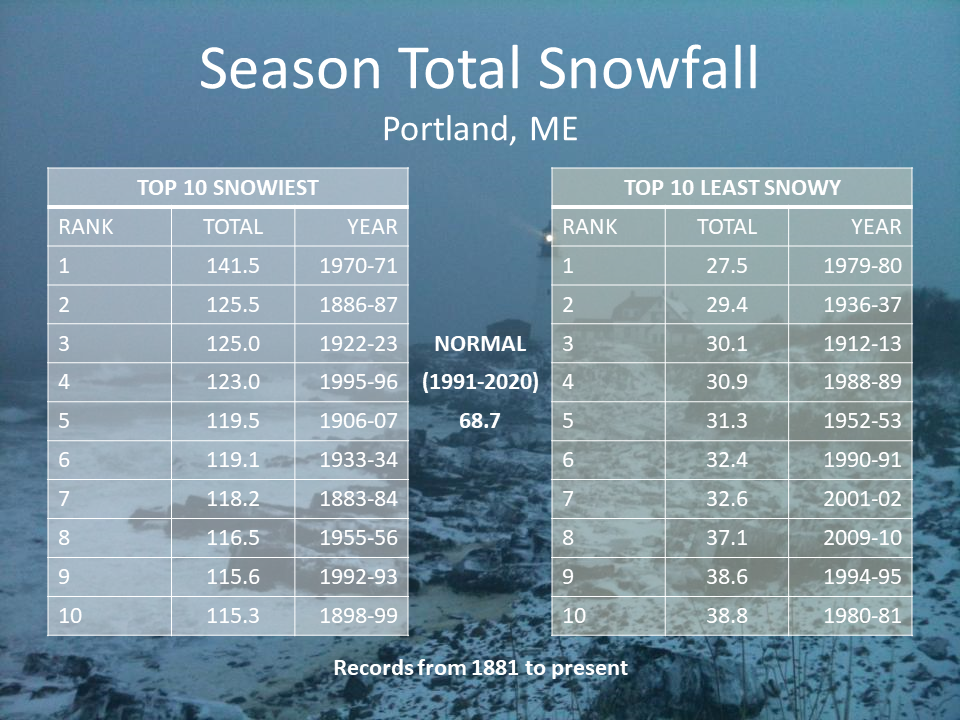
Season total is 38.0". That's going to put PWM #9 on the least snowy winter on record list. Impressive considering 2 weeks ago we were post equinox and sitting at #1.
It's still snowing lightly but I don't think we're picking up another 0.6", which would bump us from #9 to #10.
Time to move.
")
I'm over 50" for the season now on the northern outskirts of PWM.
-
2
-
-
2 minutes ago, CoastalWx said:
Sounds like the Pope parted the snow to make up 2”?

-
5
-
-
5 minutes ago, Lava Rock said:
Wonder where we'd be if the Dec and Jan rn storms were all sn. We'd be pushing 120" I'd think.
Even if you just made those months average (and March was below too) I would be near 80" for MBY. That's a solid +20 for the PWM area.
-
2
-
-
3 minutes ago, CoastalWx said:
6-8” there on PNS.
I know the phones were out for the observer there, so we had trouble getting a total. We were estimating 6 inches at 18z yesterday.
-
4 minutes ago, MaineJayhawk said:
In the neighborhood of 18-19". Power out, no cell service, all sorts of trees entangled in power lines in my neighborhood, the power line to my house is laying in the road .. this will be a long-duration outage and as it's the weekend we will get a hotel room til Monday.
This was a real man storm up here. None of the typical spring garbage where downsloping or elevations plays havoc with the totals. It's going to be a fairly uniform 10-20" for most of our CWA, outside of the areas that struggled to flip to snow at the onset.
-
1
-
-
Genny still running. Another 0.2" overnight brings me to 11.5".
That's a 6:1 ratio for a nearly foot snowfall. One of the densest snowstorms I can remember.
-
5
-
-
East Sandwich Coop with 18.5"
-
4
-
-
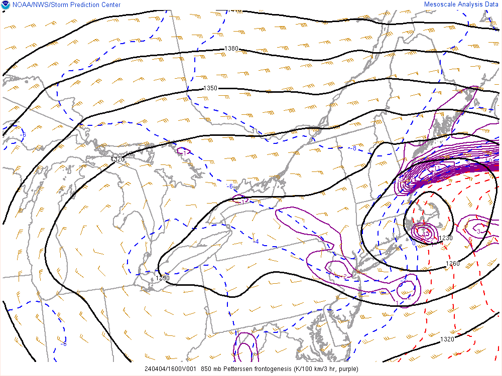
2 minutes ago, CoastalWx said:
That area was pegged on a lot of guidance for sure. Just consistent mesoscale banding. Wasn’t really buying 18-24 but may just happen in a narrow area. Kind of a last minute H7 redevelopment there helping out locally.
You can see the circulation now over the Monadnocks on the LL WV product. That peaks around 620 mb, so the H7 low is probably a little south of that. Ekster doing naked snow angels through dinner time.
-
2
-
-
10 minutes ago, Ginx snewx said:
Man some potential though
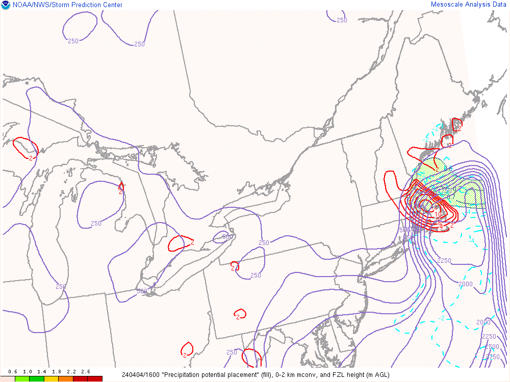
There's big H8 convergence forecast through the afternoon. That's a little low for a DGZ fluff bomb, but the upper levels are cooling and some slightly warmer temps should be satisfactory for 10:1 ratios for a time.
-
2
-

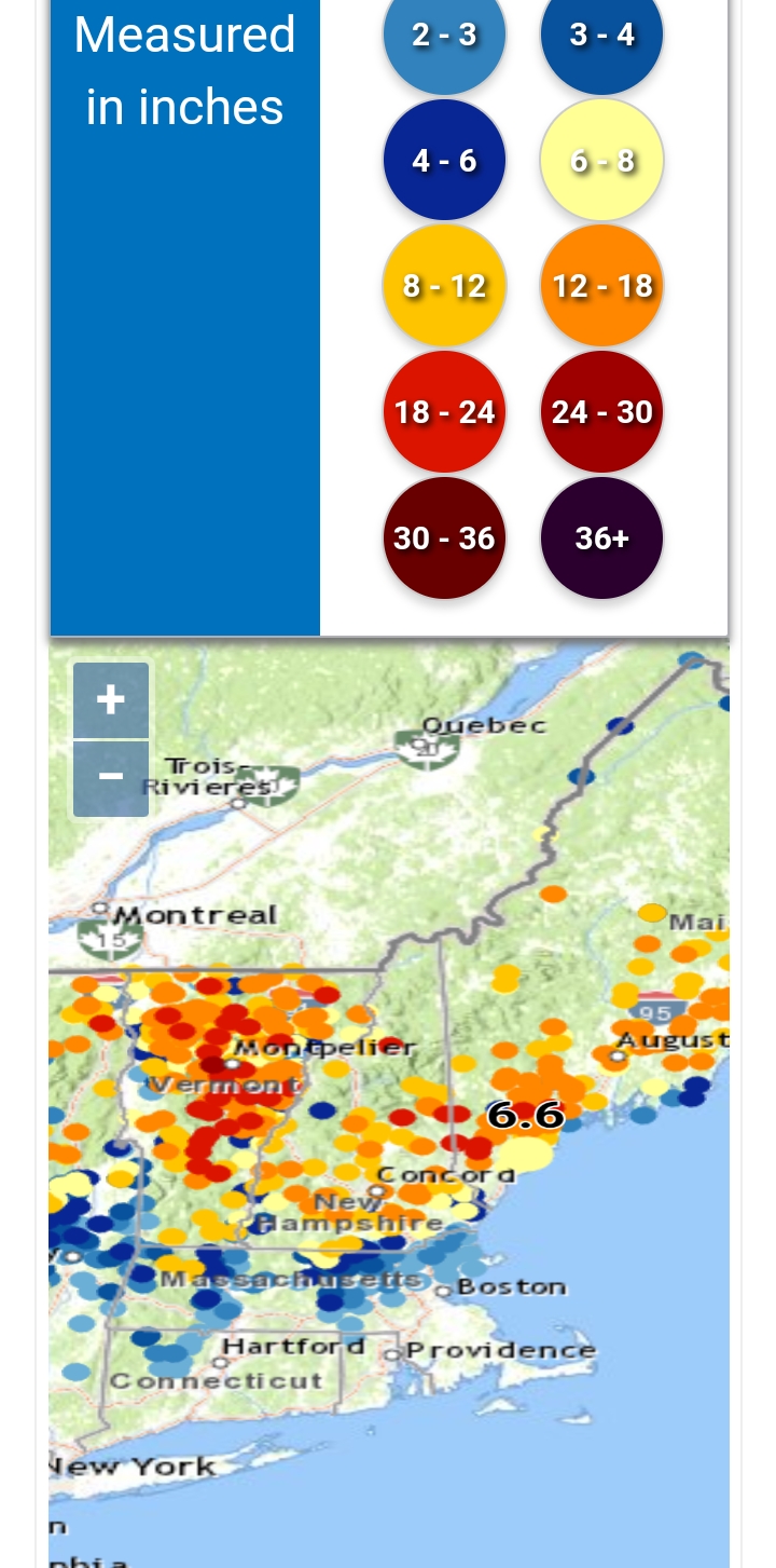
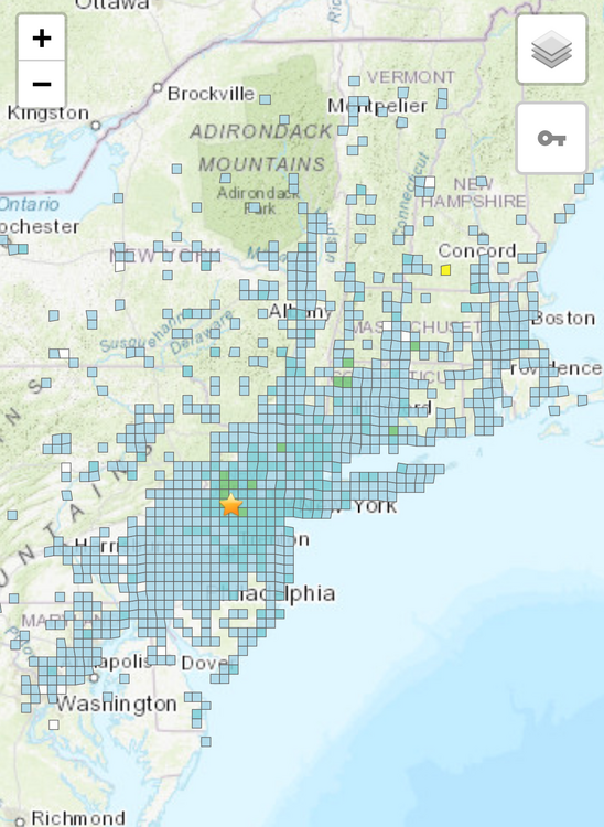
April 2024 Disco- SNE’s favorite month
in New England
Posted
Two feet after the equinox to claw my way to normal snowfall. Just how you draw it up in the pre-winter meetings.