

Sn0waddict
-
Posts
4,685 -
Joined
-
Last visited
Content Type
Profiles
Blogs
Forums
American Weather
Media Demo
Store
Gallery
Posts posted by Sn0waddict
-
-
NWS Upton:
&&

.SHORT TERM /WEDNESDAY THROUGH WEDNESDAY NIGHT/...
The region is in the warm sector of this system on Wednesday
ahead of the incoming trough and cold frontal passage late
Wednesday evening and night. A tightening pressure gradient at
the surface and a strengthening LLJ, progged around 65 to 75 kt
at 925 mb Wednesday afternoon will lead to gusty conditions at
the surface. Soundings continue to indicate a strong inversion
that should cut down the strength of these gusts at the surface,
but likely still allow gusts to exceed 35 kt, especially as the
cold front advances east. Wind Advisory is possible at least
for eastern coastal areas, but still some time left to fine tune
this. Rain showers will be ongoing Wednesday morning and likely
continue intermittently through the day, although a complete
washout is not expected.
-
Got to appreciate how much nicer 40F full sun and no wind feels this time of year va December.
-
February :
-
 2
2
-
 1
1
-
 1
1
-
-
Last band pushing through now, will be done in 20 mins

-
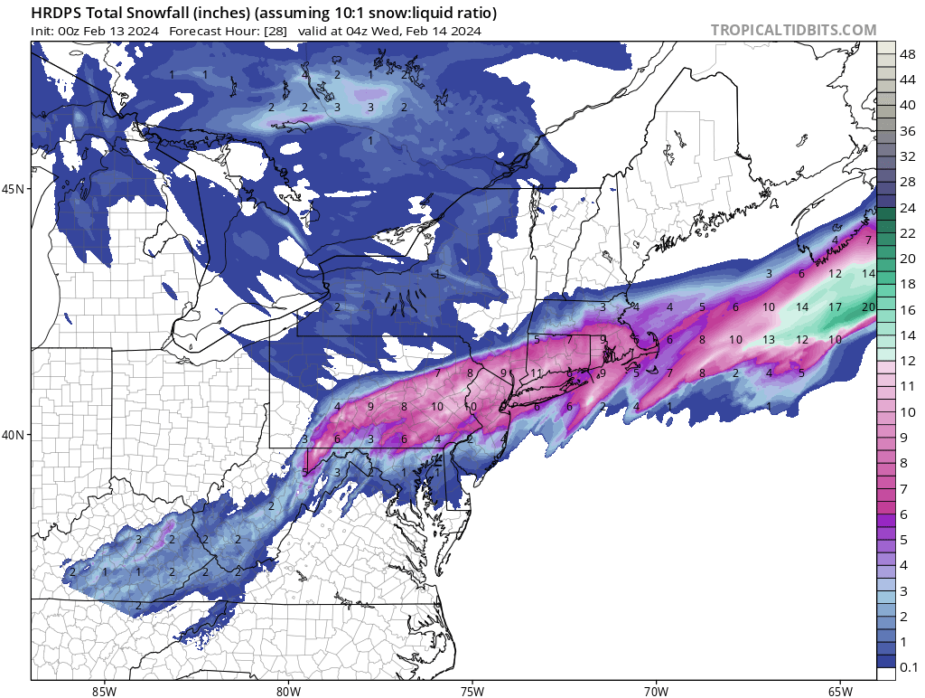
Curious about the amount of QPF Hartford got in correlation with their 15 inches.
-
1
-
-
19 minutes ago, CT Rain said:
15.2" in West Hartford here at the station. Nuts.
My god. Inland always finds a way to win out!
-
2 minutes ago, jbenedet said:
Rural CT only snowstorms are the worst. All the villageidiots posting snow pics like their backyard is happening everywhere.
Pretty sure there's a local brainworm problem in "drive thru" country of New England.
Impacts are being felt down to the coast, which certainly isn’t “rural” New England
-
2
-
-
1 minute ago, TalcottWx said:
Mid-level frontogenesis & also convergence early on that's been aided by the low deepening and now maturing. That area has been ideal for a variety of factors, including being further away from the ocean. Most of the battle is snow growth I feel a lot of the time.
No kidding! Good for them.
-
How the hell does Hartford have 11 inches lol that’s crazy. 5 inches here but coming down at least an inch an hour.
-
Absolute whiteout right now.
-
1
-
-
Time for bed, but hey the HERPES model still looks good!

-
 1
1
-
-
3 minutes ago, WinterWolf said:
The better question is…can you believe it?
Who knows at this point lol
-
1
-
-
Gfs is pretty damn good on the south coast.
-
2
-
-
I checked the SREF plumes for KBDR for the hell of it and they actually look like they got better. Some real high end members in there as well. If only those damn things were remotely good.
-
3 minutes ago, CT Rain said:
Yup... HRRR looks worse. Blahh.
Ya that’s a cut back in precip. Not even that impressive down here.
-
1 minute ago, ineedsnow said:
22z HRRR looks to be bumping north a tad but not sure its enough for anything meaningful
Ya I kinda think the same looking at it.
-
1 minute ago, NorEastermass128 said:
This hobby blows sometimes.
Sometimes?
-
1
-
-
2 minutes ago, Brian5671 said:
Amazing-can't win this year
Gotta pray that the models are “over correcting” and will come back north a bit. Seen it before, but not so sure I’ve seen that within 24 hours of said storm.
-
Just now, Prismshine Productions said:
Jfc


Sent from my SM-S146VL using Tapatalk
I said don’t do that! Lol
-
2
-
-
Shield your eyes from the 3k NAM. And especially don’t look at the snowfall difference between the 18z run and 12z
-
1 minute ago, Prismshine Productions said:
NAM trends south, UKIE scored the coop
Sent from my SM-S146VL using Tapatalk
CMC was suppressed since the beginning as well.
-
2
-
-
This is probably my fault. I just went out to get gas for the snowblower, and I come back to see the EURO/EPS. Woof.
-
2
-
-
Huh that was quite the trend down here tonight. If it stays like this past 12z then I’m sold.
-
2 minutes ago, NEPASnow said:
Thanks, my bad as well. The other sub forums on american are kinda lame
Most of this board comes from easternuswx, which as the name suggests focused on the major eastern cities.
-
2
-
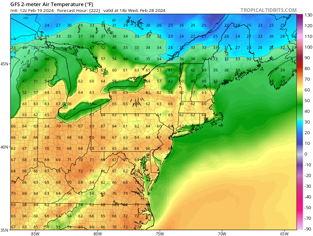
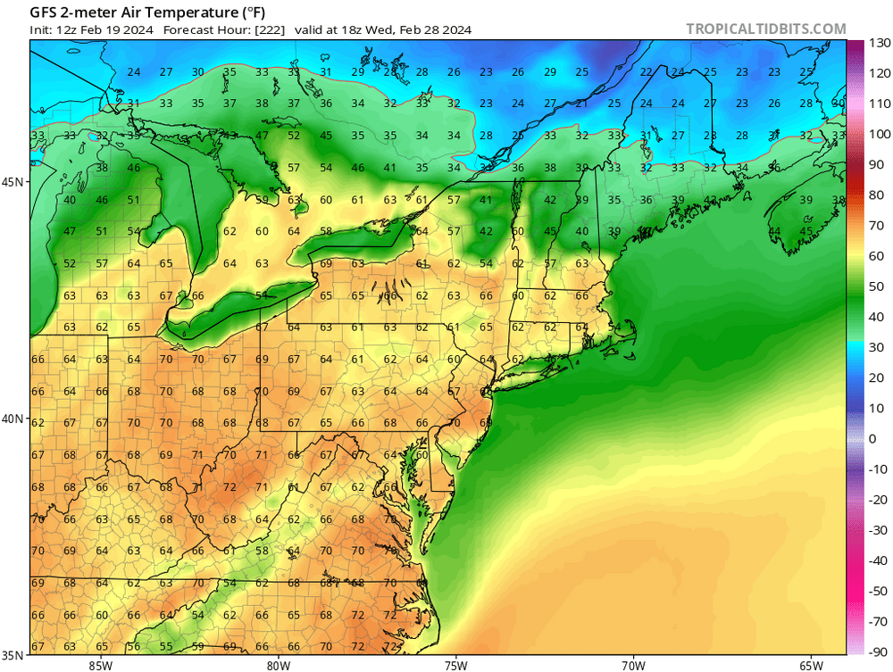
Wednesday, February 28, 2024 Mild temperatures ahead of a Strong Arctic Cold Front with a Line of Rain and Thunderstorms Associated by Big Bad Wolf howling winds knocking down forests followed by Brief, but chilly Arctic Cold
in New England
Posted