

OSUmetstud
-
Posts
16,433 -
Joined
-
Last visited
Content Type
Profiles
Blogs
Forums
American Weather
Media Demo
Store
Gallery
Posts posted by OSUmetstud
-
-
Just now, WxWatcher007 said:
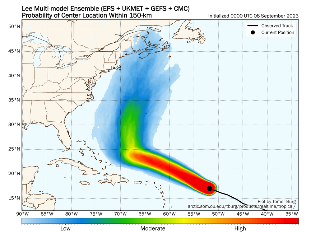
The shift in medium range guidance there was one of the most extreme shifts I’ve ever seen for tropical.
Tough when the ensemble suite stretches from Bermuda to central Newfoundland for the same forecast hour. The spread at range for Lee is less than climo per Tomer Burg's products.
-
 4
4
-
-
Just now, WxWatcher007 said:
At this range I agree about Atlantic Canada, though plenty of time for shifts a la Franklin.
Yeah for sure. I was pretty convinced Franklin was coming, then it all changed lol.
-
Overnight stuff looks less favorable than it did yesterday to me for a US landfall. While you might think that some of the westward bends on the ensemble tracks are helpful, they also delay latitude gain as the northeast trough wants to pull out. Atlantic Canada is still very much in play, obviously. Probably <~5% now.
-
2
-
-
If you can get Lee inside 70W the whole dynamic changes imo. Last night's runs, especially the ECMWF had a very favorable trough/ridge combo for US landfall. It's just that storm is out between 65 and 70W so it ends up being a Nova Scotia thing. Lee kinda sits in no man's land for a few days north of the Greater Antilles without a strong Bermuda high to push it west. I'd probably put a northeast landfall at 10%, with 50% Atlantic Canada, and 40% out to sea.
-
2
-
-
Some of the Cat 5 landfall talk seems pretty silly. It may have been a cat 5 a few hours west of landfall in the western eyewall, but there was no evidence of it being a cat 5 at landfall that I saw. Michael actually had near 140 kt SFMR near landfall. At least one of the reasons they didn't upgrade operationally for Michael was that the SFMR does have a high bias in shallow water.
-
4
-
 1
1
-
-
The pressure has fallen. Come on lol.
-
I disagree on this being a predecessor rainfall event. That's not a distinct area of rainfall separated from the TC. The radar rainfall is continuous and Miami is fairly close to Ian.
PREs are coherent mesoscale regions of heavy rainfall, with rainfall rates ≥100 mm (24 h)−1, that can occur approximately 1000 km poleward of recurving tropical cyclones (TCs). PREs occur most commonly in August and September, and approximately 36 h prior to the arrival of the main rain shield associated with the TC.
-
7
-
 1
1
-
-
From what I can gather, the main sources of track error are:
Stronger hurricane likely gets a bit further south and west.
The northeast trough. Does it dig far enough southwest to drag Ian northward or does Ian miss and meander in the GOM for a few days and weaken under shear?
-
1
-
-
NHC will typically follow TVCN quite close, which is a corrected consensus blend. Until this shifts west I wouldn't expect much in the way of changes with the cone. It was the best scoring track "model" last year at nearly all lead times.
.png.c3456aecfeea495a035c0061e397ed1b.png)
-
9
-
-
2 minutes ago, 40/70 Benchmark said:
GFS has closed the cap, to a degree, on the EURO IMHO.
I don't like it too much up here overall, but it's an excellent tropical model nowadays.
-
Also, while the ECMWF does have overall superior forecasting metrics, the GFS had a lower MAE for Atlantic storms last year than the ECMWF did.
-
3
-
-
The ensembles are great, but the mean actually has a larger track MAE than the operational model. For example, the GFS ensemble had 20 NM greater error than the GFS at 120 hours in the 2021 NHC verification report. They're a tool to see different solutions, model spreads, and sensitivities to the overall weather pattern.
-
1
-
-
6 minutes ago, Eskimo Joe said:
I think initial runs of the GFS were obviously too deep in the short term which caused the storm track more toward the Loop current as opposed to over western Cuba. Now that the storm is actually deepening, the ECMWF has been too weak and slow to come around.
-
ECMWF is way too far west to maximize storm surge for western Florida. The peninsula is only in minimal TS winds with that track.
-
2
-
-
48 minutes ago, Dan76 said:
St Johns I believe
Yes I'm too far for significant impacts from the looks of things
-
1
-
-
Uncle's not bad, looks a bit better to me actually.
-
38 minutes ago, ORH_wxman said:
Thanks that’s close but I was looking for the site that produces these images:
https://www.emc.ncep.noaa.gov/gmb/STATS_vsdb/
GFS trash lately.
-
1
-
-
10 minutes ago, BuffaloWeather said:
Does anyone know if thundersnow occurred overnight around Buffalo or just Niagara Falls, approximate timestamp?
There was a lot of strikes near Welland early this morning with the superband, none on BUF/IAG side that I saw.
-
 2
2
-
-
Highest report I can find so far is 17.3" in Kenmore 0.3 ESE Cocorahs.
-
8 minutes ago, rochesterdave said:
Is it a digital system? Because the airport was under heavy sleet/snow returns for several hours 1am-5am.
It was, but it doesn't agree with the Cocorahs gauges this morning. There was an hourly report of almost 1" of liquid.
-
6 minutes ago, tim123 said:
This should be interesting. Roc reported 2 inches of liquid. Wonder how much is snow.
I'm calling bs on the precip amounts being reported there.
-
1
-
 2
2
-
-
Pretty convinced the niagara escarpment will end up the winner overall. The banding there lingers longer than anywhere else.
-
2
-
-
15" at BUF as of the latest metar, probably make a run for 20.
-
1
-
1
-
-


Category Five Hurricane Lee
in Tropical Headquarters
Posted
Westward short term adjustments to Lee don't increase US landfall probabilities much if it at all because they also delay latitude gain with the Great Lakes trough trending eastward and having a tendency to pull out of the northeast with time.