
ChescoWx
-
Posts
7,410 -
Joined
-
Last visited
Content Type
Profiles
Blogs
Forums
American Weather
Media Demo
Store
Gallery
Posts posted by ChescoWx
-
-
1 minute ago, Atomixwx said:
Right. Tornado may drop on somebody today, but great weather coming, this.
Sent from my motorola edge 5G UW (2021) using Tapatalk
Threat for any damaging or tornadic stronger storms will be near to north of I-80. The modeled line clearly weakens as it moves SE between I-80 and I-78. South of I-78 here in Chester County the storms or what's left of them will be showers at most.
-
8 hours ago, donsutherland1 said:
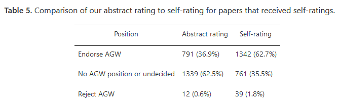
There's more to the story. When the authors of the papers that expressed no view in the abstract regarding AGW were asked to self-rate their positions, more than 60% endorsed AGW. Rejection of AGW languished at 1.8%. In short, very few scientists actually reject AGW. The majority endorse it.
https://iopscience.iop.org/article/10.1088/1748-9326/8/2/024024
Those numbers sure don't sound like consensus.....majority is far far from consensus!
"Consensus is invoked only in situations where the science is not solid enough. Nobody says the consensus is the sun is 93 million miles away. It would never occur to anyone to speak that way"Michael Crichton
-
Some great weather over the next few days although with the winds today might be a bit tough on some allergy sufferers. Looks like shower chances return by Wednesday and could last through the rest of the week! Our wet year continues!Chester County Records for today: High 91 degrees Phoenixville (1941) / Low 21 degrees West Chester (1940) / Rain 2.28" Coatesville (1970) / Snow 2.5" Coatesville (1923)
-
The fake news that the "science is settled" or the equally fake "90%+ consensus of scientists agree” from Lynas et al. (2021) was accomplished by pure selective math. To get that 90% plus "consensus" required dismissing over 68% of the studies reviewed. The real numbers paint a different story. Of the total 2,718 randomly-selected papers examined 1,869 (68.8%) expressed no position on human-caused climate change. However there were 849 of them did, and 845 indeed endorsed it. The 90%+ math comes from dividing 845 by 849, and ignoring the 1,869 other scientific studies that expressed absolutely no opinion. The true math actually comes out to closer to 30% ....30% is of course quite far from consensus.
-
 1
1
-
-
0.24" of rain so far since yesterday here in East Nantmeal. Might see another 0.25" or more if any thunderstorms pop up. Shower chances finally go away by Saturday PM and after a chilly Saturday we should see a nice warming trend get underway by Sunday and carry us into next week.Chester County records for today: High 90 degrees Devault (1977) / Low 18 degrees Phoenixville (1921) / Rain 2.29" Kennett Square (1913) / Snow 3.0" Devault (1959)

-
 1
1
-
-
0.24" of rain so far since yesterday here in East Nantmeal. Might see another 0.25" or more if any thunderstorms pop up. Shower chances finally go away by Saturday PM and after a chilly Saturday we should see a nice warming trend get underway by Sunday and carry us into next week.Chester County records for today: High 90 degrees Devault (1977) / Low 18 degrees Phoenixville (1921) / Rain 2.29" Kennett Square (1913) / Snow 3.0" Devault (1959)
-
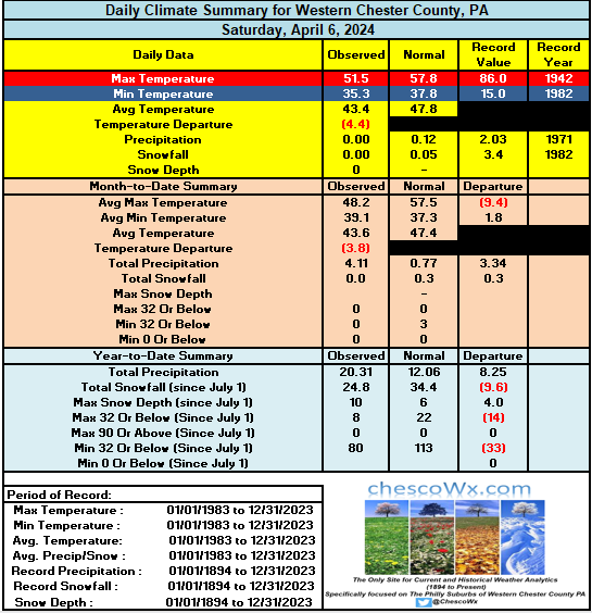
Clouds and showers to close out the work week with the heaviest rain likely overnight tonight. Sun returns and cooler on Saturday before a nice warm up with temps into the mid 70's for the county next week. Longer term a return to below normal temps looks increasingly likely as we move into next weekend and toward the end of the month.County records for today: High 89 West Chester (2013) / Low 20 Phoenixville (1921) / Rain 2.06" West Grove (1929) / Snow 18.5" Coatesville (1894)
-
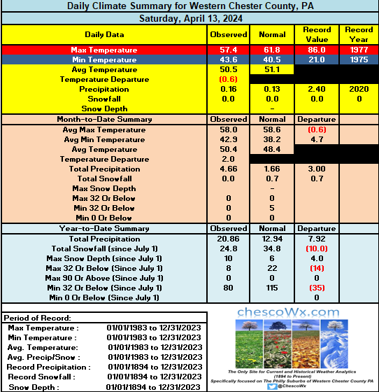
Mild again today but we look cloudy with increasing shower chances for the rest of the work week before we clear out for the weekend. Some models paint another 1" to 2" of rain by late Friday.Chester County records for today: High 88.9 at Nottingham (2013) / Low 15 Devault (1958) / Rain 2.05: Coatesville (1993) / Snow 9.7" (1894). Of note this snow was the start of a 2 day snowstorm that was the largest snowstorm in April history across Central PA and Chester County with 29" of snow falling at Coatesville..The NWS PHL historical weather page details this April storm as follows.1894...(April 10-12) Md-DC-DE-PA-NJ-NY. Whirling snowstorm and gale winds,remarkable so late in Spring. Most severe for many years in MD, DE and DC with snow 20 to 24" deep; 12 to 31" in PA; 5 to 21" in NJ; and 6 to 30" in NY. Roads blocked."

-
2
-
-
Mild again today but we look cloudy with increasing shower chances for the rest of the work week before we clear out for the weekend. Some models paint another 1" to 2" of rain by late Friday.Chester County records for today: High 88.9 at Nottingham (2013) / Low 15 Devault (1958) / Rain 2.05: Coatesville (1993) / Snow 9.7" (1894). Of note this snow was the start of a 2 day snowstorm that was the largest snowstorm in April history with 29" of snow falling at Coatesville..The NWS PHL historical weather page details this April storm as follows.1894...(April 10-12) Md-DC-DE-PA-NJ-NY. Whirling snowstorm and gale winds,remarkable so late in Spring. Most severe for many years in MD, DE and DC with snow 20 to 24" deep; 12 to 31" in PA; 5 to 21" in NJ; and 6 to 30" in NY. Roads blocked."
-
Today was the warmest day across Chester County since last October 28th. Some high temps across the area included as high as 79.7 at West Chester/ 78.9 at Warwick/ Nottingham and Devault / 76.1 at Atgen / 77.4 at Glenmoore / 77.3 at East Nantmeal and 77.0 at KMQS airport in Coatesville
-
Today could be our warmest day so far this year - our warmest reading so far was the 74.1 back on March 14th. After today the weather looks a bit unsettled with shower chances through Friday (we could see near another inch or rain in some spots) with the greatest likelihood coming on Thursday. Sun returns this weekend!Chester County records for today: High 89 degrees Phoenixville (1959) / Low 20 degrees Devault (1977) / Rain 2.32" Kennett Square (1906) / Snow 6.0" West Chester (1917)
-
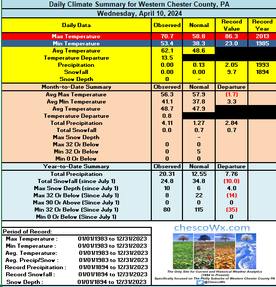
Across much of the county we are off to the chilliest start to April since 2013. 17 of our last 21 days have been colder than normal. Today should be the last below normal day with the warmest day coming Tuesday with highs in the low 70's. Tomorrow is forecast to be mostly sunny for eclipse viewing however it looks like we may start to see some increasing clouds that could mute viewing (with appropriate eye wear) Shower chances increase again from Tuesday night through Friday.County wide records for today: High 92 degrees Phoenixville (1929) / Low 14 degrees West Chester (1982) / Rain 2.00" Marshallton (2022) / Snow 5.0" Kennett Square (1916)
-
1 hour ago, chubbs said:
I have no problem going back before 1960. I'll go way back, but I'm not going to limit myself to a small slice of biased data. No. I want to look at all the data and use the best methods to analyze it. From the last IPCC report
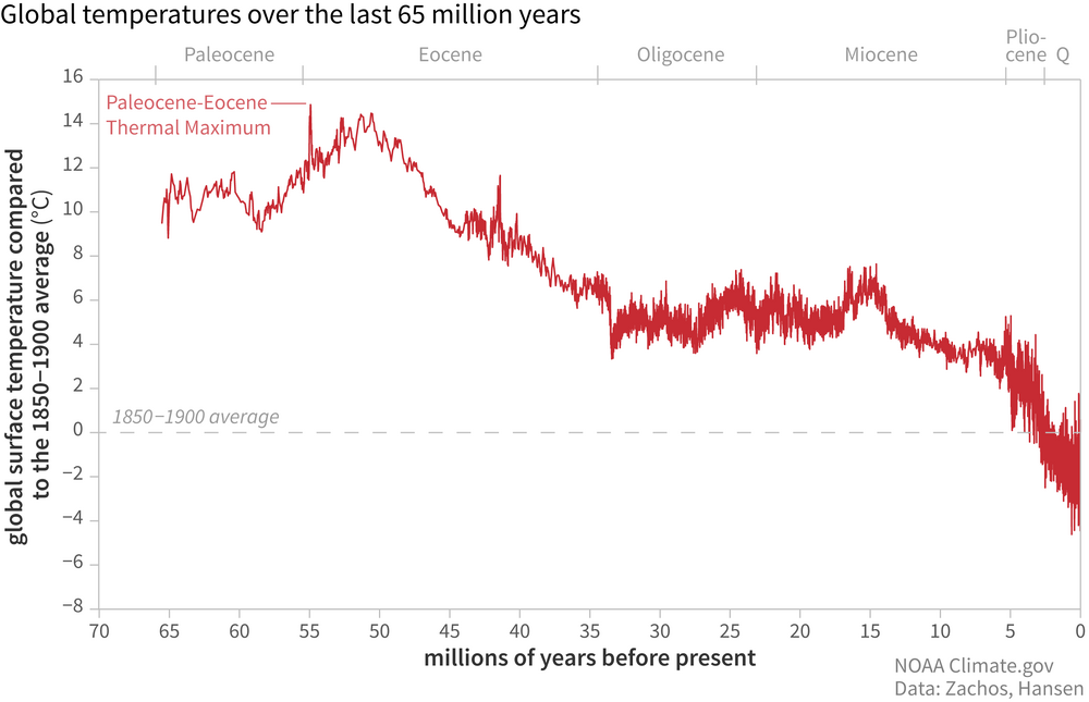
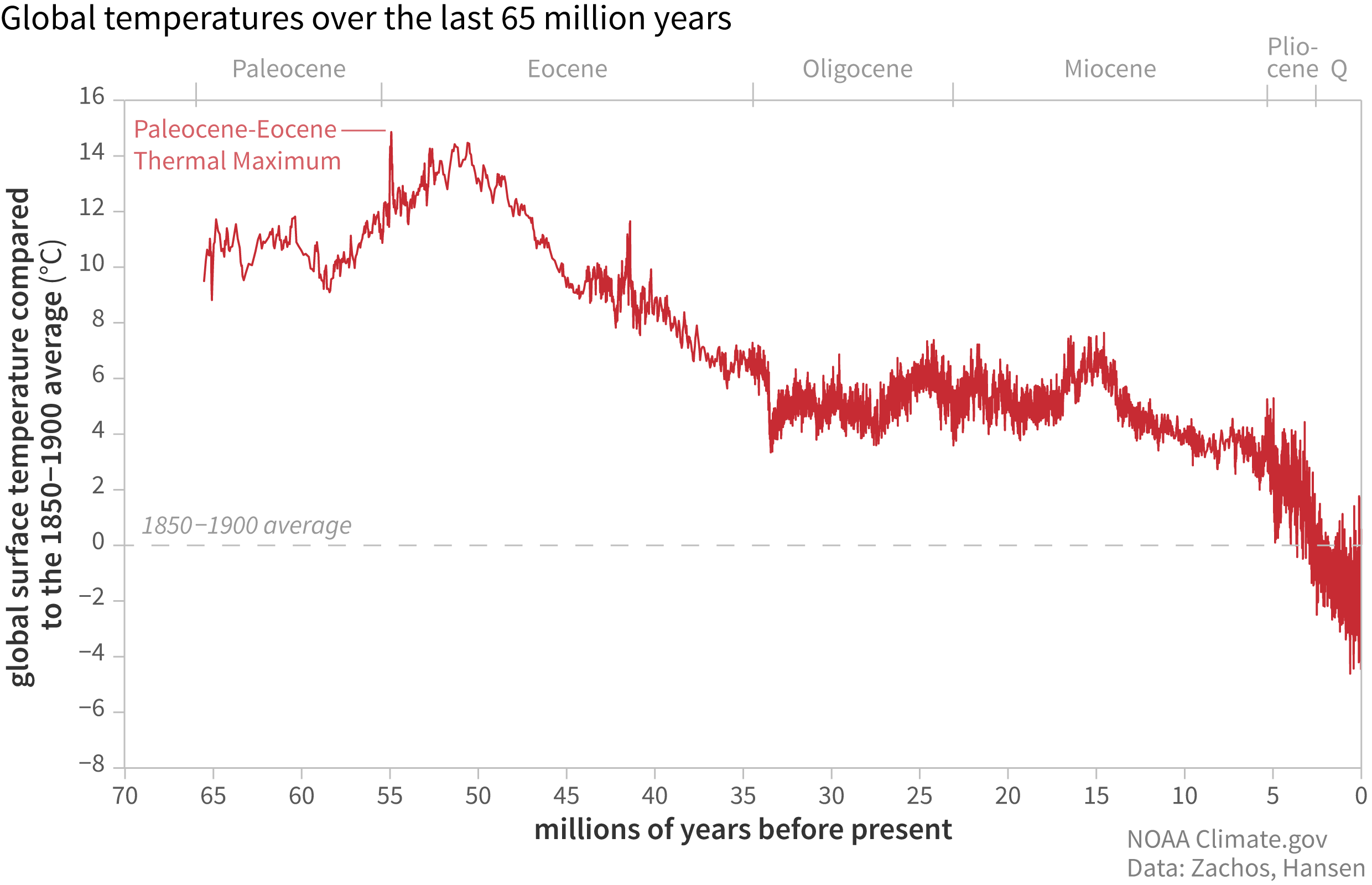
Let's go back even further Charlie! The Earth is essentially at its coolest point in the last 65 million years, but climate alarmist love to tell us the planet is “too hot” because temperatures are 1.2°C warmer than they were in 1850, the tail end of the Little Ice Age!!
-
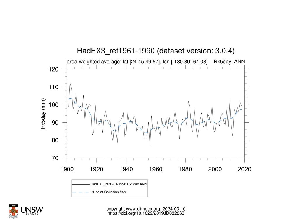
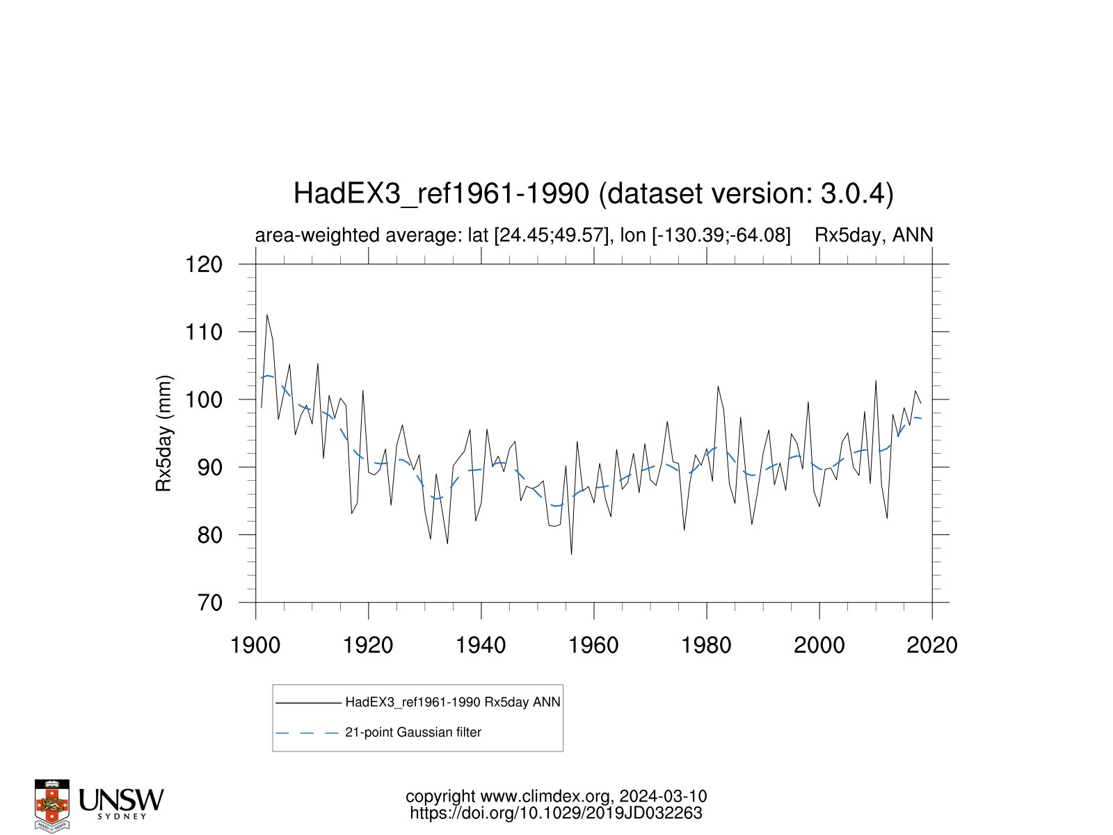
We are told by alarmists that warming of the climate is expected to increase the frequency and intensity of heavy rainfall events. One key measure of this used by climate models is the annual maximum 1 and 5-day maximum precipitation amounts (Rx1day and Rx5day, respectively). The results below indicate that while both the Rx1day and Rx5day have increased across the US since 1960....of course if we choose to go back far enough, rainfall extremes were higher than recent decades between 1901 and 1930 across both measures. Funny how weather history if we go back far enough....shows us all that is happening now has indeed occurred before. No climate emergency at all to see here!
-
12 hours ago, chubbs said:
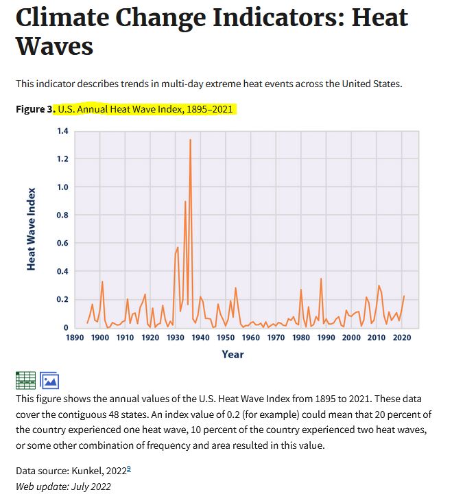
Chesco didn't show us Figure 1 and 2, must have been an oversight.
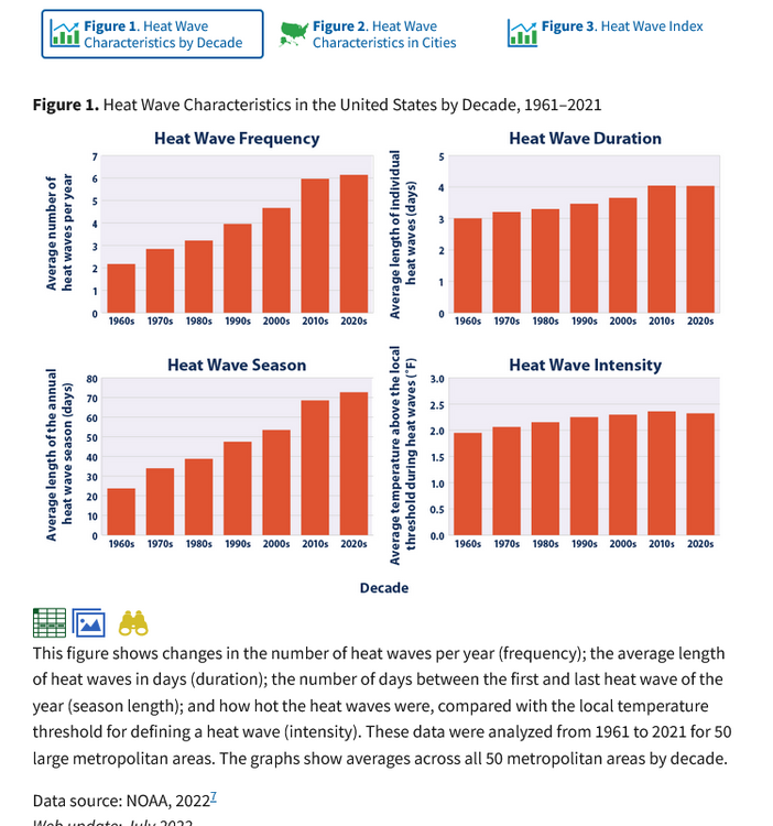
hey Charlie.....there is actually weather data before 1960.....some folks don't like that data - well unless we make some chilling adjustments as it does not support the non-stop warming story. The above charts I added do not omit the older data back in our last warming cycle that you likely forgot to add...
-
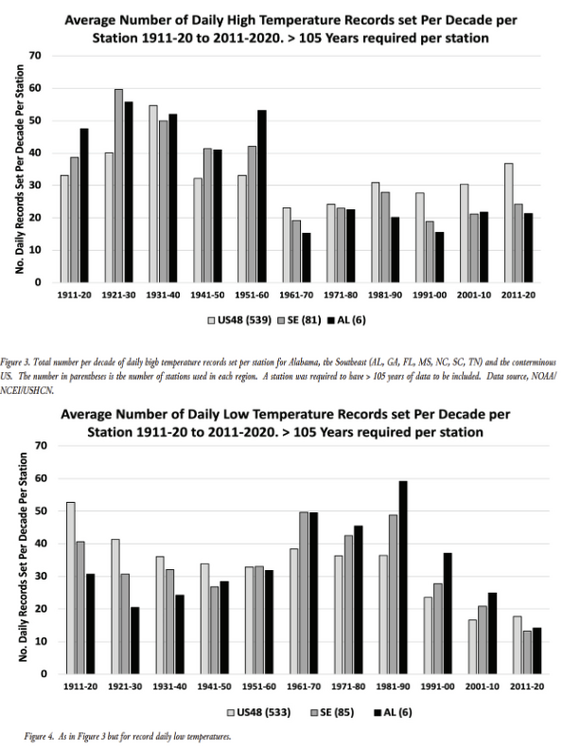
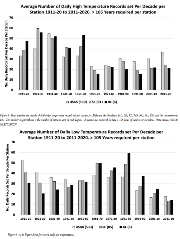
The below with a longer more appropriate time frame than Charlie showed above shows that the actual frequency of daily high temperature records in the U.S. [avg across ~540 GHCN-daily record stations] has actually decreased since 1911. The mean over the last five decades is almost 21% lower than the 1911-1960 average. Cold extremes have decreased too, and rather sharply since the 1980. Again can we say cyclical normal climate change and nothing at all to be alarmed at here??
-
12 hours ago, chubbs said:
This recent study shows that global heat waves are becoming more frequent, lasting longer, covering larger areas, moving slower, and bringing higher temperatures.
https://www.science.org/doi/10.1126/sciadv.adl1598
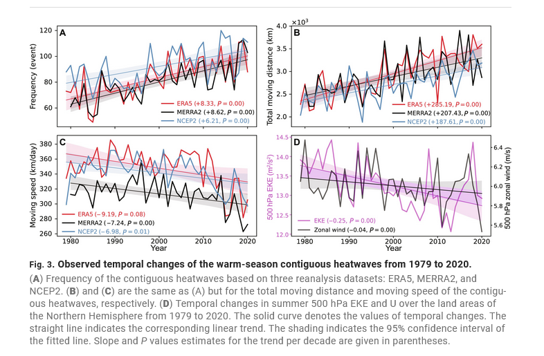
Compounding the effects of high temperature, global dew point and wet bulb temperatures are also rising.
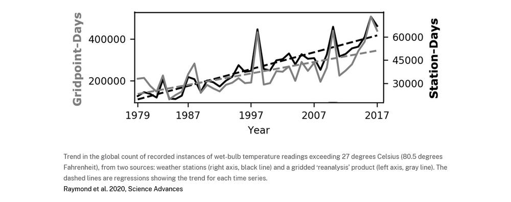
Of course climate did not begin in 1979....perhaps you overlooked that one....
-
Another below normal temperature day...but at least dry across the area. Some areas by early Monday morning could see some readings near the freezing mark. A strong warming trend finally sets in on Monday with the warmest day looking like Tuesday before more showers and rain arrive on Wednesday and last through much of the rest of the work week.Chester County records for today: High temp 90 degrees Phoenixville (2010) / Low 15 Coatesville (1982) / Rain 2.03" Coatesville (1971) / Snow 4.0" Devault 4.0" (1971)
-
1 hour ago, chubbs said:
You can't prove your assertions either. I can provide evidence of climate and weather change, reams of evidence. That's something you are short on..
Then produce some actual real weather data like below. Funny again Charlie that all of that coast to coast heat when it really was hot back in the 1930's and 1940's needed to be adjusted in all of the post hoc after the fact data you always show. So why are we having less heat waves??


Central Pa. Spring 2024
in Upstate New York/Pennsylvania
Posted
Of course but not for the counties in the southern areas of the thread area...my thoughts were clearly all about Chester County PA as I very clearly always state! I am not commenting for those folks further to the West or North of Chesco...and never do. The area covered by this thread is too large and variable to make a blanket statement which I don't.