ChescoWx
-
Posts
7,423 -
Joined
-
Last visited
Content Type
Profiles
Blogs
Forums
American Weather
Media Demo
Store
Gallery
Everything posted by ChescoWx
-

E PA/NJ/DE Spring 2024 OBS/Discussion
ChescoWx replied to Hurricane Agnes's topic in Philadelphia Region
Today was the warmest day across Chester County since last October 28th. Some high temps across the area included as high as 79.7 at West Chester/ 78.9 at Warwick/ Nottingham and Devault / 76.1 at Atgen / 77.4 at Glenmoore / 77.3 at East Nantmeal and 77.0 at KMQS airport in Coatesville -
Today could be our warmest day so far this year - our warmest reading so far was the 74.1 back on March 14th. After today the weather looks a bit unsettled with shower chances through Friday (we could see near another inch or rain in some spots) with the greatest likelihood coming on Thursday. Sun returns this weekend! Chester County records for today: High 89 degrees Phoenixville (1959) / Low 20 degrees Devault (1977) / Rain 2.32" Kennett Square (1906) / Snow 6.0" West Chester (1917)
-
E PA/NJ/DE Spring 2024 OBS/Discussion
ChescoWx replied to Hurricane Agnes's topic in Philadelphia Region
Today could be our warmest day so far this year - our warmest reading so far was the 74.1 back on March 14th. After today the weather looks a bit unsettled with shower chances through Friday (we could see near another inch or rain in some spots) with the greatest likelihood coming on Thursday. Sun returns this weekend! Chester County records for today: High 89 degrees Phoenixville (1959) / Low 20 degrees Devault (1977) / Rain 2.32" Kennett Square (1906) / Snow 6.0" West Chester (1917)
-
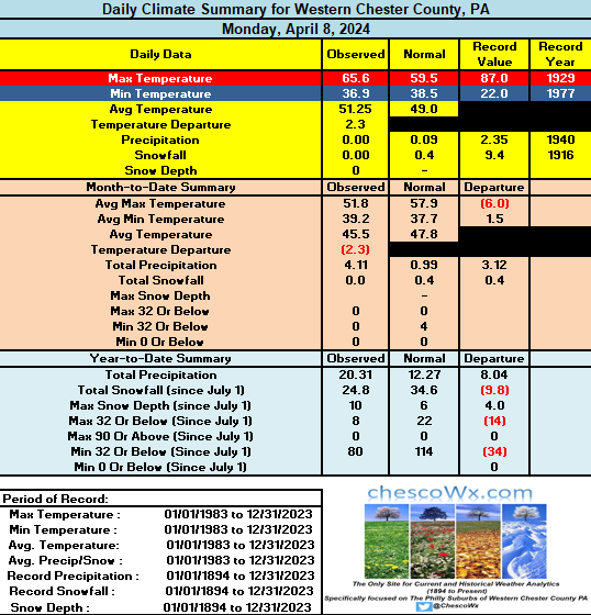
Across much of the county we are off to the chilliest start to April since 2013. 17 of our last 21 days have been colder than normal. Today should be the last below normal day with the warmest day coming Tuesday with highs in the low 70's. Tomorrow is forecast to be mostly sunny for eclipse viewing however it looks like we may start to see some increasing clouds that could mute viewing (with appropriate eye wear) Shower chances increase again from Tuesday night through Friday. County wide records for today: High 92 degrees Phoenixville (1929) / Low 14 degrees West Chester (1982) / Rain 2.00" Marshallton (2022) / Snow 5.0" Kennett Square (1916)
-
E PA/NJ/DE Spring 2024 OBS/Discussion
ChescoWx replied to Hurricane Agnes's topic in Philadelphia Region
Across much of the county we are off to the chilliest start to April since 2013. 17 of our last 21 days have been colder than normal. Today should be the last below normal day with the warmest day coming Tuesday with highs in the low 70's. Tomorrow is forecast to be mostly sunny for eclipse viewing however it looks like we may start to see some increasing clouds that could mute viewing (with appropriate eye wear) Shower chances increase again from Tuesday night through Friday. County wide records for today: High 92 degrees Phoenixville (1929) / Low 14 degrees West Chester (1982) / Rain 2.00" Marshallton (2022) / Snow 5.0" Kennett Square (1916)
-
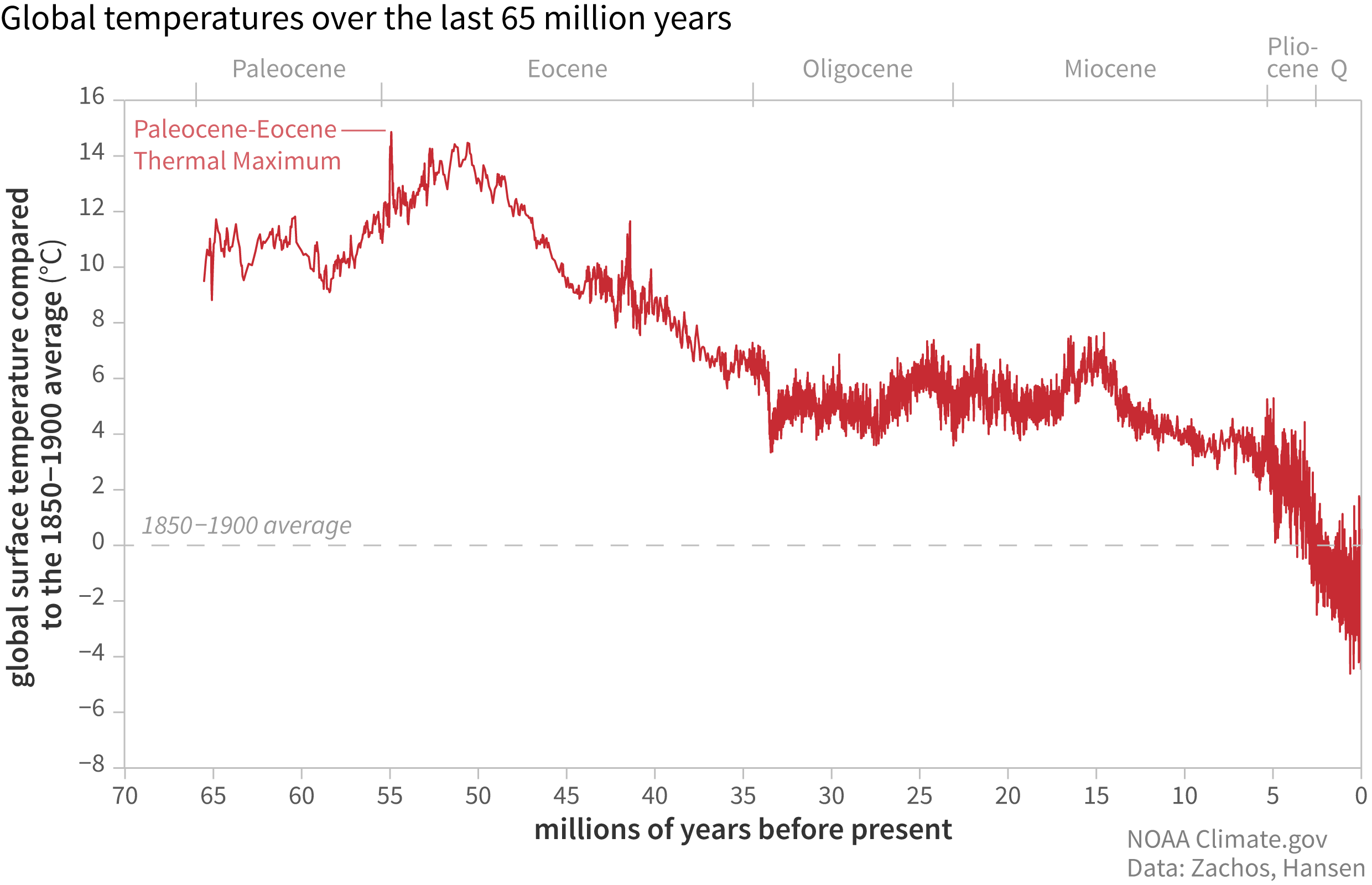
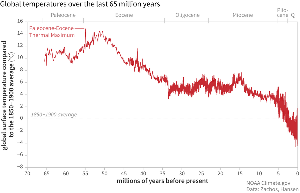
Let's go back even further Charlie! The Earth is essentially at its coolest point in the last 65 million years, but climate alarmist love to tell us the planet is “too hot” because temperatures are 1.2°C warmer than they were in 1850, the tail end of the Little Ice Age!!
-
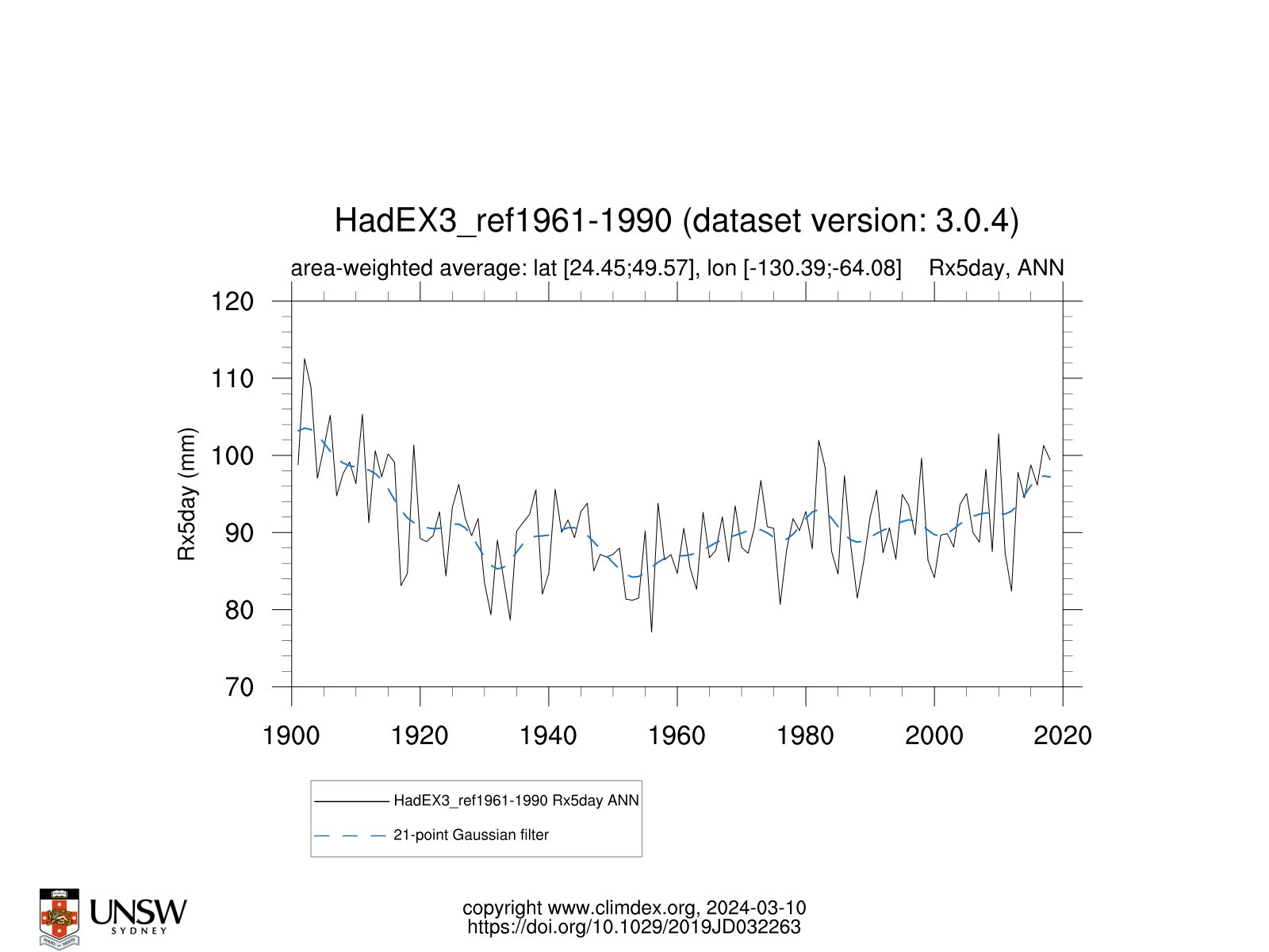
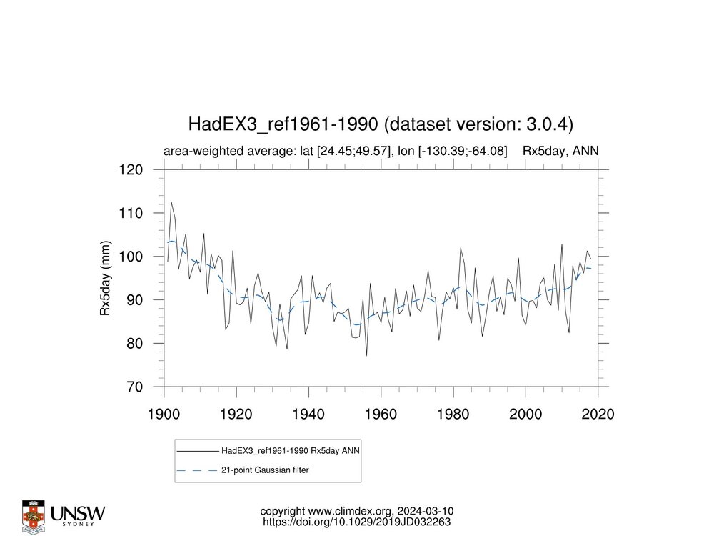
We are told by alarmists that warming of the climate is expected to increase the frequency and intensity of heavy rainfall events. One key measure of this used by climate models is the annual maximum 1 and 5-day maximum precipitation amounts (Rx1day and Rx5day, respectively). The results below indicate that while both the Rx1day and Rx5day have increased across the US since 1960....of course if we choose to go back far enough, rainfall extremes were higher than recent decades between 1901 and 1930 across both measures. Funny how weather history if we go back far enough....shows us all that is happening now has indeed occurred before. No climate emergency at all to see here!
-
hey Charlie.....there is actually weather data before 1960.....some folks don't like that data - well unless we make some chilling adjustments as it does not support the non-stop warming story. The above charts I added do not omit the older data back in our last warming cycle that you likely forgot to add...
-
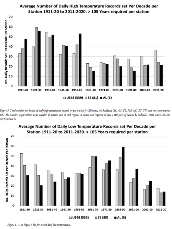
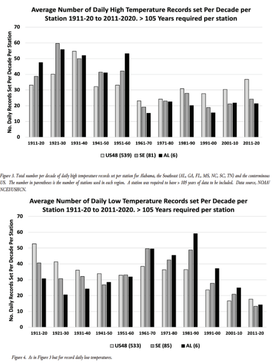
The below with a longer more appropriate time frame than Charlie showed above shows that the actual frequency of daily high temperature records in the U.S. [avg across ~540 GHCN-daily record stations] has actually decreased since 1911. The mean over the last five decades is almost 21% lower than the 1911-1960 average. Cold extremes have decreased too, and rather sharply since the 1980. Again can we say cyclical normal climate change and nothing at all to be alarmed at here??
-
Of course climate did not begin in 1979....perhaps you overlooked that one....
-
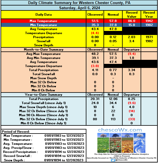
Another below normal temperature day...but at least dry across the area. Some areas by early Monday morning could see some readings near the freezing mark. A strong warming trend finally sets in on Monday with the warmest day looking like Tuesday before more showers and rain arrive on Wednesday and last through much of the rest of the work week. Chester County records for today: High temp 90 degrees Phoenixville (2010) / Low 15 Coatesville (1982) / Rain 2.03" Coatesville (1971) / Snow 4.0" Devault 4.0" (1971)

-
E PA/NJ/DE Spring 2024 OBS/Discussion
ChescoWx replied to Hurricane Agnes's topic in Philadelphia Region
Another below normal temperature day...but at least dry across the area. Some areas by early Monday morning could see some readings near the freezing mark. A strong warming trend finally sets in on Monday with the warmest day looking like Tuesday before more showers and rain arrive on Wednesday and last through much of the rest of the work week. Chester County records for today: High temp 90 degrees Phoenixville (2010) / Low 15 Coatesville (1982) / Rain 2.03" Coatesville (1971) / Snow 4.0" Devault 4.0" (1971)
-
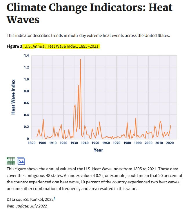
Then produce some actual real weather data like below. Funny again Charlie that all of that coast to coast heat when it really was hot back in the 1930's and 1940's needed to be adjusted in all of the post hoc after the fact data you always show. So why are we having less heat waves??
-
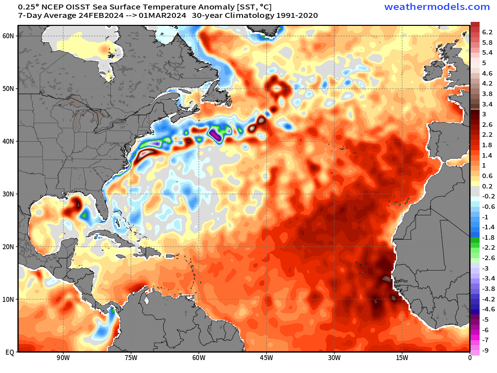
Is global cooling underway off the east coast of the US?? I guess global warming is the cause of the warming off the coast of Africa.
-
Easy answer Charlie.....there is no proof that any weather events are impacted by climate change. There are no weather events happening today that have not already occurred in the past....kind of simple!! Nothing alarming here at all!
-
Today will be our 15th below normal temperature day over the last 20 days with high temps again struggling to escape the 40's. Our below normal stretch should continue through the weekend before a nice warmup next week. Chester County Records for today: High 85.3 degrees Longwood Gardens (2010) / Low 21 degrees Coatesville (1995) / Rain 2.45" Chadds Ford (1984) / Snow 3.0" Coatesville (1898)
-
E PA/NJ/DE Spring 2024 OBS/Discussion
ChescoWx replied to Hurricane Agnes's topic in Philadelphia Region
Today will be our 15th below normal temperature day over the last 20 days with high temps again struggling to escape the 40's. Our below normal stretch should continue through the weekend before a nice warmup next week. Chester County Records for today: High 85.3 degrees Longwood Gardens (2010) / Low 21 degrees Coatesville (1995) / Rain 2.45" Chadds Ford (1984) / Snow 3.0" Coatesville (1898)
-
Thanks Tip! and of course a spectrum of alarmist forms also!! I of course do not deny nor can anyone not see that climate change is real and constant!! Your post certainly sounds a lot like a climate alarmists (CA) with a nice mix of gloom and doom with of course the absence of any actual actual unprecedented weather events.Sounds like you might even think climate change killed the aliens....of course Fermi is not a paradox at all - way way too many variables and more like mental gymnastics!
-
There are typically differences between the electronic gauges and manual. I always default to the manual gauges...
-
So how does the last several months rank among the all-time wettest out here in Chesco? For the December thru February months this season ranked as the 3rd wettest the top 5 being: 1978-79 = 21.37" / 1901-2 = 19.80" / 2023-24 = 18.83" / 1898-99 = 18.24" / 1909-10 = 18.18" For the 4 month period December thru March this season ranked 2nd with the top 5 wettest being: 1898-99 = 25.90" / 2023-24 = 24.97" / 1993-94 = 24.86" / 1901-02 = 24.80" / 1978-79 = 22.88"
-
E PA/NJ/DE Spring 2024 OBS/Discussion
ChescoWx replied to Hurricane Agnes's topic in Philadelphia Region
So how does the last several months rank among the all-time wettest out here in Chesco? For the December thru February months this season ranked as the 3rd wettest the top 5 being: 1978-79 = 21.37" / 1901-2 = 19.80" / 2023-24 = 18.83" / 1898-99 = 18.24" / 1909-10 = 18.18" For the 4 month period December thru March this season ranked 2nd with the top 5 wettest being: 1898-99 = 25.90" / 2023-24 = 24.97" / 1993-94 = 24.86" / 1901-02 = 24.80" / 1978-79 = 22.88" -
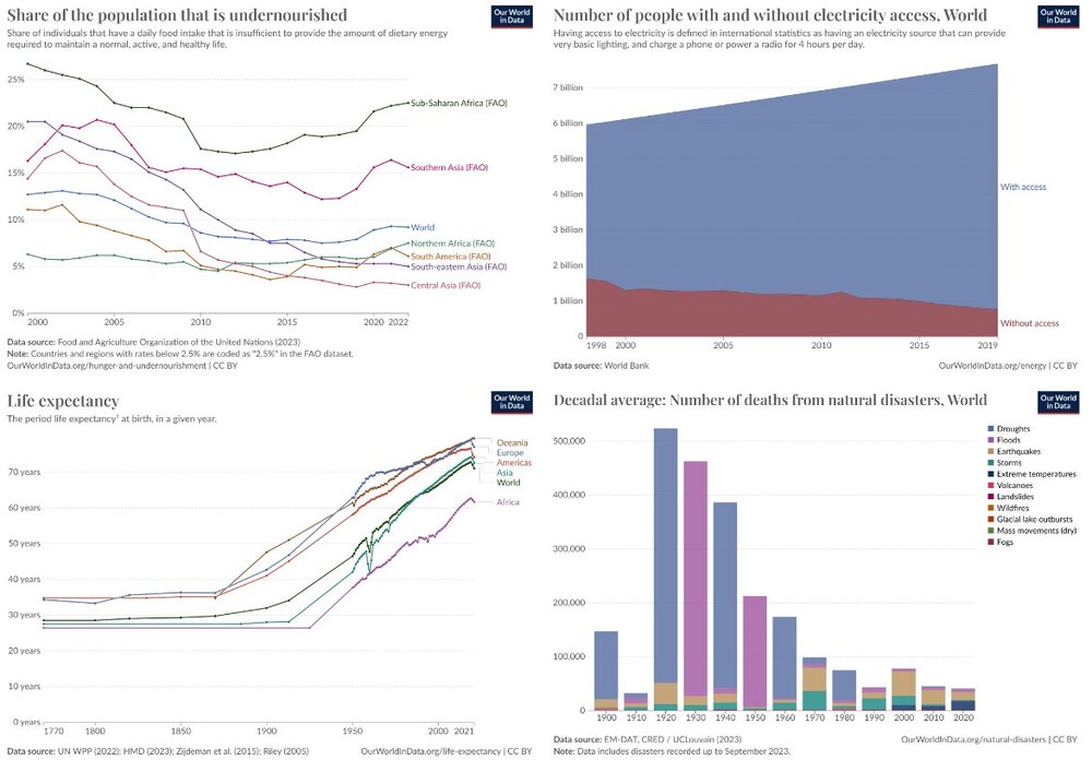
Don where is the problem again?? Life expectancy up....undernourished population down....deaths from natural disasters - down. How can all of this be happening in the world of climate alarmism? Where again is the crisis???
-
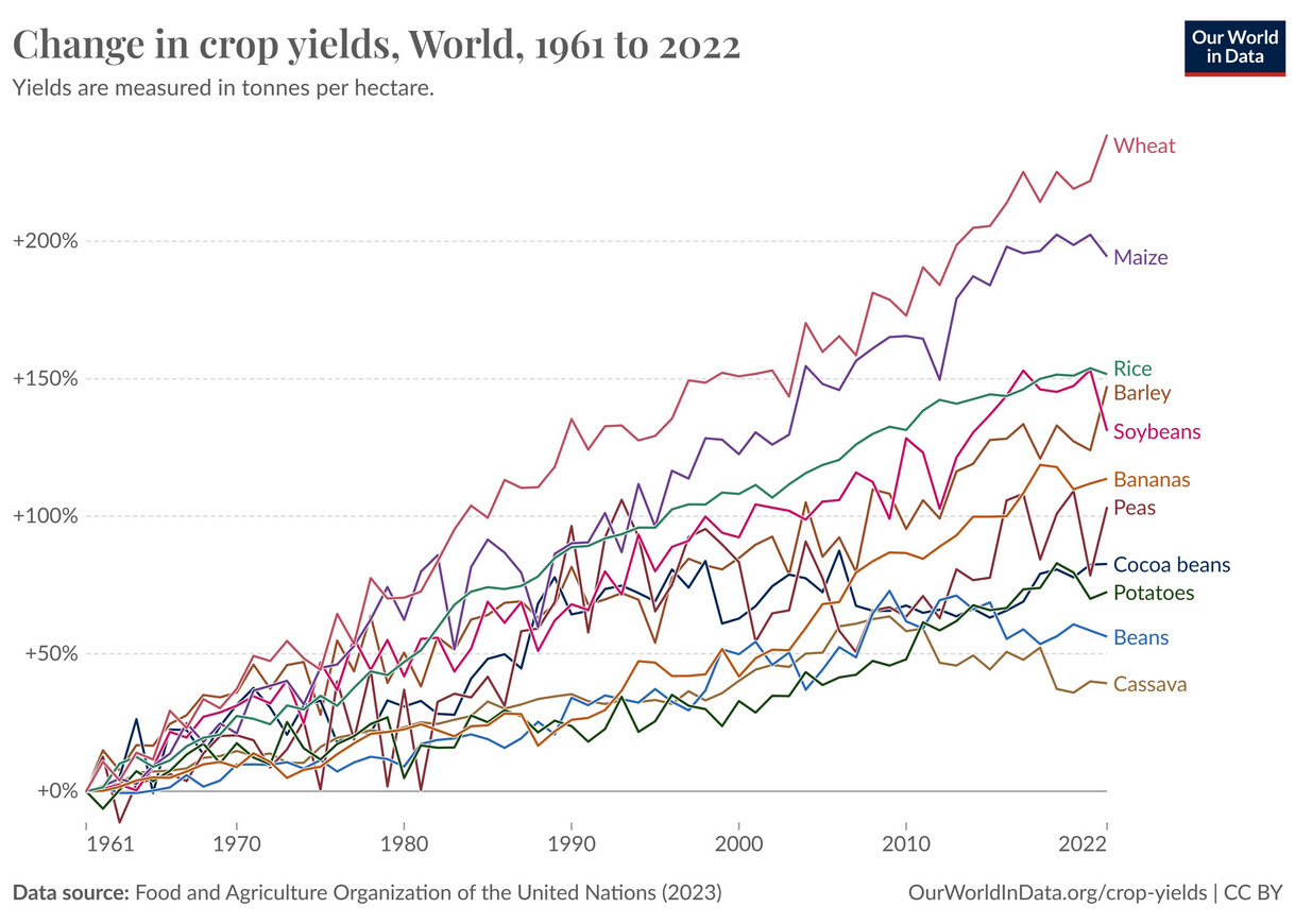
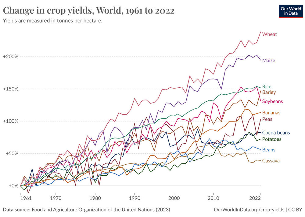
Looks like our current cyclical climate change is really hurting the world's crop production....
-
Don please provide some actual dates and events that have never happened before that are the result of climate change? Those places ravaged by fires and floods have of course been ravaged by fires and floods in the past. There is zero factual evidence....
-
Love the typical alarmist talking points - as usual Charlie shows us no facts like dates and storms that are attributable to climate change in this alarmist answer. Just the tired old bullet points that are alarmist talking points with not one shred of evidence.... you know like an actual date, storm, observation or fact. I will wait for you to list events that anyone can directly attribute to our current period of cyclical warming.