
Bluescat1
-
Posts
3,166 -
Joined
-
Last visited
Content Type
Profiles
Blogs
Forums
American Weather
Media Demo
Store
Gallery
Posts posted by Bluescat1
-
-
3 hours ago, BBasile said:
I think we have a new mini Tornado Alley. All these years in a row, now, can't be a coincidence. Not bad for April 1st.
They have been saying that the main tornado alley has shifted from texas and Oklahoma over to Missouri, Arkansas, Tennessee, mississippi and alabama. Those areas were moderate risk, now it looks like we are on the fringe of that area.
-
 2
2
-
-
30 minutes ago, Hurricane Agnes said:
And it wasn't just a full sun day but one with no clouds at all (at least where I am) all day!
Had a low of 26 this morning and made it up to 46 as a high. Air has been pretty dry to boot.
Currently clear and 43 with dp 16.
Best day so far this year.
-
1
-
 1
1
-
-
-
10 hours ago, Bluescat1 said:
30.86 at 5:45 with more to come, pollen starts to be a factor this time of year.
31.30 was the final number.
-
1
-
 1
1
-
-
1 hour ago, KamuSnow said:
I'll go with 33.12 for today.
30.86 at 5:45 with more to come, pollen starts to be a factor this time of year.
-
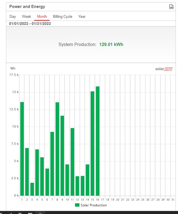
According to my solar panels April 2 was the best so far at 31.63 kwh, so far today I am at 25.04 with more sun to come.
-
1
-
-
TTN seems to be in a sweet spot. I am making pizzas on the grill for my Super Bowl party.
-
1
-
-
-
Time to start my lettuce plants inside.
-
Strange, the low has passed but my barometer keeps dropping, now 29.68?
-
Widespread panic on NY board, after 12Z runs.
-
1
-
-
6 minutes ago, JTA66 said:
fwiw…hearing the RGEM looks good.
-
2
-
-
WSW for Jersey coast.
-
Up to 35 now in TTN.
-
.A BAND OF HEAVY SNOW WILL AFFECT MERCER...SOUTHWESTERN
MIDDLESEX...MONTGOMERY...SOUTHERN BUCKS...CHESTER...NORTHERN
PHILADELPHIA AND NORTHERN DELAWARE COUNTIES...

At 540 AM EST, a band of heavy snow was located from about central
Chester County northeastward across the lower portions of Montgomery
and Bucks counties then into southern Mercer County in New Jersey.
This band is lifting northeastward.

Snowfall rates of around an inch per hour will be common within this
band. Given temperatures in the 20s and the cold ground, road
conditions are rapidly deteriorating. In addition, the visibility
will be reduced to one quarter of a mile within the heavy snow.

Be prepared for snow covered roads. Slow down and allow extra time
when traveling.

Locations impacted include...
Philadelphia, Trenton, West Chester, Bensalem, Ewing, Norristown,
Pottstown, Phoenixville, Lansdale, West Norriton, East Norriton,
Coatesville, Princeton, Westtown, Bristol, Doylestown, Downingtown,
Conshohocken, Hatboro and Ambler.

This includes the following highways...
 New Jersey Turnpike between exits 8 and 9.
-
Large flakes in TTN, 34.2, 29.96
-
I like my location near TTN.
-
1
-
-
Now casting is in order now, time to sit back and watch this develop.
-
1
-
-
These are the type of storms I like; when the first flake sticks.
-
2
-
-
I just can't stop thinking about DT's rule one on Miller B's.
-
1
-
-
Siding ripped off of house, no power.
-
The first model to have this track pinned down was the Navgem last Tuesday. It never wavered from this track.
-
When I worked for Verizon I had to go to North Jersey after Floyd. A dam burst and flooded a central office that had an open wall for construction. What a nightmare.
-
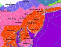
This looks like a NE NJ special, TTN just missing the pivot.


The Official Unofficial Overnight February 16/17th Snow/OBS Thread
in Philadelphia Region
Posted
Mostly a criteria difference, example Philly and Trenton, almost the same amounts.