Srain
-
Posts
7,532 -
Joined
-
Last visited
Content Type
Profiles
Blogs
Forums
American Weather
Media Demo
Store
Gallery
Everything posted by Srain
-
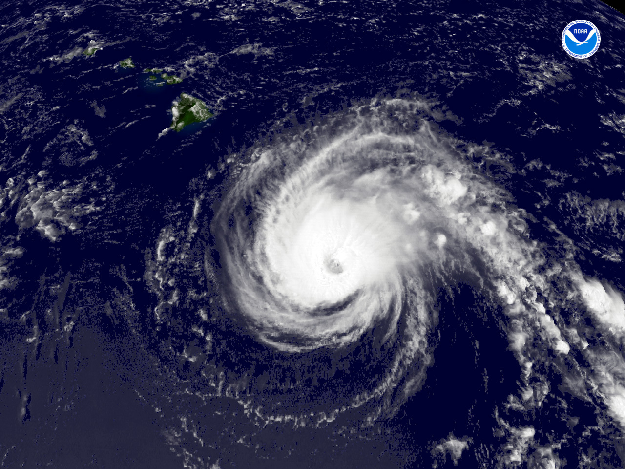 An interesting and potentially historic week ahead, tropically speaking for Hawaii. The last 12 suite of operational Global guidance suggest a rather strong TS Iselle will make its approach late Thursday into Friday from an Easterly direction. While the intensity remains very uncertain, there is warmer water E of Hawaii that may keep Iselle a bit stronger and possibly allow for a steady state as it approaches. The global guidance is suggesting Julio may fair a bit better and provide for a stronger cyclone as it approaches Hawaii on Sunday from a ESE direction, slightly S of the Iselle expected track and receive the benefit of enhanced moisture throughout the column in the wake of Iselle. The intensity guidance is split between a stronger 100 kt cyclone to a near 70 kt cyclone. The NHS is taking a reasonable conservative approach and with additional data arriving particularly from the G-IV tasked missions this week, we should see some changes in what may well be two cyclones passing very near or over the Hawaiian Islands with a matter of 3-4 days later this week into the upcoming weekend.
 -
 Major Winter Storm Febraury 8th -12th Thoughts: There continues to be a lot of uncertainty regarding the upcoming weekend and early next week as a long wave trough develops across the West. What we do know is a deep trough with a Potent Winter Storm will develop across the Great Basin and Intermountain West. In fact the HPC has so little confidence in the guidance, they have tasked a NOAA G-IV Winter RECON mission to fly the Pacific and sample the environment. Across the W, wintry conditions appear likely beginning Thursday as a potent storm system moves inland along the Pacific NW/British Columbia area and drop SSE and closes off near the California/Arizona/Mexico border with temps aloft expect to drop to the -30+ range as the cold core 500mb upper low forms. Due to lack of guidance continuity, the implications of how that storm ejects from the Great Basin is the main concern for the late weekend/early next week time frame. The HPC is mentioning this morning the similarity to a Spring like storm we tend to see in late March/early April meaning a wide spread severe weather event in the warm sector that extends from Eastern New Mexico/Texas/Oklahoma and portions of Kansas with wintry weather in the cold sector N of the Polar jet. The fly in the ointment is will there be phasing with yet another short wave riding the Polar jet across Southern Canada into the Northern Plains with the active southern jet stream storm which would tend to pull down cold air from the N and collide with warm moist Gulf air to the S. The Sub tropical jet appears to come into play as well as tropical forcing increasing across the Eastern Pacific energizing the Great Basis storm We are in a somewhat zonal split flow pattern where cold air has retreated N with an active northern stream and a secondary active southern stream where this storm system will organize later this week. All in all a very active pattern is ahead and for much of the CONUS as rain chances are returning this week to the Gulf Coastal Regions with an active southern stream and the Pacific NW as the Gulf of Alaska storm moves inland. The finer details regarding the Medium Range forecast should become bit clearer later in the week as data from WSR scheduled to begin 06/0000 regarding next weekend into early next week and the sensible weather we can expect. EXTENDED FORECAST DISCUSSION NWS HYDROMETEOROLOGICAL PREDICTION CENTER COLLEGE PARK MD 142 AM EST MON FEB 04 2013 VALID 12Z THU FEB 07 2013 - 12Z MON FEB 11 2013 DAYS 3-5... OVERNIGHT SURFACE GRAPHICS WERE ABLE TO MAINTAIN VERY GOOD CONTINUITY WITH A BLEND OF THE 3/12Z ECMWF AND ITS ENSEMBLE MEANS...ALONG WITH SOME OF THE 3/12Z UKMET. THE 4/00Z GFS GETS TO BE A FAST OUTLIER BY FRIDAY (DAY 4) WITH THE 'CLIPPER' RACING THROUGH THE OHIO VALLEY AND OFFSHORE INTO THE WESTERN ATLANTIC. THE 4/00Z UKMET-ECMWF WERE BETTER FITS TO THE MANUAL GRAPHICS AND THE PATTERN EVOLVING VS THE 4/00Z GFS-CANADIAN. WITH MUCH OF THE 4/00Z GUIDANCE IN...THERE IS PLENTY OF SUPPORT FOR COMPLEX COASTAL WAVE DEVELOPMENT AND SECONDARY INTENSIFICATION OF A SURFACE WAVE OFF THE IMMEDIATE COASTLINE (IN THE OUTER BANKS AND BLOCK ISLAND CORRIDOR) ON FRIDAY AFTERNOON/EVENING. THE MANUAL GRAPHICS CERTAINLY ARE NOT PERFECT PROGS...BUT I DID DRAW A SFC LOW TRACK (AND INTERMEDIATE POSITION)...PASSING OVER THE BENCHMARK BEFORE 9/00Z IN THE NEIGHBORHOOD OF 1004 MB AND DEEPENING TO 996MB EAST OF HALIFAX NS AROUND 9/12Z. THIS INTERMEDIATE PROG (VALID 9/00Z) IS CLOSER TO THE 4/00Z UKMET FOR DEPTH BUT HONORS THE TRACK OF THE 3/12Z ECMWF PACKAGE AND THE 4/00Z OPERATIONAL ECMWF. THE DEEPEST SFC PRESSURE AT 983 MB AS IT ENTERS THE SW GULF OF MAINE AFTER 9/00Z MIGHT BE OVERDONE...BUT THE TRENDS FROM YESTERDAY SUPPORT ONE LAST CYCLONE (CLIPPER) BEFORE THE ARCTIC AIRMASS RETREATS AWAY FROM THE EASTERN SEABOARD. DAYS 6-7... THE MEDIUM RANGE GUIDANCE HAD A GOOD HANDLE ON THE WEST COAST TROUGH AND MODERATELY-INTENSE CYCLONE EXITING THE SOUTH CENTRAL ROCKIES NEXT WEEKEND. AS ENVISIONED A COUPLE OF DAYS AGO...THE SYSTEM HAS SLOWED A TAD...BUT WILL SWEEP SOME PACIFIC ENERGY AND A WEAK SURFACE REFLECTION ACROSS THE NORTHERN ROCKIES AND THROUGH THE NORTH DAKOTA PLAINS BEFORE THIS NORTHERN END OF THE FRONT WEAKENS IN NORTHERN MINNESOTA AND WESTERN ONTARIO. THE MANUAL H5 TRACK FOR THIS SYSTEM DOWNSTREAM OF THE FRONT RANGE WAS DRAWN WITH A 'BEST FIT' LINE FROM PUEBLO CO TO MINNEAPOLIS MN GIVEN THE VARIABILITY IN TRACK AND SPEED. THE GFS IS THE MAIN REASON THERE IS 'INTRODUCED UNCERTAINTY'. I CAN NOT REALLY FOLLOW ITS RUN TO RUN ADJUSTMENTS...BUT THE H5 TRACK IS NOT FAR FROM THE TRACK ENVISIONED FOR NEXT WEEKEND. THE WESTERN GOMEX SHOULD BE WIDE OPEN AHEAD OF THIS CYCLONE. THE ONE TREND THAT WILL NEED TO BEAR WATCHING...IS...HOW THE INTENSE WEST-NORTHWESTERLY FLOW SURGING THROUGH THE 4 CORNERS AND SOUTHERN DIVIDE REGION ON SATURDAY TRANSLATES DOWNSTREAM OVER THE SOUTHERN HIGH PLAINS OF ERN NM/WRN TX LATER ON SATURDAY AFTERNOON AND EVENING. IN SOME RESPECTS...THIS PACIFIC SYSTEM LOOKS MORE LIKE A LATE MARCH/EARLY APRIL SYSTEM... WITH A WELL-DEFINED DRY SLOT AND WARM ADVECTION WORKING NNEWD ACROSS THE TX PANHANDLE AND SOUTH CENTRAL KANSAS...AND INTO THE H5 CYCLONE'S CIRCULATION. THIS MAY END UP SHIFTING THE GULF MOISTURE EAST AND SOUTH OF THE COLD FRONT INITIALLY...AND BRIEFLY LIMIT THE PHASING OF THE LOW-LEVEL MOISTURE LIFTING ATOP THE COLD SECTOR OF THIS SYSTEM INVOF 40N LATITUDE AND BETWEEN 94W-99W LONGITUDE. LIKEWISE..A DRIER EASTERLY LOW-LEVEL FLOW IS ANTICIPATED TO BE WORKING INTO THIS SYSTEM ALONG ITS NORTHERN PERIPHERY THROUGH EARLY SUNDAY. VOJTESAK View attachment: 02042013 10Z HPC Day 7 QPF p168i.gif
 -
 All eyes turn W as the upper Ridge that has brought plentiful sunshine and a January thaw to our region breaks downs down and a deep trough and potent upper air disturbances moves onshore in California and drops SSE. At the base of that Western trough, a powerful storm system develops and attempts to close off. Further N along the British Colombia/Pacific NW Coast another potent storm system moves inland setting the stage for embedded short wave activity sliding S along the W flank of the deepening trough to our W. Moisture flowing off the Gulf returns in earnest at all levels in response to the Western trough and deepening storm across Arizona/Northern Mexico as pressures fall. The Euro and its ensembles are slower and deeper with this developing storm along with the Canadian and the GEFS. The operational GFS is a bit more progressive and a tad less stormy, but there are strong indications that the Euro idea is the more likely solution and additional Winter Storm RECON is tasked for the overnight hours tonight. Beginning Monday into Tuesday, cold air building across Western Canada is pulled S into the Great Basin while warm air with increasing Gulf moisture streams N into the Southern Plains. As we saw with the Christmas Storm, such a scenario tends to suggest winter weather in the Cold sector and a severe threat in the Warm sector. The eventual track of the upper closed cold core low will be key as to where the wintry mischief falls and exactly where the greatest threat for severe weather may unfold. Another fly in the ointment is the MJO and a noisy sub tropical jet. This is a very complex and complicated weather pattern, but the trends suggest a potent Winter Storm is ahead for next week with potential wide spread societal impacts from the West Coast into the Southern Rockies/Southern Plains on N and E into the Ohio/Tennessee Valley Regions.
 -

Alaska/Western Canada obs and discussion
Srain replied to patrick7032's topic in Central/Western States
Keep us posted. I actually have family on Afognak Island just E of Kodiak... -
Alaska/Western Canada obs and discussion
Srain replied to patrick7032's topic in Central/Western States
PUBLIC INFORMATION STATEMENT NATIONAL WEATHER SERVICE FAIRBANKS AK 110 PM AKST THU NOV 17 2011 ...ANOTHER DAY OF RECORD COLD TEMPERATURES IN THE INTERIOR... THE FIRST COLD WEATHER OUTBREAK OF THE SEASON HAS SETTLED IN OVER INTERIOR ALASKA. UNUSUALLY FRIGID TEMPERATURES FOR MID-NOVEMBER HAVE BEEN OBSERVED ACROSS MUCH OF THE REGION. TEMPERATURES COLDER THAN 40 BELOW ZERO ARE BEING REPORTED IN VALLEYS IN THE CENTRAL AND NORTHEASTERN INTERIOR. INFRARED SATELLITE IMAGES ALSO INDICATE TEMPERATURES UNDER 50 BELOW ZERO IN SOME OF THE COLDEST VALLEY LOCATIONS. SEVERAL RECORD LOW TEMPERATURES WHICH WERE SET MORE THAN 40 YEARS AGO WERE BROKEN OVERNIGHT IN THE FAIRBANKS AREA. THIS INCLUDES RADIO STATION KJNP IN NORTH POLE WHICH BOTTOMED OUT AT 49 BELOW THIS MORNING...BREAKING THE PREVIOUS RECORD OF 46 BELOW SET BACK IN 1969. OTHER RECORDS FROM 1969 THAT WERE BROKEN THIS MORNING INCLUDE EIELSON AIR FORCE BASE AT 43 BELOW...THE FAIRBANKS AIRPORT WITH 41 BELOW AND THE UNIVERSITY EXPERIMENTAL STATION AT 41 BELOW WHICH BROKE RECORD SET IN 1918. OUTSIDE OF FAIRBANKS... MANLEY HOT SPRINGS REPORTED A BONE CHILLING TEMPERATURE OF 54 BELOW WHICH BROKE THE PREVIOUS LOW OF 51 BELOW SET IN 1956. RECORD OR NEAR RECORD LOW TEMPERATURES ARE POSSIBLE AGAIN FRIDAY MORNING. THE RECORD LOW FOR NOVEMBER 18TH AT THE FAIRBANKS AIRPORT IS 33 BELOW...38 BELOW AT EIELSON AIR FORCE BASE...AND 41 BELOW AT KJNP IN NORTH POLE. TEMPERATURES FROM 15 TO 35 DEGREES BELOW NORMAL WILL PERSIST OVER MUCH OF THE INTERIOR THE NEXT COUPLE OF DAYS. SOME MODERATION IS EXPECTED ON THE WEEKEND...THOUGH HIGH TEMPERATURES WILL REMAIN WELL BELOW ZERO. THE COLDER AIRMASS IS EXPECTED TO SETTLE IN OVER THE INTERIOR AGAIN EARLY NEXT WEEK. THE AVERAGE TEMPERATURE IN FAIRBANKS THIS WEEK IS AROUND 9 ABOVE WITH AN AVERAGE LOW OF 7 BELOW ZERO. BELOW IS A SUMMARY OF OFFICIAL LOW TEMPERATURES AS OF NOON THURSDAY UNLESS OTHERWISE NOTED. FAIRBANKS AREA: NORTH POLE (KJNP).......................49 BELOW (NEW RECORD) NORTH POLE WOODSMOKE SUBDIVISION........47 BELOW FORT YUKON #2...........................44 BELOW EIELSON AIR FORCE BASE..................43 BELOW (NEW RECORD) CLEAR SKY...............................42 BELOW FAIRBANKS AIRPORT.......................41 BELOW (NEW RECORD) UNIVERSITY EXPERIMENTAL STATION.........41 BELOW (NEW RECORD) UAF WEST RIDGE..........................40 BELOW (NEW RECORD) GOLDSTREAM CREEK........................40 BELOW OUTSIDE OF FAIRBANKS: MANLEY HOT SPRINGS......................54 BELOW (NEW RECORD) TELIDA RAWS.............................47 BELOW (UNOFFICIAL) CHALKYITSIK RAWS........................46 BELOW (UNOFFICIAL) FORT YUKON AIRPORT......................46 BELOW NIKOLAI.................................45 BELOW TANANA AIRPORT..........................42 BELOW NENANA AIRPORT..........................42 BELOW COLDFOOT RAWS...........................41 BELOW (UNOFFICIAL) BETTLES AIRPORT.........................40 BELOW $$ -
Welcome back Josh. May the summer bring you wound up tightly cored cyclones and many an intercept opportunity.
-
Devastating tornado strikes Joplin, Missouri
Srain replied to Hoosier's topic in Weather Forecasting and Discussion
I saw reports that he was on duty at the station, providing imformation throughout the event. -
Devastating tornado strikes Joplin, Missouri
Srain replied to Hoosier's topic in Weather Forecasting and Discussion
Good to see you back and posting like 'old times', JoMo. We wish you and yours the very best. -
Devastating tornado strikes Joplin, Missouri
Srain replied to Hoosier's topic in Weather Forecasting and Discussion
Great news! We know it's been one heck of a ride and are glad you are OK! -
Devastating tornado strikes Joplin, Missouri
Srain replied to Hoosier's topic in Weather Forecasting and Discussion
Strongly agree. -
Devastating tornado strikes Joplin, Missouri
Srain replied to Hoosier's topic in Weather Forecasting and Discussion
None at this time. -
Devastating tornado strikes Joplin, Missouri
Srain replied to Hoosier's topic in Weather Forecasting and Discussion
Bingo! We beat this same issue to death with the April events. Warnings are warnings, period! -
Devastating tornado strikes Joplin, Missouri
Srain replied to Hoosier's topic in Weather Forecasting and Discussion
The cell was warned and sirens were sounded. -
Devastating tornado strikes Joplin, Missouri
Srain replied to Hoosier's topic in Weather Forecasting and Discussion
-
Devastating tornado strikes Joplin, Missouri
Srain replied to Hoosier's topic in Weather Forecasting and Discussion
Memories of the (1953) Waco, TX tornado come to mind as well. Thoughts continue for JoMo and all those in the path. -
Devastating tornado strikes Joplin, Missouri
Srain replied to Hoosier's topic in Weather Forecasting and Discussion
CNN reports debris from St. John's Hospital in Joplin found 70 miles away... http://www.cnn.com/2011/US/05/22/severe.weather/index.html?hpt=T1&iref=BN1 -
Devastating tornado strikes Joplin, Missouri
Srain replied to Hoosier's topic in Weather Forecasting and Discussion
JoMo is one of the core members from the old Western sub forum on Eastern. Our thoughts are with those in Joplin tonight. -
Historic Tornado Outbreak April 27, 2011
Srain replied to CUmet's topic in Weather Forecasting and Discussion
-
Historic Tornado Outbreak April 27, 2011
Srain replied to CUmet's topic in Weather Forecasting and Discussion
I'm seriously laughing. Miami/Dade building codes that were put in place after Andrew certainly proved worthy for me and my old home in the Keys (adopted Miami/Dade codes in Monroe County) that was built 1999. I had $42.00 damage from Wilma while neighbors in 'older homes' lived in FEMA trailors for month afterwards. -
Historic Tornado Outbreak April 27, 2011
Srain replied to CUmet's topic in Weather Forecasting and Discussion
I will say that TWC did a great job yesterday (I had not watched their programming in my years). The Bryan Norcross/Greg Forbes team were very informative and hopefully this positive trend will continue from that organization. -
Historic Tornado Outbreak April 27, 2011
Srain replied to CUmet's topic in Weather Forecasting and Discussion
It’s not very often in the world of weather that we have a chance to witness such extreme meteorological events. It has been amazing to see the parameters and data we saw day after day come to fruition. Hopefully more lives were saved with the advanced warnings of the day. Regardless of the standing, (i.e. Super Outbreak/74) this will rank as one of the more destructive and deadly multi day events of modern US history. My thoughts are with all that have suffered from this event. -
Historic Tornado Outbreak April 27, 2011
Srain replied to CUmet's topic in Weather Forecasting and Discussion
-
Historic Tornado Outbreak April 27, 2011
Srain replied to CUmet's topic in Weather Forecasting and Discussion
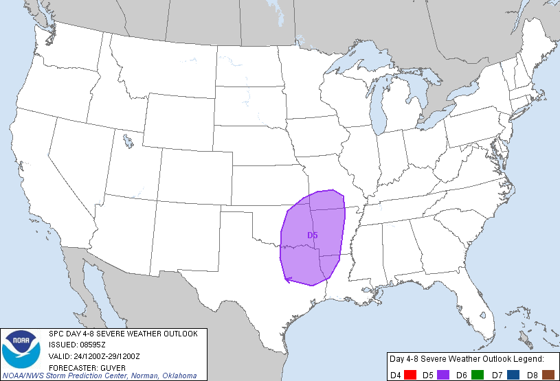
DAY 4-8 CONVECTIVE OUTLOOK NWS STORM PREDICTION CENTER NORMAN OK 0359 AM CDT THU APR 21 2011 VALID 241200Z - 291200Z ...DISCUSSION... WHILE SOME DETAILS VARY...THE 00Z ECMWF/GEFS/UKMET ARE IN AMPLE GENERAL AGREEMENT WITH THE EXPECTED AMPLIFICATION OF THE LARGE SCALE PATTERN LATE THIS WEEKEND/EARLY NEXT WEEK...HIGHLIGHTED BY A PROMINENT WESTERN/CENTRAL CONUS UPPER TROUGH. ON DAY 4/SUNDAY...THE SOUTHERN HIGH PLAINS WILL LIKELY BE A FOCUS FOR AT LEAST SOME SURFACE BASED SEVERE THREAT NEAR/EAST OF A DRYLINE ACROSS WEST TX AND PERHAPS INTO OK. OTHER ELEVATED STORMS CAPABLE OF SEVERE HAIL ARE PROBABLE SUNDAY NIGHT FROM OK INTO THE OZARKS/LOWER MO VALLEY. BUT GIVEN LINGERING UNCERTAINTY REGARDING THE EXTENT OF PRE-DARK SURFACE BASED DEEP CONVECTION...LARGELY OWING TO ANTICIPATED MODEST LARGE SCALE FORCING FOR ASCENT/ONLY WEAK HEIGHT FALLS...TOO MUCH UNCERTAINTY CURRENTLY EXISTS TO DELINEATE A 30 PERCENT EQUIVALENT SEVERE RISK AREA. FOR DAY 5/MONDAY...HAVE INTRODUCED A SEVERE RISK AREA FOR PORTIONS OF THE SOUTHERN PLAINS TO THE ARKLATEX/OZARKS. WHILE TIMING/SPATIAL DETAILS VARY TO A DEGREE...REASONABLE CONFIDENCE EXISTS THAT A SOUTHERN STREAM SHORTWAVE TROUGH WILL OVERSPREAD A MOIST AIRMASS TO THE EAST OF THE DRYLINE/COLD FRONT. AS SUCH...SEVERE STORMS SEEM LIKELY MONDAY/MONDAY NIGHT ACROSS THIS REGION. INTO DAYS 6/7 TUESDAY/WEDNESDAY...AS THE NEXT PORTION OF THE CENTRAL CONUS UPPER TROUGH PIVOTS EASTWARD...A RELATIVELY WIDESPREAD/MULTI-ROUND SEVERE THREAT IS EXPECTED FROM THE SOUTHERN PLAINS EAST-NORTHEASTWARD INTO THE MIDWEST AND LOWER/MIDDLE MS RIVER VALLEY. WHILE SEVERE STORMS SEEM LIKELY EACH OF THESE DAYS...SPECIFIC PREDICTABILITY IS STILL QUITE LIMITED IN THIS TIME FRAME. ..GUYER.. 04/21/2011