

burrel2
-
Posts
2,388 -
Joined
-
Last visited
Content Type
Profiles
Blogs
Forums
American Weather
Media Demo
Store
Gallery
Posts posted by burrel2
-
-
12 minutes ago, olafminesaw said:
I feel there's not a huge upside with this one. A bigger phase would yield a big hit for DC, but dynamics would suck down here. Of course the phase could occur sooner and to our South, but we've seen how that has been a tough ask this year. I understand the GFS is currently in a pretty good position. I just think it's a bit of a thread the needle.
I mean it has upside... look at the 00z GFS for the upside max potential... that'd be historic for some folks.
No reason to get too excited until the Euro jumps on board though. We saw this movie play out last week. (GFS showing snow and then complete cheap hooker fold). I'm a little more optimistic here though b/c the ukmet looks similar for now. And CMC has the trough axis pretty far west as well.
-
 2
2
-
-
3 minutes ago, BornAgain13 said:
Can u tell if it's a phase or not?
hard to tell much of anything on those crummy panels.
Also, no way i'm believing the qpf output on the gfs if it's right with the 500mb height map. There would be way more liquid.
-
 1
1
-
-
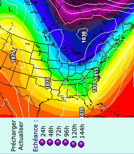
looks like a fairly potent trough on the 00z ukmet as well. Not GFS cutoff bomb material, but it's sharp.
-
Looks like a stronger/more cutoff version of the 12z ukmet really. 5h track very similar
-
mama cita!!!... check please!!!
-
1
-
 1
1
-
 1
1
-
-
I’m not going to complain bc I’ve got a decent hit from all the big ones in the that timeframe… but it’s almost always 2-3 inches of slop(except 5.5 inches with this last storm). But on the other hand 15-20 miles to my south has missed out almost entirely on all those storms.
-
Yea, especially up your way. At least your area has really cashed in on all the big ones for the last 5-6 years .
-
I think we’ve been spoiled with good December’s the last 5-6 years(not counting this year). Iirc, everyone averages more snow in March compared to December, historically.
-
5 hours ago, wncsnow said:
January is an A- here but the rest of the winter is D or F.
So December was an F. You aren’t rating February on the 7th day of the month right?
-
Where's this pattern break down again that some ppl keep calling for?

-
5
-
 5
5
-
-
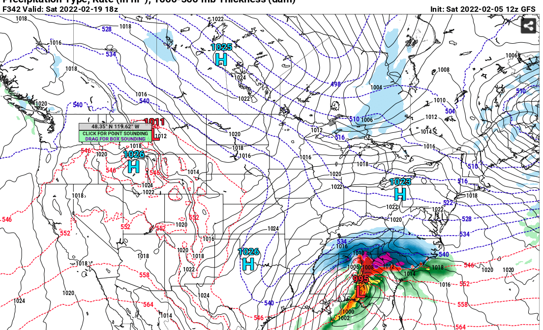
CMC also snowing over central NC at 240 hrs... the run was full of opportunities in the long range.
-
3
-
-
Not a bad look for mid-February... pattern breakdown cancel?
-
2
-
-
54 minutes ago, Taylorsweather said:
At GSP, the average high is 52 in mid January. By February 1st, it's 54. By March 1st it's 60. A six degree change over February is a strong signal that our time for snow is running out, especially during the daytime. Obviously we can all recount exceptions to this rule, but the further we go, the more perfect you need the setup to cash in. I know this is a Debbie Downer post, but given that the pattern in the East starting in mid February is not ideal, I just don't see any meaningful snows (>1"), especially in Upstate SC along I-85 where I am located. I have seen many winters and at some point the cold exhausts itself and you're left with "manufacturing" the cold to get snow. It does happen, but rarely. This post does not apply to CNC, WNC, and VA where they are closer to the cold source.
Climatology is a b!tch.
Why are you looking at average high temperatures to determine when the best chances for snow climatologically speaking? I'd think looking at historic snowfalls over the past 100 years. is more prudent. You know we have that data too, right? and Mid-Late February is "climatologically" the best time for our area to score a significant snowfall.
Does that mean we will get a snowfall this year in our climo best time??? who knows, probably not b/c it's rare in general to get a significant snowfall any time during the winter for our area. But there's no reason to call winter over at the first of February b/c "climatology".
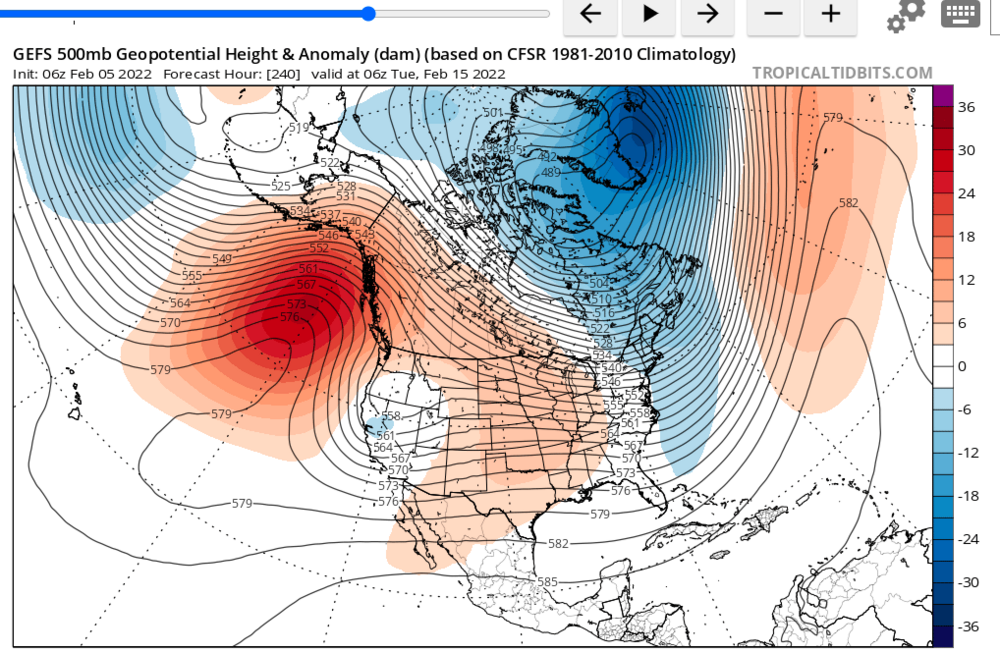
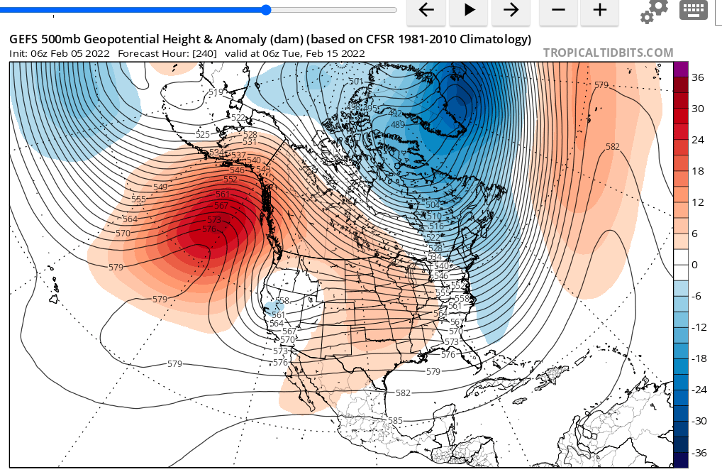
Also how are you declaring the pattern starting in mid-february will not be ideal? 1. that's 10 days away and we don't really know how it will shake out. 2. The signals are mixed right now how the pattern will look in 10 days. It certainly doesn't look like a complete torch with a west coast trough and SER... Here's the latest GEFS mean for February 15th... not horrible.
-
4
-
2
-
-
1 hour ago, wncsnow said:
You know its a bad sign for the long range when burrel has nothing to post about in here
Pattern looks ok long range to me with persistent ridging out west… the lack of threats on the models/ensembles in the long range is a little concerning though. Would like to see some storms materialize here soon in the day 8-12 timeframe before the pattern breaks.
-
you know it's a good sign for the long range when wncsnow hasn't had anything to post about in here.

-
3
-
8
-
-
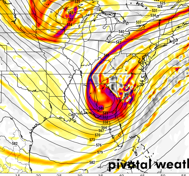
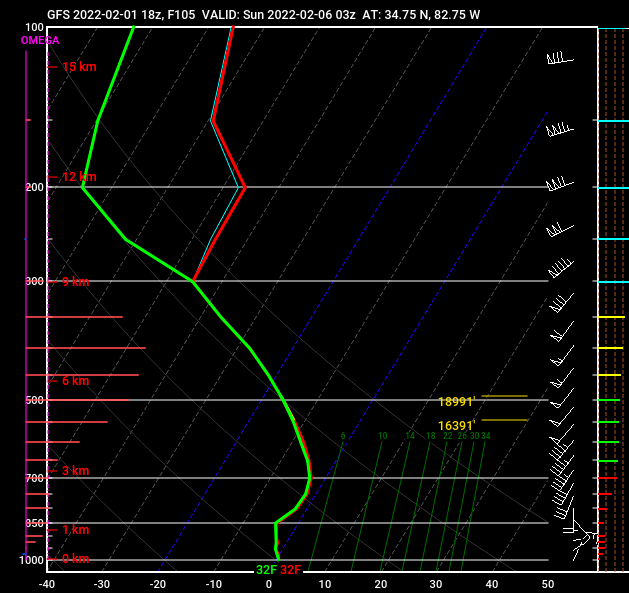
Clemson, SC sounding during the heaviest part of the storm... yes please!
-
3
-
-
More/less the models are actually in very good agreement now on most of the 5h features/timing etc... it really just comes down to really small scale interactions and orientations of the vorticity lobes within the small shortwave as it pinches off.
-
2
-
-
4 minutes ago, BornAgain13 said:
Would love for the GFS to be right but I really hate the Euro isn't on board.
Yea.. objectively I don't know what way I think this will go. It's unsettling that the Euro/CMC/ICON basically have trended worse to basically nothing today.
Ukmet still has a decent storm but both it and the gfs have trended less amped as well.
Maybe we get a windshield wipe back the other way tonight... and settle on a decent event in between. fingers crossed!
-
1
-
-
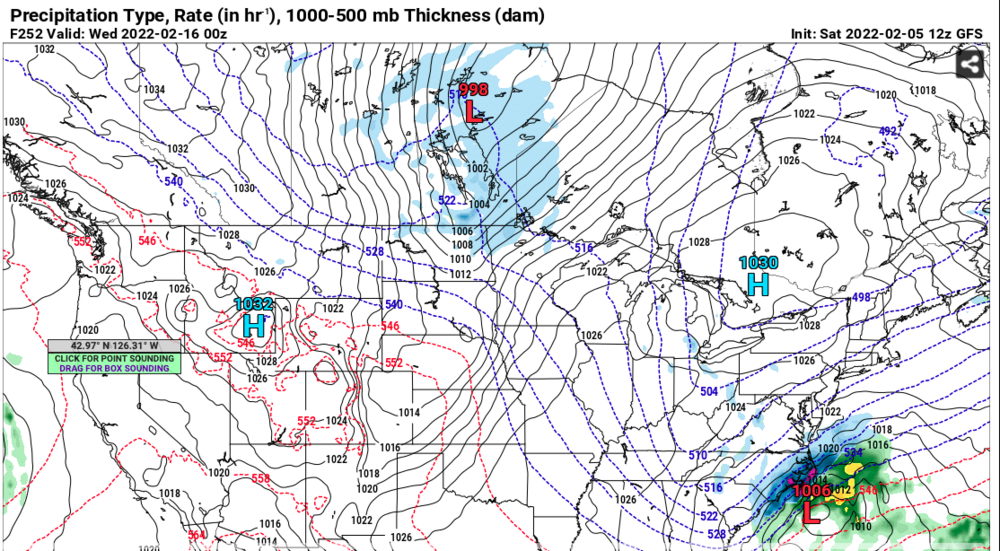
Snow starts ripping in the Upstate at 10pm Saturday night on the GFS... that's only 105hrs away. Please, please... just this once let the models converge on this solution!
-
6
-
2
-
1
-
-
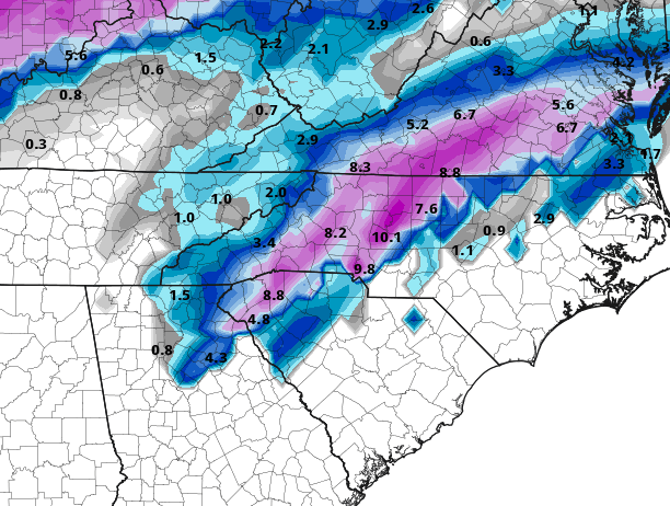
18z GFS is pure x-rated porn for the upstate, banding feature just crushes the I-85 corridor... easily all snow on the soundings with some room to spare. Here's the kuchera totals...
-
4
-
1
-
-
I hate the GFS for teasing the upstate like this. Ugh
-
1
-
2
-
-
26 minutes ago, SnowDawg said:
Changes on the ensembles looking not so good for western areas...
EPS was already pretty suppressed and dry at 00z last night and its even worse today.

And despite the super amped OP run, the GEFS is moving that direction too.

We'll see where things end up, but there's no questioning this has been the name of the game in this pattern after we scored that first storm in January.
GFS mean is a little misleading there as lots of members(including the operational) have precip falling before 1am Sunday. That's not capture in the old run b/c the storm has been sped up a good 6 hours today.
In fact, verbatim the storm is pretty much over in Western NC/SC at 1am Sunday on the operational.
-
1
-
-
Just some observations since I took notes on all the model runs for the previous two major winter storms this year.
With the big january 16th storm. the GFS was the most "wet" in my back yard for the 84-120 hour timeframe. It typically showed 1 to 1.6 inches of liquid with the event. I verified with 1.2 inches of liquid. The Ukmet was by far the worst in this timeframe as it had nothing to .05 inch totals for several runs. The Euro was also consistently too dry showing .4-.6 inch totals in this timeframe.
With the big Triangle snow storm late month... The gfs consistently showed my back yard getting 0 to .05 inches of liquid; never more than that. Meanwhile the ukmet and Euro had me getting .25 to .65 of liquid for most of their runs in this time frame. I verified with just a trace of snow; let's call it .01 of liquid.
So for both of those winter storms, the gfs was far and away the best model at predicting total liquid in my back yard in the 84-120hr timeframe...
(this is very much fwiw and probably just doesn't mean anything) lol
-
3
-
-
If they could meet in the middle that'd be great.
-
7
-

Hurricane Ian
in Tropical Headquarters
Posted
https://tidesandcurrents.noaa.gov/stationhome.html?id=8725520
6.82ft and rising.
that previous posted link of this station lags behind this one for some reason.