burrel2
-
Posts
2,388 -
Joined
-
Last visited
Content Type
Profiles
Blogs
Forums
American Weather
Media Demo
Store
Gallery
Everything posted by burrel2
-
I'll go on record saying that storm on the 12z GFS is the biggest/best fantasy storm I've ever seen modeled for South Carolina inside 200 hours. One for the fantasy record books for sure.
-
Looks like the gfs went biblical on lookouts house.
-
January 20-22 “bring the mojo” winter storm threat
burrel2 replied to lilj4425's topic in Southeastern States
I'll go ahead and cash out with the dusting the Hrrr and NAM are showing for the upstate. Can't complain if we get a nice little band to swing through and drop a coating across the upstate and NC foothills/piedmont -
12z ukmet is also robust with the precip and has Clemson, SC sounding that looks pretty interesting... it's dropping a quick 1/2 inch of liquid. Euro and CMC keep precip south of our area with the gulf low.
-
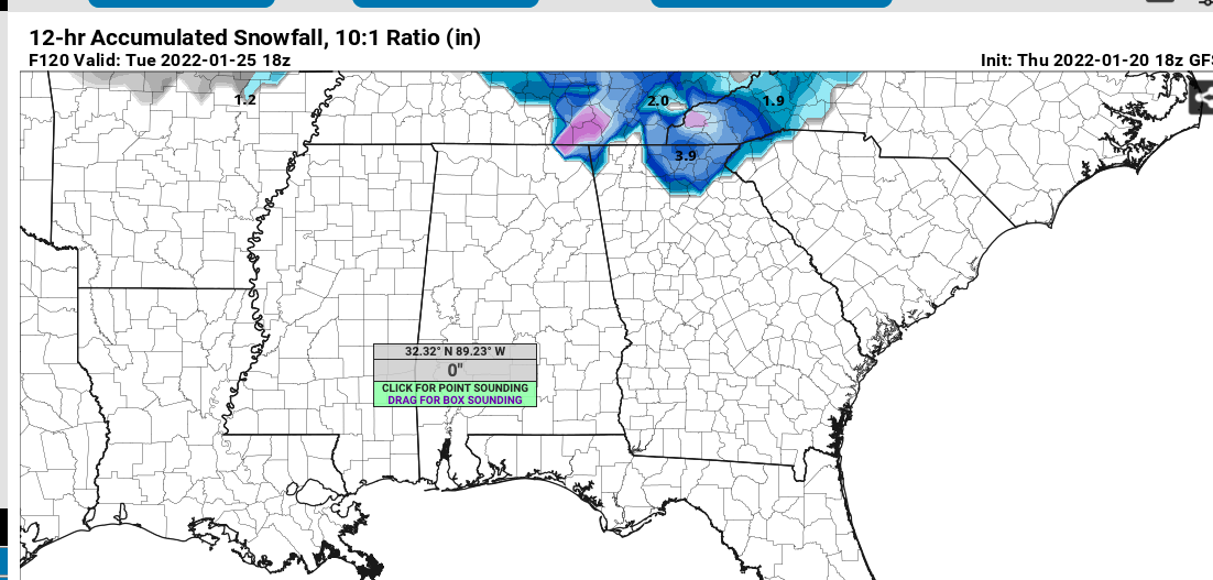
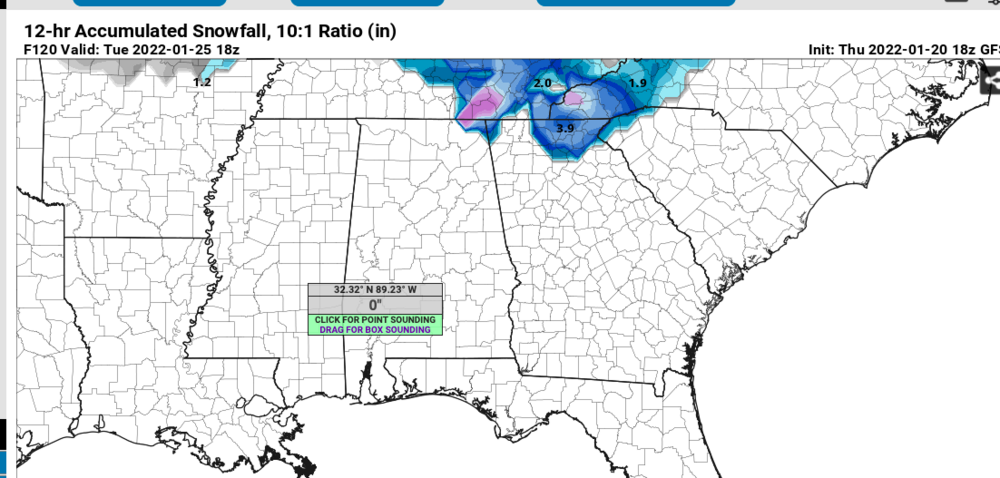
actually the 18z GFS is already showing some accumulations outside the mountains... good signs. (mountains will almost definitely do really well with this storm if there is some robust precip).
-
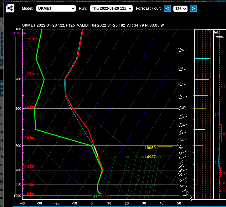
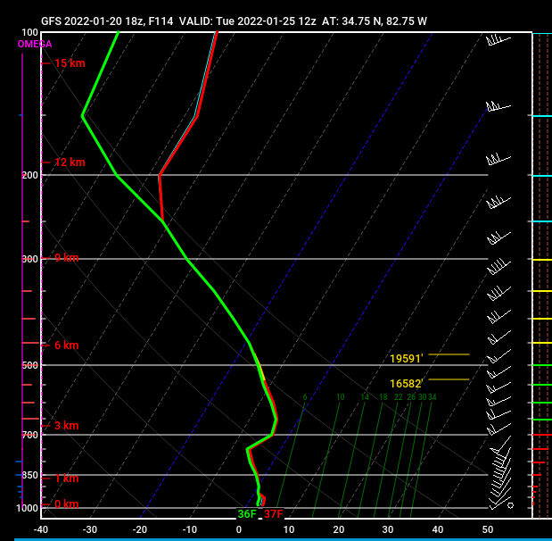
Here's the sounding off the 18z GFS for Clemson, SC at 7am Tuesday. 1/10th of liquid has already fallen and another 2/10th's fall from 7-10am and the sounding stays about the same...
-
If we wind up getting a heavy slug of moisture Tuesday morning with that gulf low... go ahead and mark me down as thinking us in NE GA and Upstate SC can possibly getting a few inches of wet snow. Globals have 850 temps wet bulbing to around -2C for that event. There are boundary layer issues and surface temps are showing 36-38 on the global models that give us precip right now. I've seen this show before though and if we do get heavy precip from that low I expect the HI-res models to come in with heavy wet snow. I went back and looked at my notes from the snow we got two years ago, which was a very similar set up. Notice in my notes that no global models ever showed snow for that storm in the medium range... i'm not saying we will get lucky again. 100 things can go wrong here... i'm just saying there is a chance with the Tuesday storm and to not write it off yet. February 8, 2020 3.25 inches all snow 31.5-32.2 all snow, started at 10:15am ended around 1:45pm hi res models showed a dusting to an inch, and warm surface temps. globals showed nothing in the medium range. verified at - 4 850's and -2 925mb. temps rose to 33.5 as it ended. beautiful tree sticking snow
-
Raleigh weenies won’t like the 15z rap. Woof
-
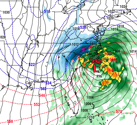
lmao, 958 mb off the delmarva coast....
-
GFS go boom. Hour 207
-
also the 00z CMC and 06z GFS both have a northern stream shortwave dropping down and sparking a coastal in the day 9 timeframe. As depicted, plenty of cold air to work with on that one, just a matte of getting it to pop in time.
-
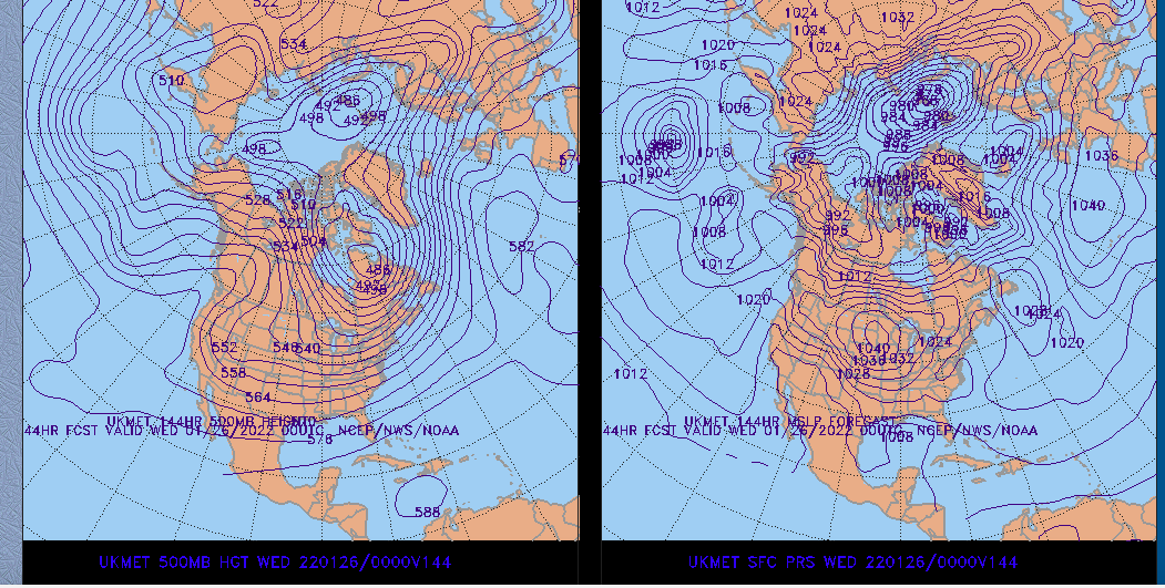
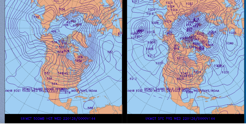
Ukmet looks like it's setting up nice at 144hrs.
-
It’s one thing for a storm to trend north or south… but this storm has been modeled to crush somebody for a week straight consistently… and 48 hours before go time, poof?
-
This really might be one for the record books. In terms of the rug getting pulled out from under everyone. Crazy
-
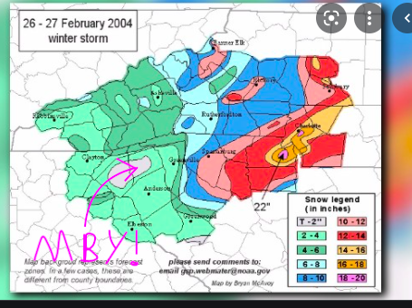
This was the all time worst though... Forecasted for 4-6 inches. Got a feather dusting. Places to my west and south got 4-6. Places to my east... well... screw those guys!
-
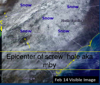
The most recent epic knife to the heart I've experienced was Feb 2014. literally everyone in a circle around me got 6-10 inches or more and somehow I managed to get 2 inches of mostly sleet that melted the next day. NWS had me getting 9-14 inches as the event was starting. Just want to add this screw hole had nothing to do with lee side warm eddies or anything like that. It was purely bad luck as the fronto band stalled just to my south for hours dumping on those people, then by the time the band shifted north the 800mb warm nose had advanced just past my house, where it stalled allowing people just to my east and north to get hammered with snow while I got sleet. Then the back side stuff minima'd me to cap off the event.
-
Actually on closer inspection they aren’t in agreement at all on the Tuesday threat, lol. Still a chance with that one though, and that’s not even the main threat to focus on… love the potential late next week… just need an evolution similar to what the gfs showed today on day 7. Ensembles have been having that similar 5h look.
-
Imo, the Tuesday morning threat could have legs for the eastern escarpment and of course the mountains. Models are actually in very good agreement on low placement and thermal profiles. We won’t have any cold air damming but it looks like the air mass in place is dry enough to drop 850s to -3c across the upstate and even colder in NC foothills when precip breaks out Tuesday morning. Combine that with Adiabatic cooling via south east flow that the global are probably under estimating and we may get a Decent 32-33 degree wet snow storm if we’re lucky. Something to watch for sure.
-
January 20-22 “bring the mojo” winter storm threat
burrel2 replied to lilj4425's topic in Southeastern States
Dang I feel bad for the triangle folk. This may not matter but I kept notes on all the model runs for last weeks storm and the NAM was too dry in my backyard in the 72-36hr time frame. The driest model by far on average and it was showing .4-.6 of liquid here a lot of runs and I wound up with 1.2. Fwiw -
12z gfs is set up for glory at day 7.
-
This thread is about to get active
-
January 20-22 “bring the mojo” winter storm threat
burrel2 replied to lilj4425's topic in Southeastern States
12z HRW FV3 is pretty much a swing and a miss for everyone.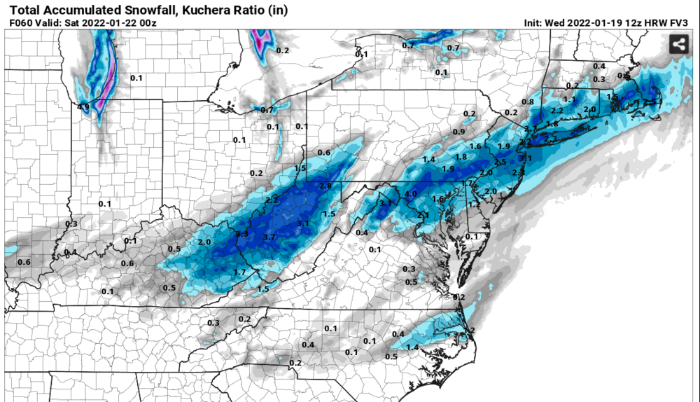
-
January 20-22 “bring the mojo” winter storm threat
burrel2 replied to lilj4425's topic in Southeastern States
northern trough weaker and more positive tilted on the NAM... gross. Another tick or two in that direction and there won't be a storm for anyone. -
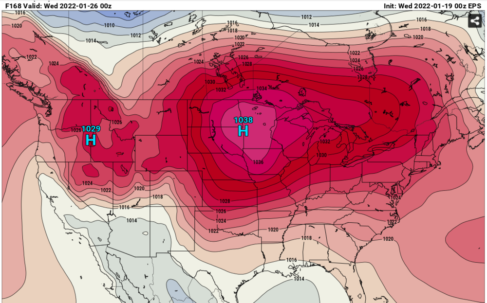
can't complain about this look on the 7 day EPS.
-
January 20-22 “bring the mojo” winter storm threat
burrel2 replied to lilj4425's topic in Southeastern States
One of the only things lending any credibility to this run!