

burrel2
-
Posts
2,388 -
Joined
-
Last visited
Content Type
Profiles
Blogs
Forums
American Weather
Media Demo
Store
Gallery
Everything posted by burrel2
-
Potential 1/28-1/30 2022 winter storm
burrel2 replied to Prismshine Productions's topic in Southeastern States
Also I see a 33 inch jackpot bullseye for NW flow mountain snow on the 3km NAM... The 6 guys who live along the TN/NC border must be excited. -
Potential 1/28-1/30 2022 winter storm
burrel2 replied to Prismshine Productions's topic in Southeastern States
So much difference with this storm between the 12km and 3km NAM for coastal area's... it's crazy. 3km NAM and Hrrr give basically nothing to D.C. and NYC. -
Potential 1/28-1/30 2022 winter storm
burrel2 replied to Prismshine Productions's topic in Southeastern States
I'd gladly trade places with you if you aren't happy with your location's chances. -
Potential 1/28-1/30 2022 winter storm
burrel2 replied to Prismshine Productions's topic in Southeastern States
Washington/NYC won't like that Hrrr run... Charlotte will though! -
Yea,I mentioned a couple days ago that it seems like the long range favors CAD/ICE and we're really seeing that on the GFS now with 3 separate CAD induced snow/ice threats in the long range. All the models have the SER flexing at least a little bit along with the great blocking and ridging out west, lends you to think we're in for some ice storms.
-
Potential 1/28-1/30 2022 winter storm
burrel2 replied to Prismshine Productions's topic in Southeastern States
Really weird how the canadian models aren't picking up on the lee-side enhancement. Every other model(hrrr,rap,3k nam, euro, gfs, ukmet) is showing it so I feel pretty safe saying the canadian's are wrong; just strange though. If I lived around Charlotte I'd be pretty giddy right now. I think they're in for a treat. -
If you just look at the major indices and 5h height anomalies across all the models for days 8-12... wowza. Does not get much better than that.
-
Not buying the cold air dump pushing that far south coast to coast... hopefully the euro moderates some on the cold air push and we can get a wave along the stalled boundary. GFS seems like a nice compromise between CMC/Euro, that's my story and i'm sticking to it until the GFS loses the mega storm anyways. lol
-
The CMC/EURO/GFS ensemble means all have a stout west coast ridge with below normal heights in the east through the extended range. It really looks like February is going to be a great month for winter storm threats.
-
Potential 1/28-1/30 2022 winter storm
burrel2 replied to Prismshine Productions's topic in Southeastern States
Congrats for the Spartanburg to Charlotte to Greensboro area. You guys are getting 2-4 inches from the meso-low. -
Potential 1/28-1/30 2022 winter storm
burrel2 replied to Prismshine Productions's topic in Southeastern States
18z Euro really jackpotting Spartanburg/cherokee/union counties in SC with the meso-enhancment. Lines up well with the winners from the 2013 event. -
Potential 1/28-1/30 2022 winter storm
burrel2 replied to Prismshine Productions's topic in Southeastern States
Yea, that wasn't a mesoscale feature though, lol. That was a mega bowling ball closed off upper level low. We won't have the upper level divergence like that one did. (We would have if the fantasy runs giving us 20-30 inches from several days ago were real) -
Potential 1/28-1/30 2022 winter storm
burrel2 replied to Prismshine Productions's topic in Southeastern States
There's going to be some epic weenie runs on the hi-res models once we get inside 48hrs I think. Both the 18z GFS(around charlotte) and 12z Ukmet(around greensboro) are showing isolated .6-1 inch liquid totals with the backside meso-low band... and those are coarse globals.... Hi-RES NAM was sexy at 60hrs too... It's got nearly 1/2 inch of liquid just north of Augusta, GA and still ripping... also another near 1/2 inch maxima east of hendersonville, NC and still ripping there too. -
Potential 1/28-1/30 2022 winter storm
burrel2 replied to Prismshine Productions's topic in Southeastern States
Dang I missed the 12z Ukmet... It shows the potential with the lee-side band. There could be some big surprises for some people in our area I think. -
Potential 1/28-1/30 2022 winter storm
burrel2 replied to Prismshine Productions's topic in Southeastern States
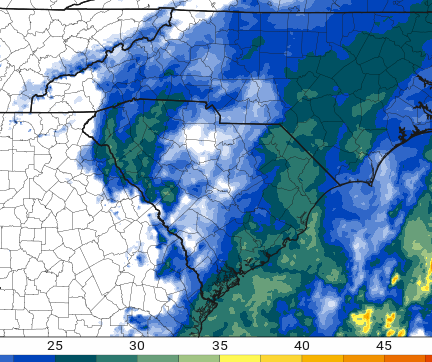
Check out the hi-res NAM... it nearly develops a closed lee-side low pressure swirl centered roughly over Columbia at the end of its run. Nice precip band swirling around it...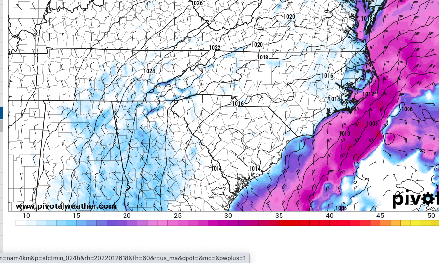
-
Potential 1/28-1/30 2022 winter storm
burrel2 replied to Prismshine Productions's topic in Southeastern States
Just another observation... it seems like the models that are really OTS and less-amped... are propagating the lee side band more in a Southeast direction... could lead to a surprise few inches in places like columbia and maybe all the way to the SC coast. The middle of the road solutions propagate it more east towards the triangle,(but fizzle it out a bit as it gets there). -
Potential 1/28-1/30 2022 winter storm
burrel2 replied to Prismshine Productions's topic in Southeastern States
Models are really honing in on that lee-side swirl hammering foothills/piedmont. IIRC, it's been a long time where we've had that feature in a snow setup... but when we did it typically over-peforms and holds together further east than models show. If I was in Central NC I would be super excited about that feature right now. And honestly it seems like you need to root for the more OTS solutions for the feature to gain steam. It makes sense I guess with the super strong N/W surface flow west of the apps... creates a nice little eddy on the lee side where things get going. The more amped/closer to the coast solution have a more northerly flow(and lower pressure field in general towards the coast), and I guess that's why they weren't as excited about this backside feature. -
2021-2022 Fall/Winter Mountains Thread
burrel2 replied to BlueRidgeFolklore's topic in Southeastern States
Just my two cents but i'll be really surprised if Asheville doesn't get at least an inch. -
Also, just in general... dang the NAM has been just awful this winter. It seems like it can't just spit out a close to reality model consensus solution... it's constantly throwing 1 percentile way off the mark solutions in both directions.
-
I'll be really surprised if the big cities miss out. This is classic mid-range NAM, imo. Rgem and Euro probably have it about right. Don't forget how ugly the NAM got for the triangle with the last storm... only to come back to the euro/rgem.
-
Potential 1/28-1/30 2022 winter storm
burrel2 replied to Prismshine Productions's topic in Southeastern States
Hopefully anybody who booked it got a refundable ticket. -
Potential 1/28-1/30 2022 winter storm
burrel2 replied to Prismshine Productions's topic in Southeastern States
This is a really odd setup where it seems like the weaker scenario's for whatever reason enhance the lee side trough. Main low is way further OTS but the lee side trough is more pronounced and as a result the hi-res models are more aggressive with that lee-side band sweeping through Upstate SC and NC piedmont. -
Potential 1/28-1/30 2022 winter storm
burrel2 replied to Prismshine Productions's topic in Southeastern States
kuchera ratio is showing 8/9 to 1 on the maps... does a surface temp at 31/32 really muck up ratio's that bad after dark? I wouldn't think so. -
Potential 1/28-1/30 2022 winter storm
burrel2 replied to Prismshine Productions's topic in Southeastern States
This has to be fairly high ratio powder, no? Not often you see a sounding that cold above the surface for the upstate. Not sure the column is saturated high enough to get really good ratio stuff though... probably will be if there's at least moderate intensity bands under the backside band... could be a beautiful inch.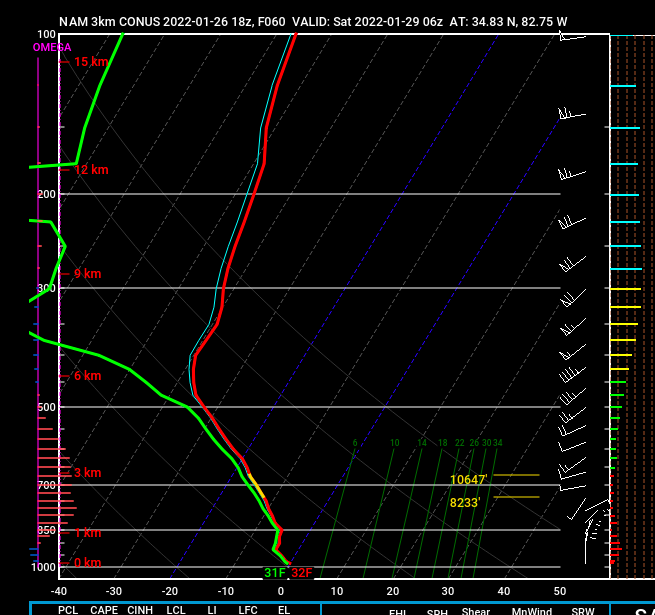
-
Potential 1/28-1/30 2022 winter storm
burrel2 replied to Prismshine Productions's topic in Southeastern States
THe 12km NAM has done this with the last 3 winter storms... A few long range runs way too amped and wet... then a few head scratching whiff runs in the 2-3 day lead time... then settles in the middle where the EURO/RGEM have been all along. Nothing to see here.


