

SACRUS
-
Posts
10,332 -
Joined
-
Last visited
Content Type
Profiles
Blogs
Forums
American Weather
Media Demo
Store
Gallery
Posts posted by SACRUS
-
-
2:PM Heat Index
ISP: 111
JFK: 111
ACY: 109
BLM: 108
EWR: 106
LGA: 104
NYC: 102-
 1
1
-
-
2PM Summer Wind
LGA: 98
EWR: 98
ACY: 97
TEB: 96
JFK: 96
IP: 96
BLM: 96
TTN: 95
New Bnswck 95
NYC: 94
PHL: 94 -
1PM HEat Index
JFK: 110
ISP: 108
EWR: 107
BLM: 106
NYC: 104
LGA: 103 -
1PM Summer Breaze
ISP: 96
LGA: 96
ACY: 96
EWR: 96
TEB: 96
JFK: 95
New Bnwck: 95
BLM: 95
NYC: 94
PHL: 93
TTN: 93 -
JFK/ISP may tie or break records the next hour
Records
7/20:
NYC: 101 (1980)
EWR: 101 (1980)
LGA: 101 (1991)
JFK: 96 (2013)
TTN: 99 (1991)
ISP: 97 (1991)
PHL: 99 (1930) -
Noon Heat Index
JFK: 109
ISP: 108
EWR: 106
LGA: 103
NYC: 100 -
Other spots for reference noon temp
BOS: 94
DOV: 94
WRI (Mcguire NJ): 94
DCA: 94
BWI: 93
MMU: 91 -
High Noon roundup:
ISP: 95
EWR: 95
LGA: 94
TEB: 94
ACY: 94
New Bnswck: 94
BLM: 93
JFK: 93
PHL: 93
TTN: 91
NYC: 91
-
TEB running high since 2016 and TTN was either recalibrated or having Central Park vegetation issues since 2015 runnning lower than what it had been previously 99-2014
-
1 hour ago, Isotherm said:
Most of those convective debris should dissipate in my opinion.
So far that's the case.

-
11AM Hot town summer in the City
ISP: 93
TEB: 93
ACY: 93
EWR: 93
BLM: 92
New Bnswck: 92
JFK: 91
LGA: 91
PHL: 91
TTN: 90
NYC: 89 -
We'll see if Judy Collins Clouds got in the way (of 100) plays later today, but certainly on our way if they dont.
IS there anyone aware if the caching of live animated loops is a site issue or user (browser issue) It seems to affect each thread where you can only post one loop then subsequent loops are the wrong times or past day.
-
10AM Roundup;
TEB: 91
EWR: 91
ACY: 91
LGA: 90
ISP:
JFK: 90
BLM: 90
New Bnswck: 90
PHL: 89TTN:87
NYC: 87 -
-
Only caveat stopping 100's are the clouds in PA from the overnight storms which are plentiful in PA and heading this way over the next 3-4 hours, we'll see how much they breakup and burn off. Otherwise off to the races.
88 here at 9:20. Matching last time went to 99.
hope these arent cached
http://mp1.met.psu.edu/~fxg1/SAT_NE/anim8vis.html
-
Midnight at the oasis
LGA: 90/74
NYC: 86/ 75
EWR: 87 / 76
PHL: 85 / 76
New Bnswck: 84/76
JFK: 82 / 79-
1
-
-
-
-
Records
7/20:
NYC: 101 (1980)
EWR: 101 (1980)
LGA: 101 (1991)
JFK: 96 (2013)
TTN: 99 (1991)
ISP: 97 (1991)
PHL: 99 (1930)
7.21:
NYC: 104 (1977)
EWR: 103 (2011)
LGA: 100 (1991)
JFK: 99 (1991)
TTN: 101 (1930)
ISP: 101 (1991)
PHL: 100 (1930) -
2 minutes ago, psv88 said:
May not bode well for hitting 100. It seems like we always fight storm debris when trying hit 100.
We'll see. ive seen this look at night and things clear up rapidly. Sunday may be the hotter day but where its sunny look for temps to exceed forecast both days, aside from the park.
-
1
-
-
Just now, 495weatherguy said:
Islip? Farmingdale?
ISP: 79/77
-
3 minutes ago, psv88 said:
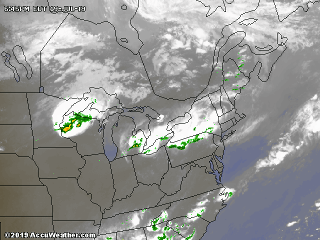
Crazy derecho in Wisconsin
Will create lots of debris clouds. Storms popping up i CPA and NY State.
-
9PM Hot summer night;
LGA: 92/73
EWR: 90/ 75
PHL: 90/75
NYC: 89/75
New Bnswck: 88/75
BLM: 86/76
JFK: 81/78 -
3 minutes ago, SnoSki14 said:
Next week will feel like fall compared to this, I think highs on Tuesday stay in the 70s.
No relief tonight though, 90/75 close to 9pm.
Urban spots may stay in the 80s tonight with a high launching pad for tomorrow.
Will need to watch how much coverage any debris clouds have and if they limit any high potential, but assuming its clear temps will blaze to highest since 2013.


July 2019 General Discussions & Observations Thread
in New York City Metro
Posted
Hard to remember and imagine in 2011 EWR (108) was 10 degrees warmer than it is now 98.