
LHSnow
-
Posts
164 -
Joined
-
Last visited
Content Type
Profiles
Blogs
Forums
American Weather
Media Demo
Store
Gallery
Posts posted by LHSnow
-
-
4.5 inches in Laurel Hollow. Lightest snow of the day now.
-
3.5 inches in Laurel Hollow. 32F.
-
2 inches and 30F at 7AM in Laurel Hollow.
-
 1
1
-
-
From Southampton
-
1
-
-
8.5 inches - NE Nassau
-
2 inches in Laurel Hollow. Intensity and wind picking up
-
All snow with a light coating in Laurel Hollow - 33F.
-
-
We have been sustained 35 to 40 mph with our highest gust of 49 mph so far. I am on the south side of Peconic Bay.
-
2
-
-
2 inches here - 15 inches on the ground
-
 1
1
-
-
Finished with 7 inches here. Have about 14 inches on the ground.
-
1
-
-
S+ 4.5 inches and 30.6F
-
About 3 inches and 30.9F. Intensity has picked up a lot in the last hour.
-
8 minutes ago, hudsonvalley21 said:
0.70 here.
.90 here on LI
-
1
-
-
Cold air returning - went from 49.8 at 11:47 to 41.2 at 11:57 - pretty good drop in 10 minutes.
-
Just now, NYCweatherNOW said:
I hear pings hope it’s stays pingy I don’t want rain
Seems to be moving quickly north. It went quickly from snow to sleet to rain on the north shore of LI.
-
Snow/sleet mix - 32.4F.
-
All snow - 32.5 - a coating
-
1
-
-
1 minute ago, psv88 said:
Yup all snow
Took photo but can’t post for some reason. Says too large
Snowing in Laurel Hollow.
-
35.6/27 - North shore Nassau.
-
1 hour ago, bluewave said:
Looks like they blended the two models for now. High end moderate and low end major are only a few inches apart. We still have another few model runs to refine the current forecast.

The higher NYHOPS is based off the NAM.
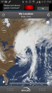
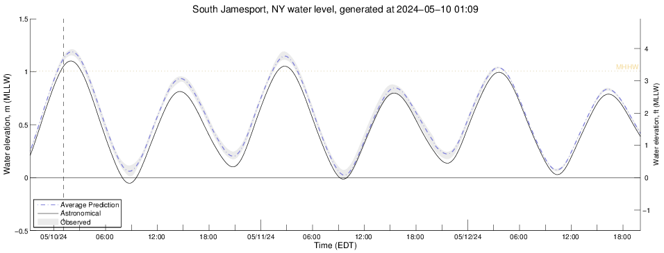
Pretty impressive surge forecasted in Peconic.
-
2 hours ago, bluewave said:
Parts of Suffolk continue the dry July pattern since 2013. This is the 6th consecutive July with below normal rainfall at Islip.
2018...2.98....-0.33 so far...normal...3.43
2017...2.11....-1.32
2016...3.22....-0.21
2015...1.74....-1.69
2014...2.96....-0.47
2013...2.34....-1.09
This is a pattern that seems to happen most summers out east where it is a lot drier than the western part of the island because they miss the thunderstorms. My house in Laurel Hollow has had 4.38 inches for the past month whereas my house in Southampton at 2.81 inches.
Two Mdt to high impact events NYC subforum; wknd Jan 6-7 Incl OBS, and mid week Jan 9-10 (incl OBS). Total water equiv by 00z/11 general 2", possibly 6" includes snow-ice mainly interior. RVR flood potential increases Jan 10 and beyond. Damaging wind.
in New York City Metro
Posted
Down to 32.9F in Laurel Hollow and moderately snowing. Roads are becoming slushy .