

djr5001
-
Posts
1,922 -
Joined
-
Last visited
Content Type
Profiles
Blogs
Forums
American Weather
Media Demo
Store
Gallery
Everything posted by djr5001
-
Since this apparently happens every year... Top 10 snowfall totals for April for Harrisburg on record: In looking at Pittsburgh's data - currently at 4.0" with 5.7" currently 10th most on record - not sure how many years are in between current 10th and 2018's 4.0" so far. Does anyone have other location's top 10s such as State College/Lancaster/etc.? edit: Here is Pittsburgh's rankings for April
-
Pittsburgh is reporting light rain/light snow and at 40F. That station over the next few hours will be a good indicator of how temperatures will be likely to respond to falling precip as this system moves east overnight. It is not so much a question of how long does it take for something to start reaching the surface but how quick do temps drop to near freezing.
-
Visibility is dropping in northern Ohio where the snow is starting - already below 2 mi with light snow being reported from Mansfield and southwest to Dayton. Down to 46F here - expecting a dip and then brief rise as clouds move in before dropping to low to mid 30s with the onset of snow. MDT reported a high of 58F today too lol.
-
Current record for MDT is the 18” event from back in the late 1800s. Hard to get much info on that event but there are historical references of a big nor’easter type storm hitting the area with DC missing out on the big totals (so 100+ years later nothing has changed lol). Ill have to look at April snow rankings but can’t imagine they are much different from the 2+” events that I had found. It’s really tough to get snow around here in April but not impossible. Crazy part about tonight is thinking it’s going to snow with how nice it is right now. Need heavy rates to get surface temps down and that is exactly what the models have had for days.
-
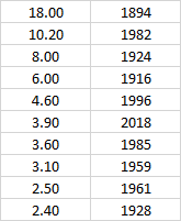
based on Harrisburg's "record" here are all days with reports of 2" or more of snowfall in April: April 7, 2003 - 2.0" April 9, 1996 - 4.0" April 9, 1985 - 2.6" April 6, 1982 - 6.3" April 9, 1982 - 3.5" April 12, 1959 - 3.1" April 27/28, 1928 - 1.5"/0.9" April 1, 1924 - 8.0" April 14/15, 1923 - 2.0"/.3" April 8, 1916 - 6.0" April 5/6, 1898 - 2.2"/.1" April 10/11, 1894 - 5.0"/13.0" So 12 2" or more events in 129 years on record (x 30 days per April) = 0.31% chance for 2" or more to accumulate in an event on any day in April in Harrisburg!
-
Some years I think we get a warm up too quickly that just scorches some of the spring vegetation. I was just looking at the February/March Harrisburg data and it is crazy to see that the current high for the month of March at MDT is 54 degrees which is 25 degrees lower than February's 79!! In fact, MDT has been below normal on average since March 5th. Average temperature so far for March is 37.1 when February was 38.7. That is quite impressive with the fact that March is the month with the greatest rise in "normal" temperature values from the start to the end that even with higher sun angle/longer days/etc. there are still ways to be colder than February.
-
I have only lost two trees and surprisingly not many branches but these last few months have had the most trees go down around me that I have seen since moving here. Had a willow tree go down the end of October and had a tree fall in January at the top of my property but that one was with winds coming straight down the ridge and my neighbor up behind me has almost all of the trees cleared for some reason on his property. It has seemed much windier than normal recently and most of these wind events have not been from severe thunderstorms but deep low pressure systems passing nearby.

