djr5001
-
Posts
1,922 -
Joined
-
Last visited
Content Type
Profiles
Blogs
Forums
American Weather
Media Demo
Store
Gallery
Everything posted by djr5001
-
Have 8” on my deck and 6” in the grass and that was measured after it had been raining for about an hour. Today turned into such a mess I think because the plows were likely waiting to start plowing/treating the roads but then schools/businesses/etc started closing and roads turned into total gridlock before plows could do anything and now it’s too late. Now that it is raining it is going to be messy for a bit and hard to clear.
-
Took me 2 hours to get home but I made it - took me over an hour to get across market street bridge
-
It was backed up into the city - I walked to my car, cleaned it off, walked back to my office
-
I'm downtown and was hoping to get to west shore via Market Street Bridge but not sure how conditions are there
-
my wife barely was able to get home - I can leave to head home but not sure I want to with the way it seems roads currently are
-
Don’t forget to report obs on mPING today! I use RadarScope app to submit any that I do.
-
I contacted them too and was told its due to it being first storm of season, healthy amount of sleet (though I don't think there is ever an amount of sleet that is healthy), and accumulations of freezing rain as to why the Warning and not Advisory edit: haha just saw that you saw my tweet to them
-
something seems strange to me with the text data - the exact same snow and ice forecast is in some of the warning areas and the advisory area Perry-Dauphin-Lebanon-Cumberland- Including the cities of Newport, Harrisburg, Hershey, Lebanon, and Carlisle 340 PM EST Wed Nov 14 2018 ...WINTER STORM WARNING IN EFFECT FROM 8 AM THURSDAY TO 8 AM EST FRIDAY... * WHAT...Heavy mixed precipitation expected. Total snow accumulations of 1 to 3 inches and ice accumulations of up to one tenth of an inch are expected. Adams-York-Lancaster- Including the cities of Gettysburg, York, and Lancaster 340 PM EST Wed Nov 14 2018 ...WINTER WEATHER ADVISORY IN EFFECT FROM 8 AM THURSDAY TO 8 AM EST FRIDAY... * WHAT...Mixed precipitation expected. Total snow accumulations of 1 to 3 inches and ice accumulations of up to one tenth of an inch are expected.
-
Hey all - just a few interesting items of note that I have for this event. First one is that I am curious to see how "modeled vs actual" obs are going to play out for the temperature profile as surface temps are going to be running about 20 degrees below normal during the day during the initial thump at the start of the event tomorrow. Models running a degree or two warmer than what actually occurs due to influence from climatology could be a difference in surface p-type for some spots (thinking snowfall total gradient sets up around Susquehanna River except for splitting York Co. with increases in totals to the west). Second is that Harrisburg has had totaled 4" or more (just picked 4" based off of higher end of some forecast totals around here) in the month of November 14 times on record (2018 makes 130th November on record) with most but not all of those 14 months have had that fall in one event. Last time Harrisburg reported 4" or more in a day was back-to-back on November 10 & 11, 1987. Fun stat about November 1987 is that it was Harrisburg's snowiest month of the season totaling 9.7" as December-January-February-March had 3.6", 9.6", 2.8", 1.0", respectively . Third and final, for now, precipitable water values are looking to be north of 1" for most of us which is crazy high for around here when at least a wintry mix is involved. With the right dynamics that is a ton of moisture for a deformation band to feed off of for some crazy rates if temps cooperate!
-
My rain gauge is sitting at 1.62” since 7am but it was coming down so hard it’s not accurate because it was over flowing
-
I have only lived here about 7 years but I’ve never seen water come down the hillside where I’m at like it is right now
-
I’m in it now and this is the heaviest I have seen from this whole event
-
I don't like that they keep lowering crest forecasts only to bump them up when new rainfall occurs later in the day. They dropped Swatara near Hershey forecast crest down to 14.6 feet yesterday afternoon and it is now sitting at 16.48 feet as of 1PM today which is now 2nd highest on record (1st is September 2011 and record only since 1975 though).
-
If any of these storms later today produce any wind it will be trouble for sure
-
Yea and that is what got us in trouble in 2011 with it being so wet for much of that year that when Lee got here things got bad quick.
-
No looks to remain active and wet for quite a while after a much needed dry day Thursday with another cold front Friday and dry for the weekend followed by another disturbance with more rain coming early next week
-
Yea I have been lucky enough to only get clipped with a few heavier cells that hit south/west/east of me yet still hit 8". I have had water come in from events in the past but somehow the area it comes in is only damp. As bad as it is getting around here we are lucky the water table underground and the river/creek levels were likely low enough at the start of the event or it would be much worse than it is already. Part of the concern too with the Susqy reaching that 21-22 feet mark is a lot of the main roads in and out of the city start to get flooded when it reaches that stage. The roads that don't flood cant handle the extra traffic. Will be interesting to see where the heavy rain sets up today and how the river level continues to rise.
-
My daily numbers since Saturday are 3.06", 1.13", 1.81", and 2.07" for a 4 day total of 8.07" and its crazy that even 8" is not close to the top reported numbers in the area.
-
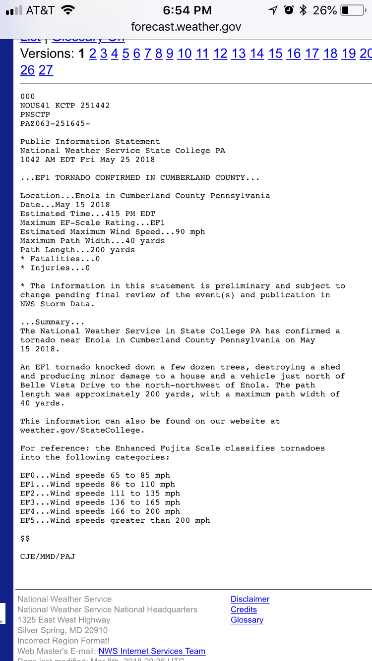
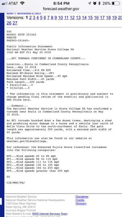
Hey did you see NWS issued a statement on Friday saying it was an EF1 just a few houses down the road from me? Crazy but I believe it based on the tree damage around here - hate I wasn’t at home when it hit to be able to describe what was happening.
-
I wasn't at home when it hit but I have sticks, branches, leaves everywhere - leaves even stuck to my siding. I had yet another tree fall (uprooted from ground being so saturated) and take out at least one other on its way down. That is now at least 4 trees I have lost since the wind storm last October. With the rain forecast the next few days if we get another round of strong winds there will be more that fall in the area. Surprisingly my power only dipped a few times, never lost it completely.
-
12z Euro continues norther trend - I can't post the maps I have but it is interesting that again the kuchera map is showing ratios greater than 10:1. York/Lancaster/Harrisburg mostly in the 7-9" range on kuchera with State College even getting some love compared to 0z. It's a big difference from 0z for DC so you can imagine how well that's going over somewhere else lol.
-
Last 8 runs of the GFS ending 18z Saturday (same as what I did with the NAM)

-
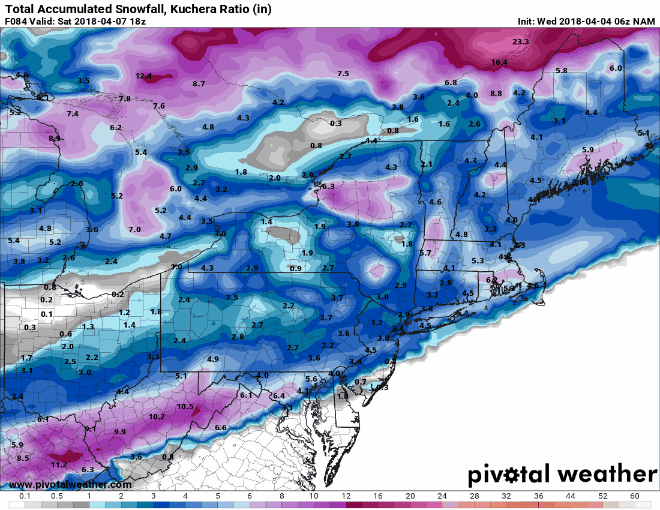
12z NAM a bit north of 6z that has snow for a bit of PA (rain to snow the more south and east you go) but event still near tail end of its range. Timing on this run is late Friday into Saturday morning for most.
-
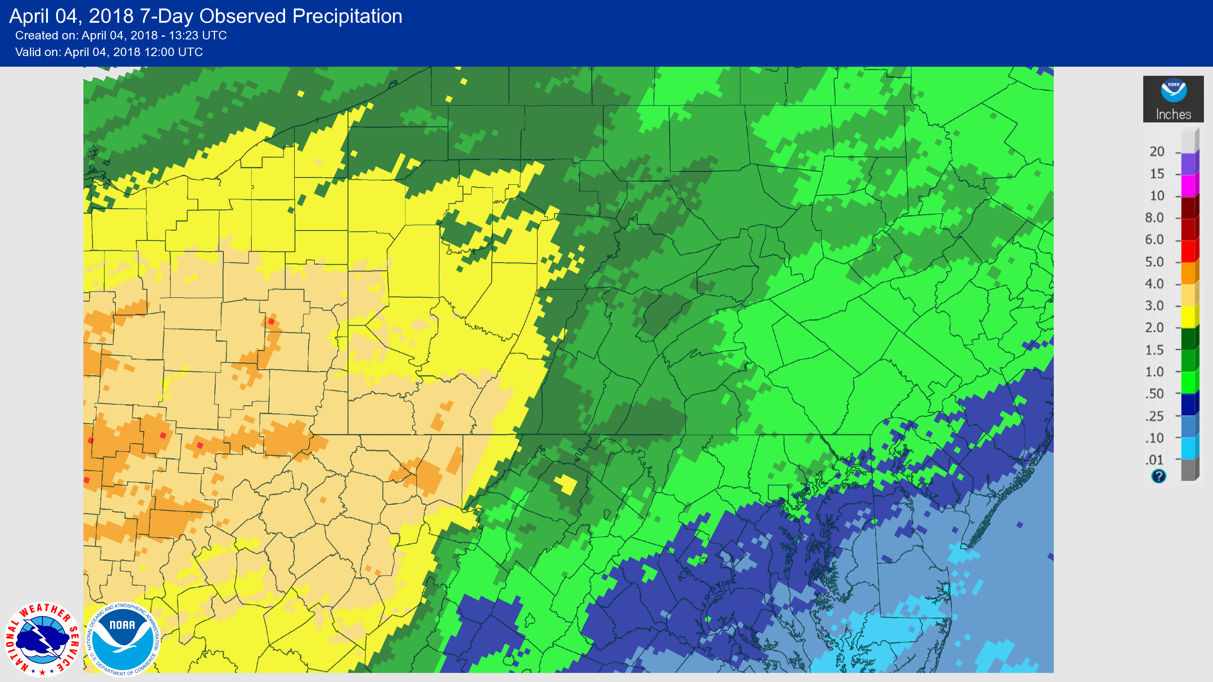
I have to imagine that this only helps to support the thought that a track a little north of what models have had is possible. That is a lot of precip through Indiana/southern Ohio that I mostly cut off for this image in just the last 7 days for late March/early April (not sure if this has all of yesterdays data yet so may edit later).

-
It should be this time of year but the 0z Euro Kuchera actually shows more for DC and west than the 10:1 map lol