
djr5001
-
Posts
1,922 -
Joined
-
Last visited
Content Type
Profiles
Blogs
Forums
American Weather
Media Demo
Store
Gallery
Posts posted by djr5001
-
-
Regarding previous difference in maps discussion - I am wondering if the weatherbell map is 28km resolution since the maps I saw posted here had “gfs 0.25” and pivotal is 13km. That would be one way to explain output map differences.
-
1 hour ago, Voyager said:
Trying to figure this out, not that it's super important, but I'm just wondering why the discrepancy...
Here is the forecast for overnight for Nesquehoning, five miles away from me, in Carbon County. They have a winter storm warning...
Tonight
Snow and sleet before 1am, then freezing rain between 1am and 2am, then rain after 2am. The rain could be heavy at times. Temperature rising to around 37 by 5am. Breezy, with an east wind 10 to 15 mph increasing to 15 to 20 mph after midnight. Winds could gust as high as 45 mph. Chance of precipitation is 100%. New ice accumulation of less than a 0.1 of an inch possible. New snow and sleet accumulation of 2 to 4 inches possible.Then here is mine, and I only have an advisory...TonightSnow, possibly mixed with freezing rain and sleet before 11pm, then snow and freezing rain between 11pm and midnight, then rain after midnight. The snow could be heavy at times. Temperature rising to around 38 by 4am. Breezy, with an east wind 10 to 15 mph increasing to 17 to 22 mph after midnight. Winds could gust as high as 30 mph. Chance of precipitation is 100%. Little or no ice accumulation expected. New snow and sleet accumulation of 3 to 7 inches possible.Yet, the criteria for a winter storm warning is the same for both counties, as evidenced by the map below.. If the criteria is the same for both counties, and we're forecasted to get more snow, then why do we have an advisory and they have a warning? To me, it doesn't make sense...
I believe I had it explained to me a few years ago that they have discretion to issue warning because of the ice when forecasted to be more than a glaze.
-
1 hour ago, sauss06 said:
we're normally almost spot on. i have 33.5. Damn front street for the win

I know I am several inches behind what others have reported in the area so this difference may be right. 4” today puts me at 20.9” for the month - I am missing some of my data so I don’t know what my season total is at the moment. I know there was at least one event (around the 10th maybe) that east shore & city had reports of an inch or two more than what I had as a heavy band just missed home to the south and east.
-
 1
1
-
-
26 minutes ago, Mount Joy Snowman said:
Yep the man knows. This is what I was getting at earlier with the near-term Meso models picking up on the sleet intrusion as we progress through the day. The resolutions of the globals always struggle with those narrow layers. Already seeing that a bit with the NAM, even more so with the 3k. Hopefully those of us north of 30 can stave it off until the heaviest rates have come through, which it seems we will.
Yep 3k NAM is showing pretty strong push of warm air around 700mb that would really knock down totals across MD/southeast PA as sleet
-
2
-
-
4 minutes ago, sauss06 said:
i'm good thanks

wouldn't that be nice
I just looked, we flipped back to all sleet.
Getting bigger flakes at home now but still a good bit of sleet mixed in - I only have 3.25” total so far
-
1
-
-
4 minutes ago, sauss06 said:
Maybe the Susquehanna river is truly the cut off lol. Its dumping here. Best snow of this event imo
@djr5001 i see you lurking. Is it dumping over home?
It at least flipped back to snow - but have been on the edge of this so far so not dumping but more moderate here
-
1
-
-
2 hours ago, canderson said:
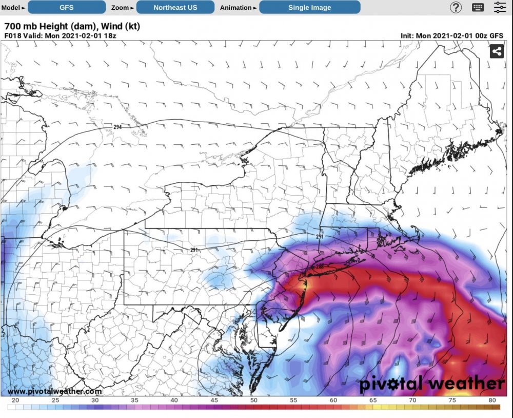
GFS is tucked with little NW precip field. Don’t get it.

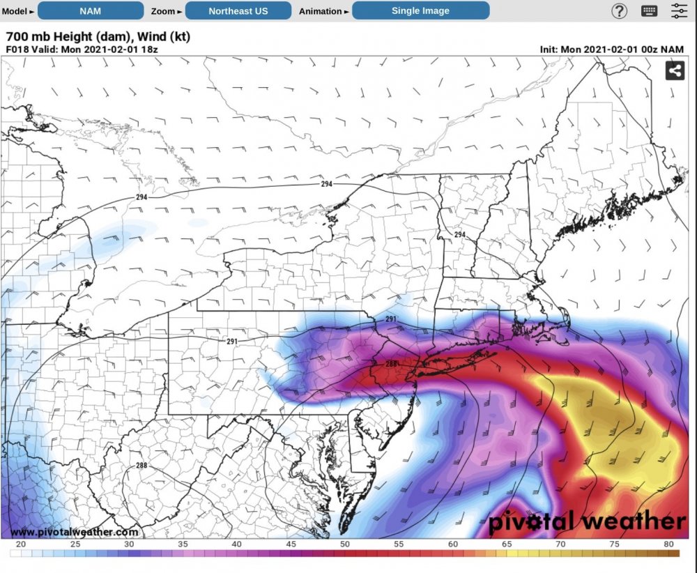
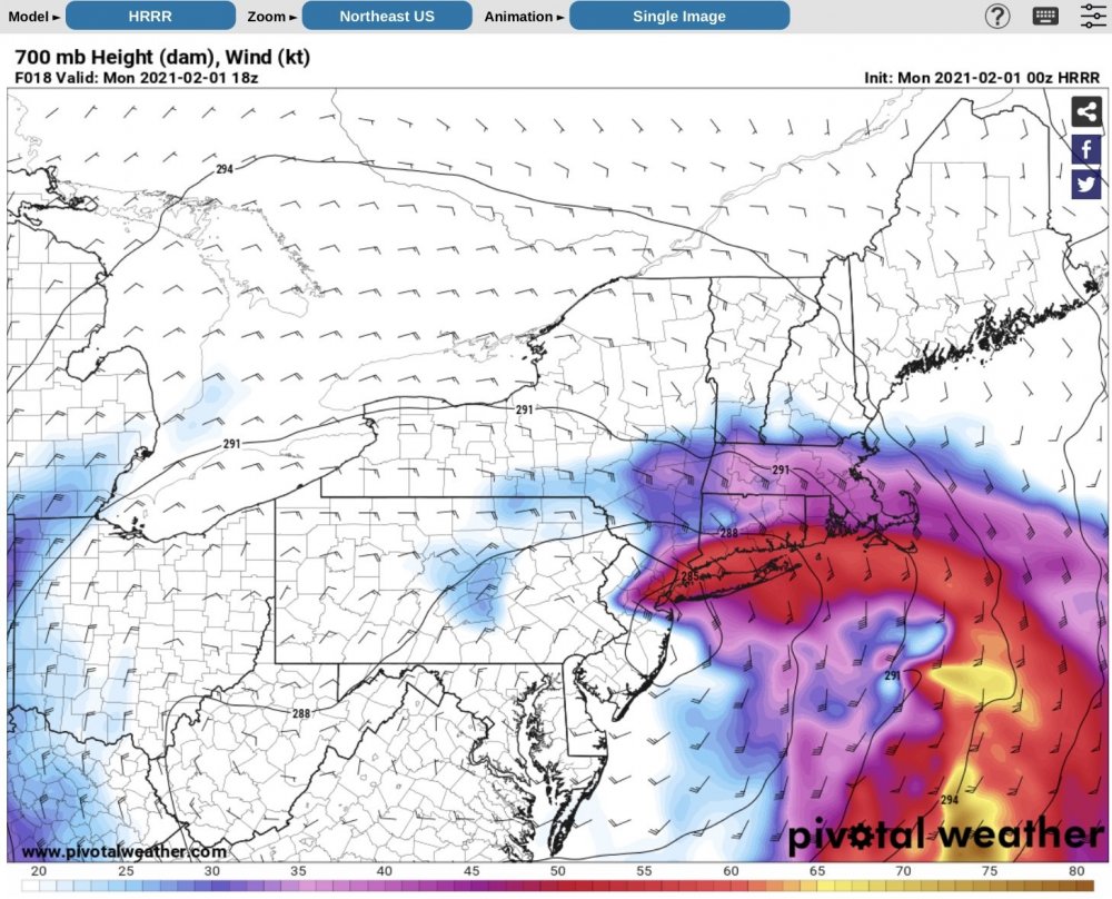
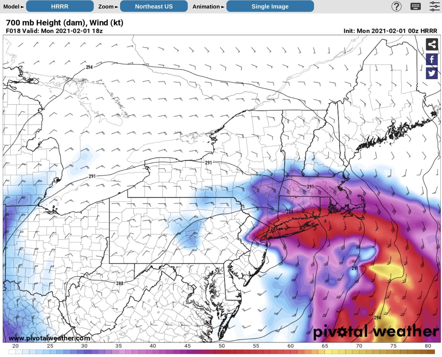
It is all about how far west the model runs are sending the upper level dynamics - the runs that are sending it west are the ones spitting out the higher numbers on the snow maps and the ones that are not look like this GFS map or the much lower HRRR solution. The upper level dry air showing up so well on current water vapor imagery already as well as the model runs worries me (as in need under banding for good snow or face dry slotting), but will have to see how things shake out tomorrow.
-
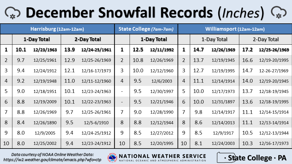
9 minutes ago, paweather said:
What is the record for the biggest snow in December those that have the record books?
-
2
-
-
-
12 minutes ago, Blizzard of 93 said:
I still am holding onto all snow for now in Marysville.
Wind picked up and it turned into a burst of best flakes of event for a few minutes but I’m back to sleet now on other side of the mountain
-
10 minutes ago, sauss06 said:
Temp back up to 24
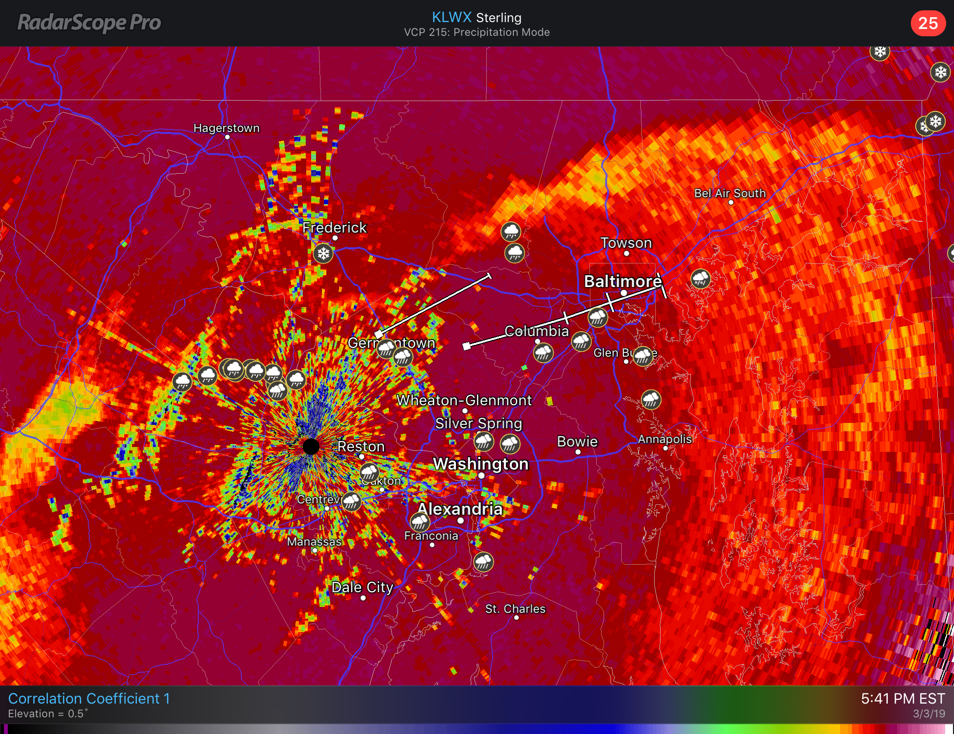
Looking at correlation coefficient imagery from the radars and mPing reports the ptype transition line is racing north and east much faster than I was expecting but with low track to our west honestly I’m not surprised... starting to wonder if more icing ends up occurring around here than was expected. Cold near surface will hold but aloft not looking likely.
-
1
-
-
6 minutes ago, sauss06 said:
It just went to like night here
Any reports of damage from around Duncannon to Halifax and just east? Radar struggles due to terrain in that area but looked like it was picking up on at least some rotation with that line that just went through.
-
KMDT only managed to fall to 16 overnight and that was briefly around 2 am when winds went almost calm for a little bit - as soon as the breeze picked back up temperatures climbed back to 20-21 degrees and stayed there the rest of the night. My snow took quite a hit yesterday from the sun and wind where I only have about an inch left in areas that the sun hits most of the day and about 4-5" depth in the some sun but more shaded areas.
-
38 minutes ago, sauss06 said:
i have 41.5"
haha that is my current running total as well - here are my records based on morning reporting times so dates may be slightly off from how others record:
11/16 - 8.0", 1/13 - 2.2", 1/18 - 1.7", 1/20 - 3.8", 1/30 - 2.4", 2/2 - 1.0", 2/11 - 1.1", 2/12 - 4.4", 2/21 - 5.0", 3/1 - 4.1", 3/2 - 3.3", 3/4 - 4.5" = 41.5"
-
1
-
 1
1
-
-
The wind has really started to pick up here in the last hour - with the drier air moving in with this wind and some march sunshine temps won't have to get above the freezing mark across the LSV the next few days to eat away at this snow unfortunately. Had a depth of 8" this morning so curious to see what that is down to later today.
-
2 hours ago, sauss06 said:
i can't even recall. I don't mind shoveling, but damn these last 3 events I've had to dig my way out of my driveway. The chit the plow truck leaves behind has been like an ice jam. I said to my wife i wondered if our township was using a different kind of rock salt or something. I have never had this issue before.
Tuesday-Thursday lows are going to be chilly
@canderson had asked about it the other day - there are a number of times that MDT reported more than a trace and even more than an inch for 3 straight days but based on time used to make those reports I am not sure that many of those are from 3 separate systems.
January 24-27 2004 and February 15-18 2003 had 4 straight days of at least 1"
As someone else pointed out last night - their totals for the last 3 days are suspicious. They are currently reporting 4.2" for the 1st with .42" liquid, 1.2" for the 2nd with .24" liquid, and 6.8" for yesterday with .69" liquid.
-
32 minutes ago, canderson said:
Also snow is done here. 5.2”. Curious what @Blizzard of 93, @sauss06 and @djr5001 report.
4.5” here - I think I just missed a good band earlier. It’s so quiet out right now all I can hear is the snow starting to fall out of some of the trees.
-
-
6 minutes ago, bubbler86 said:
I am actually not sure why they are lowering totals in N MD.
Obs down there just have not been good for them so far that it seems like they fear that area north and northeast of Frederick just isn’t going to hang on enough

-
3 minutes ago, bubbler86 said:
Euro snow map finally showed on the MA. This includes tonight so take ehhh....2-5" off this to estimate the prog's call for Sunday in the LSV. Seems like a decent 6-12". I will psot one for further up in PA if I see it.

Kuchera map has ratios slightly above 10:1 for I-81 and northwest so it adds another inch or two for much of that area around Harrisburg to an extra 3-4 inches for State College and Pittsburgh for the Sunday/Monday event.
-
Winter Weather Advisory is posted on NWS State College site for the southern counties but for some reason it doesn't look like their system pushed out the alert because it's not showing up anywhere that I usually see it...
Cambria-Blair-Huntingdon-Somerset-Bedford-Fulton-Franklin-
Including the cities of Johnstown, Altoona, Huntingdon,
Mount Union, Somerset, Bedford, McConnellsburg, and Chambersburg
1021 AM EST Thu Feb 28 2019

...WINTER WEATHER ADVISORY IN EFFECT FROM 9 PM THIS EVENING TO
8 AM EST FRIDAY...

* WHAT...Snow expected. Total snow accumulations of 2 to 4
  inches are expected.

* WHERE...Portions of central Pennsylvania.

* WHEN...From 9 PM this evening to 8 AM EST Friday.
Cumberland-Adams-York-Lancaster-
Including the cities of Carlisle, Gettysburg, York, and Lancaster
1021 AM EST Thu Feb 28 2019

...WINTER WEATHER ADVISORY IN EFFECT FROM 1 AM TO 8 AM EST
FRIDAY...

* WHAT...Snow expected. Total snow accumulations of 2 to 3 inches
  are expected.

* WHERE...Cumberland, Adams, York and Lancaster Counties.

* WHEN...From 1 AM to 8 AM EST Friday.
-
-
do we want to start a new thread now?
-
Ice definitely got close to .35-.40” range here but temp now 33 and some melting is trying to start. Clarksburg WV is currently at 58 degrees at midnight so the warm air is aloft waiting for some wind to start to mix it down to the surface.
-
1
-


Central PA - Winter 2021/2022
in Upstate New York/Pennsylvania
Posted
When visibility is low and temp is 32-34 it will show up as freezing fog i believe