

ValpoVike
-
Posts
503 -
Joined
-
Last visited
Content Type
Profiles
Blogs
Forums
American Weather
Media Demo
Store
Gallery
Posts posted by ValpoVike
-
-
2 hours ago, smokeybandit said:
XCel energy is proactively shutting off power to a lot of homes on the front range until tomorrow. Seems a bit drastic, but then again they'll get blamed for wildfires if they didn't do it.
Inconvenient yes, but not drastic If the winds increase as expected. The last time the area got hit with such winds was during the Marshall fire. Given that Xcel infrastructure was determined to be an ignition source, it is prudent.
-
I saw that too. I think it went insane for 12z but it is April.
-
12 hours ago, Chinook said:
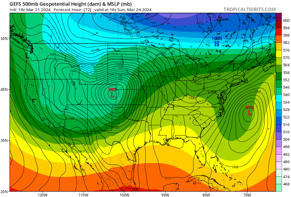
classic look for Rockies and N Plains snow and S Plains severe (see day-4 outlook on the SPC)
Taking a weekend trip to MSP. Since I will be exposed to airports on both sides, I have little faith that I will have smooth travel Sunday evening
-
Models showing another decent foothills hit for late weekend and Monday. Not nearly the QPF as last storm, but still respectable.
-
 1
1
-
-
5 minutes ago, Chinook said:
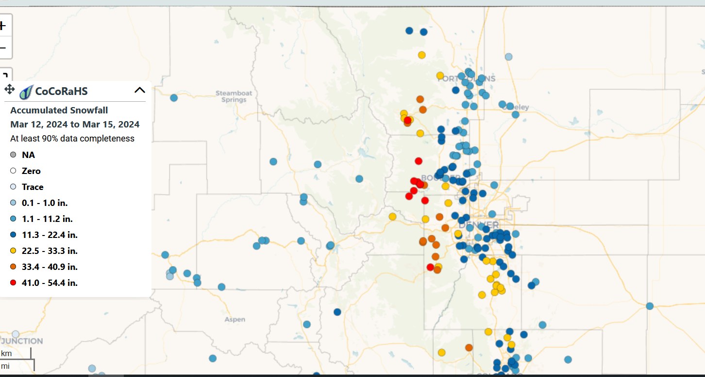
oh by the way, 41" is red
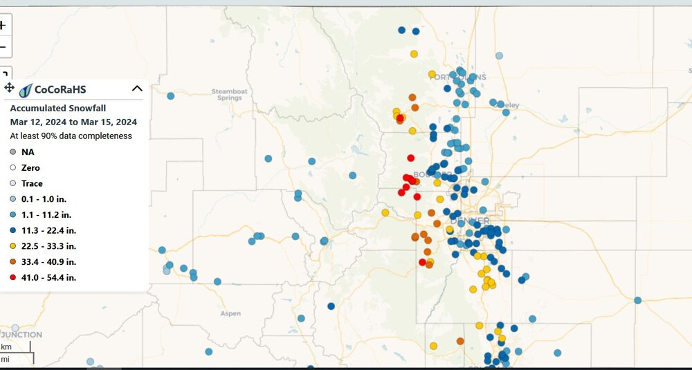
My neighbor reports to cocorahs and he measured 37” here. A great storm.
-
No worries on the backend amounts anymore. This is getting ridiculous. I have no idea how much has fallen here and I lost track many hours ago.
-
43 minutes ago, Chinook said:
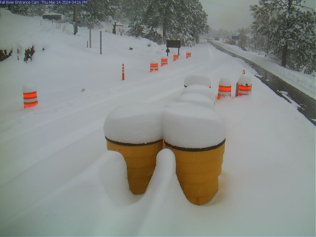
this webcam usually has no snow
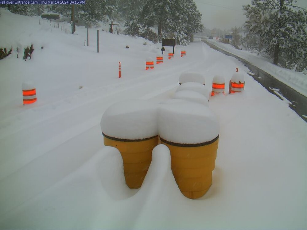
Yeah and they closed all east entrances in RMNP at 5pm on Wednesday. That is unusual.
-
Despite the slow, late start of heavier snow last night I received about 20" overnight. The Point forecast shows an additional 10-18" coming with Act Two this afternoon and evening. I share Smokey's cynical view of today's additional amounts, but we'll see. Regardless, I'm pretty happy with what I received already so it is all gravy from here on.
Looking at storm reports, I noted that Ft Collins only received about 1". That is a sharp gradient from here to there.
-
1
-
-
Still early, but nada up here so far.
-
24 minutes ago, GansettBay said:
Based on previously experience, I suspect that the changeover could happen sooner due to the strong upslope, which models often seem to struggle to account for. This could significantly increase forecasted totals on most of the models except maybe the HRRR, which shows similar QPF outputs to others, but higher snow totals. Any thoughts?
This was discussed in the noon AFD update:
In particular, there`s more aggressiveness about the late afternoon
and evening convection and resulting heavy rain/snow and cooling
temperatures. The convection allowing models typically overdo the
intensity/coverage of the higher QPF amounts and are likely doing
that this evening, but the idea of a round of vigorous showers and
a few storms along with the resulting couple degrees extra cooling
means there`s a higher threat of getting heavy snow starting a few
hours earlier this evening.
-
1
-
-
27 minutes ago, mayjawintastawm said:
The temp profiles will make this really interesting- 3 feet of concrete in the foothills??
Yeah, I am a bit concerned about that. If the QPF verifies, and it is heavy/wet, the risk to power line infrastructure and trees could be high. I am mentally prepared for an extended power outage. I will admit that I still don't trust we get these crazy QPF amounts, but the trend is strong.
-
12 minutes ago, mayjawintastawm said:
great point- Berthoud Pass was closed with actual avalanches affecting actual cars (rare!) last storm cycle, so I'd imagine CDOT will be very careful this cycle. If Berthoud's closed, only way to get to WP is I-70 through the tunnel then CO 9 up and around to US 40 East, quite a slog.
And I would think it possible that I70 get's hit with some closures as well. I think your timing will be tricky. Saturday would be way better.
-
51 minutes ago, tarheelwx said:
Thanks for the response. My only blizzard warning was the Blizzard of '93. We're supposed to ski @ Winter Park on Friday. I think we take 25 south to 70 west to 40. Think we'll be able to make it. We have an F150 4WD.
TW
Maybe the pass will be open Friday morning, but check COTRIP before heading out in the morning.
-
Warning has been issued for the front range, and it has been ramped up by another foot on high end:
WHAT...Heavy snow possible. Total snow accumulations between 18 to
  36 inches, with isolated totals up to 48 inches possible. Heaviest
  amounts expected along the eastern slopes of the Front Range,
  lesser amounts will occur west of the Continental Divide. Winds
  could gust as high as 35 mph.
-
1
-
-
Models have been consistent for a couple of days on a stripe of 24”+ across the higher foothills while the lower elevations have flip flopped somewhat. I am in the stripe, but given the track record this season I have tempered my expectations.
-
1
-
-
A watch has been hoisted for the foothills and mountains mostly east of the Divide for Wednesday a.m. thru Thursday night.
WHAT...Heavy snow possible. Total snow accumulations between 1 to
  2 feet, with isolated totals up to 3 feet possible. Winds could
  gust as high as 35 mph.
-
22 hours ago, Chinook said:
I wonder how much snow is just under the trees, just beyond the meadow.

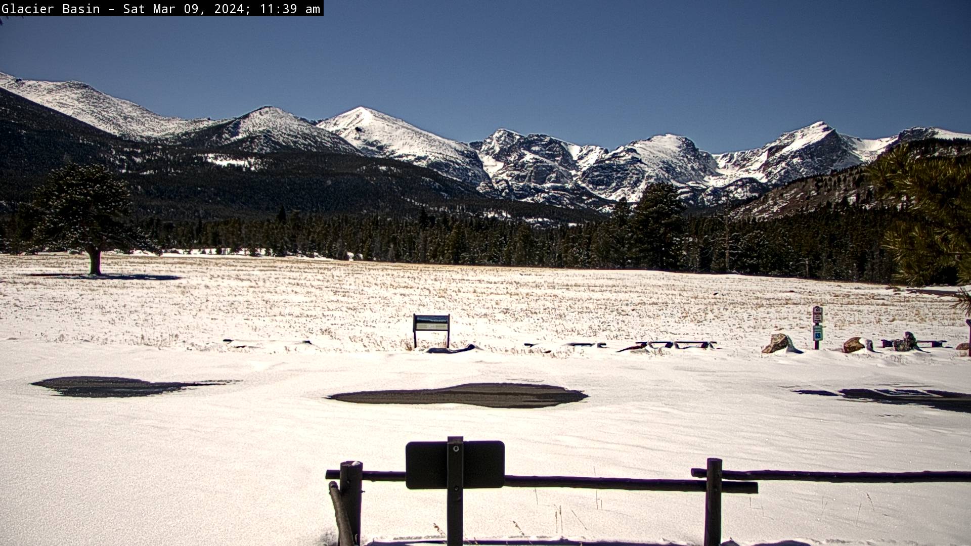
In the protected areas of rmnp at that elevation, likely between 30-36”. Around 9500’ there is a 50” snowpack. The park above 9k’ is seeing a very normal snowpack, right at 100% of seasonal average.
-
The Euro and GFS are both showing a good storm for the second half of next week for the foothills with the Euro QPF coming in at 1.5"+ and the GFS is bonkers with widespread 3"+ totals. It would be right on time for our big March events, so fingers crossed.
-
A beautiful snow up here, with large flake size. I am already at 3”. My hopes are high!
-
Spot on with the 7k’ typical cutoff. I am at 7300’ and every spring I do get some respectable dumps, but also have 1 or 2 times where my neighbors 200’ above me get all snow, while I get a mushy mostly rain mix. It is always fascinating the gradients in these spring like storms.
-
22 minutes ago, GansettBay said:
Thanks for the warm welcome! And for breaking that down for me. I moved here from RI so I'm not stranger to rain in February, but I've been waiting for the big one since I've been out here and this seemed promising early on. Overall, it seems like models generally struggle a bit more in our region and it seems to be tough to nail down a confident forecast here outside of 48 hours. I don't do any forecasting myself, but that seems to be the case for a lot of the mets I follow on Twitter and whatnot.
Patience is key. We get our big dumps in March and April. I am up near Estes and one of the biggest I have seen was in mid-May.
-
1
-
-
5 hours ago, mayjawintastawm said:
Welcome! Basically since there isn't as much measurement in the middle of the Pacific, it's harder to tell the fine details of upstream weather that feeds into the prediction models. But Chinook is a real met and could be more specific.
At least around here we don't have to worry as much about rain/snow lines with winter storms... except maybe for this one. Might be a Spring-like elevation storm. My biggest take-home message about winter storms since moving from central MA in 2010 is that QPF can magically go "poof" and vanish at the last minute. Dryness is a bigger enemy than marine warmth. Then, of course, you get things like the storm last May that dumped 6 inches of rain in 30 hours at my house.
I agree that it definitely has a March spring feel to this storm. Lot's of GOM moisture, but really sharp gradients...and heck why not, this week certainly feels like late March anyways.
-
1
-
-
7 minutes ago, smokeybandit said:
Both the Euro and GFS seeing something next weekend.
I just saw that too. The Euro in particular has some crazy accumulations.
-
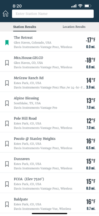
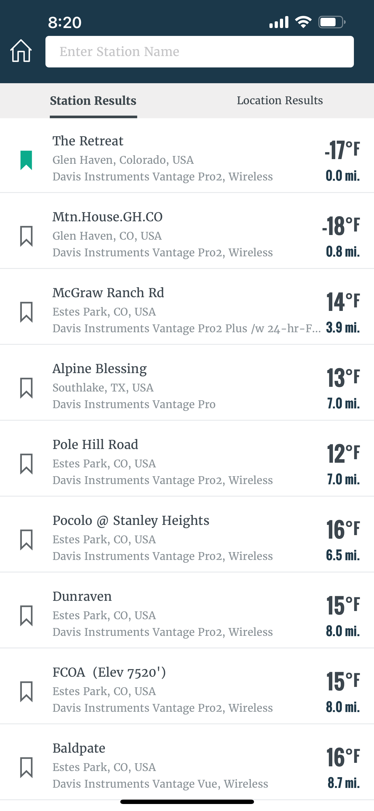
It looks like there may be a strong inversion in place or something. Looking at Davis Weathernet, my station is at -17, a nearby neighbors station is -18, but stations 5 miles away in Estes and a couple hundred feet higher are in the +teens. That’s a huge difference.

Mountain West Discussion- cool season '23-24
in Central/Western States
Posted
Winds hit 46mph a few minutes ago here and increasing. Unfortunately there is a new fire start on hwy 36 near Big Elk Meadows and Pinewood Springs, northwest of Lyons. Uggg.